Assessing the impact of explosive eruptions of Fogo volcano (São Miguel, Azores) on the tourism economy - Natural Hazards and Earth System ...
←
→
Page content transcription
If your browser does not render page correctly, please read the page content below
Nat. Hazards Earth Syst. Sci., 21, 417–437, 2021
https://doi.org/10.5194/nhess-21-417-2021
© Author(s) 2021. This work is distributed under
the Creative Commons Attribution 4.0 License.

Assessing the impact of explosive eruptions of Fogo volcano
(São Miguel, Azores) on the tourism economy
Joana Medeiros1,2 , Rita Carmo1,2 , Adriano Pimentel1,2,3 , José Cabral Vieira4 , and Gabriela Queiroz1,2
1 Centro  de Informação e Vigilância Sismovulcânica dos Açores (CIVISA),
9500-321 Ponta Delgada, Portugal
2 Instituto de Investigação em Vulcanologia e Avaliação de Riscos (IVAR), Universidade dos Açores, 9500-321 Ponta

Delgada, Portugal
3 Centro de Investigação em Biodiversidade e Recursos Genéticos (CIBIO), InBIO Laboratório Associado,

Pólo dos Açores, 9500-321 Ponta Delgada, Portugal
4 Faculdade de Economia e Gestão da Universidade dos Açores, Universidade dos Açores, 9500-321 Ponta Delgada, Portugal

Correspondence: Joana Medeiros (joana.fc.medeiros@azores.gov.pt)

Received: 23 July 2020 – Discussion started: 4 August 2020
Revised: 11 December 2020 – Accepted: 11 December 2020 – Published: 29 January 2021

Abstract. The Azores are an active volcanic region that of-        1   Introduction
fers exceptional conditions for nature-based tourism, one of
the main axes of economic growth in the archipelago. A fu-
ture volcanic eruption may have long-term consequences to          Among all natural phenomena on Earth, explosive volcanic
this economic sector. Therefore, it is fundamental to assess       eruptions are one of the most destructive and can cause ma-
its vulnerability to volcanic hazards in order to try to miti-     jor socio-economic impacts. Explosive eruptions can affect
gate the associated risk. This study proposes a new approach       large areas of land, ocean and airspace, threatening people,
to assessing the economic impact of explosive eruptions on         animals, buildings, infrastructure, transportation, communi-
the tourism sector. We considered two eruptive scenarios for       cations, agriculture land and water resources (e.g. Guffanti et
Fogo volcano (São Miguel Island), the most probable (Vol-          al., 2005; Spence et al., 2005; Wilson et al., 2012; Scaini et
canic Explosivity Index, VEI, 4 sub-Plinian eruption) and the      al., 2014; Wilson et al., 2014; Craig et al., 2016; Brown et al.,
worst-case (VEI 5 Plinian eruption), both producing tephra         2017; Kueppers et al., 2019). In more extreme cases, explo-
fallout and pyroclastic density currents. The results of numer-    sive eruptions may also affect global climate (e.g. Rampino
ical simulations were overlaid with tourism-related buildings      and Self, 1982; Hansen et al., 1992).
and infrastructure of Vila Franca do Campo municipality to            Despite the numerous hazards related to explosive volcan-
identify the elements at risk. The loss present value method       ism, in several places volcanoes are regarded as attractions
was used to estimate the benefits generated by the accommo-        and not as a potential sources of problems. For some com-
dation units over 30 years for different economic scenarios.       munities, nature-based tourism plays a significant role in the
The assessment of the economic impact using 2018 indica-           development of the local economy. However, the potential of
tors reveals that in a near-total-destruction scenario, the eco-   some volcanoes to produce hazardous explosive eruptions is
nomic loss is approximately EUR 145 million (considering a         often overlooked or underestimated.
2 % discount rate). This approach can also be applied to other        The 1995 eruption of Soufrière Hills volcano, on Montser-
volcanic regions, geologic hazards and economic sectors.           rat island (Lesser Antilles), is a dramatic example of the ma-
                                                                   jor impact that a volcanic eruption can have on a local com-
                                                                   munity. This long-lasting eruption led to the island’s largest
                                                                   migratory outbreak, with approximately 70 % of the popula-
                                                                   tion leaving Montserrat (Kokelaar, 2002; Annen and Wagner,
                                                                   2003; Hicks and Few, 2015). Before 1995, Montserrat had

Published by Copernicus Publications on behalf of the European Geosciences Union.
418                                           J. Medeiros et al.: Assessing the impact of explosive eruptions of Fogo volcano

a prosperous tourism industry, with revenues accounting for         Azorean tourism underwent a significant boost since 2015
approximately 25 % of the island’s gross domestic product           with the alteration of the accessibility and mobility model,
(GDP) (Caribbean Community Secretariat, 2009, in Pacheco            the importance of this sector in the regional economy has
and Lewis-Cameron, 2010). The eruption had a significant            grown over the years. Therefore, it is fundamental to assess
impact in this sector, with a decrease of roughly 50 % in ar-       its vulnerability to volcanic hazards in order to implement
rivals between 1995 and 1996, reaching an all-time low in the       appropriate mitigation strategies.
following year, with a decrease of 44 % relative to 1996. The          São Miguel Island is the largest (744 km2 ) and most pop-
stabilisation of the volcanic activity in 1998 led to a 50 %        ulated (> 137 000 inhabitants) of the Azores archipelago,
increase in arrivals compared to 1997. Although the erup-           where most of the tourism industry is concentrated. The vol-
tion caused the destruction of critical infrastructure, includ-     canic history of São Miguel shows that it is the most ac-
ing the airport and harbour, and the capacity to accommo-           tive island in the Azores, with the highest eruptive frequency
date tourists, this sector has recovered steadily, as shown by      of explosive events. At least 34 explosive eruptions (sub-
the increase in tourist arrivals in 1997 and 1999, from 5000        Plinian and Plinian) are known to have occurred in the last
visitors to approximately 10 000, respectively (Pacheco and         5000 years. Fogo volcano, located in the central part of São
Lewis-Cameron, 2010). Even though the last significant ac-          Miguel, was the only volcano that produced a Plinian erup-
tivity occurred in 2010, officially it is still considered an on-   tion in this time frame, although it has the lowest eruptive
going eruption (Wadge et al., 2014; Hicks and Few, 2015);           frequency of the three active central volcanoes of the island
yet tourism continues to grow, with Soufrière Hills volcano         (Gaspar et al., 2015a). Nonetheless, its potential to produce
representing the island’s most important geological monu-           hazardous explosive eruptions must not be underestimated,
ment (Pacheco and Lewis-Cameron, 2010).                             and the economic impact of future eruptions should be prop-
   Taking another perspective, the 2010 eruption of Eyjafjal-       erly assessed.
lajökull volcano (Iceland) drew attention to the vulnerability         In this framework, we aim to evaluate the impact of fu-
of modern society to the atmospheric dispersal of ash plumes.       ture explosive eruptions of Fogo volcano on the tourism of
The peculiar characteristics of this eruption combined with         São Miguel, taking Vila Franca do Campo municipality as
specific meteorological conditions resulted in the dispersal        a study area. To assess which areas and exposed elements
of volcanic ash over large areas of the North Atlantic Ocean        are susceptible to being affected by tephra fallout and pyro-
and Europe (e.g. Gasteiger et al., 2011; Gudmundsson et             clastic density currents (PDCs), two eruptive scenarios were
al., 2012). Despite the moderate size and duration of the           considered: the most probable scenario, corresponding to a
eruption, it caused unprecedented disruption to civil aviation      sub-Plinian eruption with a Volcanic Explosivity Index (VEI;
over European airspace, with more than 8.5 million passen-          Newhall and Self, 1982) of 4, and the worst-case scenario,
gers stranded (Alexander, 2013). The aviation sector is ex-         corresponding to a Plinian eruption with VEI 5. The assess-
tremely important to the global economy since it represents         ment was carried out on buildings related to tourism and al-
0.7 % of the world’s GDP and 35 % of world trade (Páls-             lowed the estimation of which exposed elements could be
son, 2010). The overall GDP loss resulting from the long-           affected, with physical damage and loss of functionality. The
term incapacity to move people and assets was estimated             methodology proposed consists of evaluating the benefits
at approximately USD 4.7 billion, including airline industry        generated by the tourism industry, restricted to the quantifi-
losses and economic losses at touristic destinations as well as     cation of revenues generated by accommodation units, to de-
general productivity losses (Oxford Economics, 2010; Pallis-        termine the current loss of that revenue over 30 years. Such
ter and McNutt, 2015). Although locally this eruption had a         analysis is especially important as tourism is a growing and
reduced impact, statistical data estimate that between April        promising activity in the Azores in general (Vieira et al.,
and May 2010 the number of tourists decreased by approxi-           2019); on São Miguel Island (Vieira and Antunes, 2017); and
mately 17.5 % in Iceland (Jónsdóttir, 2011).                        certainly in Vila Franca do Campo, which due to the exis-
   Oceanic islands are particularly vulnerable to volcanic          tence of bathing areas, a moderate climate, and maritime and
eruptions and other geological hazards due to their typical re-     recreational infrastructures attracts many visitors. This study
mote location, small size and rough topography, which, com-         represents the first attempt to quantify the economic loss re-
bined with high population densities and weak economies,            lated to future explosive eruptions of Fogo volcano on the
make risk management and evacuation very challenging (e.g.          island of São Miguel. However, the present approach may be
Pelling and Uitto, 2001; Clare et al., 2018; Kueppers et al.,       adopted to other active volcanic regions and economic activ-
2019; Pimentel et al., 2020). The Azores islands (North At-         ities.
lantic Ocean) have an extensive geological record of ex-
plosive volcanic eruptions that typically occur at trachytic
central volcanoes (Pimentel et al., 2015). Although the fre-        2   Geographical and geological setting
quency of large explosive eruptions is relatively low, the im-
pact of a future explosive eruption could be devastating, with      The Azores archipelago is located in the North Atlantic
long-term consequences to the regional economy. As the              Ocean and comprises nine volcanic islands. From a geody-

Nat. Hazards Earth Syst. Sci., 21, 417–437, 2021                                    https://doi.org/10.5194/nhess-21-417-2021
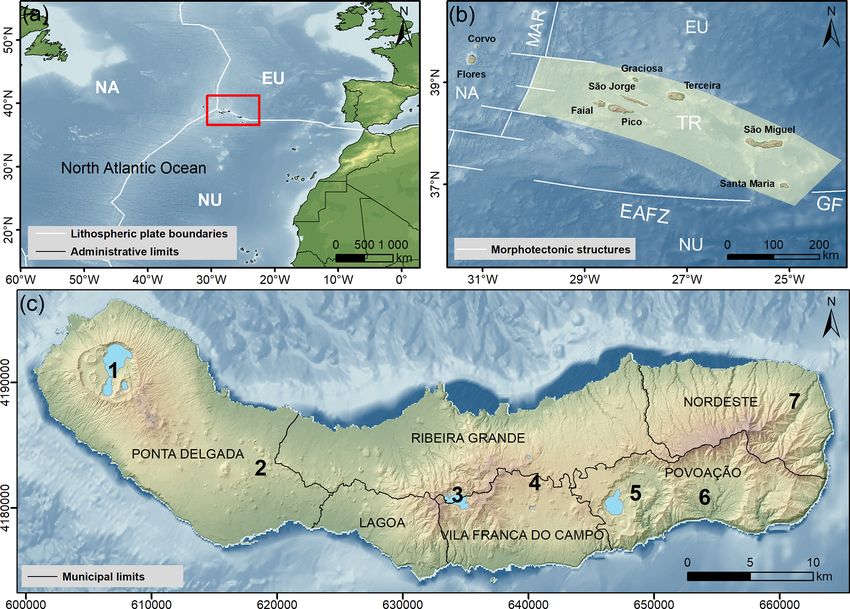
J. Medeiros et al.: Assessing the impact of explosive eruptions of Fogo volcano                                                419

namic point of view, this region corresponds to the triple         of trachytic pumice lapilli and ash fall layers (e.g. Walker
junction where the North American, Eurasian and Nubian             and Croasdale, 1971; Booth et al., 1978; Wallenstein, 1999;
lithospheric plates meet (Fig. 1a, b). Due to this partic-         Aguiar, 2018). The eruption started on 28 June in the cen-
ular geodynamic framework, the archipelago is subject to           tre of the caldera, on a previously existing cone (know as
frequent seismic and volcanic activity (e.g. Gaspar et al.,        Pico da Lagoinha or Pico das Berlengas) (Frutuoso, 1981).
2015b).                                                            The first phase was hydromagmatic and was followed by a
   São Miguel Island is formed by three active central volca-      sub-Plinian eruptive column with repeated hydromagmatic
noes – Sete Cidades, Fogo and Furnas – linked by Picos and         pulses. Tephra was mostly dispersed to the eastern part of
Congro fissure volcanic systems. The eastern part of the is-       the island due to the strong west-south-west-blowing wind
land comprises the older and inactive Povoação volcano and         (Walker and Croasdale, 1971; Wallenstein, 1999; Aguiar,
Nordeste volcanic system (Fig. 1c). All three active central       2018). The eruptive activity lasted 5 d and ceased on 3 July;
volcanoes are truncated by summit calderas related to parox-       4 d after the onset of the sub-Plinian eruption, a basaltic flank
ysmal explosive eruptions. In the last 5000 years at least 33      eruption occurred on Pico Queimado dome (then called Pico
sub-Plinian eruptions and one Plinian eruption are known to        do Sapateiro), on the north flank of Fogo volcano. A subse-
have occurred on São Miguel (Pacheco et al., 2013; Gaspar          quent phreatic explosion was also reported inside the caldera
et al., 2015a).                                                    on 10 February 1564 (Frutuoso, 1981; Wallenstein et al.,
   Located in the central part of São Miguel, Fogo volcano         2015; Aguiar, 2018).
(also known as Água de Pau volcano) is the largest of the             The present study area, Vila Franca do Campo municipal-
three active central volcanoes of the island, reaching a max-      ity, is located on the southern flank of Fogo volcano, and it
imum altitude of 947 m above sea level. The 3.2 km wide            borders with Lagoa municipality to the west, Ribeira Grande
summit caldera was formed by several collapse events and           to the north and Povoação to the east. To the south it is
is presently occupied by a lake. Several volcanic structures       bounded by the ocean in a costal extension of 15.5 km. Vila
are present inside the caldera (lava domes, pumice and tuff        Franca do Campo has an area of 77.9 km2 and is divided in
cones) as well as on the northern and southern flanks of the       six parishes: Água d’Alto, São Pedro, São Miguel, Ribeira
volcano (lava domes, scoria and pumice cones) (Wallenstein,        Seca, Ribeira das Tainhas and Ponta Garça (Fig. 2).
1999; Wallenstein et al., 2015).
   The stratigraphy of Fogo volcano is divided into two major
lithostratigraphic units (Wallenstein, 1999; Wallenstein et al.,   3     Methodology
2015): the Lower Group, which comprises all volcanic prod-
                                                                   3.1    Definition of the eruptive scenarios
ucts older than 40 ka, and the Upper Group, which includes
all products emitted in the last 40 kyr, including from the his-   The first step in the assessment of the impact of future ex-
torical eruptions. The recent eruptive period was marked by        plosive eruptions of Fogo volcano on São Miguel Island was
at least two paroxysmal explosive eruptions of Plinian di-         to define the eruptive scenarios. Based on the recent geolog-
mensions: the Ribeira Chã eruption (8000–12 000 years ago)         ical record of Fogo volcano (last 5000 years) and the fre-
and the Fogo A eruption (∼ 4600 years ago). In particular,         quency and magnitude of past trachytic explosive eruptions,
the last 5000 years were characterised by five sub-Plinian         two scenarios were defined: the most probable scenario (i.e.
eruptions: Pisão and Fogo B, C, D and 1563 (historic).             the most likely eruption) and the worst-case scenario (i.e.
   Fogo A was one of the largest eruptions recorded on São         the largest-magnitude eruption), in agreement with previous
Miguel. Its deposit encompasses a complex and widespread           studies (e.g. Gaspar et al., 2015a). The most probable sce-
succession of trachytic pyroclastic products emitted from the      nario is a sub-Plinian eruption with VEI 4, similar to the Fogo
summit caldera (e.g. Walker and Croasdale, 1971; Booth et          1563 eruption. Such an eruption would produce widespread
al., 1978; Bursik et al., 1992; Wallenstein, 1999; Pensa et        tephra fallout and could also generate PDCs in proximal ar-
al., 2015a, b). The eruption started with a short-lived hy-        eas, although this was not the case of the 1563 eruption. The
dromagmatic phase, followed by a Plinian eruptive column           worst-case scenario is a Plinian eruption with VEI 5, sim-
that produced a major pumice fall deposit. The radial and          ilar to the Fogo A eruption. Such an eruption would pro-
almost-symmetrical distribution of the fall deposit indicates      duce thick widespread tephra fallout and generate volumi-
that weak wind was blowing from the west during the erup-          nous PDCs along the flanks of the volcano.
tion. The eruptive column experienced partial collapses that          Taking into account that in the Azores region there are dif-
generated small-volume PDCs, and, in the final stage, the to-      ferences in the wind patterns of summer (May to September)
tal collapse of the column led to the emplacement of a volu-       and winter periods (October to April) (see wind statistical
minous ignimbrite, reaching > 20 m thick in Ribeira Grande         analysis in Pimentel et al., 2006; Cole et al., 2008; Gaspar et
graben (Wallenstein, 1999; Pensa et al., 2015a, b; Wallen-         al., 2015a), different tephra fallout scenarios should also be
stein et al., 2015).                                               considered for the two periods.
   The last sub-Plinian eruption of Fogo volcano occurred in
CE 1563. The deposit corresponds to a stratified succession

https://doi.org/10.5194/nhess-21-417-2021                                    Nat. Hazards Earth Syst. Sci., 21, 417–437, 2021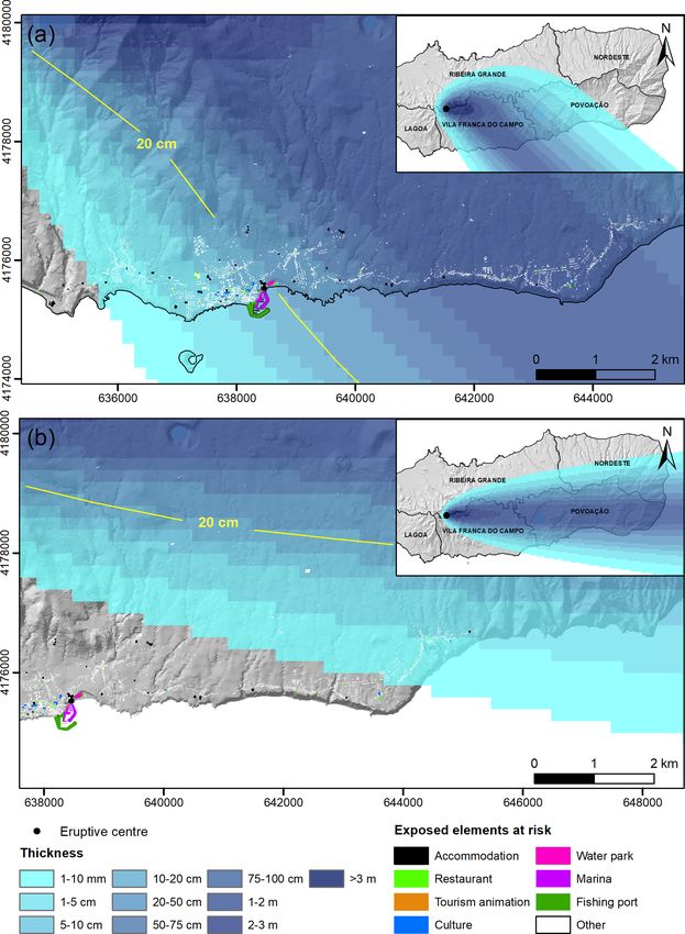
420                                             J. Medeiros et al.: Assessing the impact of explosive eruptions of Fogo volcano

Figure 1. (a) Location of the Azores archipelago in the North Atlantic Ocean and relation to the triple junction between the North American
(NA), Eurasian (EU) and Nubian (NU) lithospheric plates (world bathymetry and topography from the GEBCO_08 Grid; plate and country
boundaries from the Environmental Systems Research Institute, ESRI). Geographic coordinates: datum WGS 84. (b) Geodynamic setting of
the Azores archipelago and main morphotectonic structures of the region. MAR: Mid-Atlantic Ridge; TR: Terceira Rift; EAFZ: East Azores
Fracture Zone; GF: Gloria Fault (Azores bathymetry from EMODnet Bathymetry Consortium, 2018; morphotectonic structures modified
from Hipólito et al., 2010). Geographic coordinates: datum WGS 84. (c) Digital elevation model of São Miguel Island showing the volcanic
systems and administrative limits of the six municipalities: (1) Sete Cidades volcano, (2) Picos fissure volcanic system, (3) Fogo volcano, (4)
Congro fissure volcanic system, (5) Furnas volcano, (6) Povoação volcano, (7) Nordeste volcanic system (after Gaspar et al., 2015a). UTM
coordinates, zone 26S, datum WGS 84.

3.2     Numerical simulations                                                The eruptive source parameters used in the simulations
                                                                          were obtained from the literature related to the Fogo A and
To identify which areas of São Miguel are susceptible to be-              Fogo 1563 eruptions and, when unavailable, from published
ing affected by trachytic explosive eruptions of Fogo vol-                data of similar explosive eruptions. For the most probable
cano, the dispersion of tephra fallout and PDCs was simu-                 scenario (a VEI 4 sub-Plinian eruption), we considered a to-
lated using VORIS (Volcanic Risk Information System) ver-                 tal bulk volume of 1 km3 (Booth et al., 1978) and a column
sion 2.0.1 (Felpeto et al., 2007) implemented in a geographic             height of 18 500 m (Carey and Sparks, 1986). For the worst-
information system (GIS) (ArcGIS 9.1 ESRI® ). VORIS 2.0.1                 case scenario (a VEI 5 Plinian eruption), we used a total bulk
is a tool used in the assessment of volcanic hazards that pro-            volume of 3.2 km3 (Booth et al., 1978) and a column height
vides users with the necessary instruments for the production             of 27 000 m (Bursik et al., 1992). The simulations were con-
of scenarios and hazard maps.                                             ducted assuming a vent located in the centre of Fogo caldera.
                                                                          Eruptive input parameters are shown in Table 1.
3.2.1    Tephra fallout                                                      Wind parameters were compiled by Pimentel et
                                                                          al. (2006) from the Integrated Global Radiosonde Archive
Numerical simulations of tephra fallout were computed us-
                                                                          dataset of the National Centers for Environmental In-
ing an advection–diffusion model that assumes that above
                                                                          formation, formerly the National Climatic Data Center
the vent the mass is distributed along a vertical line following
                                                                          (https://www.ncdc.noaa.gov/data-access/weather-balloon/
the Suzuki approach (Suzuki, 1983). Far from the vent, the
                                                                          integrated-global-radiosonde-archive, last access: 8 Decem-
transport of particles is controlled by the advective effect of
                                                                          ber 2020), for the Lajes station, on the neighbouring island
the wind, the diffusion due to atmosphere turbulence and the
                                                                          of Terceira, between 1947 and 2003. Statistical analysis of
terminal settling velocity of the particles (see details in Folch
                                                                          56 years of radiosonde data revealed significant differences
and Felpeto, 2005; Felpeto et al., 2007).

Nat. Hazards Earth Syst. Sci., 21, 417–437, 2021                                            https://doi.org/10.5194/nhess-21-417-2021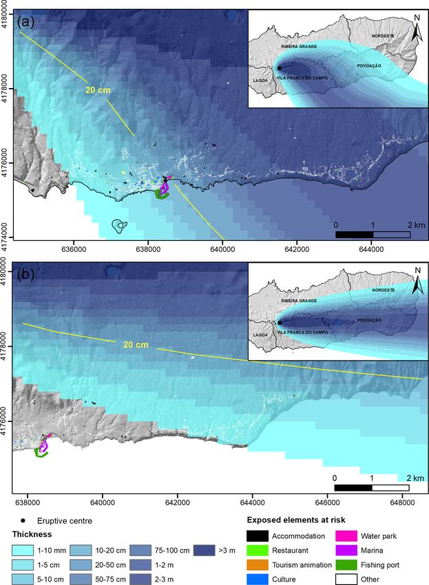
J. Medeiros et al.: Assessing the impact of explosive eruptions of Fogo volcano                                               421

Figure 2. Location of Vila Franca do Campo municipality (the study area) on São Miguel Island showing the six parishes, buildings,
infrastructure and main roads. UTM coordinates, zone 26S, datum WGS 84.

between summer (May to September) and winter periods               implies that the PDC can reach larger distances (Alberico et
(October to April). In the troposphere (and lower levels           al., 2008).
of the stratosphere, i.e. up to 17 000 m altitude), the most          Input parameters used in the simulations were collapse-
frequent directions in the summer period are between west          equivalent heights of 300 and 500 m (for VEI 4 sub-Plinian
and north-west and between north and north-west, whereas           and VEI 5 Plinian scenarios, respectively) and a constant
in the winter period the dominant trend is west to south-          collapse-equivalent angle of 6◦ , in agreement with previous
west-blowing winds. At higher altitudes (above 17 000 m), a        studies (e.g. Alberico et al., 2002, 2008, 2011; Cole et al.,
strong eastern direction prevails during the summer period,        2008). Both simulations were preformed assuming a source
while in the winter period a western direction dominates (Pi-      area equal to the floor of the caldera, where each 50 m cell
mentel et al., 2006; Gaspar et al., 2015a). The most probable      had an equal probability of generating PDCs.
combinations of wind direction and intensity were chosen
for different vertical heights according to the simulated          3.3   Exposed elements
column height. Wind input parameters are summarised in
Table 1.                                                           The vulnerability of buildings and infrastructure to different
   In total four tephra fallout scenarios were simulated:          volcanic products depends on the type of construction ma-
(1) VEI 4 sub-Plinian eruption during the summer period,           terials, the quality of the workmanship, the age and main-
(2) VEI 4 sub-Plinian eruption during the winter period,           tenance level, their shape, and orientation (Pomonis et al.,
(3) VEI 5 Plinian eruption during the summer period and            1999) but also on the loss of benefits from the activity for
(4) VEI 5 Plinian eruption during the winter period.               which they are intended. Thus, in the particular case of explo-
                                                                   sive eruptions, we considered the vulnerability of buildings
3.2.2   Pyroclastic density currents                               to tephra fallout and PDCs. In this study, we do not intend
                                                                   to assess the damage to the buildings but instead the loss of
Simulations of PDCs were performed with the energy cone            functionality.
model (Malin and Sheridan, 1982), which provides a fast and           To identify the exposed elements, a detailed inventory of
conservative approach to assessing the maximum potential           all buildings and infrastructure related to the tourism sector
extent of these volcanic products (e.g. Alberico et al., 2002,     in Vila Franca do Campo municipality was carried out dur-
2008; Felpeto et al., 2007; Toyos et al., 2007). The maximum       ing the summer of 2017. This followed a similar approach
potential extent of a PDC is directly related to the VEI of the    to the studies carried out by Pomonis et al. (1999) in Furnas
eruption and the topography around the vent. A higher VEI          parish and Gomes et al. (2006) in the parishes located on the

https://doi.org/10.5194/nhess-21-417-2021                                    Nat. Hazards Earth Syst. Sci., 21, 417–437, 2021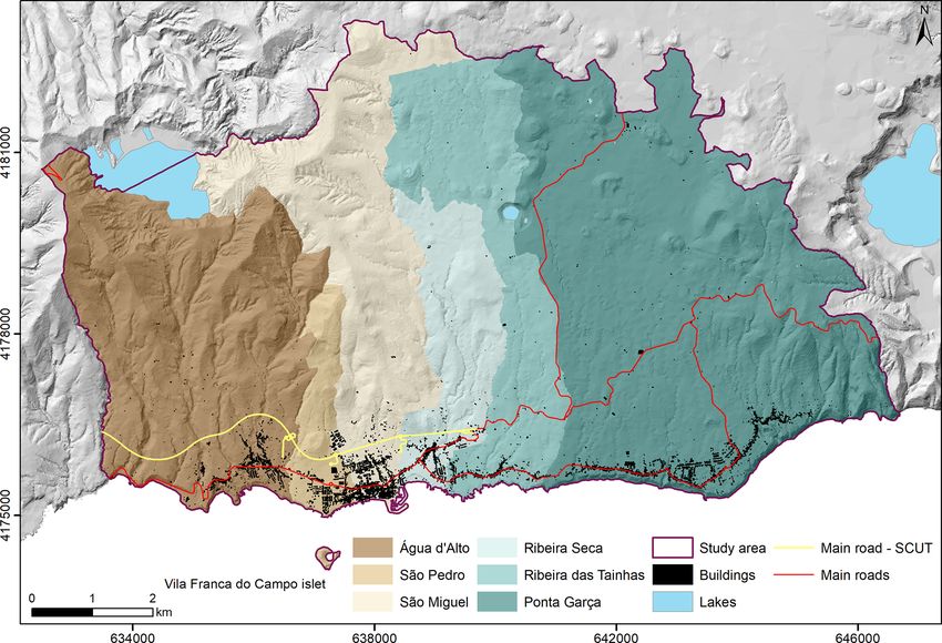
422                                             J. Medeiros et al.: Assessing the impact of explosive eruptions of Fogo volcano

Table 1. Input parameters used for the simulations of VEI 4 sub-Plinian and VEI 5 Plinian eruptions.

                      Eruptive source parameters                                         References
                      VEI 4 sub-Plinian          Bulk volume (km3 )                1     Booth et al. (1978)
                                                 Column height (m)            18 500     Carey and Sparks (1986)
                      VEI 5 Plinian              Bulk volume (km3 )               3.2    Booth et al. (1978)
                                                 Column height (m)            27 000     Bursik et al. (1992)
                      Grain size                 Mean diameter (Md8)              0      Cole et al. (1995)
                                                 Standard deviation (σ 8)         2      Cole et al. (1995)
                                                 Minimum (8)                      4      Walker and Croasdale (1971)
                                                 Maximum (8)                     −4      Walker and Croasdale (1971)
                      Clast density (kg m−3 )    Large (8  3)                 2300      Wilson and Huang (1979)

                          Wind conditions
                          VEI 4 sub-Plinian
                          Summer period         Altitude (m)          1500    6125      10 750   15 375    20 000
                                                Direction (◦ )         270     315         315      270        90
                                                Intensity (m s−1 )       8      17          20        8         6
                          Winter period         Altitude (m)          1500    6125      10 750   15 375    20 000
                                                Direction (◦ )         270     270         270      270       270
                                                Intensity (m s−1 )      17      20          20       17        11
                          VEI 5 Plinian
                          Summer period         Altitude (m)          1500    8125      14 750   21 375    28 000
                                                Direction (◦ )         270     315         270       90        90
                                                Intensity (m s−1 )       8      17          18        8        11
                          Winter period         Altitude (m)          1500    8125      14 750   21 375    28 000
                                                Direction (◦ )         270     270         270      270       270
                                                Intensity (m s−1 )      17      20          20       10        17

flanks of Sete Cidades volcano (São Miguel Island) and by               roof inclination, type of windows, etc. Details on the clas-
Cabral (2015) in Santa Catarina municipality (Fogo Island,              sification method can be found in Gaspar et al. (2004) and
Cape Verde).                                                            Gomes et al. (2006). The exposed elements (i.e. buildings
   The inventory included accommodation (hotels, guest                  and infrastructure associated with tourism in Vila Franca do
houses, rural tourism, local accommodations), restaurants               Campo) were mapped in detail in a GIS.
(ice cream shops, pastry shops, cafes, pubs), tourism an-                  The inventoried elements were then combined with the
imation and activities (travel agencies, rent-a-cars, nauti-            maps resulting from the different numerical simulations of
cal and terrestrial activities, souvenirs shops), and culture           tephra fallout and PDCs. This allowed us to identify which
(churches and places of cult, museums, libraries, theatres,             buildings and infrastructure would be affected by a certain
marketplaces, cultural centres).                                        thickness of tephra as well as those located within the maxi-
   Although this study does not intend to assess building               mum potential extent of PDCs.
damage but rather its loss of functionality, the inventory was
based on a classification method developed by the Centre for            3.4    Economic value of tourism
Volcanology and Geological Hazards Assessment (CVARG)
of the University of the Azores, now the Research Insti-                The methodology used to assess the impact of future explo-
tute for Volcanology and Risk Assessment (IVAR), to study               sive eruptions of Fogo volcano on the tourism economy con-
building vulnerability to different geological hazards in the           sists of evaluating the benefits generated by the accommoda-
Azores. This method classifies buildings according to use,              tion units of Vila Franca do Campo municipality. With that
number of floors, type of materials used in the construction,           aim, we determined the current loss of revenue over a period
                                                                        of 30 years for different eruptive scenarios and discount rates

Nat. Hazards Earth Syst. Sci., 21, 417–437, 2021                                            https://doi.org/10.5194/nhess-21-417-2021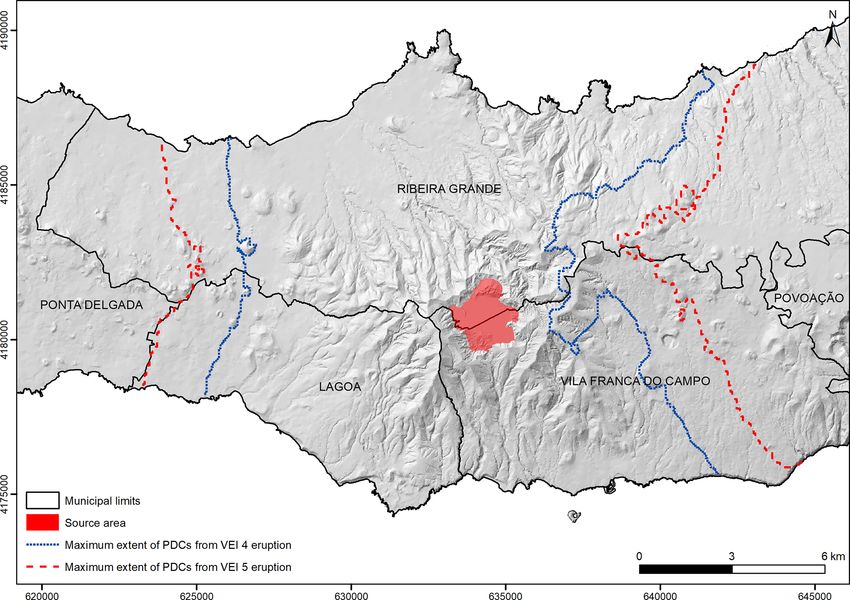
J. Medeiros et al.: Assessing the impact of explosive eruptions of Fogo volcano                                                423

and considered the evolution of the occupancy rate of the ac-      of the accommodation units was calculated for these three
commodation capacity. This study follows the approach pro-         scenarios.
posed by Vianna et al. (2012) that quantifies the value of a          The next step was to calculate the loss present value (LPV)
tourism industry based on shark diving in the Republic of          for each of the economic scenarios. The LPV corresponds to
Palau (Pacific Ocean), one of the main activities that con-        the value lost (in euros) after a certain period of time, dis-
tributes to the country’s economy.                                 counted to the initial period (2018), which corresponds to
   In the present case and following the building inventory,       year 0 (t0 ), following the expression
we calculated the annual income of 46 accommodation units                  Xti Rt
by estimating the average price per night of each unit. To         LPV =         t0 (1 + r)t
                                                                                             ,                                 (1)
calculate this value, we considered the price of one night in
March 2018 (low season) and the cost of one night in Au-           where t is the year (0 to i); Rt is the revenue of the accom-
gust 2018 (high season). Some of the costs were obtained           modation units in year t, taking into account the occupancy
directly, provided by a representative of the accommodation        rate; and r is the discount rate.
unit, while others were obtained indirectly through online            The occupancy rate (ro) is the percentage of occupied
booking and shopping platforms as well as through the es-          units or rooms in a certain area during a specific period. The
tablishments’ own websites. In specific cases, when it was         discount rate (r) is an intertemporal preference rate that al-
not possible to obtain this information, an average cost was       lows the conversion of future values into present values and
calculated considering the type of accommodation.                  accounts for the notion that a given monetary amount does
   The annual revenue was obtained by multiplying the av-          not have the same value in the present and in the future. A
erage cost per night by 365 d for the cases where the rent         discount rate equal to 0 is used when it is intended to give the
corresponds to the entire accommodation building. For the          same weight to future and present values in a long-term anal-
cases where the rent corresponds to only one room (e.g. ho-        ysis. This rate is considered a critical element in cost–benefit
tels, apartments or chalets), the average cost of one room was     analysis when costs and benefits accrue over a number of
multiplied by 365 d and by the number of rooms of the ac-          years. The social discount rate is used when examining costs
commodation unit. The total annual revenue of the tourism          of benefits accruing by society, and its value has been cal-
sector in Vila Franca do Campo at 2018 values was obtained         culated by researchers or sometimes externally proposed by
by adding up the annual revenues of each of the 46 accom-          government agencies for purposes of project or even environ-
modation units. However, this total revenue presupposes an         mental loss evaluation (Courard-Hauri et al., 2020). Evans
occupancy rate of 100 % of the existing accommodation ca-          and Sezer (2004) propose discount rates for six major coun-
pacity. To consider a more realistic situation, the total annual   tries ranging between 3.5 % (France) and 5 % (Japan). Evans
revenue was multiplied by a factor of 0.5 and 0.65 to assume       and Sezer (2005) argue that social discount rates in Euro-
an occupancy rate of 50 % and 65 %, respectively. This cre-        pean Union member countries mostly lie in the range of 3 %
ates two alternative scenarios for the existing accommoda-         to 5.5 %, while Florio and Sirtori (2013) estimate a set of val-
tion capacity (explained later on).                                ues ranging from 1.13 % (Italy) to 6.52 % (Estonia). For Por-
   To calculate the economic loss in Vila Franca do Campo          tugal, Florio (2006) estimates a 4 % discount rate, and Florio
municipality due to future explosive eruptions, we consid-         and Sirtori (2013) suggest 1.67 %. According to the Official
ered three economic scenarios resulting from the numerical         Journal of the European Union (2006), in 2006 the discount
simulations: (1) destruction of accommodation buildings af-        rate in Portugal should vary between 3.70 % and 4.62 % (Jan-
fected by ≥ 20 cm of tephra fallout from a VEI 4 sub-Plinian       uary to December, respectively).
eruption during the summer period, (2) destruction of ac-             In this study, we considered a period of 30 years for the
commodation buildings located within the maximum poten-            analysis, following the example of the eruption of Soufrière
tial extent of PDCs generated by a VEI 4 sub-Plinian erup-         Hills volcano (Montserrat, Lesser Antilles) that started in
tion and (3) destruction of accommodation buildings located        1995. This eruption also occurred on an island and produced
within the maximum potential extent of PDCs generated by           tephra fallout, PDCs and lahars, with devastating conse-
a VEI 5 Plinian eruption.                                          quences that last until today, even after more than 2 decades.
   Economic scenarios 1 and 2 (tephra fallout and PDCs, re-        Currently Montserrat’s tourism industry is still in a recovery
spectively) from a VEI 4 sub-Plinian eruption are more con-        phase (Pacheco and Lewis-Cameron, 2010). The LPV was
servative and realistic in case of a future explosive eruption     calculated for each of the chosen economic scenarios, con-
of Fogo volcano. Regarding tephra fallout, the summer pe-          sidering two occupancy rates of the existing accommodation
riod was chosen as it is the high season of touristic activity     capacity: one more conservative, with an occupancy rate of
but also because it corresponds to the wind conditions that        50 % and discount rates of 0 %, 2 % and 4 %, and another
would affect a larger portion of the study area. Economic          less conservative, considering that Azores tourism shows a
scenario 3 (PDCs from a VEI 5 Plinian eruption) is not the         growing tendency, with an occupancy rate of 65 % and the
most likely but represents the worst case possible, assuming       same discount rates (0 %, 2 % and 4 %). Discount rates be-
near-total destruction of the study area. The annual revenue       tween 2 % and 4 % lie in the range of values estimated for

https://doi.org/10.5194/nhess-21-417-2021                                   Nat. Hazards Earth Syst. Sci., 21, 417–437, 2021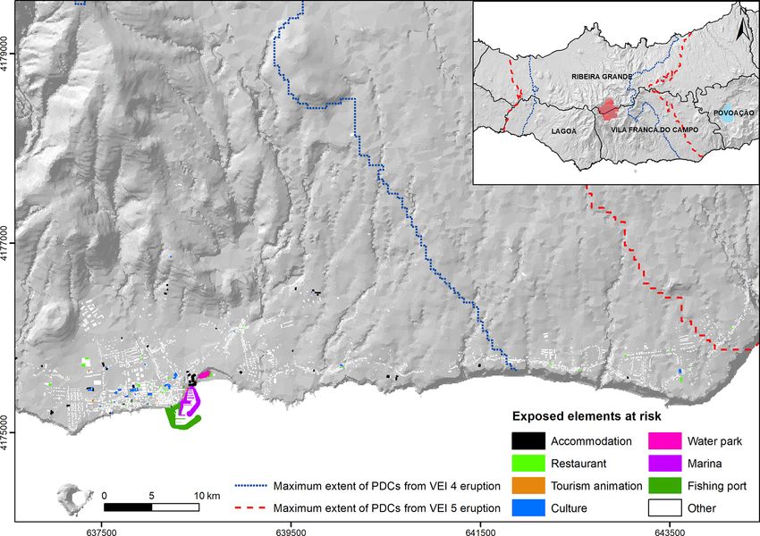
424 J. Medeiros et al.: Assessing the impact of explosive eruptions of Fogo volcano
Portugal and mentioned above. Moreover, the choice of two wind, tephra thicknesses of 1 to 3 m are deposited on much of
discount rates is also justified by the factors related to un- Povoação municipality, reaching > 3 m in the western part.
certainty. Moreover, the use of a higher (lower) discount rate Ribeira Grande and Nordeste municipalities are also affected
can be seen to some extent as a way of giving less (more) in their southern sectors, with thicknesses of 2 m to 1 mm,
weight to future and therefore uncertain (or risky) monetary from south to north.
flows associated with the touristic activity. Finally, the im-
pact of discounting can be assessed through comparison with 4.3 Pyroclastic density currents
a zero-discount baseline.
The simulations of PDCs for the VEI 4 sub-Plinian and VEI
5 Plinian eruptions (Fig. 5) show the maximum potential ex-
4 Numerical-simulation results tent of these volcanic products generated from within Fogo
caldera. In both cases, PDCs are not contained inside the
4.1 Tephra fallout from VEI 4 sub-Plinian eruption caldera and flow down the flanks of the volcano. The entire
central part of São Miguel may be affected by PDCs, which
The VEI 4 sub-Plinian simulation for the summer period
reach the sea on the north and south coasts. As expected, the
(Fig. 3a) shows that Vila Franca do Campo, located south-
VEI 4 and VEI 5 simulations differ in the maximum poten-
east of Fogo caldera, is the most affected municipality of São
tial extent that the PDCs can achieve. The VEI 4 simulation
Miguel, with > 3 m of tephra fall deposited in the caldera
(dotted blue line in Fig. 5) shows that the western half of
and immediately east-south-east of the vent. Almost all the
Vila Franca do Campo, most of Lagoa and the central part of
municipality is affected by tephra deposition up to 2 m thick.
Ribeira Grande municipalities are affected by PDCs, which
The predominant winds from the west-north-west also lead
can reach maximum distances of 9 km from the caldera. In
to the deposition of tephra on the western half of Povoação
the case of the VEI 5 simulation (dashed red line in Fig. 5),
municipality (between 50 cm and 1 mm, from west to east)
more than two-thirds of Vila Franca do Campo, all of Lagoa
and on the southern part of Ribeira Grande municipality (up
and the central part of Ribeira Grande municipalities are af-
to 3 m close to the caldera).
fected by PDCs that can reach maximum distances of 11 km
For the winter period (Fig. 3b), the prevailing winds from
from the source.
the west and the higher wind intensities promote the deposi-
tion of tephra on the eastern part of the island. Although Vila
Franca do Campo is located on the south-east flank of the
volcano, the strong westerly winds cause most of the tephra 5 Exposed elements at risk
to be deposited on the northern sector of the municipality,
with > 3 m immediately to the east of the caldera. However, The inventory and characterisation of buildings related to
in this scenario the entire Povoação municipality is affected tourism in Vila Franca do Campo municipality (140 in total)
by tephra fall that can reach maximum thicknesses of 1 to revealed that 46 correspond to accommodation units (33 %),
2 m in much of its area. Ribeira Grande and Nordeste munic- 51 correspond to restaurants (36 %), 29 are destined to cul-
ipalities are also affected in their southern sectors, although ture or cultural activities (21 %), and 14 buildings are related
with smaller thicknesses (1 m to 1 mm, from south to north). to tourism animation and activities (10 %) (Fig. 6). Infras-
tructure such as the marina, the fishing port and the water
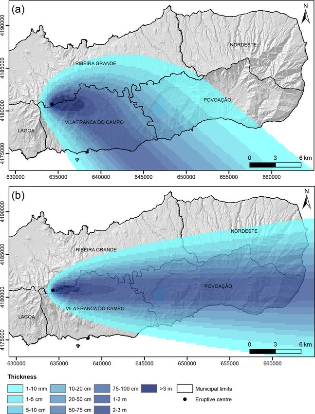
4.2 Tephra fallout from VEI 5 Plinian eruption park were also considered in the analysis.
The identification of the elements at risk was attained by
The VEI 5 Plinian simulations show the same dispersal pat- overlapping the mapped exposed elements (buildings and in-
terns of the VEI 4 sub-Plinian simulations described above frastructure) with the results of the simulations (Figs. 7 to
but with greater extents. For the summer period (Fig. 4a), 9). Regarding tephra fallout scenarios, it is important to dis-
Vila Franca do Campo municipality is the most affected, tinguish the type of destruction that the buildings can suffer
with > 3 m of tephra deposited on its northern part, east- depending on the tephra thicknesses. When a building (rep-
south-east of the caldera. Much of the municipality is af- resented by a polygon) was overlapped by more than one
fected by tephra deposition between 1 and 3 m thick. The thickness class we considered the most conservative option
neighbouring Povoação municipality is affected by tephra by choosing the class with the higher thickness. The impact
fall up to 1 m thick, particularly on the western side. The on the buildings was assessed according to the expected type
southern part of Ribeira Grande municipality is also affected of destruction following critical thickness thresholds.
by thicknesses of > 3 m of tephra close to the caldera. Buildings affected by 1 mm to 20 cm of tephra and sub-
For the winter period (Fig. 4b), the predominant stronger ject to constant and careful cleaning of the roof are usu-
winds blowing from the west lead to the deposition of tephra ally not damaged or may suffer only minor damage. For the
on the eastern part of São Miguel. Vila Franca do Campo is summer period (Figs. 7a and 8a), 62.1 % and 61.4 % (VEI 4
affected by thick tephra deposition (> 3 m) in the northern sub-Plinian and VEI 5 Plinian scenarios, respectively) of all
sector of the municipality. Given the higher intensities of the buildings related to tourism are likely to suffer thicknesses
Nat. Hazards Earth Syst. Sci., 21, 417–437, 2021 https://doi.org/10.5194/nhess-21-417-2021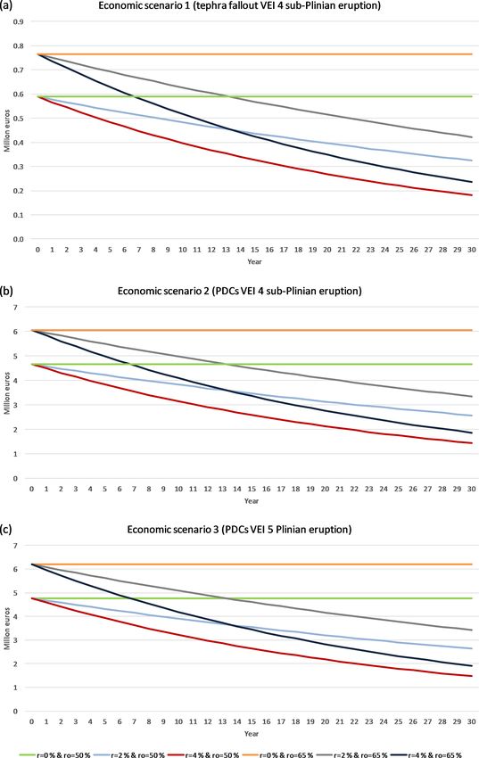
J. Medeiros et al.: Assessing the impact of explosive eruptions of Fogo volcano                                                    425

Figure 3. (a) Tephra fallout deposition from a VEI 4 sub-Plinian eruption of Fogo volcano, considering the dominant winds for the summer
period. (b) Tephra fallout deposition from a VEI 4 sub-Plinian eruption of Fogo volcano, considering the dominant winds for the winter
period. UTM coordinates, zone 26S, datum WGS 84.

of up to 20 cm. On the other hand, for the winter period              to suffer total collapse (Blong, 1984; Spence et al., 2005).
(Figs. 7b and 8b) buildings in Vila Franca do Campo mu-               For this case, the percentage of affected buildings is higher
nicipality will only be covered by a maximum of 5 cm of               in the VEI 5 Plinian scenario, with 19 %, whereas in the VEI
tephra. The affected buildings are located in Ponta Garça, the        4 sub-Plinian scenario it is 9.3 % (Table 2).
easternmost parish, and correspond to 5 % and 15 % (VEI 4                Concerning PDCs, it should be noted that the distinction
sub-Plinian and VEI 5 Plinian scenarios, respectively) of all         between dense and dilute currents was not taken into account
touristic buildings (see Table 2).                                    in this analysis, and therefore only total destruction was con-
   Buildings covered by ≥ 20 cm of tephra can suffer signif-          sidered. The percentage of tourism-related buildings located
icant damage, such as roof collapse (Pomonis et al., 1999).           within the maximum potential extent of PDCs (Fig. 9) from
For both summer scenarios (Figs. 7a and 8a), approximately            a VEI 4 sub-Plinian eruption is 87.1 %, whereas from a VEI
31 % of the buildings are in these conditions. In more ex-            5 Plinian eruption it is 95 %.
treme cases, buildings affected by ≥ 1 m of tephra are likely

https://doi.org/10.5194/nhess-21-417-2021                                       Nat. Hazards Earth Syst. Sci., 21, 417–437, 2021
426                                             J. Medeiros et al.: Assessing the impact of explosive eruptions of Fogo volcano

Figure 4. (a) Tephra fallout deposition from a VEI 5 Plinian eruption of Fogo volcano, considering the dominant winds for the summer
period. (b) Tephra fallout deposition from a VEI 5 Plinian eruption of Fogo volcano, considering the dominant winds for the winter period.
UTM coordinates, zone 26S, datum WGS 84.

Table 2. Percentage of buildings affected by tephra fallout from VEI 4 sub-Plinian and VEI 5 Plinian eruption scenarios in the summer and
winter period.

                   Tephra thickness                  Summer period scenarios                  Winter period scenarios
                                        Unaffected    1 mm–20 cm      20 cm–1 m     >1m      Unaffected    1 mm–5 cm
                   VEI 4 sub-Plinian    7.1 %         62.1 %          21 %          9.3 %    95 %          5%
                   VEI 5 Plinian        7.9 %         61.4 %          12 %          19 %     85 %          15 %

Nat. Hazards Earth Syst. Sci., 21, 417–437, 2021                                         https://doi.org/10.5194/nhess-21-417-2021
J. Medeiros et al.: Assessing the impact of explosive eruptions of Fogo volcano 427
Figure 5. Maximum potential extent of PDCs from a VEI 4 sub-Plinian eruption (dotted blue line; collapse height of 300 m) and from a VEI
5 Plinian eruption (dashed red line; collapse height of 500 m) of Fogo volcano. UTM coordinates, zone 26S, datum WGS 84.
nicipality was calculated considering three economic sce-
narios. The number of accommodation buildings affected in
each economic scenario is shown in Table 3.
The sum of the annual revenue of each accommodation
unit resulted in an estimated total annual revenue of approxi-
mately EUR 9.5 million, assuming that the accommodation
capacity was fully occupied. Combining the revenue data
with the chosen occupancy and discount rates allowed the
estimation of the LPV for a period of 30 years for each of the
economic scenarios (Fig. 10). Table 4 summarises the occu-
pancy rates (ro), discount rates (r) and LPV for the three
economic scenarios considered.
The graphs of Fig. 10 show that in all scenarios the LPV is
Figure 6. Percentage of buildings of each typology located in Vila
Franca do Campo municipality.
greater for higher occupancy rates and lower discount rates.
For example, in economic scenario 3 (PDCs from a VEI 5
Plinian eruption) the LPV after 30 years is almost EUR 145
million when the applied occupancy rate is 65 % and dis-
In addition to buildings, infrastructure related to the
count rate is 2 %. On the other hand, if an occupancy rate of
tourism sector in Vila Franca do Campo municipality will
65 % and a discount rate of 4 % are considered, the loss is
suffer similar damage to the buildings when affected by
approximately EUR 113 million. The lowest value of the up-
tephra fallout (summer period) and PDCs. Like the other ex-
dated loss is EUR 87 million for an occupancy rate of 50 %
posed elements, infrastructure will not be affected by tephra
and a discount rate of 4 %. In terms of LPV per year, there is
fallout in the winter period.
a decreasing trend over time in all scenarios. For economic
scenario 3 and considering both discount rates, the loss value
in year 0 does not reach EUR 5 million for occupancy rates
6 Assessment of the economic impact on tourism of 50 % and does not exceed EUR 6 million for a higher oc-
cupancy rate of 65 % (Fig. 10c). However, over the years the
The economic impact of future explosive eruptions of Fogo
LPV downward trend is more evident when a discount rate
volcano on the tourism sector of Vila Franca do Campo mu-
https://doi.org/10.5194/nhess-21-417-2021 Nat. Hazards Earth Syst. Sci., 21, 417–437, 2021428 J. Medeiros et al.: Assessing the impact of explosive eruptions of Fogo volcano
Figure 7. (a) Spatial distribution of the elements at risk in Vila Franca do Campo municipality (colour polygons) affected by tephra fallout
resulting from a VEI 4 sub-Plinian eruption at Fogo volcano, considering the dominant winds for the summer period. (b) Spatial distribution
of the elements at risk in Vila Franca do Campo municipality affected by tephra fallout resulting from a VEI 4 sub-Plinian eruption of Fogo
volcano, considering the dominant winds for the winter period. UTM coordinates, zone 26S, datum WGS 84.
Table 3. Number and percentage of buildings in each economic scenario.
Economic scenario Number of accommo- Percentage of accommo-
dation buildings dation buildings
(1) Tephra fallout VEI 4 sub-Plinian 17 36 %
(2) PDCs VEI 4 sub-Plinian 44 96 %
(3) PDCs VEI 5 Plinian 45 98 %
Nat. Hazards Earth Syst. Sci., 21, 417–437, 2021 https://doi.org/10.5194/nhess-21-417-2021J. Medeiros et al.: Assessing the impact of explosive eruptions of Fogo volcano 429 Figure 8. (a) Spatial distribution of the elements at risk in Vila Franca do Campo municipality (colour polygons) affected by tephra fallout resulting from a VEI 5 Plinian eruption of Fogo volcano, considering the dominant winds for the summer period. (b) Spatial distribution of the elements at risk in Vila Franca do Campo municipality affected by tephra fallout resulting from a VEI 5 Plinian eruption of Fogo volcano, considering the dominant winds for the winter period. UTM coordinates, zone 26S, datum WGS 84. is applied. For an occupancy rate of 65 %, the loss value in considered less realistic among economists and other agents, year 30 is EUR 1.9 million and EUR 3.4 million for discount its use might be important to assess the impact of discount- rates of 4 % and 2 %, respectively, while for an occupancy ing. As expected, this exercise yields the highest LPV in all rate of 50 %, this value is approximately EUR 1.4 million and economic scenarios (Table 4). For instance, regarding eco- EUR 2.6 million, considering discount rates of 4 % and 2 %, nomic scenario 3, LPV would amount to EUR 192 million at respectively. zero discounting and when a 65 % occupancy is applied. This The use of a discount rate equal to 0 % means that society means that, in such a case, discounting at 2 % and 4 % rates would attribute to a given monetary amount the same value reduces LPV by nearly EUR 47 million and EUR 79 million, in the future and in the present. Although this scenario is respectively. Other similar calculations can be performed, https://doi.org/10.5194/nhess-21-417-2021 Nat. Hazards Earth Syst. Sci., 21, 417–437, 2021
430                                           J. Medeiros et al.: Assessing the impact of explosive eruptions of Fogo volcano

Figure 9. Spatial distribution of the elements at risk in Vila Franca do Campo municipality (colour polygons) affected by PDCs resulting
from VEI 4 sub-Plinian (dotted blue line) and VEI 5 Plinian (dashed red line) eruptions of Fogo volcano. UTM coordinates, zone 26S, datum
WGS 84.

Table 4. Loss present value after 30 years for economic scenario 1 (tephra fallout VEI 4 sub-Plinian eruption), economic scenario 2 (PDCs
VEI 4 sub-Plinian eruption) and economic scenario 3 (PDCs VEI 5 Plinian eruption), considering discount rates of 0 %, 2 % and 4 % and
occupancy rates of 50 % and 65 %.

                     Economic scenario                      Occupancy rate (ro)    Discount rate (r)   LPV (euros)
                     (1) Tephra fallout VEI 4 sub-Plinian   50 %                   0%                   18 239 551
                                                                                   2%                   13 765 834
                                                                                   4%                   10 762 532
                                                            65 %                   0%                   23 711 416
                                                                                   2%                   17 895 584
                                                                                   4%                   13 991 291
                     (2) PDCs VEI 4 sub-Plinian             50 %                   0%                  144 556 924
                                                                                   2%                  109 100 634
                                                                                   4%                   85 298 067
                                                            65 %                   0%                  187 924 002
                                                                                   2%                  141 830 825
                                                                                   4%                  110 887 487
                     (3) PDCs VEI 5 Plinian                 50 %                   0%                  147 725 124
                                                                                   2%                  111 491 752
                                                                                   4%                   87 167 513
                                                            65 %                   0%                  192 042 662
                                                                                   2%                  144 939 278
                                                                                   4%                  113 317 767

Nat. Hazards Earth Syst. Sci., 21, 417–437, 2021                                        https://doi.org/10.5194/nhess-21-417-2021
J. Medeiros et al.: Assessing the impact of explosive eruptions of Fogo volcano 431 Figure 10. Loss present value after 30 years for (a) economic scenario 1 (tephra fallout VEI 4 sub-Plinian eruption), (b) economic scenario 2 (PDCs VEI 4 sub-Plinian eruption) and (c) economic scenario 3 (PDCs VEI 5 Plinian eruption), considering discount rates of 0 %, 2 % and 4 % and occupancy rates of 50 % and 65 %. https://doi.org/10.5194/nhess-21-417-2021 Nat. Hazards Earth Syst. Sci., 21, 417–437, 2021
432                                          J. Medeiros et al.: Assessing the impact of explosive eruptions of Fogo volcano

namely for economic scenarios 1 and 2, based on the values            The impact of tephra fallout on buildings and infrastruc-
included in Table 4.                                               ture will depend on the thickness of accumulated tephra,
                                                                   which is translated as static load. In localities affected by
                                                                   the accumulation of 20 cm or more of tephra, such as those
7     Discussion                                                   in the central and eastern parts of Vila Franca do Campo,
                                                                   buildings would suffer significant damage. While in local-
7.1    Impact of tephra fallout and PDCs from Fogo
                                                                   ities where the 1 m threshold is exceeded, such as Ponta
       volcano
                                                                   Garça in the summer period, buildings would likely suffer
Fogo volcano is considered one of the most hazardous vol-          total collapse, including constructions reinforced with con-
canoes in the Azores archipelago. Despite the low eruptive         crete (Blong, 1984; Spence et al., 2005). However, if tephra
frequency of sub-Plinian and Plinian eruptions, with a re-         is wet these critical thickness thresholds are substantially re-
currence interval of 833 years (Gaspar et al., 2015a), Fogo        duced (Spence et al., 2005). This possibility should not be
volcano produced the largest eruption in the Azores in the         overlooked given the rainy Azorean climate (Hernández et
last 5000 years (Fogo A) and one of the most recent ex-            al., 2016).
plosive eruptions of the archipelago (Fogo 1563) (Walker              Other elements such as the ground transportation network
and Croasdale, 1971; Booth et al., 1978; Wallenstein, 1999).       would also be affected by tephra fallout. As the main roads
Even in non-eruptive periods, Fogo volcano is a hazardous          of Vila Franca do Campo are located in the southern part of
landform with significant seismicity (Silva et al., 2015, 2020)    the municipality, they are mostly vulnerable to the accumu-
and geothermal activity, manifested in fumarolic fields, ther-     lation of tephra fall deposits during the summer period. Ma-
mal and cold CO2 -rich springs, and diffuse degassing areas        rine transportation can also be affected by tephra fallout as
(Viveiros et al., 2015). Several unrest episodes have occurred     ports and marinas become inoperable. Particularly during the
in the last 20 years, with intense earthquake swarms lasting       summer period, marine operations along the south coast of
for several months and accompanied by ground deformation           São Miguel would be severely affected, and important fish-
(inflation episodes), such as in May–September 2005 (Wal-          ing ports, such as Vila Franca do Campo, would be brought
lenstein et al., 2007; Silva et al., 2012). Due to its location,   to a halt.
in the central part of São Miguel, a future explosive eruption        The simulations of PDCs for VEI 4 sub-Plinian and VEI 5
of Fogo volcano will severely impact the parishes located on       Plinian eruptions show that these currents are not contained
the flanks of the volcano but also others in more distal areas     inside the caldera but are able to overcome the caldera walls
depending on wind conditions. Such an eruption will have           and flow down the flanks of the volcano. The eruption of such
significant long-term economic consequences for the island         volcanic products would affect the entire central part of São
and even for the entire Azores archipelago. Next, we discuss       Miguel, reaching the sea on the north and south coasts of
the impact of tephra fallout and PDCs on São Miguel follow-        the island. The maximum potential extent of the PDCs is of
ing the eruptive scenarios defined in this study.                  the order of 9 and 11 km from the caldera for the VEI 4 and
   The simulation of tephra fallout from a VEI 4 sub-Plinian       VEI 5 scenarios, respectively. It should be noted that in the
eruption (most probable scenario) during the summer period,        case of a real event, the progression of PDCs is strongly con-
shows that the prevailing winds blowing from the west-north-       trolled by topography and channelled through valleys and de-
west promote the deposition of tephra within the caldera           pressions along the flanks of the volcano. Validation of these
and to the east-south-east of the vent, making Vila Franca         simulations can be done by comparison with the geologi-
do Campo municipality the most affected, with tephra de-           cal record of PDC deposits. Fogo A ignimbrites were em-
position up to 2 m thick. For an eruption occurring during         placed quasi-radially outward from the caldera, within nar-
the winter period, the predominant winds blowing from the          row palaeo-valleys on the southern flank and along Ribeira
west and the higher wind intensities lead to the deposition of     Grande graben on the northern flank, reaching the sea in both
tephra on the eastern part of the island. Validation of the sim-   cases (see distribution maps of the Fogo A ignimbrites in
ulation results can be made by comparison with the geolog-         Pensa et al., 2015a, b).
ical record, namely with the deposit of the Fogo 1563 erup-           The impact of PDCs on buildings and infrastructure is
tion, which has a well-defined dispersal axis towards the east     mostly related to their dynamic pressure and temperature.
(see the isopach map of the Fogo 1563 deposit in Fig. 20 of        However, in this case we do not distinguish between dense
Walker and Croasdale, 1971). Regarding tephra fallout from         and dilute currents and assumed a binary-impact approach,
a VEI 5 Plinian eruption (worst-case scenario), the simula-        which considered the absence of damage or total destruction
tion results show the same dispersion patterns as the VEI 4        of buildings and infrastructure by PDCs. Ground and marine
sub-Plinian eruption scenario for summer and winter condi-         transportation networks are also highly vulnerable to PDCs
tions, though with thicker tephra deposition due to the larger     as roads, ports and marinas would become buried or suffer
volume of ejected material.                                        irreparable heat damage.

Nat. Hazards Earth Syst. Sci., 21, 417–437, 2021                                    https://doi.org/10.5194/nhess-21-417-2021
J. Medeiros et al.: Assessing the impact of explosive eruptions of Fogo volcano 433
7.2 Impact of explosive eruptions on the economy of economy were estimated using only the values from the ac-
tourism of Vila Franca do Campo commodation units of Vila Franca do Campo municipality.
To achieve a more realistic estimation of the total revenue
The main economic activities in the Azores are public ser- related to the tourism economy, the benefits of other sec-
vices, retail and wholesale trade, fishing, livestock ranch- tors, such as restaurants or tourism animation and activities,
ing, and production of dairy products (Vieira et al., 2019). should also be considered. The tourism industry also con-
Tourism is a growing and promising activity for job creation tributes to the economy by generating jobs in hotels, guest
and for the development of this archipelago, where the land- houses, local accommodations, restaurants, souvenir shops,
scape and marine-related activities constitute the main attrac- etc., and therefore the workers’ salaries should also be quan-
tions (Calado et al., 2011; Torres et al., 2017; Vieira and An- tified. Indirect losses should also be accounted for, such as a
tunes, 2017). From 2001 to 2018, there has been an almost drop in the consumption of fish, dairy or beef products in the
constant increase in jobs related to tourism in the Azores. In food sector, thus affecting the economy of other sectors such
2015 tourism employed 11 847 people, and in 2018 it reached as agriculture and sea. Nevertheless, the present methodol-
19 614 people. These values give a good indication of the im- ogy may be adopted to calculate the loss of revenue of other
portance that this sector has assumed, growing to represent sectors related to tourism and also applied to different vol-
approximately 20 % of all employment in the Azores (For- canic regions vulnerable to explosive volcanism.
tuna et al., 2020). The number of visitors sharply expanded
after the liberalisation of airspace in two corridors between
the mainland and the Azores since 2015, which allowed the 8 Conclusions
entrance of low-cost airlines (Vieira et al., 2019). According
This study presents a new approach to quantifying the im-
to satellite tourism accounts, tourism accounted for 6.7 % of
pact of explosive volcanic eruptions on the tourism industry.
the gross value added (GVA). At the same time, the consump-
We determined the economic loss related to future explosive
tion of goods and services by tourists amounted to 14.1 % of
eruptions of Fogo volcano (São Miguel Island) by estimating
the GDP (SREA, 2018).
the benefits generated by the accommodation units of Vila
The location of Vila Franca do Campo municipality in
Franca do Campo municipality.
the southern part of São Miguel Island, approximately 20 km
Two eruptive scenarios were considered for Fogo volcano:
east of Ponta Delgada city (the island’s capital), together with
the most probable scenario (a VEI 4 sub-Plinian eruption)
its moderate climate and numerous bathing areas along the
and the worst-case scenario (a VEI 5 Plinian eruption). We
coast, attracts many tourists throughout the year. Therefore,
evaluated the vulnerability of tourism-related buildings and
tourism is a major source of revenue for this municipality.
infrastructure in Vila Franca do Campo to tephra fallout
In 2018, the estimated total annual revenue of the accom-
and PDCs by analysing their loss of functionality. The loss
modation units on Vila Franca do Campo was approximately
present value (LPV) method was used to estimate the bene-
EUR 9.5 million (assuming that the accommodation capacity
fits generated by the accommodation units for different eco-
would be fully occupied). This figure clearly shows the im-
nomic scenarios.
portance of this sector on the economy of the municipality
The simulations show that tephra deposition from a VEI
and of the entire island of São Miguel.
4 sub-Plinian eruption during the summer period occurs to
Looking at the calculated LPV for a period of 30 years
the east-south-east of Fogo caldera, while during the winter
for each economic scenario, we can conclude that this value
period the deposition is to the east of the caldera. For a VEI
is greater when the occupancy rate is higher, and the dis-
5 Plinian eruption the dispersion patterns are similar but with
count rate is lower. Economic scenario 1 (tephra fallout from
a larger dispersion area and thicker tephra deposition. The
a VEI 4 sub-Plinian eruption during the summer period) has
simulations of PDCs show that the central part of São Miguel
the smallest LPVs for the different rates used. The other
is the most affected as currents flow down the flanks of the
two economic scenarios (PDCs from a VEI 4 sub-Plinian
volcano, reaching the sea on both coasts.
eruption and from a VEI 5 Plinian eruption) have similar
The assessment of the economic impact on the tourism
LPVs because they comprise 96 % and 98 % of the accom-
sector shows that economic scenario 1 (tephra fallout from a
modation buildings, respectively (Table 3). Still, and as ex-
VEI 4 sub-Plinian eruption) has the lowest LPV when com-
pected, economic scenario 3 represents the higher loss, al-
pared to economic scenarios 2 and 3 (PDCs from VEI 4
most EUR 145 million (Table 4). As seen in Fig. 10, the LPV
sub-Plinian and VEI 5 Plinian eruptions, respectively), which
shows a decreasing trend over the years as a result of the ap-
have similar LPVs. Although economic scenario 3 is not
plied methodology, except when the discount rate of 0 % is
the most likely as it represents near total destruction of Vila
applied as it causes LPV to remain constant over time.
Franca do Campo municipality, it corresponds to the higher
The method used in this study is a first attempt to quantify
economic loss, with approximately EUR 145 million over
the economic loss of the tourism sector resulting from future
30 years.
explosive eruptions of Fogo volcano. It should be noted that
both the annual revenue and the LPV obtained for the tourism
https://doi.org/10.5194/nhess-21-417-2021 Nat. Hazards Earth Syst. Sci., 21, 417–437, 2021You can also read