Decentralised Drone Platform - soar.earth
←
→
Page content transcription
If your browser does not render page correctly, please read the page content below

Decentralised Drone Platform
       Whitepaper - Version 1.6

                                  soar.earth
                                                                 1/29
               Soar reserves the right to change this document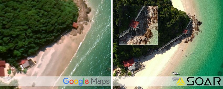
Executive Summary                                                   8

1. Soar Vision                                                     10

 1.1 The Soar Opportunity                                          10

 1.2 Why Does Soar Use A Blockchain?                               10

 1.3 Origins of Soar Technology                                    11

 1.4 The Growing Drone Market                                      12

2. The Soar Solution                                               16

 2.1 Skymap Tokens                                                 16

 2.2 The Soar Quadtree                                             16

 2.3 The Soar Marketplace                                          17

  2.3.1 Soar Content Price Calculations                            18

  2.3.2 Types of Data and Metadata                                 19

 2.4 Soar Product Prototype                                        22

 2.5 SkyBounty System                                              24

 2.6 SkySponsor Model                                              25

  2.6.1 SkySponsor Model: Market Traction Solution                 25

  2.6.2 SkySponsor Model: Quality Assurance & Content Moderation   26

  2.6.3 SkySponsor Model: Business Opportunity                     26

  2.6.4 SkySponsor Model: Offchain Cloud Storage                   26

 2.7 Drone Regulatory Compliance                                   27

 2.8 Intellectual Property                                         28

3. Go to Market Strategy                                           29

 3.1 Commercial Drone Operators                                    29

                                                                    2/48
3.2 Drone Enthusiasts                                               29

 3.3 Hardware & Software Providers                                   30

 3.4 Value-added Services                                            30

 3.5 Large Content Consumers                                         30

4. The Revenue Model                                                 32

 4.1 Commission Model                                                32

 4.2 Product Differentiation Model                                   32

 4.3 Integrated Services Model                                       33

5. End State: The Super-Map                                          36

6. The Token Generation Event (TGE)                                  38

 6.1 SKYM Token                                                      38

 6.2 SKYM Token Crowdsale                                            38

 6.3 Use Of Funds                                                    39

 6.4 Roadmap                                                         39

7. The Team                                                          40

 7.1 The Core Team                                                   40

 7.2 Advisors / Board Members                                        41

Investors & Partners                                                 42

Glossary43

Appendix A - Types of images suitable for use in the Soar platform   44

Appendix B - Drone Value Chain                                       46

References47

                                                                      3/48
List of Figures
Figure 1:    Soar’s military origins from tactical mapping applications                            11
Figure 2:    Breakdown of the $127 billion global market opportunity for drones                    12
Figure 3:    Projected growth estimates of the commercial drone market to 2025                     13
Figure 4:    Breakdown of the value of the global drone market by end users for estimates.         13
Figure 5:    Examples of industry applications of drone content that will be available on Soar     15
Figure 6:    Soar’s unique quadtree illustrating that images can sit within a grid at different
             resolutions                                                                           16
Figure 7:    An example of a heat map showing different levels of activity at a particular zoom
             level at a point in time                                                              17
Figure 8:    Forecasted price calculations of the Soar marketplace based on supply and
             demand of mapping content                                                             19
Figure 9.1: Google Maps imagery compared to the capabilities of the Soar platform. The
             differences in quality is compelling                                                  20
Figure 9.2: Google Maps imagery compared to the capabilities of the Soar platform. The
             differences in quality is compelling                                                  20
Figure 10: Multiple orthorectified images are stitched together to make an aerial map              21
Figure 11:   True color imagery compared to specialist sensors such as thermal imaging over
             farmland in eastern Australia                                                         21
Figure 12.1		Soar platform home page                                                               22
Figure 12.2:		Soar platform on mobile                                                              22
Figure 12.3:		Searching the database on the Soar platform                                          23
Figure 13:   The framework between the Soar SkyBounty system highlighting the utility of the
             SKYM token between the SkyBounty issuer and content provider                          24
Figure 14: How the SkySponsorship model works                                                      25
Figure 15: An example of how files are remotely stored by Soar                                     27
Figure 16: Infographic highlighting the regulatory compliances in Australia that drone
             operators must adhere to in-order to meetthe system requirements of the Soar          28
             platform
Figure 17.1: Comparison of high and low-resolution photographs - system requirements of the 32
             Soar platform
Figure 17.2: Comparison of high and low-resolution photographs - system requirements of the 33
             Soar platform
Figure 18: An example of night time thermal imagery                                                33
Figure 19: An example of automated object classification for parked cars within a geofenced
             area                                                                                  34
Figure 20: Vegetation analysis determining plant health in agriculture is an example of Soar’s
             integrated service model                                                              34

                                                                                                  4/48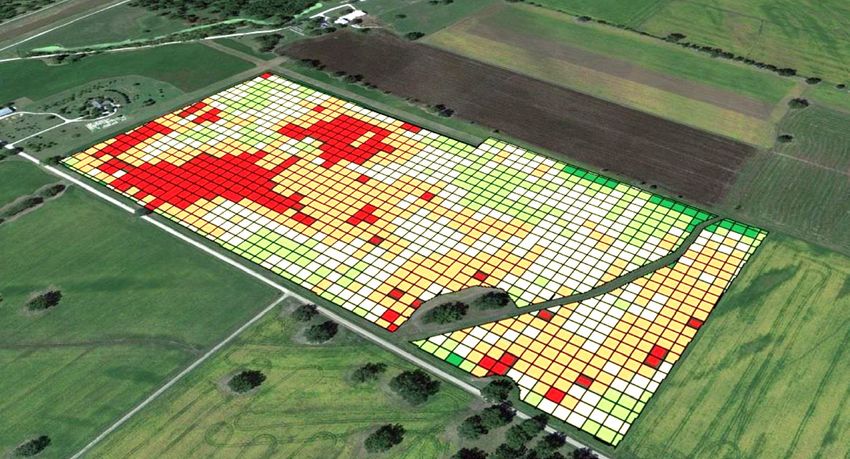
Figure 21: Soar’s Content Marketing model allows for trusted and verifiable drone image
           capture                                                                              35
Figure 22: The end-state Super-map schematic showing a dynamic, crowdsourced map of
           the world with compelling product types for almost all uses using blockchain
           technology                                                                           36
Figure 23: Planned use of the Soar funds                                                        39
Figure 24: The drone value chain, highlighting the sectors impacted by the launch of the Soar
           platform                                                                             46

List of Tables
Table 1:   Structure of the Soar TGE                                                            38
Table 2:   Soar platform roadmap                                                                39

                                                                                            5/48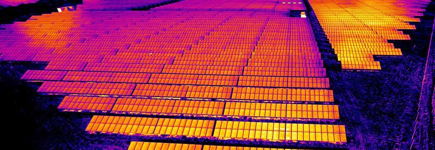
Disclaimer
This Whitepaper contains summary information about Soar SG Pte Ltd (“Soar”), and its
subsidiaries in various international jurisdictions as is current as at May 2018. The information
in this presentation is of general background and contains only an overview and summary of
certain data selected by the management of Soar. It does not purport to be complete.

This Whitepaper is not a prospectus, disclosure document or offering document under the law
of any jurisdiction. It is for informational purposes only. This presentation is not investment
or financial product advice (nor tax, accounting or legal advice) and is not intended to be used
for the basis of making an investment decision. A recipient must make their own independent
investigations, consideration and evaluation of Soar and the offer and Soar recommends that
investors should obtain their own professional advice before making any investment decisions
in Soar. An investment in Soar or SKYM is considered to be speculative in nature.

All currency amounts are in USD unless otherwise stated.

This document has been prepared based on information available at the time of presentation.
No representation or warranty, express or implied, is made as to the fairness, accuracy or
completeness of the information, opinions and conclusions contained in this presentation or
any omission from this presentation or of any other written or oral information or opinions
provided now or in the future to any person. While reasonable care has been taken to ensure
that facts stated in this presentation are accurate and/or that the opinions expressed are fair and
reasonable, no reliance can be placed for any purpose whatsoever on the information contained
in this document or its completeness.

To the maximum extent permitted by law, neither Soar nor, any affiliates, related bodies corporate
and their respective officers, directors, employees, advisors and agents, nor any other person,
accepts any liability as to or in relation to the accuracy or completeness of the information,
statements, opinions or matters (express or implied) arising out of, contained in or derived
from this presentation or any omission from this presentation or of any other written or oral
information or opinions provided now or in the future to any person.

Some of the statements appearing in this Whitepaper are in the nature of forward looking
statements. You should be aware that such statements are only predictions based on
assumptions, and are subject to inherent risks and uncertainties. Those risks and uncertainties
include factors and risks specific to the industry in which Soar operates as well as general
economic conditions, prevailing exchange rates and interest rates and conditions in the financial
markets and other factors that are in some cases beyond Soar’s control. As a result, any or all
of Soar’s forward-looking statements in this presentation may turn out to be inaccurate.

Actual events or results may differ materially from the events or results expressed or implied
in any forward looking statement. Neither Soar, or their officers or any person involved in the
preparation of this Whitepaper makes any representation or warranty (express or implied) as to
the accuracy or likelihood of fulfilment of any forward looking statement, or any events or results
expressed or implied in any forward looking statement, except to the extent required by law.
You are cautioned not to place undue reliance on any forward looking statement. The forward
looking statements in this presentation reflect Soar’s views as at the date of this Whitepaper.

To the maximum extent permitted by law, Soar and its related bodies corporate and the officers,
directors, employees, advisers and agents of those entities do not accept any responsibility or
liability including, without limitation, any liability arising from fault or negligence on the part of any
person, in relation to the accuracy or completeness of the information, statements, opinions or

                                                                                                        6/48
matters (express or implied) arising out of, contained in or derived from this presentation or any
omission from this presentation or of any other written or oral information or opinions provided
now or in the future to any person or for any loss arising from the use of the presentation or its
contents or otherwise arising in connection with it.

This Whitepaper does not constitute an offer of securities in Soar.

The Whitepaper is not for publication, distribution or release in or into the United States or to
any person located in the United States and does not constitute an offer to sell, or a solicitation
to buy, any securities in the United States.

                                                                                                 7/48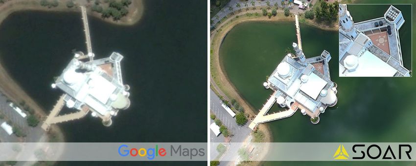
Executive Summary
   “Drones are already generating climate data, monitoring the borders and
  more - and they’re just scratching the surface of their commercial potential”
                                       - Goldman Sachs
Soar is a decentralised platform for high-quality drone content that connects customers with
content creators in a secure, trustless and distributed blockchain community.

The first stage of the implementation of Soar will be the creation of a marketplace for drone
content including still images, video, aerial maps and other specialist drone content. The Soar
marketplace will allow drone operators to upload and sell content to other Soar users anywhere
in the world. The Soar marketplace has the potential to allow an exponential increase in the
value of mapping data and drone content by realising the untapped financial potential of existing
drone content. Furthermore, by securing the integrity of drone content metadata via smart
contracts, Soar automatically and transparently publishes the location, time and equipment
type used to capture content onto the blockchain. The use of blockchain technology validates
the authenticity of the footage to ensure the integrity of drone content and fight the problems
such as ‘fake news’.

However, this is not the end-game. Progressively, by aggregating the content collected from
thousands of drone operators, Soar will in due course create a dynamic database for the world’s
first super-map at an unprecedented level of detail. All connected using blockchain technology
to share data.

Leveraging the expansion in drone usage by both business and consumers, Soar will provide
an opportunity for drone owners to monetise their content. Commercial drone sales in 2017
were expected to exceed US $1 billion1. The expanding drone market is largely driven by the
tremendous growth in commercial applications of drone content and footage in industries such
as infrastructure, mining, agriculture, journalism and real estate with an addressable market
estimated to reach $127 billion by 20202. The growth rates in the market have been estimated
to be between 15-25% CAGR over the next five years3, 4 .

Despite the rapid growth of the drone industry, there is an absence of a suitable marketplace
for drone content or facility for licensed drone operators to fully optimise and monetise their
content. Soar will directly address this lack of a market for content. Furthermore, there has not
been direct access to mapping technology which would allow this content to effectively seed
a super-map platform and take advantage of the extremely high-resolution content of which
drones are capable.

The Soar marketplace will allow:

ϷϷ Buyers to easily locate and buy drone content already on Soar;
ϷϷ Buyers to offer a SkyBounty on an area which rewards drone operators to upload content to
   match the SkyBounty needs; or
ϷϷ Drone operators to upload content under a SkySponsor arrangement for sale in an open
   market environment.

Soar will provide this platform for content providers and purchasers, transacting with the SkyMap
token (Symbol:SKYM), a utility token that unlocks a range of capabilities on the Soar Platform.
Owning SKYM tokens allows customers to utilise the platform and rewards the content creators.

                                                                                               8/48
The SKYM tokens unlock key features of the Soar platform by allowing the user to:

ϷϷ   Purchase drone content;
ϷϷ   Create SkyBounties for specific areas;
ϷϷ   Qualify individuals and organisations as a SkySponsor on the Soar platform; and
ϷϷ   Provide the economic initiative for the eventual seeding of the world’s first super-map.

Buying drone content from the Soar platform using SKYM is a simple process of browsing
and searching the Soar platform for the desired content and buying it with SKYM tokens. This
transaction is recorded on the blockchain.

Soar’s SkySponsor model allows for curation of the content as the SkySponsors will only support
content that is likely to be used, thereby increasing the overall content quality uploaded to Soar.

The driver for the SkySponsor model is extremely compelling as it effectively proves the
economics for seeding the Soar super-map. The super-map will be both dynamic and temporal;
over time it will evolve to only exhibit the ‘best of the best’ imagery. The basis of this super-map
is not limited to merely a simple blockchain application, rather, it will serve as the foundation
for an unprecedented mapping protocol to power other blockchain solutions which require
mapping and imagery inputs.

                                                                                                  9/48
1. Soar Vision

1.1 The Soar Opportunity
The Soar platform is tapping into an emerging market opportunity to become the leading
open marketplace for drone content including photo and video content. Currently, most drone
operators only use a single channel to sell their content: on commission from a customer.
Moreover, in many instances this content is limited to localised markets. This one-to-one
approach to sourcing drone content limits the opportunity for drone operators to resell to other
interested parties or organisations without it having to be re-flown.

The Soar platform’s approach will allow drone operators to potentially grow drone content
sale and monetisation to a global scale and unlock the potential value in underutilised drone
footage. With its unique approach to validation of the drone content, buyers know exactly where
and when drone content was collected and the blockchain technology ensures the integrity of
this information is easily verified.

The potential value creation of drone footage marketplace is challenged by the lack of
standardisation of content formats and the significant file size of high quality drone footage. As
Soar is compatible with a broad range of drone content file types, this removes the problem of
content format standardisation and its cloud based storage approach removes the problem of
localised storage and delivery and long download times.

Moreover, much of the valuable geospatial knowledge held within drone imagery and data today
remains unrecognised and unutilised for the vast majority of drone content creators. Hardware
metadata and other geospatial data relating to the location coordinates of the imagery and the
temporal components captured in existing drone imagery can potentially hold significant value
for a wide range of industrial and consumer applications. For example, amateur drone footage
taken of a beach on a family vacation could have significant commercial or research value for
scientists looking to study coastal erosion, pollution or vegetation loss.

1.2 Why Does Soar Use A Blockchain?
The decision for Soar to use the Blockchain can be summed up by the utility of the blockchain
in providing the verification and authenticity of drone content uploaded to Soar. By securing
the integrity of drone content metadata through its smart contracts, Soar automatically and
transparently publishes a range of data to the blockchain which includes:

ϷϷ   The file’s hash
ϷϷ   Location, date, altitude, type of drone used to collect the content
ϷϷ   Title, description, keywords and other information associated with the content
ϷϷ   Content storage address
ϷϷ   The wallet address of the drone operator
ϷϷ   The wallet address of the SkySponsor
ϷϷ   Sales transactions

When the blockchain technology is combined with Soar’s SkySponsor model (See Section 2.6),
Soar provides an immutable record of content creation and distribution and support for the
uploading of the content. The use of the blockchain to record drone metadata will prevent
problems identified with such issues as drone content becoming part of the current problem
with ‘fake news’.

                                                                                                10/48
1.3 Origins of Soar Technology
The strength of the Soar platform comes from almost a decade of development driven by the
core objective to democratise geospatial technology to any potential user. During this period,
the development team behind the Soar platform have launched several highly successful
commercial mapping applications that have empowered tens of thousands of users from over
80 countries in the collection, visualisation, and analysis of geospatial data.
The Soar platform has evolved from a military pedigree when, in 2015, the Soar team were
approached by the US Department of Defense to submit alternative mapping technologies on the
back of the growing number of US Marines and Army units that required geospatial applications
in tactical situations. The US military expressed interest in further developing this application so
that it could run on a warfighters mobile device such as a tablet and radically enhance real-time
geospatial awareness between tactical units in the field.
What followed was an intense vetting program involving tactical feature updates, security
clearances, rigorous scrutiny of the technology code and further development of encryption
coding. In 2017, the technology behind Soar successfully passed the military onboarding process
and was introduced into a closed application platform that was available only to US military
personnel.
During this time, working alongside the US Military, the original technology application
was enhanced through a combination of game-design, social media work-flows, industrial
psychology and some additional classified technologies. Many of the enhancements were
specifically designed to assist soldiers in unique tactical scenarios, but ultimately the result was
a sophisticated technology responsible for the standardisation and multilateral application of
geospatial data.
This technology of course also required the ability to enable all types of mapping imagery and
content to be made available to the user. This included drone, aerial, satellite, thermal and multi-
spectral imagery; all accessible via multiple inputs, offline and without storage limitations.
As of August 2017, the technology behind Soar was made available to commercial and civilian
applications. This technology has now been adapted to become not only the platform for the
Soar marketplace but also the foundation for the end-state which is a global super-map protocol.
Figure 1: Soar’s military origins from tactical mapping applications (Source: Takor Group).
11/481.4 The Growing Drone Market
Note: In this is document the following definition applies for the term ‘drone operator’: “Any
individual or organisation that has access to drone in a non-recreational role.” This definition
includes individuals who are licensed drone operators, through to businesses and larger
organisations which collect data as a service. Additionally, content creators can also be individuals
or community groups which maintain expertise in the operation of drones and distribution of
content collected by them.
The Soar marketplace has been designed to tap into a need within the growing drone industry.
The market for consumer and commercial drones is expected to grow rapidly over the short
to medium term. There is significant value within this market and the Soar platform will help
drone operators to realise improved commercial returns from their drone content.
The global addressable market for aerial drones across all industry sectors has been estimated
by accountants PwC as being in the order of US$127 billion, based on the value of manual labour
services that can be replaced by drone powered solutions5. The industries benefiting from this
unprecedented opportunity shown in Figure 1 below.
PREDICTED VALUE OF DRONES BY INDUSTRY
Infrastructure $45.2
Agriculture $32.4
Transport $13
Security $10
Media & Entertainment $8.8
Insurance $6.8
Telecommunication $6.3
Mining $4.4
0 $10B $20 $30 $40B $50B
Value of business services & labor in Billions
Figure 2: Breakdown of the $127 billion global market opportunity for drones (Source: PwC /Tech Insider).
The United States has been a particularly strong source of commercial growth in the drone
market, with the value of commercial, non-military drone sales and services rising from $40
million in 2012 to about $1 billion in 20176. By 2026, estimates are that commercial drones -
both corporate and consumer applications - will have an annual impact of adding $31 billion to
$46 billion to the US GDP7.
The value of sales for the commercial drone market has been estimated to be growing at an
annual rate of between 15.58 - 25%9 CAGR over the period to 2025 as illustrated in Figure 310,
11, 12
on the next page.
To emphasise this growth rate, the US Federal Aviation Administration (FAA) registered over
60,000 drone pilots in the US in 2017 alone with this expected to grow in the future as drone
operations replace manual and higher cost operations. However, while the commercial market
12/48Projected Commercial UAV Market Growth
16,000
14,000
12,000
10,000
8,000
6,000
4,000
2,000
0
2016 2017 2018 2019 2020 2021 2022 2023 2024 2025
GMI Eticast Research & Markets
Figure 3: Projected growth estimates of the commercial drone market to 2025 (Source: Global Market Insights).
is estimated to grow significantly, investment bankers Goldman Sachs projects that the military
will continue to be the core driver of market value for drones as can be seen in Figure 4 below.
These rapid growth rates for the commercial drone market demonstrates the future opportunity
for a market for drone imagery and services, as there yet remains the unmet need for a better
way for drone operators to distribute and monetise drone generated content. While it is
anticipated that as the sales of drones slow due to market saturation in the medium to longer
term, the opportunity for drone imagery to be utilised by multiple parties will increase over
time. With the development of new and better drone sensor technologies, the opportunity to
capture imagery across a broad spectral range will also grow their usage potential.
The market for drone applications has grown with increasing capabilities of their hardware,
sensor and software platforms, increasing the number of industry sectors where drone-based
data is applicable.
Global drone market breakdow by end users (est. 2016 - 2020)
Commercial
13%
Military
Consumer 70%
17%
Figure 4: Breakdown of the value of the global drone market by end users for estimates 2016-2020.
(Source: Goldman Sachs)
Market applications for drone content are broad and include industries such as:
ϷϷ Infrastructure & asset management;
ϷϷ Mining;
ϷϷ Insurance;
ϷϷ Environmental;
ϷϷ Agriculture, forestry & fisheries;
ϷϷ Oil & gas;
ϷϷ News, tourism & entertainment;
ϷϷ Property and real estate;
ϷϷ Power & utility management;
ϷϷ Emergency services;
ϷϷ Security & law enforcement; and
ϷϷ Scientific research.
13/48Examples of the applications of the use of drones for some of these sectors include:
Infrastructure
ϷϷ Construction monitoring such as site surveys and data gathering for progress reporting;
ϷϷ Inspection and maintenance to identify assets in need of repairs replacing personnel based
visual inspection;
ϷϷ Inventorying assets and monitoring any asset changes.
Insurance
ϷϷ Risk and damage assessment in areas exposed to natural disasters
ϷϷ Claims management and fraud prevention through an initial assessment of properties and
rapid, low cost detection of change after the report of an incident.
Agriculture
ϷϷ Soil and field analysis and crop planning through the production of high-quality 2D or 3D
maps;
ϷϷ Crop monitoring using drones carrying near infrared (NIR) multispectral or thermal cameras
to identify areas in crops undergoing water or other stress as well as the identification of
areas within the crop which may be affected by weeds or disease;
ϷϷ Crop spraying using high precision drones to deliver a range of chemicals to specific locations
to treat weed or disease infestation or provide other crop treatments.
Mining
ϷϷ Mapping for mine site planning and logistics;
ϷϷ Exploration through providing identification of surface features indicating mineralisation of
interest;
ϷϷ Environmental monitoring to detect changes in vegetation, waste disposal and potentially
identify any pollution produced;
ϷϷ Production monitoring including detecting any changes to the mine structure which will
impact production.
Emergency services & medical
ϷϷ Detection of flame fronts and flare-up risks during fire-fighting;
ϷϷ Delivery of medical supplies in disaster areas
News, tourism & entertainment
ϷϷ Filming for the reporting for news and sporting events;
ϷϷ Capture of footage not otherwise available for documentaries;
ϷϷ Image capture for movies and advertising;
ϷϷ Content for tourism promotion
(Source: Pexels)
14/48Utility Inspection
News &
Live Events Land Management
Mining
Farming &
Agriculture
Real Estate
Film & Movie
Production Law Enforcement
Construction
Figure 5: Examples of industry applications of drone content that will be available on Soar.
Low-cost drones for non-precision work are likely to become commoditised over the next decade,
but surveying applications and high precision operations are likely to maintain a premium
position in the market. The implication of this is the value of commercial drone operations with
high precision, georeferenced data will become of greater value to end user.
All of the above builds a compelling fulcrum for the development and use of the Soar platform.
(Source: Pexels)
15/482. The Soar Solution
Soar is a decentralised global marketplace that will revolutionise the value, applications and
significance of almost all drone content.
The Soar platform will unlock previously unreleased, unutilised and largely inaccessible
commercial value of drone content, whereby a single data upload could represent an infinite
number of commercial applications, facilitating an incredible monetisation opportunity for
existing owners of drone content. This changes the current industry paradigm of a one-to-one
transaction on a contracted or commissioned basis to a truly multilateral dimension.
2.1 Skymap Tokens
The Soar platform uses the SkyMap token (SKYM), an ERC20 compatible token which allows
customers to utilise the platform and rewards content creators.
The SKYM tokens will be used to:
ϷϷ Purchase drone content;
ϷϷ Qualify individuals and organisations as a SkySponsor on the Soar platform;
ϷϷ Create SkyBounties for specific areas; and
ϷϷ Provide the economic incentive for the eventual seeding of the world’s first super-map.
The SKYM token differentiates itself from a pure payment cryptocurrency, such as Bitcoin: SKYM
is not simply used as the method to a payment exchanged in return for a services but also
allows certain interactions with the Soar platform, described later, that are not available to
anyone not holding SKYM tokens.
The price in SKYM for a piece of content for a given location within Soar is affected by the supply
and demand for that content at a particular time. The value denominated in SKYM for a piece of
content is set by the Soar marketplace economic model described in section 2.3.1 below.
2.2 The Soar Quadtree
To facilitate the calculations of value on the platform, Soar divides the world into a grid. Each cell
within the grid is further subdivided into four sub-grids, a process that repeats until a desired
level of resolution is achieved. Each zoom level has 4n sub-grids of the original grid, where n
is the number of zoom steps in. This data structure is known as a quadtree13 and is utilised
by mapping software to efficiently deliver maps at any desired resolution or zoom level. An
example of how the zooming into a quadtree works can be seen in Figure 6 below.
Figure 6: Soar’s unique quadtree illustrating that images can sit within a grid at different resolutions.
Soar’s quadtree, unlike others in existence today, can reach a much greater level of detail to
support the mapping resolution drones are capable of reaching.
16/48The design of the Soar Quadtree will allow potential expansion in the future as the images on
the Soar quadtree do not necessarily have to be from drones and can be sourced from multiple
sources such as satellite, aerial and even 3D visualisations.
2.3 The Soar Marketplace
The cost of purchasing content from the Soar platform is determined by the supply and demand
of drone content available for a given area through Soar can be visually represented by a
heatmap. The heat map enhances the planning for drone content capture for financial returns
and an example of how the heatmap is shown on Soar is in Figure 7 below.
500m
North
Figure 7: An example of a heat map showing different levels of activity at a particular zoom level at
a point in time.
The heat of an area on the Soar map is a function of the total value of drone content (from both
sales volumes and content available) for each of the sub-grids within the quadtree grid. As such,
the heatmap provides Soar users with a real-time indicator for the demand of drone content for
a location over time. The change in the relative heat of a quadtree sub-grid will be seen during
notable events, human created or natural, when drone content is uploaded to Soar; the heat
map will increase in intensity in the quadtree grid covering that event. This change in the heat
is a signal to drone owners or content buyers showing that there is demand for content in that
area.
Examples of events that might drive demand and increase heat value might include:
ϷϷ Natural disasters such as earthquakes, floods etc
ϷϷ Sporting events such as triathlons, fun runs etc.
ϷϷ Public events.
17/482.3.1 Soar Content Price Calculations
The price for content will be initially set by Soar but after launch will be subject to market forces
based on supply and demand. The base market price, PG, for a given grid in the quad tree, G, has
the following properties:
ϷϷ The demand-driven sale of data for a given area, QD increases the price for that area, which
decays over time tf
ϷϷ Bounties placed on a given grid area G increases prices which decays with supply QS
ϷϷ Market price starts at, and will trend towards, a configured value PG low over time, with demand
pushing up the price and decaying toward the base level over time.
There will be a logarithmic increase in price when a given unit of content is sold. That is, the
first sale will increase the value as much as the next ten sales, which will increase the value to
the same amount as the next 100 sale and so on. The outcome of this function is that spikes in
demand do not cause a prohibitively expensive price shock.
So when a sale takes place, this increases the price for content with the new price, Pnew, calculated
as:
Pnew= Plow+ (Pold (1+ log Qd )) tf
Where:
Pnew is the new price index
Pold is the old price index
Plow is the configured minimum price index
tf is the time decay factor
We have introduced two important variables in this equation which deserve discussion. The
time decay factor tf represents how long the effect of new demand impacts market price, with
no new sales trending the price of a piece of content back to the original price. The minimum
price, PG low, represents both the starting price of data and the price it will trend towards in the
absence of any additional sales.
Prices for content on Soar are based on a single quadtree grid cell. When drone content intersects
multiple grids (n), we use the average market price for each grid calculated as:
PG1 + PG2 + ... PGn
PG=
n
The base price and the variables used to calculate price changes will initially be set by the Soar
team based on our simulations of operation of the market. Soar will reserve the right to modify
these parameters to ensure smooth market operations; however, the community will also be
able to vote on modifying these parameters to achieve a consensus-driven approach to the
behaviour of the market.
The easiest way to visualise how the market price might change with increasing demand and
then falling away is shown in Figure 8 over page.
18/48Price Price
Supply Supply
P2 Demand
Grows
P1 P1
Demand Demand
Q1 Quantity Q1 Q2 Quantity
Figure 8: Forecasted price calculations of the Soar marketplace based on supply and demand of mapping
content. Note this can be applied to additional data types
2.3.2 Types of Data and Metadata
The Soar platform can hold many different types of data content including:
ϷϷ Still imagery at any viewing angle;
ϷϷ Video content at different resolutions;
ϷϷ Aerial maps giving a bird’s eye view of the ground; and
ϷϷ Specialised content such as multispectral, lidar and thermal imagery.
Soar will be able to deal with multiple formats of drone content. A brief explanation of the types
of common drone content is attached at Appendix A to this whitepaper.
i. Video
Drone footage captured as video can be uploaded onto the Soar platform along with its GPS
path track. In cases where the drone hardware does not support these GPS path tracks the
platform will contain mapping tools for the content creator to specify it.
The price of videos for a given market price PG is calculated by:
Cost = PG x VideoValueIndex x VideoLength
ii. Images
High-resolution aerial still shots taken by drones will also be available for exchange on Soar,
and the position, altitude, bearing and angle of incidence will be cited along with a watermarked
preview for customers to review before purchase.
Most of this metadata, including position, is automatically extracted from the files EXIF14 data;
however, mapping tools will be available to the content creator to fine tune this in the event they
don’t have the desired accuracy.
The price of images for a given market price PG is calculated by:
Cost = PG x ImageValueIndex x ImageSize
19/48The quality of drone content is often significantly better quality than comparable satellite and
aerial photos as can be seen in Figures 9.1 to 9.2.
Figure 9.1: Google Maps imagery compared to the capabilities of the Soar platform. The differences in quality is
compelling (Source: Dronestagram).
Figure 9.2: Google Maps imagery compared to the capabilities of the Soar platform. The differences in quality is
compelling (Source: Dronestagram).
20/48iii. Aerial Mapping
Aerial maps are a series of top-down images that are combined in a process called ortho-
mosaicing. Various tools exist to assist drone operators to create aerial maps from captured
drone images. Metadata for aerial maps will include a polygon bounding box, capture altitude
and map resolution. An example of an aerial map stitched together from multiple images is in
Figure 10.
The price of aerial maps for a given market price PG is calculated by:
Cost = PG x MapValueIndex x MapSize x MapResolution
+ + + + ...
=
Figure 10: Multiple orthorectified images are stitched together to make an aerial map.
[Source: UAS Sky Is The Limit]
iv. Specialist data
Drones are capable of capturing more than just visible light imagery and video. They can be
used to capture data from a range of sensors such as thermal infrared, Lidar, radar, multi-
spectral bands or some other combination of sensors for specific purposes. Specialist data may
also include pre-processed images and video content. An example of specialist data in the form
of thermal imaging can be seen in Figure 11 below.
Figure 11: True color imagery compared to specialist sensors such as thermal imaging over farmland in eastern
Australia [Source: Takor Group].
21/48Soar will accommodate these specialist datasets by permitting content creators to define their
own categories. The PG x SpecialValueIndex function will reflect the extra value of these data
sets.
2.4 Soar Product Prototype
The Soar platform is currently under development and the figures below show the prototypes
of some of the operations that will be possible on the Soar platform upon release.
Figure 12.1: Soar platform home page.
Figure 12.2: Soar platform on mobile.
22/48Figure 12.2: Soar platform on mobile.
Figure 12.3: Searching the database on the Soar platform
23/482.5 SkyBounty System
The SkyBounty System is a marketplace feature of the Soar platform as a mechanism to create
an incentive for capturing drone imagery for a desired location.
The primary role of SkyBounties in the Soar platform is to give token holders the ability to drive
image capture and upload for a part of the world where they have an interest. The SkyBounty
is a signal to local drone operators that the SkyBounty issuer has demand for content about
a specific area. To prevent exploitation of SkyBounties such as empty or low-quality data, only
sponsored content is eligible for receiving SkyBounties.
A SkyBounty provides instant rewards to drone operators and their SkySponsors for uploading
content taken within the SkyBounty area. Soar intends to utilise part of its bootstrapping fund
to create SkyBounties over a number of areas to facilitate a rapid growth of available content
on the Soar platform.
Examples of opportunities for SkyBounties might be:
ϷϷ A farmer might place regular, small SkyBounties over his crops to build a pool of content
over the course of the growing season. This can be part of the process for assessing how
effective the fertiliser strategy was for that harvest.
ϷϷ A news organisation might place SkyBounites over an area for a specific newsworthy event
to build a range of footage for distribution across its various channels.
SkyBounties can be placed on an exact location (i.e. a single grid); however, they will typically be
placed at higher zoom levels in the quadtree allowing for a larger area of coverage. When this
occurs the SkyBounty is split evenly amongst the grid cells it covers. Content that is submitted
for the SkyBounty receive payment based on the area their content covers as a portion of the
total SkyBounty area if the content does not cover the whole Skybounty area.
The SkyBounty works by an issuer submitting SKYM tokens to a specific area, which places a
value on that grid, and provides immediate returns to the content creators who upload imagery
for it.
The portion of SKYM tokens released to the content creators from the SkyBounty is initially
50% of the total bounty, prorated by coverage. Subsequent content submitted for the area from
other users reduces the payment of the SkyBounty by half for any areas which was previously
captured. How the SkyBounty works is shown in Figure 13.
Download Content Upload Content
DEMAND
SUPPLY
FIAT PAID SKYM EARNT
Set SkyBounty DECENTRALISED DRONE PLATFORM Bounty Alert
FIAT PLEDGED SKYM OFFERED
Figure 13: The framework between the Soar SkyBounty system highlighting the utility of the SKYM token
between the SkyBounty issuer and content provider.
A SkyBounty issuer doesn’t have any guarantee that their SkyBounty will attract a particular
type of content but it does stimulate content generation in the area covered by the SkyBounty.
24/482.6 SkySponsor Model
As with any high-functioning blockchain platform, there are some significant barriers to entry
that may create friction during the onboarding process. The most immediate of these barriers
to entry is the cost associated with writing to the blockchain and the cost of online file hosting.
Given the importance of rapid content generation, Soar has designed a mechanism to overcome
potential uptake barriers through the introduction of the Soar SkySponsor model.
SkySponsors remove the complexity and costs of interacting with a decentralised market, while
at the same time lending their credibility to the producers content, and vetting high-quality
content in the best interests of the consumers.
The only requirement to become a SkySponsor is to hold a certain amount of SKYM tokens, which
ensure a stake in the ongoing value of the marketplace. As a reward for sponsoring content,
SkySponsors share a portion of the revenue generated by any of their sponsored content that
is purchased, including SkyBounty rewards. Figure 14 outlines the method for use of the SKYM
utility token as part of the SkySponsor process.
CONTENT CREATOR BUYER
Submits
Content SKYM
SPONSOR
DECENTRALISED DRONE PLATFORM
SKYM SKYM
Approves
SPONSOR CONTENT CREATOR
DECENTRALISED DRONE PLATFORM
Figure 14: How the SkySponsorship model works.
2.6.1 SkySponsor Model: Market Traction Solution
SkySponsors reduce the barrier-to-entry for content creators by allowing the SkySponsors to
support content by:
ϷϷ Enabling content creators to upload content to the blockchain for free;
ϷϷ Covering the costs associated with writing to the blockchain and data storage; and
ϷϷ SkySponsors recouping the blockchain and storage costs at a small profit by taking a share
of the sales revenue generated by the uploaded content.
25/482.6.2 SkySponsor Model: Quality Assurance & Content Moderation
Like any platform that deals with the exchange of content, Soar requires a mechanism to
mitigate inappropriate content. The Soar SkySponsor model is uniquely positioned to address
and solve this issue, by introducing a content intermediary who will be financially incentivised
to moderate and improve the quality of the footage sponsored.
Sponsorship brings credibility and accountability to the content.
ϷϷ SkySponsors apply their own criteria when approving content. It is in their financial interest
to only approve good quality drone content as content that is not purchased will not provide
any return on investment.
ϷϷ A SkySponsor’s track record can be determined by inspecting their history on the blockchain.
ϷϷ Approval of content from a particular SkySponsor lends their reputation to the content.
The Soar community will be offered an opportunity to create whitelists of trusted SkySponsors.
End users of the imagery can view the platform and marketplace through the lens of these
whitelists, limiting the impact of inappropriate or poor quality content on the platform.
2.6.3 SkySponsor Model: Business Opportunity
The benefit of the SkySponsor model for SKYM token holders is that you do not need a drone to
get involved and generate revenue from content on the Soar platform.
Content SkySponsors agree to pay for the costs associated with the upload and storage of data
into the Soar platform, in exchange for a cut of the revenue generated. After the initial fee of the
upload, if the content generates has traction in the market, both the SkySponsor and the original
provider will see passive generation of income over time.
The Soar SkySponsor model opens up a sub-market of sponsorship on top of the Soar platform.
This completely opens the system up for entities competing to pay for users to capture and
upload new content.
The passive revenue generation for the SkySponsor is powered by the popularity of the system
as a whole. As the number of buyers on the platform increases, the potential market for
SkySponsors to compete in advertising and innovation grows with it, and with more promotion,
more buyers will come. Thus, a perpetuating, decentralised positive feedback loop is formed
that is inherent to the Soar system.
2.6.4 SkySponsor Model: Offchain Cloud Storage
Under the SkySponsor model, it is the task of the SkySponsor to host the data. SkySponsors can
directly host their own sponsored content or storage can be through a service provided by a 3rd
party cloud storage provider. There are many such providers and as an example, we will use
Alibaba Cloud Object Storage Service.
When content uploaded by the drone operator it is submitted to the Soar Platform and held
pending approval by the SkySponsor in the their own cloud storage system which was nominated
during account creation. SkySponsors manage their queued content from a specialised portal
within Soar. In the case of the SkySponsor using Alibaba for their storage, if the content is
rejected it is deleted from the SkySponsor’s Alibaba cloud account. If the content is accepted, the
content would remain in the SkySponsor’s Alibaba cloud the smart contract would be executed,
26/48with storage costs and gas paid by the SkySponsor, and the transaction would be written to the
blockchain.
When a purchaser buys the sponsored content, they would pay via their Soar account and the
content would be downloaded to them from the SkySponsor’s Alibaba cloud and the smart
contract writing this transaction to the blockchain. This process is outlined in Figure 15 below.
DRONE OPERATOR SPONSOR
Uploads Manages
Soar Soar
Platform Sponsor Portal
Object Storage Service
Reads From References Writes To
BLOCKCHAIN
Figure 15: An example of how files are remotely stored by Soar..
2.7 Drone Regulatory Compliance
Soar is not a drone operator but is instead a marketplace for drone generated content and does
not accept any liability for any content hosted available through the platform. It is up to the
drone operator to ensure that they comply with local regulations and laws when operating and
collecting content for submission to Soar.
The Soar frontend will provide links to the relevant compliance material and will ask the content
creator for confirmation that the content was generated safely and in compliance with local
laws and regulations. It is important to point out that the regulation of drones varies extensively
between countries from outright bans to highly permissive regulations15. Figure 16 on the
following page provides an example of the regulatory considerations for capturing commercial
drone content in Australia.
It is also important to note that some drone manufacturers maintain their own internal
safeguards for where drones can fly through the use of firmware embedded in the drone which
recognises location and no-fly zones. For example, if the drone is too close to an airport, it not
be able to launch due to an internal geofencing system encoded within the firmware.
The safeguards to ensure compliance are built into the infrastructure of the Soar platform and
flow on as a natural consequence of the blockchain technology stack. Details about the date
and location of flight and the hardware used are immutably written to the blockchain, making
accountability an incorruptible tenant of the platform. A user engaging in illegal, immoral or
unsafe activities can potentially be identified from the metadata that is written to the blockchain.
Ideally, any inappropriate content will be identified before it even enters into the Soar ecosystem.
27/48The Soar SkySponsor model fulfills this role and any SkySponsor who has a history of approving
inappropriate content may have their SkySponsor status terminated by Soar or they may find
themselves blacklisted by the community. Finally, the Soar team will reserve the right to block
a piece of content from further sales should there be issues found about it being inappropriate
or illegal.
You should not fly
within 5.5km of an
airfield
If you are in a controlled airspace,
which covers most cities, you must
You should not fly
not fly higher then 120 meters
anywhere near emergency
service providers
120 m
You must not fly over populous areas where -
You must only fly during the day if your drone does fail - it could hit someone.
and keep your drone within This includes beaches, parks, or sports ovals
Visual Line of Site where there is a game in progress
You must keep your drone at least
30m away from people
30 m
Figure 16: Infographic highlighting the regulatory compliances in Australia that drone operators must adhere to
in-order to meet the system requirements of the Soar platform.
2.8 Intellectual Property
Soar is presently considering embarking primarily on a “first mover” strategy to protect the
software platform. Reliance will be placed on the reputation of the Soar name and the advantage
of the SkySponsor and SkyBounty functionality to ensure that user’s consider the Soar software
platform as the destination of choice for either monetising or obtaining drone content.
As a supplement to this strategy, Soar has initiated steps to obtain trademark protection for both
the Soar and SkyBounty marks in the home market. International protection under the Madrid
Protocol for both marks has been investigated and a formal protective strategy is presently
under consideration by Soar.
Soar is adopting the position that copyright in all user-generated content provided to the
platform shall remain owned by the content provider. Furthermore, at this time, Soar is not
considering requiring customers to provide any form of exclusive license to user-generated
content. Customers will, however, be required to provide normal warranties and indemnities
regarding ownership of such user-generated content and infringement of third party intellectual
property rights.
28/483. Go to Market Strategy
Soar will be marketing to both drone operators and drone content consumers. The go to market
strategy will be addressing all parts of the drone value chain from drone manufacturers and
suppliers to end user service providers. More detail on the structure of the drone value chain
can be found in Appendix B.
Soar has planned five steps to seeding the marketplace and stimulation content consumption.
These five steps are:
1. On-boarding of commercial drone operators
2. On-boarding of enthusiasts via a variety of channels
3. Partnerships with drone hardware and software providers
4. Partnerships with value-added service providers
5. SKYM token distribution to major content consumers such as media, mining, tourism,
agriculture, local government etc.
Each of these stages targets key segments of the value chain and an overview of each of these
stages is set out below.
3.1 Commercial Drone Operators
Commercial drone operators will be the first market segment that Soar will approach to seed
the marketplace platform as they are the most likely to have repositories of drone content that
are underutilised and can be further monetised. In addition, with the regulatory environment in
many countries, they will be the only drone users who are legally allowed to commercially sell
drone content.
Soar has already on-boarded approximately 450 commercial drone operators globally; each
of these has on average 70 GB of drone content they are willing to market through the Soar
platform. These commercial drone operators have been recruited through pre-existing rela-
tionships.
The commercial drone operator user base will continue to expand through:
ϷϷ Drone conferences and trade exhibitions;
ϷϷ Engaging drone focused member organisations;
ϷϷ Media focused on the professional drone operator segment; and
ϷϷ Pre-existing relationships at the board and senior advisory level.
3.2 Drone Enthusiasts
Drone enthusiasts are a secondary market for Soar as, while they are not legally able to sell
drone content, they are the most likely to have the potential to convert from a hobby enthusiast
to a commercial operator given the right financial incentives. The regulatory and financial barri-
ers for hobbyists to obtain commercial licenses to capture drone content are continually falling,
making the economic incentives to commercialise drone content greater. By creating an easy
access channel for sales and distribution of drone content, Soar removes the final barrier for
many of these enthusiasts to pursue commercial returns for their drone content. Unlocking this
segment as content source has the potential to greatly increase content availability through
Soar and provide a critical mass for seeding the future super-map protocol.
29/48Soar will be taking a multi-channel approach to making enthusiasts aware of the potential of
the Soar marketplace as a mechanism for drone content sale outside of the traditional fee-for-
service model. The channels which Soar will utilise include:
ϷϷ Twitter;
ϷϷ Instagram;
ϷϷ Drone focused online media; and
ϷϷ Sponsorship of drone related events focusing on the enthusiast market.
3.3 Hardware & Software Providers
Creating marketing alliances with hardware and software providers have the potential to open
additional channels to reach potential Soar users as well as providing opportunities that will
create benefits for Soar users, the provider and Soar. Examples of the possible opportunities of
these alliances include:
ϷϷ A drone manufacturer enabling a direct upload of content to the Soar marketplace through
OEM software and hardware ; and
ϷϷ Enabling easy and seamless cloud storage capabilities for SkySponsors and users that
integrates directly with the Soar platform.
These alliances with drone hardware and software providers will be approached in a traditional
B2B relationship based commercial approaches. Soar is currently in discussions with a number
of leading global brands in this space to implement a range of alliance opportunities.
3.4 Value-added Services
The potential to offer value added services for Soar users will provide similar benefits and
potential as that for developing alliances with software and hardware suppliers. Examples of
the value-added services Soar might incorporate from alliance partners into an offering for
users includes:
ϷϷ Offering users ‘pay as you fly’ insurance for drone operators, reducing the insurance overhead
for commercial content capture; and
ϷϷ Allowing users to access hyper-localised weather feeds and flight conditions which will assist
in improving flight planning and operational performance.
Approaches to building these alliances will be essentially the same as that for hardware and
software alliances. Soar is currently pursuing a number of these value-added service opportunities
with global leaders to create compelling offer to drone operators. The development of new
alliances will be continuous and will be pursued as new opportunities are identified.
3.5 Large Content Consumers
Activities bringing large content consumers on to the Soar platform will be directed to stimulate
the demand side of the marketplace equation. Demonstrating the opportunity to easily and
cost-effectively acquire drone content through Soar to influential large content consumers will
build increasing confidence in the Soar marketplace. For drone operators, it will show them the
potential revenue opportunities for the right type of content. Soar, by selecting key influencer
brands, will signal to the influencer’s market competitors the opportunity that the new approach
to sourcing content offered by Soar is a viable way to acquire content. Furthermore, on-boarding
these market influencers on to Soar has the potential to positively impact the uptake of goods
30/48and services from alliance partners through the positive association of brands involved with the
Soar platform.
Soar will identify the key influencers across a range of sectors that it wishes to engage as key
content consumers. Approaches to on-board this user group will be pursued through a number
of pre-existing relationships that Soar has at senior levels across a range of these organisations.
31/484. The Revenue Model
The revenue model for Soar has multiple streams, some of which will not be initially introduced
with the start of the platform but will be introduced as the Soar platform evolves. These multiple
revenue sources will ensure the longevity of the Soar platform and increase the utility and
attractiveness for users. The multiple revenue models are:
ϷϷ Commission model;
ϷϷ Product differentiation model;
ϷϷ Integrated services model; and
ϷϷ Content marketing model
4.1 Commission Model
The Soar platform will initially generate revenue from commission-based sales of drone content
and value-added services which will be disclosed at a later time. Although the rate of commission
has not been determined, it will be in line with common industry rates, without creating a price
barrier for selling content on the Soar platform.
The payment of commissions will be done via SKYM tokens as part of the transaction and will
include those completed via both the SkyBounty and SkySponsor process models.
4.2 Product Differentiation Model
The Product Differentiation model focuses on providing a value-added solution for users through
the supply of higher quality and specialised services including the editing and processing of
drone content. Preprocessing is a common industry practice for businesses supplying traditional
mapping and imagery. Higher value content will command a higher price but it has greater
value and convenience for end users. This will increase the price and will be incorporated in the
market price calculations (see Section 2.3)
Examples of this model include the following:
ϷϷ High vs low-resolution imagery, the clearer and higher resolution the image is, the better
price it will command in the market. (See Figures 17.1 - 17.2)
Figure 17.1: Comparison of high and low-resolution photographs of the Soar platform. (Source: Pexel)
32/48You can also read