Drought Briefing - National Weather Service
←
→
Page content transcription
If your browser does not render page correctly, please read the page content below
Drought Briefing                                9/9/2021
                                                         3:30 PM
       Update for September

Exceptional Drought Across Parts of North Dakota

   Bottom Line Up Front:
 • Exceptional drought continues across a few parts of North
   Dakota, with some improvement of drought conditions
   across the state over the past couple of weeks.
 • Drought is expected to persist through the fall across all of
   North Dakota, although further improvement is possible in
   the central and eastern parts of the state.

                                                  Central Region
Drought Briefing                                       9/9/2021
                                                                  3:30 PM
        Past Conditions
Since October 1st, 2020, North Dakota has been warmer and much drier
than average. The summer season in particular saw well above average
  temperatures across the state. Some locations have fared well with
 rainfall over the past few weeks which led to improvement in drought
                               conditions.

      Maps courtesy of the High Plains Regional Climate Center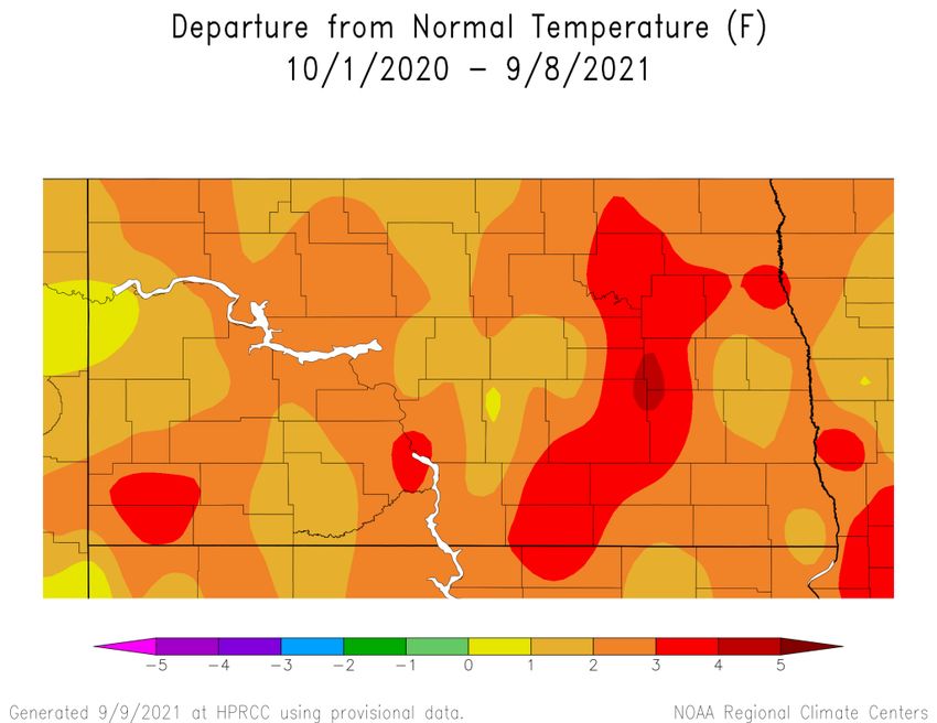
Drought Briefing 9/9/2021
3:30 PM
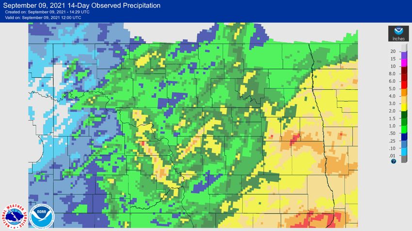
Current Conditions
Most of the state received beneficial rains over the past 14 days, except for parts of
the west. Drought conditions improved in a few areas, with soil moisture
percentiles very low across the west but near normal in the far southeast.
Drought Briefing                                                    9/9/2021
                                                                                     3:30 PM
               Future Potential Impacts
Climate
September has been slightly warmer than normal so far, with above normal temperatures
favored through the end of the month. Precipitation has been near normal, with below
average precipitation favored through the end of September. Beneficial rains from the past
few weeks led to improvement of drought conditions across parts of the state. The trend
towards above average temperatures weakens for the fall season, with below average
precipitation still favored during this time. Confidence continues to increase that La Niña will
develop during the late fall and early winter. This would favor colder than average
temperatures during the winter and early spring, but does not provide any tilting of the odds
towards above, below, or near normal for winter precipitation.
Hydrology
Despite the brief respite recent rains have provided, overall the region is still within a longer
term drought. Nonetheless, recent rains and cooler weather have combined to provide some
relief and that has been reflected with some improvement on the USDM map. This
improvement is generally limited to a greening of the countryside as lakes, rivers, and
wetlands have not yet rebounded to near normal levels, nor has there been significant
production of forage for livestock. Some of this is season dependent as native grasses
generally go dormant by the end of September due to the average first frost across the state
being roughly the third week of September. Once vegetation dies or becomes dormant
comes the best opportunity to start improving soil moisture for the next growing season.
Lower temperatures and lack of vegetative transpiration allows any moisture received a
better opportunity to infiltrate soils and be stored for our next growing season.
Fire Weather
Recent widespread rain has resulted in new grass growth over much of the area. The
exception is some parts of western North Dakota where the rains missed. With that said,
taller and denser cured grass can still readily carry fire. In addition, dead wood fuels remain
very dry and readily burn, especially over many parts of western North Dakota. Therefore,
fire concerns continue.
Drought Briefing                                        9/9/2021
                                                                  3:30 PM
        USGS Streamflow Levels

Streamflow levels are near normal in most locations. Only a few isolated
      locations show much below or much above normal levels.
Drought Briefing 9/9/2021
3:30 PM
CPC 8-14 Day Outlook for September 17-23Drought Briefing 9/9/2021
3:30 PM
CPC Seasonal Outlook for September-October-NovemberDrought Briefing 9/9/2021
3:30 PM
CPC Seasonal Outlook for November-December-JanuaryDrought Briefing 9/9/2021
3:30 PM
Summary
• Drought is expected to persist through the fall, with some improvement of
drought conditions recently due to widespread rain.
• Warm and dry weather is favored for the rest of September, with a weak tilt
towards a warm and dry fall across the state.
• Although recent rains are resulting in new grass growth, taller and denser
cured grass can still readily carry fire. Also, dead wood fuels continue to
readily burn, especially over many parts of western North Dakota. Therefore,
fire concerns continue.
Partners
National Drought Mitigation Center - https://drought.unl.edu/
National Integrated Drought Information System - https://www.drought.gov/drought/
USDA Climate Hubs - https://www.climatehubs.usda.gov/hubs/northern-plains
US Forest Service - https://www.wfas.net/
US Geological Survey - https://waterwatch.usgs.gov/
Midwestern Regional Climate Center - https://mrcc.illinois.edu/
High Plains Regional Climate Center - https://hprcc.unl.edu/
ND Response Burn Bans and Fire Danger Maps - https://www.ndresponse.gov/burn-ban-
restrictions-fire-danger-maps
Report Drought Conditions: https://droughtreporter.unl.edu/submitreport/
View Drought Reports: https://droughtreporter.unl.edu/map/
Please monitor our web page for updates: www.weather.gov/bis &
www.weather.gov/fgf
Follow us on Facebook and Twitter for the latest information:
@nwsbismarck NWSBismarck
@nwsgrandforks NWSGrandForksYou can also read