Hydrocarbon accumulation in basins with multiple phases of extension and inversion: examples from the Western Desert (Egypt) and the western Black ...
←
→
Page content transcription
If your browser does not render page correctly, please read the page content below
Solid Earth, 12, 59–77, 2021
https://doi.org/10.5194/se-12-59-2021
© Author(s) 2021. This work is distributed under
the Creative Commons Attribution 4.0 License.

Hydrocarbon accumulation in basins with multiple phases of
extension and inversion: examples from the Western Desert
(Egypt) and the western Black Sea
William Bosworth1 and Gábor Tari2
1 Apache Egypt Companies, 11 Street 281, New Maadi, Cairo, Egypt
2 OMV   Upstream, Exploration, Trabrennstrasse 6-8, 1020 Vienna, Austria

Correspondence: William Bosworth (bill.bosworth@apacheegypt.com)

Received: 5 June 2020 – Discussion started: 30 June 2020
Revised: 2 November 2020 – Accepted: 4 November 2020 – Published: 14 January 2021

Abstract. Folds associated with inverted extensional faults         1   Introduction
are important exploration targets in many basins across our
planet. A common cause for failure to trap hydrocarbons in          Although the concept of structural inversion has now ex-
inversion structures is crestal breaching or erosion of top seal.   isted for over a century (Lamplugh, 1919), it was Glennie
The likelihood of failure increases as the intensity of inver-      and Boegner (1981) who explicitly used this term to describe
sion grows. Inversion also decreases the amount of overbur-         the formation of a specific structure in the southern North
den, which can adversely affect maturation of source rocks          Sea. Shortly thereafter Bally (1984) generalized the concept.
within the underlying syn-extensional stratigraphic section.        The importance of inversion tectonics to both academic re-
However, many rift basins are multi-phase in origin, and            searchers and industry experts was quickly recognized as
in some cases the various syn-rift and post-rift events are         shown by several subsequent seminal works (e.g. Cooper and
separated by multiple phases of shortening. When an in-             Williams, 1989; Buchanan and Buchanan, 1995). Kley and
version event is followed by a later phase of extension and         Krzywiec (2020) provide a discussion of the past 30-year his-
subsidence, new top seals can be deposited and hydrocar-            tory of positive inversion as a structural geology concept.
bon maturation enhanced or reinitiated. These more com-                Positive structural inversion entails partial or even com-
plex rift histories can result in intra-basinal folds that have     plete reversal of extensional (“normal”) offset on a fault and
higher chances of success than single-phase inversion-related       the formation of associated anticlines. These features are of
targets. In other basins, repeated inversion events can oc-         considerable interest to oil and gas explorationists. The op-
cur without significant intervening extension. This can also        posite process of negative inversion, in which contractional
produce more complicated hydrocarbon maturation histories           (“reverse”) offset is removed, is generally of less economic
and trap geometries. Multiple phases of rifting and inver-          significance. “Positive inversion”, or just simply “inversion”
sion affected numerous basins in North Africa and the Black         for the remainder of our discussion, has many effects on all
Sea region and produced some structures that are now pro-           aspects of petroleum systems: maturation, migration, trap-
lific hydrocarbon producing fields and others that failed. Un-      ping, and sealing. A certain combination of these effects
derstanding a basin’s sequence of extensional and contrac-          could either improve or degrade the pre-drill risk profile
tional events and the resulting complex interactions is essen-      of a hydrocarbon exploration target (e.g. Macgregor, 1995;
tial to formulating successful exploration strategies in these      Turner and Williams, 2004; Cooper and Warren, 2010; Be-
settings.                                                           van and Moustafa, 2012; Tari et al., 2020). Failure to recog-
                                                                    nize the impact of inversion on a basin’s geologic evolution
                                                                    can have a disastrous impact on an exploration program.
                                                                       Inversion tectonics become increasingly complex when-
                                                                    ever there are multiple phases of extension or shortening, as

Published by Copernicus Publications on behalf of the European Geosciences Union.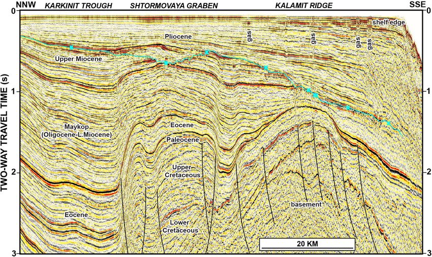
60 W. Bosworth and G. Tari: Hydrocarbon accumulation in inverted basins
2 Western Desert
The Egyptian Western Desert includes all the land west of
the Nile Delta, Nile River, and Lake Nasser to the border
with Libya (Fig. 2). The first economic oil or gas discovery
in the Western Desert was Alamein field, found by Phillips
Petroleum Company in 1966 (Metwalli and El-Hady, 1975;
Egyptian General Petroleum Corporation, 1992; ∼ 210 mil-
lion barrels oil (mmbo) in-place resource). The principal
reservoir interval is Aptian age dolostone, located in an
ENE–WSW-trending elongate faulted anticline. Although
not discussed in early interpretations of the field, Alamein
is an inverted structure, with shortening imposed in the Late
Cretaceous. Other inversion-related traps were subsequently
found, including the first oil and gas discovery in the massive
Abu Gharadig basin in 1969 (Abu Gharadig field; El Gazzar
et al., 2016; ∼ 415 million barrels oil equivalent (mmboe)
in-place resource). Years later, when the inverted Qarun field
was found in 1994, it marked the largest Egyptian discovery
in about a decade (Abd El-Aziz et al., 1998; ∼ 200 mmboe
in-place resource). Unfortunately, many unsuccessful wells
were also drilled on the subsurface crests of other large West-
ern Desert inversion folds. Failure was often attributed to the
erosion of top seal and breaching of the underlying reservoir
objectives.
Alamein, Abu Gharadig, Qarun, and most other Western
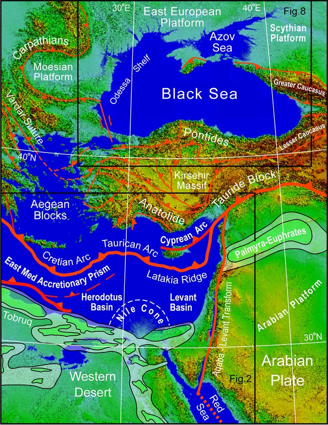
Figure 1. Tectonic setting of the Western Desert (Egypt), eastern
Desert inverted structures were formed by extension and as-
Mediterranean and Black Sea. Plate boundaries and major faults are
shown in red. Triangles are on upthrown blocks of thrust and reverse
sociated subsidence in the Late Jurassic to Early Cretaceous,
faults. Major sedimentary basins of the Western Desert and Arabian followed by shortening in the Late Cretaceous to Eocene.
plate are shaded in green. Locations of Fig. 2 (eastern part) and The Late Cretaceous inversion, or “Santonian event”, was by
Fig. 8 are shown by boxes. Modified from Okay and Tüysüz (1999) far the most significant compressional tectonics to affect the
and Bosworth et al. (2008) and references therein. Base is SRTM Western Desert during the Phanerozoic, but there were other
digital elevation model (Jarvis et al., 2008). UTM Zone 36 projec- compressional events. We first briefly outline the tectonos-
tion. tratigraphic history of the Western Desert and then describe
less frequently observed inversion in the Early Cretaceous;
this is followed by an example of the main Santonian inver-
compared to the one-time extension–shortening cycle. The
sion.
general aim of this paper is to provide examples of this com-
plexity by highlighting exploration programs that targeted
2.1 Geologic setting
structures that experienced very different multi-phase inver-
sion histories. We focus on the greater eastern Mediterranean
The Phanerozoic history of the Western Desert was shaped
region, where basins present both commonalities and differ-
by the opening of first Paleotethys and then Neotethys, which
ences in their Neotethyan to present-day tectonostratigraphic
morphed into the modern Mediterranean Sea when the sea-
histories (Fig. 1). The Western Desert of northern Egypt is
way between Arabia and Eurasia closed about 15 Ma. Ex-
selected to show a case in which multiple phases of shorten-
tensional structures related to Paleotethys are present in the
ing were separated by multiple syn- and post-rift extensional
subsurface of the Western Desert but are presently not well
events. In contrast, the NW Black Sea has a rift basin fab-
known. Neotethyan rifting, however, left a complex legacy of
ric that was formed by multiple phases of extension during
multi-phase basins along the northern margin of Gondwana
the Triassic to Cretaceous but then was inverted by multi-
(Fig. 2). Further west in Algeria and Tunisia initial opening
ple phases of shortening during the Cenozoic without any in-
began in the Permian and by the Triassic had reached north-
tervening extensional periods. Besides illustrating the multi-
ern Egypt and the Levant and a seaway extended into Syria
faceted impact on the petroleum system elements, these case
(Şengör, 1979; Stampfli et al., 2001; Garfunkel, 2004; Berra
studies could also potentially serve as exploration templates
and Angiolini, 2014). Permian and Triassic continental strata
in basins with similarly complex tectonostratigraphic evolu-
are encountered in wells in the far Western Desert and in out-
tion.
crops along the Gulf of Suez. Like the Paleozoic section, rel-
Solid Earth, 12, 59–77, 2021 https://doi.org/10.5194/se-12-59-2021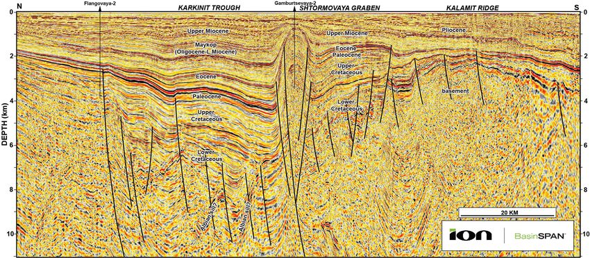
W. Bosworth and G. Tari: Hydrocarbon accumulation in inverted basins                                                                  61

Figure 2. Egypt’s Western Desert and its regional geologic setting. Location is shown in Fig. 1. Box shows the location of Fig. 4 and the
position of Fig. 7 is indicated. Increasingly milder inversion is observed moving south into the Gulf of Suez region. Similar trends are
probably present in the Western Desert, but exposures of suitably aged rocks are generally lacking. A: Alamein basin; AG: Abu Gharadig
basin; M: Matruh basin; S: Shushan basin. Triassic opening direction and Neotethyan oceanic–continental crustal boundary after Longacre
et al. (2007). Plate boundaries (bold lines), basins, and regions of inversion from Bosworth et al. (2008) and references therein.

atively little is known regarding the structural setting of these      ger with siliciclastic rocks that are ascribed to the Khatatba
units.                                                                 Formation (Norton, 1967; Fig. 3). The Khatatba Formation is
   The earliest well-defined rifting event in the Western              both an important reservoir objective and the most important
Desert occurred during the Middle to Late Jurassic and estab-          source rock in the Western Desert (Keeley et al., 1990).
lished the general basin configuration that persisted through             Western Desert “Jurassic” rifting was relatively short-lived
most of the Mesozoic (Keeley and Wallis, 1991; Guiraud,                and ended in the earliest Cretaceous, spanning a period of
1998). Most faults active in the Jurassic are oriented E–W to          ∼ 10 Myr or less (∼ 150–14 Ma). The syn-rift stratigraphy
ENE–WSW with an ∼ N–S extension direction (Fig. 3). This               varies dramatically in thickness and facies from sub-basin to
structuration is generally attributed to the distal effects of the     sub-basin. In general, the section is much thinner in the west
continued opening of Neotethys further to the north. How-              and south and thickens toward the north. At the end of the
ever, potential fields and seismic datasets acquired over the          Jurassic to earliest Cretaceous, a widespread but brief ma-
past several decades suggest that the eastern Mediterranean            rine incursion resulted in the deposition of Masajid Forma-
basin segment opened with a WNW–ESE extension direc-                   tion open marine limestone facies over most of the Western
tion and that the Egyptian margin was a transform boundary             Desert, except on a few, high-standing platform areas (Fig. 3;
(Longacre et al., 2007). Resolving the apparent disconnect             Norton, 1967; Keeley et al., 1990).
between the Egyptian offshore and Western Desert onshore                  Immediately following Masajid flooding, during which ac-
basin kinematics will be important to establishing a better un-        tive extensional faulting is not recognizable in most sub-
derstanding of the geodynamic evolution of NE Gondwana.                basins, a second phase of rifting initiated with strata assigned
   In the western Faghur and Shushan sub-basins, Jurassic              to the Alam el Bueib Member of the Burg el Arab Formation
rifting was marked by an early phase of volcanism, mostly              (Fig. 3; Norton, 1967). This is the most pronounced exten-
in the form of local basaltic flows, tuffs, and volcaniclastics        sional phase in most Western Desert sub-basins and lasted
(Abbas et al., 2019). The volcanics are overlain and interfin-         about 14 Myr (∼ 139–125 Ma). Extension was also initially

https://doi.org/10.5194/se-12-59-2021                                                                   Solid Earth, 12, 59–77, 2021
62                                                    W. Bosworth and G. Tari: Hydrocarbon accumulation in inverted basins

Figure 3. Mesozoic to Cenozoic tectonostratigraphy of the Western Desert and Black Sea regions. Extensional and shortening events are
separated for clarity. In some basins both extensional and contractional inversion structures are observed to have developed simultaneously.
Timescale is from Ogg et al. (2016). Gr: group; Fm: formation; Mb: member; St: suite.

N–S directed, but midway through the rift event, extension              hariya times. In other parts of Gondwana, the Albian–Aptian
rotated to NE–SW (Fig. 3).                                              was the most important phase of extension, as was the case
   In addition to the strong clockwise rotation of the exten-           in much of the central African rift system (Schull, 1988;
sional stress field, which is also recognized in many other             McHargue et al., 1992; Bosworth, 1992).
basins of north and central Gondwana (Guiraud and Bellion,                 Sea-level rise in the Cenomanian and Turonian resulted
1995; Guiraud, 1998; Guiraud and Bosworth, 1999; Guiraud                in flooding of all the Western Desert and establishment of
et al., 2001, 2005), the Western Desert experienced a pulse             an epeiric sea that would last into the early Cenozoic (Said,
of compression at about 138 Ma, which we refer to as the                1962; Kerdany and Cherif, 1990). These marine strata are
late Cimmerian event (Fig. 3). This shortening only affected            assigned to the upper Bahariya and Abu Roash formations
a small number of faults, an example of which is discussed              (Fig. 3; Norton, 1967) and were deposited during a rela-
below.                                                                  tively quiescent period in the Western Desert. In the Sirt
   The Alam el Bueib phase of rifting, like the Khatatba,               basin to the west (Fig. 2), this was a time of significant ex-
ended with a second even more regionally extensive ma-                  tension and subsidence in its NW–SE-trending sub-basins
rine flooding event, which deposited the Alamein and Da-                (Wennekers et al., 1996; Abadi et al., 2008). The Western
hab members (Norton, 1967). NE–SW-oriented extension re-                Desert calm was abruptly terminated at 84 Ma with the onset
newed in the mid-Aptian at about 120 Ma, and marine de-                 of the main pulse of regional basin inversion, the Santonian
position was replaced by predominantly fluvial deposits of              event (Moustafa and Khalil, 1995; Guiraud and Bosworth,
the Kharita Member and Bahariya Formation (Said, 1962;                  1997; Guiraud, 1998; Bevan and Moustafa, 2012). Santonian
Norton, 1967). Kharita–Bahariya rifting was prolonged, last-            compression, shortening, and inversion were of true plate-
ing about 20 Myr (∼ 120–100 Ma), but generally occurred at              scale significance, as was recognized long ago by Burke and
slower extension rates that gradually dissipated in lower Ba-           Dewey (1974).

Solid Earth, 12, 59–77, 2021                                                                    https://doi.org/10.5194/se-12-59-2021
W. Bosworth and G. Tari: Hydrocarbon accumulation in inverted basins 63
Santonian inversion can be interpreted to be a consequence
of a change in relative movement between the Eurasian
and African plates, with N–S divergence switching to N–S
slightly oblique convergence (Savostin et al., 1986; Le Pi-
chon et al., 1988; Dewey et al., 1989). Convergence contin-
ues to the present day and was manifest in North Africa by a
series of compressional pulses, interspersed with periods of
quiescence or extension that were spatially complex (Bevan
and Moustafa, 2012). The most pronounced post-Santonian
shortening occurred at the end-Cretaceous and within the
late Eocene, corresponding to coeval compressional maxima
in the Alpine belt of Eurasia (Fig. 3; Guiraud et al., 1987;
Guiraud and Bosworth, 1997; Guiraud, 1998).
During and following Santonian inversion, shallow ma-
rine carbonate environments continued across the Western
Desert with deposition of the Khoman Formation (Fig. 3;
Norton, 1967). The Khoman, which is commonly a chalky Figure 4. Inverted structure trend of the Phiops field shown on a
time structure map of the eastern North Faghur basin. Mapped hori-
facies, is completely missing from the crests of some ma-
zon is top Khatatba Formation. Location of the map is shown in
jor Santonian inversion structures. Apollonia Formation (a
Fig. 2. Position of Fig. 5 is indicated. The reverse fault that inverts
term borrowed from Libyan stratigraphy) limestone depo- the structure becomes a blind fault along-strike but can be observed
sition commenced following the base Cenozoic unconfor- at deeper horizons.
mity and generally continued until the late Eocene deforma-
tion when the northern Western Desert epeiric seas began
to retreat and siliciclastic deposition returned (Dabaa Fm.;
Norton, 1967). Mixed carbonate and siliciclastic deposition The only places where an early phase of shortening and in-
continued through the Oligocene and Miocene (Moghra and version have been observed are on a few of the ENE–WSW-
Marmarica Fms.; Said, 1962), punctuated by a very brief striking faults, as along the Tayim-/Phiops trend (Fig. 4).
period of basaltic volcanism at 24–22 Ma that was related There the inversion affected a small segment of the fault sys-
to Red Sea rift initiation (Fig. 3; Meneisy, 1990; Bosworth tem that dipped NW, just north of the large Kalabsha horst
et al., 2015a). Most of the Western Desert, excluding some block. Early syn-rift growth on this fault was small but re-
coastal regions, experienced gradual uplift and erosion from solvable (Fig. 5). Inversion occurred during deposition of the
the late Miocene to the present day. basal units of the Alam el Bueib Member, so in very early
Cretaceous times. Based on this timing and in accordance
2.2 Faghur basin Cimmerian inversion with the better documented tectonic phases of SE Europe we
designate the inversion a “late Cimmerian” event (Nikishin
Faghur is the westernmost sub-basin of the northern Egyp- et al., 2001; Stampfli et al., 2001). Minor folding and local
tian Western Desert rift system (Fig. 2). Exploration started erosion of this age have been observed elsewhere in North
there in the late 1950s encouraged by success to the west in Africa, the Benue trough, the Levant margin, and the Ara-
the basins of Libya. However, the first commercial discovery bian platform (summarized in Guiraud et al., 2005).
was not made until 2006. The only documented functioning Alam el Bueib syn-rift phase 2 strata drape over and
source rock in the Faghur basin is the Khatatba Formation seal the inversion anticline (Fig. 5). Differential compaction
(Bosworth et al., 2015b; Fig. 3), which was deposited during across the structure affected most of the mid- and upper Alam
the short-lived Late Jurassic first phase of rifting. The Alam el Bueib strata resulting in four-way dipping (domal) un-
el Bueib-6 unit at the base of the second more profound Early faulted closures higher in the section. In detail, the hinge
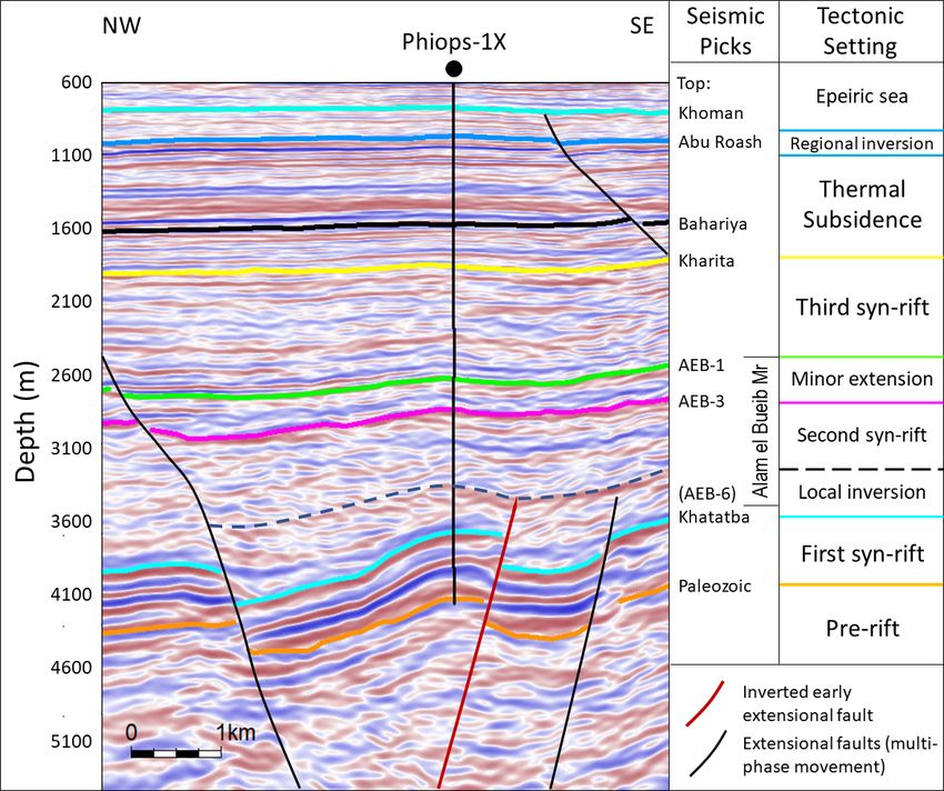
Cretaceous rifting event may also have local source potential of the Phiops fold is doubly plunging and not exactly par-
at Faghur. allel to the underlying contractional fault (Fig. 6). The hinge
Extensional faults that affect the Khatatba and immedi- curves away from the ENE–WSW-striking fault becoming
ately overlying Masajid Formation strike predominantly in NE–SW trending. This suggests that the shortening direc-
two orientations: E–W or ENE–WSW (Fig. 4). Like the other tion was approximately NW–SE oriented. Along strike sev-
main sub-basins of the Western Desert, most of these faults eral other smaller inversion anticlines are recognized, and to
dip to the south, which is significant as the coeval Neotethyan the north the fold trend steps to the east across another major
margin stepped down to the north. The south dip probably down-to-the south early extensional fault.
reflects reactivation of a pre-existing basement or Paleozoic In the Faghur basin oil migration commenced in the Late
(Hercynian?) structural fabric. Cretaceous (Bosworth et al., 2015b; Abdelbaset et al., 2019),
long after the late Cimmerian inversion structure was formed.
https://doi.org/10.5194/se-12-59-2021 Solid Earth, 12, 59–77, 2021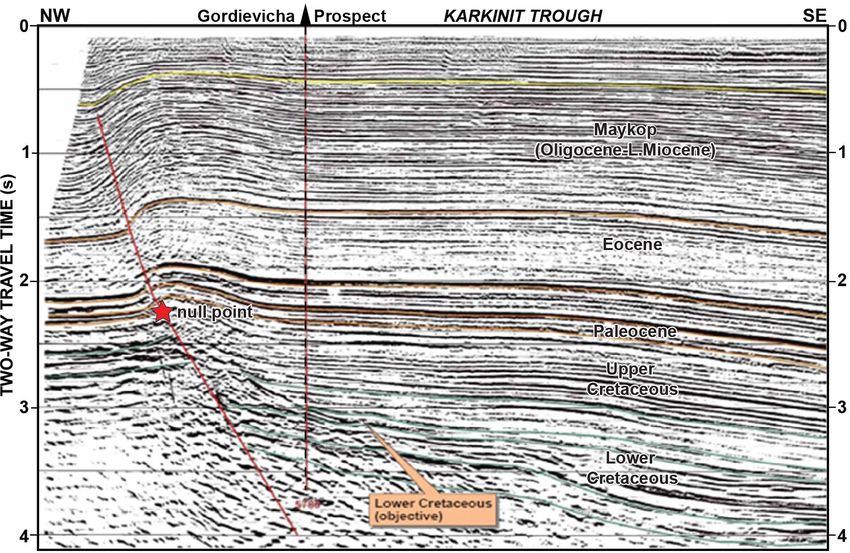
64                                                       W. Bosworth and G. Tari: Hydrocarbon accumulation in inverted basins

Figure 5. Depth-migrated seismic line through the inversion struc-
ture at Phiops field. Inversion occurred during the deposition of the     Figure 6. Detailed top Khatatba Fm time structure map of the
lower part of the Alam el Bueib Member. This was followed by              Phiops inversion trend. Other wells have been removed for clarity.
differential compaction over the structure but no further shorten-        See Fig. 4 for location and legend. Position of Fig. 5 is indicated.
ing. The later Santonian “regional inversion” did not significantly
impact this part of the Western Desert, but its effects are locally ob-
servable. Location is shown in Fig. 4. For ages of seismic markers,
see Fig. 3. ∼ 1.7 vertical exaggeration.                                  Yousef et al., 2010, 2019; Bevan and Moustafa, 2012). In
                                                                          the eastern sub-basins of the Western Desert, inversion is
                                                                          manifest at both the scale of individual faults and across
Reserves are trapped in both pre- and post-inversion silici-              complete sub-basin profiles. Shortening was intense in the
clastic reservoirs. The amount of shortening at Phiops is not             Alamein, Abu Gharadig, and Matruh sub-basins (Fig. 2) but
large, although it did remove all the early extension on the              as discussed above largely absent from the westernmost re-
fault and all units now display reverse offset. The Phiops in-            gions. Near the border with Libya, almost all the Late Creta-
version is restricted to a single fault trend and had no no-              ceous shortening occurred further to the north in Cyrenaica,
ticeable effect at the scale of the Faghur sub-basin. No re-              which acted as a promontory or indenter during the Eurasia–
serves have so far been recovered from the overthrust foot-               Gondwana collision (Bosworth et al., 2008).
wall block.                                                                  A regional transect of the Alamein and East Abu Gharadig
   The products of younger inversion are present in the                   basins illustrates the scale and significance of Late Creta-
Faghur basin but are very minor. Structures formed by Santo-              ceous and younger inversion in the eastern Western Desert
nian shortening include small folds of the Abu Roash strata               (Fig. 7; see also Bevan and Moustafa, 2012, their Fig. 19.7).
(Fig. 3) along the large basin-bounding faults. This was of               The stratigraphy of the eastern sub-basins is very similar to
no consequence to the hydrocarbon system of the sub-basin.                that of Faghur in its overall framework. In detail, several dif-
Slightly more significant was renewed NE–SW-directed ex-                  ferences can be noted: (1) the pre-Jurassic stratigraphic sec-
tension and accompanying sedimentation during the Campa-                  tion is much thinner or absent completely; (2) particularly in
nian and Maastrichtian, which provided additional overbur-                the north, depositional facies in the Jurassic and Cretaceous
den and therefore helped to accelerate maturation of the deep             tend to display more marine affinities; (3) thickness varia-
Khatatba source rocks. Late Cretaceous NW–SE shortening                   tions in the Cenozoic section are much more dramatic, in part
and NE–SW extension were probably at least in part coeval                 due to the effects of late inversion; and (4) a gentle, regional
at Faghur.                                                                northward tilt of the late Miocene to Holocene section, par-
                                                                          ticularly in the Alamein basin (not observed in Faghur).
2.3   Alamein-East Abu Gharadig basins Santonian                             The most pronounced shortening at the longitude of Fig. 7
      inversion                                                           occurred at the Mubarak inversion where crystalline base-
                                                                          ment now structurally overlies part of the early syn-rift
Late Cretaceous shortening in the Western Desert has been                 stratigraphy. The inverted fault at this position was not
extensively documented, both in outcrop (Moustafa, 1988;                  the original basin-bounding fault but rather cuts through
Abdel Khalek et al., 1989; Moustafa et al., 2003) and the                 the axis of the early basin. The area is covered by good-
subsurface (Kerdany and Cherif, 1990; Moustafa et al., 1998;              quality 3D seismic reflection data, and along-strike the basin-

Solid Earth, 12, 59–77, 2021                                                                     https://doi.org/10.5194/se-12-59-2021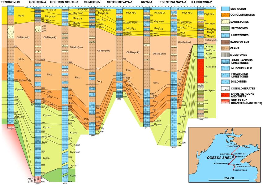
W. Bosworth and G. Tari: Hydrocarbon accumulation in inverted basins                                                                65

Figure 7. Regional geoseismic section across the eastern part of the Western Desert. Location is shown in Fig. 2. The massive Mubarak
inversion is one of the best examples of Western Desert Santonian inversion followed by younger pulses of shortening. After Bosworth et
al. (2008). Four times vertical exaggeration.

bounding and inverted faults merge to produce a more “typ-            hydrocarbons suggesting that oil migration and trapping oc-
ical” inverted extensional fault. Other less prominent inver-         curred and then was lost. The Phiops, Misaada, and Gondul
sion structures, more akin to the scale of Early Cretaceous           trends are much smaller structures than Mubarak, and all dis-
Cimmerian shortening described at Faghur, are present at              play very complex local fault patterns. Offset locations and
Misaada and Gondul (Fig. 7).                                          similar play types to these wells were not always successful
   The most prominent inversion-related unconformity                  either.
across all these eastern basin structures initiated in the San-          In addition to breaching structurally shallow reservoirs,
tonian. Pronounced onlap of the Campanian–Maastrichtian               the large Western Desert inversions such as Mubarak also
Khoman chalk onto the Mubarak fold is evident in seismic              interrupt hydrocarbon maturation processes, at least over
lines (Bevan and Moustafa, 2012). A second, dramatic un-              the region undergoing significant uplift. Estimating how
conformity at Mubarak developed at the end of the Mesozoic,           much stratigraphic section was removed, rather than non-
indicating renewed shortening and denudation that continued           deposited, is a complex and difficult problem to address
into the late Eocene.                                                 as relevant data (e.g., thermochronometric) are often lack-
   The total Jurassic to present-day stratigraphic thickness of       ing. The potential effects of inversion-driven denudation on
the Alamein, East Abu Gharadig, and Faghur basins are quite           paleo-heat flow are another consideration, generally not well-
comparable, generally 5–6 km in the vicinity of the main              constrained or even considered.
basin axes. However, the geothermal gradients at Alamein                 Basin-scale inversions like Mubarak also drastically im-
and East Abu Gharadig are higher than at Faghur, and there-           pacted migration pathways (Bevan and Moustafa, 2012).
fore oil generation commenced earlier, generally in the mid-          Prior to Santonian inversion, almost all hydrocarbons being
Cretaceous. Migration was well underway by the time of                generated and expelled from the Jurassic Khatatba Forma-
the Santonian inversion and more so for the later pulses of           tion in the East Abu Gharadig basin were flowing through
compression. Breaching of some reservoirs that had already            carrier beds up-dip to the south, toward Misaada and Gondul
trapped hydrocarbons was inevitable. Fortunately for the in-          (Fig. 7). During Santonian and younger inversion, the basin
version structures in Fig. 7, numerous reservoir horizons re-         axis progressively migrated to the south, with more and more
mained intact and Early Cretaceous syn-rift exploration tar-          of the deeper stratigraphic section rotating and ultimately
gets were successful.                                                 dipping to the south, refocusing migration to the north. Un-
                                                                      derstanding these changes in migration paths, which can oc-
2.4   Significance of multiple inversion events to Western            cur at both local and regional scales, is important to success-
      Desert hydrocarbon systems                                      ful exploration strategies.

The exploratory wells drilled on the inversion structures of          3   Black Sea
Figs. 5 and 7 were all successful. Along strike, other wells
were not so lucky. Other parts of the Mubarak inversion were          The Black Sea is classically divided into two separate basins
uplifted and eroded more deeply than at the EB-32A location.          – the western and eastern Black Sea basins (WBSB and
In some cases, wells encountered reservoirs with residual             EBSB) – with the divide formed by the Andrusov and

https://doi.org/10.5194/se-12-59-2021                                                                  Solid Earth, 12, 59–77, 2021
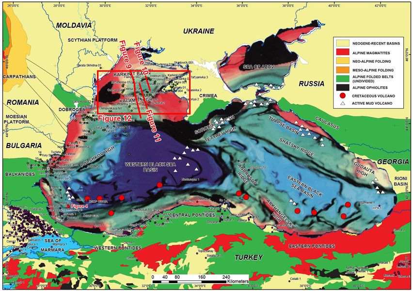
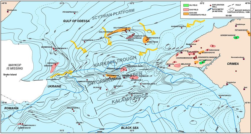
66                                                   W. Bosworth and G. Tari: Hydrocarbon accumulation in inverted basins

Figure 8. Simplified structural map of the Black Sea modified from Tari and Simmons (2018). Location is shown in Fig. 1. Within the Black
Sea itself, the depth-to-break-up unconformity is shown, cold colors indicating greater depth, adapted from Robinson (1997). Black lines
between the Carpathians and the Black Sea correspond to major faults pre-dating the opening of the Black Sea (Krezsek et al., 2017). White
triangles represent offshore mud volcanoes and red dots represent Cretaceous paleo-volcanoes (Nikishin et al., 2015a). The locations of a
depth-converted, regional seismic line (Fig. 10), two vintage seismic profiles (Figs. 11 and 12), and a Maykop (Oligocene to lower Miocene)
isopach map (Fig. 13) are shown by red lines.

Arkhangelsky ridges and the Tetyaev high (collectively, the             an inverted anticline (Robinson et al., 1996; Alaygut et al.,
mid-Black Sea high), which trend approximately north–                   2004; Menlikli et al., 2009) due to the regional shortening as-
south in the central part of the Black Sea (Fig. 8). Our study          sociated with late Eocene basin-scale inversion. In the Gulf
area is in the broader Gulf of Odessa (or Odessa Shelf) lo-             of Odessa of Ukraine the first offshore discovery was Golit-
cated in the northern part of the WBSB. Our database is com-            syna in 1975 (Fig. 8), an anticline with Paleocene chalk and
posed of about 8000 km of legacy 2D reflection seismic data             Oligocene sandstone reservoirs displaying renewed episodes
and close to 90 wells drilled for hydrocarbon exploration pur-          of inversion after the largest late Eocene one (Robinson and
poses.                                                                  Kerusov, 1997; Khriachtchevskaia et al., 2009, 2010).
   There are several examples of inversion structures with as-             After briefly describing the tectonostratigraphic evolu-
sociated hydrocarbon fields in the Black Sea. In the Histria            tion of the WBSB, we provide a modern, depth-converted,
trough of Romania (Fig. 8), multiple phases of Cenozoic in-             regional-scale seismic illustration of the multiple inversion
version have been described (Morosanu, 2002; Dinu et al.,               periods in the Karkinit basin, Shtoromoe graben, and Kalamit
2005). Drilling in the Romanian Black Sea started in 1976               high area (Fig. 8). An additional legacy 2D seismic example
and led to the discovery of the Lebada field in 1981, which             was selected to show the untested deep gas potential along
has a trap with an element of inversion (Krezsek et al., 2017).         the northern perimeter of the inverted Karkinit basin. Finally,
In the Turkish sector, the biogenic gas field of Akcakoca was           we highlight the un(der)explored intra-Maykop stratigraphic
discovered by Turkish Petroleum in 1976 (Fig. 8). Subse-                play potential. This is directly linked to the strongest late
quent drilling proved the commerciality of this gas find reser-         Eocene inversion episode in the Black Sea area, which cre-
voired in middle Eocene turbidites. The trap for this field is          ated pronounced lateral variations in accommodation space.

Solid Earth, 12, 59–77, 2021                                                                   https://doi.org/10.5194/se-12-59-2021
W. Bosworth and G. Tari: Hydrocarbon accumulation in inverted basins                                                                         67

Figure 9. Regional correlation of wells drilled on the Odessa Shelf, compiled from various sources (e.g. Gozhik et al., 2006, 2010). For
location, see map inset. Depth of stratigraphic tops are in meters. Note that none of the deep basins (e.g. Karkinit basin) have been penetrated
to their full depth, unlike the basement highs (e.g. Kalamit high).

3.1   Geologic setting                                                    back (Stephenson and Schellart, 2010). However, a debate in
                                                                          the literature is still ongoing regarding not only the geody-
                                                                          namic reason for the basin opening but also its timing and
The Black Sea is a Cretaceous basin complex superposed                    kinematics (Tari, 2015; Tari et al., 2015).
on the northern margin of the Tethys/southern margin of                      The Black Sea basin opened in a complex manner and
Laurussia (Nikishin et al., 2001; Okay and Nikishin, 2015).               Tari (2015) distinguished two major rifting periods within
The Mesozoic pre-rift tectonostratigraphy of the WBSB is                  the Cretaceous. Initial rifting started as soon as the Bar-
quite complex as it has elements of Early to Middle Trias-                remian and became regionally widespread in a “wide-rift”
sic rifting, Late Triassic–Early Cimmerian orogenesis, Juras-             mode by the Aptian–Albian (syn-rift stage 1; Fig. 3) with nu-
sic back-arc extension, and the Late Jurassic–late Cimmerian              merous rift sub-basins trending NW–SE or E–W (Robinson
regional compressional phase (Fig. 3; Nikishin et al., 2001).             and Kerusov, 1997; Krezsek et al., 2017). There is surface
These alternating extensional and compressional cycles pro-               and subsurface evidence for Albian volcanics in the area,
duced inverted structures, like those of the Triassic rifts on            including western Crimea (Nikishin et al., 2013), and the
the Scythian Platform and in Dobrogea (Saintot et al., 2006),             mostly andesitic volcanism appears to be limited to the E–
but these are typically poorly understood subsurface features.            W-trending Karkinit basin. The trend of rifting changed to
   The Black Sea basin complex is traditionally thought to                NE–SW at the end of the Albian and a new rifting period oc-
be a marginal or back-arc basin with active rifting beginning             curred during the Cenomanian to Santonian (syn-rift stage 2;
in the mid-Cretaceous (Finetti et al., 1988; Nikishin et al.,             Fig. 3). During this time a “narrow-rift” style of much larger-
2015a, b). In terms of geodynamic models of modern back-                  scale regional volcanic back-arc extension was superimposed
arc basin formation, this extension was driven by slab roll-

https://doi.org/10.5194/se-12-59-2021                                                                        Solid Earth, 12, 59–77, 2021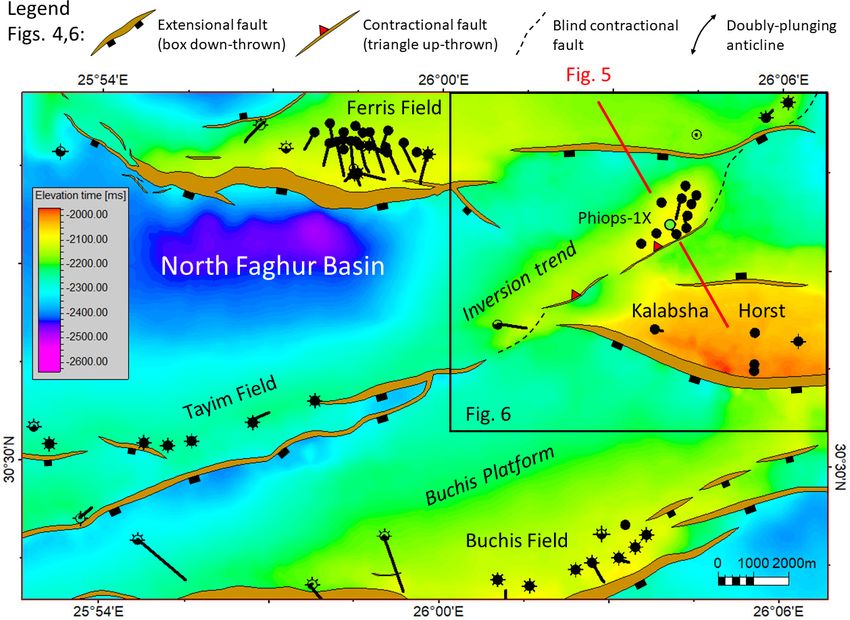
68                                                    W. Bosworth and G. Tari: Hydrocarbon accumulation in inverted basins

Figure 10. Regional-scale pre-stack depth migrated (PSDM) seismic reflection profile across the Odessa Shelf, courtesy of ION. For location,
see Fig. 8. Note the >7500 m deep Karkinit trough in the middle of the section and the Kalamit ridge to the south of it. Approximately five
times vertical exaggeration.

on the Early Cretaceous, mostly a non-volcanic extensional                 Regionally, the Oligocene to lower Miocene Maykop For-
system. By the Santonian, the WBSB opened to its full ex-               mation (Vernyhorova and Ryabokon, 2020; Figs. 3, 9) post-
tent and in our study area the top Santonian is considered              dates the two Eocene discrete inversion events as can be
by Khriachtchevskaia et al. (2010) as the ultimate break-up             deduced from the onlap geometries seen on reflection seis-
unconformity.                                                           mic data (Fig. 10). The early and middle Miocene saw an-
   Since the first basin-wide distributed volcanics are Tur-            other two inversion events (circa 16.3 and 10.4 Ma) in our
onian in age, the WBSB evolved as a sensu stricto back-                 study area (Khriachtchevskaia et al., 2010). The pronounced
arc basin only during the Turonian–Santonian interval (Tari,            diapir-looking structure (Gamburtsev) in the middle of the
2015). The subsequent widespread Campanian volcanism                    regional seismic line (Fig. 10) is an extreme example of the
in the Pontides, and its assumed equivalent in the Turkish              multiple contractional reactivation of an already existing in-
offshore area (Nikishin et al., 2015a), was interpreted by              verted structure. The inversion process was quite selective
Tari (2015) as being arc-related but post-dating the opening            spatially and temporarily across the Odessa Shelf, as not all
of the WBSB.                                                            the pre-existing Cretaceous master faults were reactivated in
   The uppermost Cretaceous and lower Paleogene (Pale-                  any given cross section (Fig. 10). However, the large border
ocene to middle Eocene) stratigraphy of the Odessa Shelf                fault on the northern margin of the Karkinit basin did expe-
is dominated by chalks (Figs. 3, 9), reflecting tectonic qui-           rience reactivation along strike to the east in the area of the
escence in a post-rift setting. The first compressional event           Golytsina gas-condensate field (Fig. 11). The seismic expres-
disrupting the waning subsidence pattern happened at the end            sion of both the footwall and hanging wall is clear and even
of the middle Eocene at about 38.6 Ma (Khriachtchevskaia et             the position of the null point can be determined with confi-
al., 2010), and the deposition of carbonates was replaced by            dence. The inversion clearly post-dated the Maykop Forma-
shales (Figs. 3, 9). During the late Eocene at about 35.4 Ma,           tion and therefore is post-early Miocene in age.
another basin-wide shortening episode produced the bulk of                 The Sudak folded belt offshore Crimea (Tari and Sim-
the inverted structures (Khriachtchevskaia et al., 2010). This          mons, 2018) formed during the Miocene (Stovba et al., 2009,
“Pyrenean” event (Fig. 2) is considered as the most signif-             2013, 2017; Sheremet et al., 2016a, b) in multiple stages
icant one in the broader Black Sea area, and it can be cor-             (Fig. 3). The corresponding Miocene compressional episodes
related with the last phase of overthrusting in the Balkans             with slightly rotating but generally N–S-oriented compres-
(Doglioni et al., 1996; Bergerat et al., 2010). The Crimean             sional stress fields were documented by micro-tectonic stud-
Mountains also experienced shortening-related uplift during             ies in onshore Crimea (Murovskaya et al., 2014; Hippolyte
this time based on apatite fission-track studies (Panek et al.,         et al., 2018). The challenge onshore, just like in the offshore,
2009).                                                                  is that these stages or events cannot be precisely dated, i.e.

Solid Earth, 12, 59–77, 2021                                                                    https://doi.org/10.5194/se-12-59-2021
W. Bosworth and G. Tari: Hydrocarbon accumulation in inverted basins                                                                     69

Figure 11. Legacy 2D seismic reflection profile across the undrilled Gordievicha prospect, adapted from Burchell (2008). For location, see
Fig. 8. The position of the null point, sensu Williams et al. (1989), is shown by a red star.

Figure 12. Seismic reflection evidence for post-Sarmatian inversion. For location, see Fig. 8. The southward prograding Pliocene sequence
above the Sarmatian (late Miocene) unconformity (shown in blue) is clearly back-rotated. This is due to the multiple episodes of inversion
forming the overall structure containing the relatively small Shtormovaya field on its northern flank (e.g. Khriachtchevskaia et al., 2009).
Note the gradual incorporation of the earlier Eocene folds into a much larger Miocene to Pliocene inversion anticline. Vertical exaggeration
is ∼ 6× assuming an average seismic velocity of 4 km s−1 .

with a resolution of less than 1–2 Myr, and separated thus              suspended. This is contrary to the models of Robinson et
far. This limitation is primarily due to the lack of Miocene            al. (1995) and Nikishin et al. (2003), who suggested an accel-
sediments in the Crimean Mountains onshore and the lack                 erated period of subsidence in the Black Sea basin complex
of sufficiently dense sampling of the stratigraphy in offshore          since the late Miocene or Pliocene, respectively, as the re-
industry wells.                                                         sult of an overall N–S-directed compressional stress regime
   Khriachtchevskaia et al. (2010) argued that the period of            down-bending the basin center. Whereas this subsidence is
discrete inversion ended by the late Miocene or at least was            difficult to document given the resolution of the biostrati-

https://doi.org/10.5194/se-12-59-2021                                                                     Solid Earth, 12, 59–77, 2021
70                                                 W. Bosworth and G. Tari: Hydrocarbon accumulation in inverted basins

graphic dating, a closer look at the available seismic reflec-     and 440 km2 , respectively (Sergey Stovba, personal commu-
tion data does provide definitive evidence for ongoing post-       nication, 2010) with multi-trillion cubic feet recoverable gas
late Miocene compression in the Gulf of Odessa.                    potential. However, these structures are clearly not filled to
   We chose a legacy 2D seismic line across the Shtor-             spill and the observed gas columns are in the range of tens of
movoe inversion anticline to show how this particular feature      meters. The underfilled trap issue can be explained by charge
displays signs of repeated and also neotectonic shortening         limitations, trap timing versus charge and/or by trap failure or
(Fig. 12). This broad, 20 km wide structure is a composite         breaching. Given the multiple (up to four) inversional events
one at depth; below about 1 s two-way travel time, it splits       shaping these anticlines individually, losses to several rem-
into two inversion anticlines, 4 and 12 km across. These cor-      igration periods between the inversions probably played a
respond to earlier Eocene inversion events. With the contin-       role. These risks also explain why some of the large inverted
uous thickening of the sedimentary cover, the earlier Eocene       structures in the area turned out to be dry, like the prominent
inversion anticlines were incorporated into a broader, single      Gamburtsev anticline (Fig. 10).
Miocene to Pliocene anticline.                                        There are two schools of thought as to finding more hydro-
   A key observation regards the geometry of a prograding          carbons in this seemingly mature petroleum province. One
shelf margin sequence over the apex of the structure which         suggestion was made by Burchell (2008), who described a
postdates the pronounced regional intra-Sarmatian (Kherso-         new gas play type associated with the deeper part of the
nian) unconformity dated as circa 7.5 Ma in the Black Sea          Golitsyno anticline, beneath the producing lower Paleocene
(Fig. 12; Popov et al., 2010). The clinoforms in this prograd-     chalks (Fig. 11; Robinson and Kerusov, 1997). Four possi-
ing unit are slightly back-rotated to the north and their top      ble gas-charged Lower Cretaceous sand targets were con-
laps, which should be sub-horizontal, show ∼ 2–4◦ north-           sidered within the rift basin fill of the Karkinit trough at
ward tilt (Fig. 12). There are also two onlapping reflectors on    4500 to 5500 m depth (Fig. 11). These targets with struc-
the northern flank above the prograding sequence. Given the        tural dip in three directions that closes against a fault have
dimensions of the structure and the timing, this back-rotation     a large map-view extent, on the order of about 300 km2 .
cannot be attributed to differential compaction. These obser-      Hydrocarbon charge was deemed to be relatively low risk
vations underscore the reactivation of the inversion process       by Burchell (2008) given the gas-condensate finds in adja-
during the Pliocene.                                               cent fields and assuming thick gas-mature Lower Cretaceous
   The present-day stress field in the area, based on earth-       shales in between the sand units in the so far undrilled rift
quake focal mechanism studies, is a compressional-to-strike-       basin center. Upper Cretaceous calcareous black shales, as
slip one (Murovskaya et al., 2018) which is consistent with        potential source rocks, have been documented on the west-
other regional observations of ongoing N–S-directed com-           ern part of the Crimean Peninsula (Kitchka et al., 2016). The
pression in the broader Black Sea area (Tsereteli et al., 2016).   obvious exploration risks of this deep, inversion-related play
                                                                   include side seal against crystalline basement across the large
3.2   Implications for NW Black Sea exploration                    inverted fault, the presence and quality of the Lower Creta-
                                                                   ceous reservoir objectives and trap definition due to the lack
There are several hydrocarbon fields in the Gulf of Odessa         of 3D seismic data. This deep play remains untested to date.
and the adjacent Crimean Peninsula (Fig. 13). The Odessa              The other line of thought is represented by Nedosekova
Shelf was explored for the last 5 decades, and eight               et al. (2008) emphasizing the underexplored nature of strati-
gas and gas-condensate fields have been discovered, all            graphic and combination traps in the region, such as sand
drilled in jack-up water depth (less than 100 m). Explo-           body pinchouts along the flank of paleo-highs. To show the
ration was historically focused on the inverted structural         impact of the Eocene inversion events shaping the paleo-
highs. The productive horizons are related to Upper Creta-         relief of the basin, we reproduce here the isopach map of
ceous (Maastrichtian), Paleocene, Eocene, and Oligocene–           the Oligocene to lower Miocene Maykop sequence (Fig. 13;
lower Miocene reservoirs found at depths of 480–3000 m             Gozhik et al., 2010). Contrary to what basin-scale well cor-
(Khriachtchevskaia et al., 2009; Stovba et al., 2009). The         relations can indicate, incorporating data points from basin
two largest gas and condensate finds – Golitsyno and Shtor-        highs (Fig. 9) the Maykop isopachs shows dramatic vari-
movoe, with recoverable gas or condensate reserves of              ations between 0 and 1700 m across the Gulf of Odessa
420 bcf (bcf) (3 mmboe) and 777 bcf (21 mmboe), respec-            (Fig. 13). Given this range, we interpret a deepwater sedi-
tively – have been developed.                                      mentary environment for the Karkinit trough.
   Nedosekova et al. (2008) reviewed the drilled structures           Whereas the Maykop sequence overall is dominated by
and concluded that all the prospects and leads associated          shales (Fig. 9), as in the rest of the Black Sea (Tari and
with simple four-way closures have been tested. As a gen-          Simmons, 2018), there are reservoir quality deepwater sand-
eral observation, there seems to be a trap-fill issue as the in-   stones in it, as in the Krymska field (Fig. 13) and in the un-
verted structures could hold much larger hydrocarbon vol-          developed Subbotina oil discovery south of the Kerch Penin-
umes than the discovered resources. The map-view four-way          sula (Fig. 8), reported by Khriachtchevskaia et al. (2009)
closures of the Golitsyno and Shtormovoe anticlines are 680        and Stovba et al. (2009), respectively. Therefore, we spec-

Solid Earth, 12, 59–77, 2021                                                             https://doi.org/10.5194/se-12-59-2021
W. Bosworth and G. Tari: Hydrocarbon accumulation in inverted basins 71
Figure 13. Isopach map of the post-inversion Oligocene to lower Miocene Maykop Suite in the Odessa Shelf, modified from Gozhik (2010).
For location, see Fig. 8. Contour intervals are in meters. Note that the thickest Maykop is not captured by the currently available well control
(see Fig. 9). The depicted sediment entry points and the deep-water distribution patterns are entirely speculative and are shown here to
highlight the stratigraphic trapping potential in the Karkinit basin.
ulate that future regional-scale 3D seismic surveys could im- Gondwana and Pangea, the same intra-plate stress signal
age potential longitudinal and transversal intra-Maykop tur- could have been transmitted across entire continents and had
biditic systems within the Karkinit trough offering various a “global” impact. This would support the early perception
stratigraphic traps along the basin margin (Fig. 13). of Stille (1924), who assumed the existence of global oro-
genic phases. He based his observations mostly on data from
Europe and North Africa which could be the expression of
4 Discussion intra- or inter-plate stress peaks transmitted across this region
throughout most of the Phanerozoic. However, we emphasize
Interesting similarities exist between the tectonostratigraphic that Stille’s global phases are misleading in some cases. In
evolution of the Western Desert and the western Black Sea particular, the late Cimmerian event in Germany is a Late
(Fig. 3) even if these two areas are located some 2000 km Jurassic to Early Cretaceous rifting phase that created the
apart (Fig. 1). Whereas the relative chronology of alternat- Lower Saxony basin (Jonas Kley, personal communication,
ing extensional and compressional periods differs in many 2020). Since Stille believed that all unconformities are due
respects, several of the distinct inversion events appear to to folding or orogenesis (Kley, 2018), he mistakenly corre-
be the same. In particular, the earliest Cretaceous late Cim- lated the rifting event in Germany with contraction in North
merian and late Eocene “Pyrenean” phases correspond to Africa.
the same intra-plate shortening episodes. Inversion there- Regardless, more recently Guiraud (1998) and others
fore occurred synchronously over many adjacent lithospheric (Guiraud et al., 1987; 1992, 2001, 2005; Guiraud and Bel-
plates. This indicates that horizontal stress transmission oc- lion, 1995; Guiraud and Bosworth, 1997) have similarly
curred through well-coupled plate boundaries, in our case be- documented how precisely both Phanerozoic extension and
tween the African–Arabian, Anatolian, and Eurasian plates. shortening or inversion events can be correlated across Gond-
The question then becomes how far a certain peak in the wana and into nearby continental plates.
“inter-plate” horizontal stress can reactivate pre-existing ex- Another open-ended question relates to the duration of
tensional fabric and cause detectable structural inversion? these events. Are these phases, periods, or discrete events? If
Intuitively, when most or all the plates were in close con- the horizontal stress peaks are caused by sudden plate move-
tact with each other in large continental plate collages like ment changes, are they geologically instantaneous, i.e. on the
https://doi.org/10.5194/se-12-59-2021 Solid Earth, 12, 59–77, 202172 W. Bosworth and G. Tari: Hydrocarbon accumulation in inverted basins Figure 14. (a) Schematic illustration of some of the possible effects of superimposed, alternating phases of extension and inversion on a rift basin. For simplicity two inversion events are shown affecting different faults, which is commonly observed in the Western Desert of Egypt but will not always be the case. (b) Schematic illustration of a basin in which early extension is followed by multiple phases of inversion. The transect is largely based on observations made in the NW Black Sea, which experienced at least four distinct inversion episodes. order of 10–100 kyr, or more transient in nature, i.e. on the II versus Mode I, respectively, sensu Tari et al. (2020). Con- order of 100 kyr to 1 Myr? The duration and the rate of de- sequently, the latest Pliocene to neotectonic inversion in the formation during these inversion events have direct impact on NW Black Sea produced buckle folding of the thick, post- some of the petroleum system elements of any inverted struc- rift sedimentary cover instead of the “classic” reverse-fault ture. In the Faghur basin, the duration of the late Cimmerian bounded “Sunda-folds” (Eubank and Makki, 1981) that are inversion is less than the present resolution of both paleonto- more typically observed when the post-rift sequence is still logic and thermochronometric dating and probably less than relatively thin at the time of inversion. Earlier Black Sea in- 1 Myr. But the impact of the Santonian event varies widely version anticlines with a shorter wavelength were gradually from sub-basin to sub-basin across the Western Desert with incorporated into longer wavelength folds as the result of the no published quantitative estimates of its duration except that thickening sedimentary cover and the repeated inversional by 66 Ma a younger pulse of shortening can be distinguished. periods. The multiple Black Sea hydrocarbon remigration A more tightly constrained understanding of the temporal ex- episodes from older traps to relatively recently formed ones tent of such inversion events would be very beneficial in any appear to be the main reason for the underfilled or dry na- given basin analysis. ture of most structures in the NW Black Sea basin. Breached The Black Sea inversion structures do differ from those and leaky inversion traps are similarly a cause of failure in of the Western Desert in several important ways. In the the Western Desert, but the abundance of pre-inversion seal– Western Desert, the late Cimmerian and Santonian inver- reservoir pairs has resulted in a higher exploration success sions were separated by several phases of very significant rate. extension-driven subsidence. Inversion in the NW Black Sea was more rapid-fire, quickly superimposed compressional episodes. Also, the ratio of the post-rift (up to the strati- 5 Conclusions graphic level of the latest significant inversion event) versus syn-rift basin fill is much greater in the Black Sea than in the We have presented an example of a petroliferous basin in Western Desert reflecting the evolution of inversion in Mode which multiple tectonic shortening or inversion events were Solid Earth, 12, 59–77, 2021 https://doi.org/10.5194/se-12-59-2021
W. Bosworth and G. Tari: Hydrocarbon accumulation in inverted basins                                                                   73

separated in time and stratigraphic position by major exten-            remigration of hydrocarbons but can cause partial leak-
sional rift events – the Western Desert – and one where mul-            age or total breaching of some of the early traps.
tiple phases of inversion were superimposed on older, pre-
existing rift sequences – the NW Black Sea. Other tectonos-
tratigraphic sequences can be imagined, and no two real              3. Ongoing inversion can reconfigure the basin-scale
basins will be identical. Despite the great range of variations         geometry by creating new depocenters where syn-
that may exist, some general conclusions can be drawn and               inversion reservoirs can develop. The selective reacti-
depicted schematically (Fig. 14). For basins similar to the             vation of favorably oriented major faults may result in
Western Desert these include (Fig. 14a) the following:                  a polarity switch within sub-basins causing remigration
                                                                        and further loss of hydrocarbons. This explains the un-
 1. Shortening or inversion events that occur early in a                derfilled nature of most accumulations with otherwise
    basin’s extensional history are likely to produce viable            valid traps.
    traps for hydrocarbons in pre-, syn-, and immediate
    post-inversion (draping) strata because although some
    reservoirs may be breached, the structure will be cov-           4. Repeated episodes of mild to moderate inversion where
    ered and healed by later syn-rift fill. Furthermore, early          erosion does not remove strata over the growing struc-
    in the basin history hydrocarbons will not yet generally            tures can result in significant thickness of syn-inversion
    have started to migrate, so overall loses from the system           sediments. In this case, the contractionally reactivated
    are minimized.                                                      syn-rift normal faults cannot propagate through the en-
                                                                        tire post-rift basin fill and, therefore, the risk associ-
 2. Early inversion events can delay hydrocarbon matura-                ated with breaching becomes less critical. Some of the
    tion of underlying pre- or early syn-rift source rocks due          deeper inversion-related traps may even receive new hy-
    to denudation of strata, but only if the inversion is basin-        drocarbon charge from regional post-rift source rocks.
    scale. This is unlikely to be significant if shortening is          The presence of buckle folds at higher stratigraphic lev-
    mild and reverse movement is restricted to small-offset             els is typical for Mode II inversion structures where the
    faults.                                                             post-rift sequence is thicker than the syn-rift basin fill of
                                                                        the underlying extensional structure (Tari et al., 2020).
 3. Inversion, whether early or late, can dramatically im-
    pact migration pathways emanating from pre-inversion
    source rocks. This can occur at the scale of individ-
                                                                   Data availability. Some of the seismic lines used in this study are
    ual fault blocks or entire basins (see further discussion      confidential and not available publicly.
    in Bevan and Moustafa, 2012). Given that most exten-
    sional basins take the shape of large-scale half grabens,
    pre-inversion migration will generally be from basin           Author contributions. WB and GT wrote the text, prepared the fig-
    axes up-dip toward the flexural margin. Inversion can          ures, and compiled the paper.
    re-direct migration toward the faulted margin and fill
    previously unsourced structures.
                                                                   Competing interests. The authors declare that they have no conflict
 4. Late shortening or inversion events will generally have        of interest.
    more severe impact on top seal integrity because there
    is less chance for post-inversion deposition of new top
    seals.                                                         Special issue statement. This article is part of the special issue “In-
                                                                   version tectonics – 30 years later”. It is not associated with a con-
  For basins with histories more like the NW Black Sea             ference.
(Fig. 14b), the following apply:

 1. Early inversion events following a prolonged period
                                                                   Acknowledgements. We thank Jonas Kley and Piotr Krzywiec for
    of multiple rifting episodes are likely to produce traps
                                                                   inviting us to contribute this paper to the special issue of Solid
    which could by charged by initial hydrocarbon genera-          Earth and for their editorial efforts. Discussions concerning inver-
    tion from deeper syn-rift units. Most of the pre-existing      sion tectonics with Albert Bally, René Guiraud, Ahmed El-Hawat,
    normal faults tend to reactivate to accommodate inver-         Daniel Helgeson, Oxana Khriachtchevskaia, Alexander Kitchka,
    sion across the sub-basins.                                    Andrew Robinson, Daniel Stockli, and Sergiy Stovba are greatly ap-
                                                                   preciated. Dubravko Lučić, Csaba Krézsek, and Jonas Kley kindly
 2. Repeated episodes of inversion tend to be selective and        reviewed the paper for Solid Earth. The PSDM seismic section in
    only segments of the basin will experience reverse fault       the Gulf of Odessa is courtesy of ION and it is gratefully acknowl-
    movements along pre-existing fault planes. These can           edged. We thank Apache Egypt Companies and OMV for permis-
    enhance the already existing traps and cause additional        sion to publish this paper.

https://doi.org/10.5194/se-12-59-2021                                                                  Solid Earth, 12, 59–77, 2021
You can also read