JAPAN'S KUMANO KODO PILGRIMAGE - THE UNESCO WORLD HERITAGE TREK by Kat Davis - Cicerone
←
→
Page content transcription
If your browser does not render page correctly, please read the page content below
JAPAN’S KUMANO KODO
                              PILGRIMAGE
                         THE UNESCO WORLD HERITAGE TREK
                                      by Kat Davis

                              JUNIPER HOUSE, MURLEY MOSS,
                         OXENHOLME ROAD, KENDAL, CUMBRIA LA9 7RL
                                    www.cicerone.co.uk

972 Kumano Kodo.indd 3                                             16/01/2020 09:19
© Kat Davis 2019
First edition 2019
ISBN: 978 1 85284 972 6
Reprinted 2020 (with updates)
Printed in China on responsibly sourced paper on behalf of Latitude Press Ltd
All photographs are by the author unless otherwise stated.
A catalogue record for this book is available from the British Library.
Route mapping by Lovell Johns www.lovelljohns.com
Contains OpenStreetMap.org data © OpenStreetMap
contributors, CC-BY-SA. NASA relief data courtesy of ESRI
Updates to this Guide
While every effort is made by our authors to ensure the accuracy of guide-
books as they go to print, changes can occur during the lifetime of an edi-
tion. Any updates that we know of for this guide will be on the Cicerone
website (www.cicerone.co.uk/972/updates), so please check before plan-
ning your trip. We also advise that you check information about such
things as transport, accommodation and shops locally. Even rights of way
can be altered over time.
The route maps in this guide are derived from publicly available data,
databases and crowd-sourced data. As such they have not been through
the detailed checking procedures that would generally be applied to a pub-
lished map from an official mapping agency, although naturally we have
reviewed them closely in the light of local knowledge as part of the prepa-
ration of this guide.
We are always grateful for information about any discrepancies
between a guidebook and the facts on the ground, sent by email to
updates@cicerone.co.uk or by post to Cicerone, Juniper House, Murley
Moss, Oxenholme Road, Kendal, LA9 7RL.
Register your book: To sign up to receive free updates, special offers
and GPX files where available, register your book at www.cicerone.co.uk.
Front cover: Hatenashi settlement (Kohechi, Stage 4)
972 Kumano Kodo.indd 4 16/01/2020 09:19ROUTE 1
Hongu loop walk (including
Dainichi-goe and Akagi-goe)
Start/Finish Kumano Hongu Taisha 熊野本宮大社
Distance 16.7km
Ascent/Descent 875m
Difficulty Moderate
Duration 8hr–8hr 30min
Access Hongu: Hongu-taisha-mae bus stop 本宮大社前 バス
停 is the closest to Kumano Hongu Taisha, and Kumano
Hongu bus stop 熊野本宮 バス停 is the closest to the
Dainichi-goe trailhead in Hongu. Yunomine Onsen:
Yunomine Onsen bus stop 湯の峰温泉 バス停 is near the
Dainichi-goe and Akagi-goe trailheads. Hosshinmon-oji:
Hosshinmon-oji bus stop 発心門王子 バス停.
Waymarks The Dainichi-goe trail 大日越 from Hongu to Yunomine
Onsen has three waymarks counting up from 1 to 3.
The Akagi-goe trail 赤木越 from Yunomine Onsen to
Funatama-jinja Shrine has 11 waymarks counting down
from 11 to 1. The Nakahechi trail 中辺路 from Funatama-
jinja Shrine to Kumano Hongu Taisha has 17 waymarks
counting up from 59 to 75.
Note There are limited services so carry food and water and
set out early to complete the loop.
Detour between Funatama-jinja Shrine (waymark 59)
and Hosshinmon-oji (waymark 61). After crossing the
Otonashi-gawa River at the Akagi-goe trailhead, instead
of turning right towards Funatama-jinja Shrine, turn left
towards Nakahechi waymark 58. Between waymarks
57 and 56, turn right onto a forestry road and follow
this to Hosshinmon-oji. Due to this closure and being
unable to reach Inohana-oji, the stamp for Inohana-oji is
being held at the Hongu Heritage Center. Please check
for updates at www.tb-kumano.jp/en/kumano-kodo/
nakahech
97
972 Kumano Kodo.indd 97 16/01/2020 09:20Route 1 – Hongu loop walk (including Dainichi-goe and Akagi-goe)
steam and sulphur smells of Yunomine Onsen) and after
850m near Akagi-goe waymark 10, look right for moun-
tain views through the wire fence. A few minutes later
pass a small Akagi-goe stone marker (LHS, dated 1855,
with a finger pointing to Yunomine Onsen). Continue
ascending and after a further 700m pass Akagi-goe way-
mark 8. 4.6km
The trail soon starts to descend, then shortly after Nabeware Jizo means
passing Akagi-goe waymark 7, pass a small cemetery ‘broken pot Jizo’:
just before Kakihara-jaya teahouse remains 柿原茶屋跡 legend has it a young
(RHS). Turn left and pass a statue of the Buddhist monk disciple of Ippen
Kobo Daishi (LHS (774–835), the founder of Koyasan’s Shonin was making
Shingon Buddhist complex among many other things) rice here but ran out
and start uphill again for 1.1km to Nabeware Jizo 鍋割 of water and the pot
地蔵.46.3km cracked as a result.
Pass more mountain views then after a brief descent
climb to the highpoint of the stage (alt 450m) shortly
before Akagi-goe waymark 3. Continue as the trail undu-
lates, then a few minutes after passing Akagi-goe way-
mark 2, pass the stone foundations of the Kenjou tea-
house 献上茶屋跡 (no signpost) then turn right following
signs to Funatama-jinja and descend, steeply at times.
After 900m cross a log bridge over the Otonashi-gawa A section of the
River, then turn right. Pass a WC (LHS, women: 女子便所, Nakahechi trail
men: 男子便所) then a wooden pavilion housing an old between Funatama-
river boat (the nearby Funatama-jinja Shrine is associated jinja Shrine (waymark
with the legend of the first boat) before a red metal bridge 59) and Hosshinmon-
at the Akagi-goe trailhead 赤木越登り口. 8.5km oji (waymark 61)
Turn right onto a gravel road, following signs to is closed (as of
Hosshinmon-oji 発心門王子, now on the Nakahechi November 2019)
route, soon passing Nakahechi waymark 59 next to with a detour in
Funatama-jinja Shrine 船玉神社.4 place. See note.
Funatama-jinja Shrine is associated with the legend
of the god Susanoo who built the first wooden boat
nearby. Fishermen come here annually to celebrate
on 3 May. Tamahime Inari-jinja Shrine is on the
RHS, guarded by two foxes.
103
972 Kumano Kodo.indd 103 16/01/2020 09:20Route 2 – Nakahechi route, Stage 1
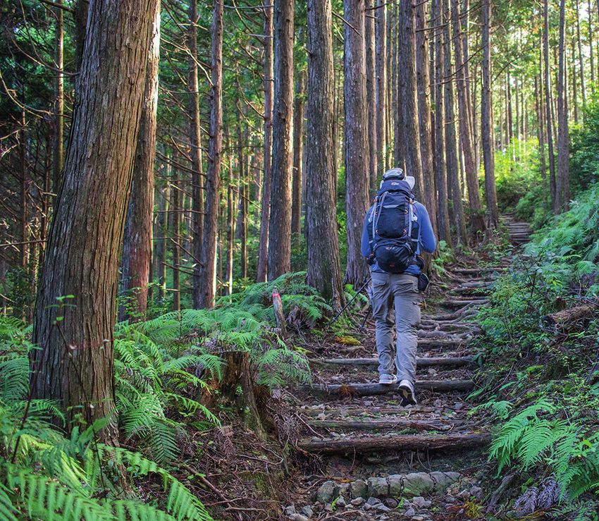
A hiker on the trail near Daimon-oji
Pass the oji and Nakahechi waymark 14 and climb
steeply for 300m then pass Koban Jizo 小判地蔵 –
established by locals in 1854 after a pilgrim was found
deceased here with a koban (old coin) in his mouth.
4The path undulates after Akushiro’s house site 悪四郎 There is a short
屋敷跡, then climbs steeply to reach the highpoint of the detour between
stage at Uwadawa Jaya teahouse remains 上多和茶屋跡 Koban Jizo and
(alt 680m). 9.1km waymark 15 due to a
Shortly after, pass Nakahechi waymark 18 and start landslide. Information
to descend, steeply at times for 800m before passing a can be found at
side-trail for the Three-Fold Moon viewpoint 三体月伝 www.tb-kumano.jp/
説 (associated with a local legend; however, there’s lit- en/kumano-kodo/
tle to see from the viewpoint other than the sky). Take nakahechi/
the lower left path here, descending towards Osakamoto-
oji 大坂本王子, then after passing Nakahechi waymark
20, turn right onto a wider track and go straight across a
119
972 Kumano Kodo.indd 119 16/01/2020 09:20Japan’s Kumano Kodo Pilgrimage
STAGE 2
Nonaka to Kumano Hongu Taisha
Start Tsugizakura-oji, Nonaka 継桜王子, 野中
Finish Kumano Hongu Taisha 熊野本宮大社
Distance 20.6km
Ascent 820m
Descent 1260m
Difficulty Moderate
Duration 8–9hr
Access The closest bus stop to Tsugizakura-oji is +0.9km
Nonaka Ipposugi 野中一方杉 バス停 (on Route 311, a
900m descent from Tsugizakura-oji). Bus stops between
Tsugizakura-oji and Hongu, bound for Hongu/Tanabe,
include: 2.6km +380m Kobiro-oji guchi 小広王子口 バ
ス停 (70m after passing Nakahechi waymark 39 turn
right onto a road, doubling back and downhill for 380m
to Route 311), 3.2km +400m Kobiro-toge 小広峠 バス
停 (200m after Nakahechi waymark 40, follow a Kobiro-
toge bus stop sign for 400m to route 311), 4.7km +600m
Doyugawa-bashi 道湯川橋 バス停 (400m after starting
the detour, instead of crossing the log bridge, continue
down the paved road for 600m to Route 311), 13.6km
Hosshinmon-oji 発心門王子 バス停, 20.6km Hongu-
taisha-mae 本宮大社前 バス停 (in front of Kumano
Hongu Taisha).
Waymarks Nakahechi 中辺路 wooden waymarks placed at 500m
intervals from 34 (soon after Tsugizakura-oji) to 75 (just
before Kumano Hongu Taisha).
Note This is a long stage with a hefty ascent and descent; if
you’d like to shorten the stage, consider taking a bus to
Kobiro-toge, Doyugawa-bashi or even Hosshinmon-oji.
There is a forestry road detour after waymark 56 to
Hosshinmon-oji (skipping waymarks 57 to 61) due to the
section of trail between Funatama-jinja Shrine (waymark
59) and Hosshinmon-oji (waymark 61) being closed (as of
November 2019). Due to this closure and being unable to
reach Inohana-oji, the stamp for Inohana-oji is being held
at the Hongu Heritage Center. Please check for updates at
www.tb-kumano.jp/en/kumano-kodo/nakahechi/
128
972 Kumano Kodo.indd 128 16/01/2020 09:20Route 2 – Nakahechi route, Stage 4
STAGE 4
Ogumotori-goe route: Koguchi to
Kumano Nachi Taisha
Start Koguchi village 小口
Finish Kumano Nachi Taisha 熊野那智大社
Distance 14.2km
Ascent 1180m
Descent 895m
Difficulty Hard
Duration 7–8hr
Access Koguchi is accessible by bus from Hongu or Shingu,
although you need to transfer at Kanmaru 神丸. There are
two bus stops in the area: Koguchi 小口 バス停 (closest
to the Ogumotori-goe trailhead) and Kowase 小和瀬 バス
停 next to the Kowase ferry remains and Kogumotori-goe
trailhead.
Waymarks Nakahechi Ogumotori-goe 中辺路 大雲取越 wooden
and stone waymarks placed at 500m intervals count
down from 29 (near the trailhead in Koguchi) to 1 (500m
before Kumano Nachi Taisha).
Note Carry food and water for the duration and allow plenty of
time for this challenging stage.
There is a well-marked detour between waymarks 20 and
16 along a forestry road that bypasses Ishikura-toge Pass.
The detour adds a further 40 minutes so allow sufficient
time for this section. Please check for updates at the
tourist offices in Tanabe or Hongu.
This stage is infamous for being the most challenging of the Nakahechi
as you gain 800m of elevation (Ogumotori 大雲取越 means ‘passing over
large clouds’) along a steep, rocky and often moss-covered slippery trail, in
addition to crossing three mountain passes. Consider this trail a lesson in
concentration (watching every step)! There are four rest shelters en route;
the shelter at Jizo-jaya teahouse remains makes a good lunch spot with a
vending machine and WC, and the shelter at Funamichaya teahouse has the
best views. The highpoint of the stage is the last mountain pass, Funami-toge
(alt 883m) and the descent from there to Nachisan is dominated by rocks
and flagstone paths (slippery when wet).
145
972 Kumano Kodo.indd 145 16/01/2020 09:20You can also read