NASA finds tropical cyclone Ann over the great barrier reef - Phys.org
←
→
Page content transcription
If your browser does not render page correctly, please read the page content below
NASA finds tropical cyclone Ann over the
great barrier reef
14 May 2019
satellite analyzed cloud top temperatures and found
cloud top temperatures of strongest thunderstorms
as cold as or colder than minus 63 degrees
Fahrenheit (minus 53 degrees Celsius) circling the
center and in a large band of thunderstorms north
of the center. Cloud top temperatures that cold
indicate strong storms that have the capability to
create heavy rain.
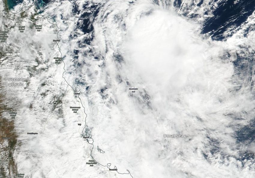
On May 14, NASA's Terra satellite provided a
visible image of the storm to forecasters. The
Moderate Resolution Imaging Spectroradiometer or
MODIS instrument aboard Terra captured the storm
as it was moving over the Great Barrier Reef in the
Coral Sea. Multispectral satellite imagery at the
time showed that an exposed, well-defined low-
On May 14, 2019 NASA's Terra satellite provided a level circulation center with a small area of
visible image of Tropical Cyclone Ann as it was moving
convection flaring 50 nautical miles to the south.
over the Great Barrier Reef in the Coral Sea. Credit:
NASA Worldview, Earth Observing System Data and
Information System (EOSDIS) Ann is weakening because it has run into increased
vertical wind shear, that is, winds blowing at
different directions at different levels of the
atmosphere tearing at the storm's structure. There
Australia's world-famous Great Barrier Reef is is also dry air moving into Tropical Cyclone Ann at
located in the Coral Sea, east of Queensland and low and mid-levels of the atmosphere, preventing
on May 14, Tropical Cyclone Ann was moving over the development of thunderstorms that fuel the
it. From their orbit in space, NASA's Terra and storm.
Aqua satellites passed over the Southern Pacific
Ocean obtained visible and infrared imagery of the The Australian Bureau of Meteorology or ABM
storm as it moved toward the Queensland coast. noted "Ex-tropical cyclone Ann expected to bring
damaging winds and heavy rainfall to parts of
The Great Barrier Reef is the world's largest coral northeast Queensland" and issued a Severe
reef system. The Reef is made up of more than Weather Warning for damaging winds and heavy
2,900 individual reefs and 900 islands that cover rainfall. The warning is for residents in parts of
more than stretching for over 1,429 miles (2,300 Peninsula, North Tropical Coast and Tablelands
kilometers). and Herbert and Lower Burdekin Forecast Districts.
An infrared look at the tropical storm obtained by
NASA's Aqua satellite revealed where the
strongest storms were located within Tropical
Cyclone Ann on May 13 at 0341 UTC (May 12 at
11:41 p.m. EDT). The Atmospheric Infrared
Sounder or AIRS instrument aboard NASA's Aqua
1/3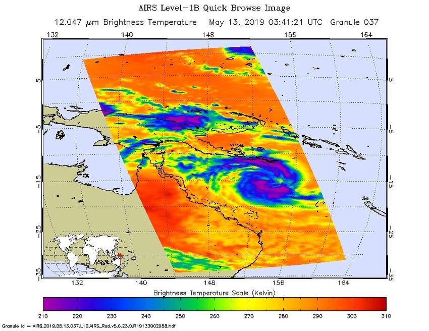
morning. This should gradually ease during
                                                        Thursday."

                                                        ABM Warnings are also available through TV and
                                                        Radio broadcasts, the Bureau's website at
                                                        http://www.bom.gov.au.

                                                        On May 14 at 5 a.m. EDT (0900 UTC), the center
                                                        of Tropical Cyclone Ann was located near latitude
                                                        14.3 degrees south and longitude 146.9 degrees
                                                        east. That is about 178 nautical miles northeast of
                                                        Cairns Australia. Ann was moving to the west and
                                                        had maximum sustained winds near 35 knots (40
                                                        mph / 65 kph).

                                                        The Joint Typhoon Warning Center expects Ann to
                                                        make landfall within 24 hours to the north of Cape
On May 13, at 0341 UTC (May 12, 2019 at 11:41 p.m.
EDT) the AIRS instrument aboard NASA's Aqua satellite
                                                        Melville National Park and Mungkan Kandju
analyzed cloud top temperatures of Tropical Cyclone Ann National Park, and dissipate less than a day later.
in infrared light. AIRS found coldest cloud top
temperatures (purple) of strongest thunderstorms were
as cold as or colder than minus 63 degrees Fahrenheit    Provided by NASA's Goddard Space Flight Center
(minus 53 degrees Celsius). Credit: NASA JPL/Heidar
Thrastarson

Additional warnings in effect on May 14 include a
Gale Warning for the Peninsula Coast and
Cooktown Coast, and a Strong Wind Warning for
the Cairns Coast, Townsville Coast and Mackay
Coast.

Local impacts include strong winds and heavy
rainfall. ABM cited "damaging winds, with peak
gusts of around 90 kph (56 mph) may develop
during Wednesday morning between about
Lockhart River and Cooktown, including Lizard
Island. The winds should gradually ease during
Wednesday afternoon as the low moves across
Cape York Peninsula.

Areas of heavy rainfall, which may lead to flash
flooding is expected to develop along the coast and
ranges between the Lockhart River and Port
Douglas Tuesday night, May 14 and persist through
Wednesday, May 15. A separate area of heavy
rainfall, which may lead to flash flooding, may also
develop about the coast and ranges between about
Gordonvale and Ingham during early Wednesday

                                                                                                     2/3
APA citation: NASA finds tropical cyclone Ann over the great barrier reef (2019, May 14) retrieved 29
                                   June 2022 from https://phys.org/news/2019-05-nasa-tropical-cyclone-ann-great.html

                                   This document is subject to copyright. Apart from any fair dealing for the purpose of private study or research, no
                                   part may be reproduced without the written permission. The content is provided for information purposes only.

                                                                                                                                                3/3

Powered by TCPDF (www.tcpdf.org)
You can also read