SEA LEVEL AND PALEOENVIRONMENT DURING ROMAN TIMES INFERRED FROM COASTAL ARCHAEOLOGICAL SITES IN TRIESTE (NORTHERN ITALY)
←
→
Page content transcription
If your browser does not render page correctly, please read the page content below
Available online http:/amq.aiqua.it
ISSN (print): 2279-7327, ISSN (online): 2279-7335

Alpine and Mediterranean Quaternary, 25 (1), 2012, 41-55

SEA LEVEL AND PALEOENVIRONMENT DURING ROMAN TIMES INFERRED FROM
     COASTAL ARCHAEOLOGICAL SITES IN TRIESTE (NORTHERN ITALY)

                                        Romana Melis1, Stefano Furlani2,1, Fabrizio Antonioli3,
                                         Sara Biolchi1,4, Valentina Degrassi5 & Karin Mezgec1
                                          1
                                        Dipartimento di Matematica e Geoscienze, Università di Trieste, Italy
                                              2
                                                Dipartimento di Geoscienze, Università di Padova, Italy
                                                                 3
                                                                   ENEA, ACS, Italy
                            4
                              Dipartimento di Scienze della Terra, Università degli Studi di Modena e Reggio Emilia, Italy
                                                            5
                                                              Archeotest Srl, Trieste, Italy
                                                 Corresponding author: S. Furlani

ABSTRACT: Paleoenvironment and sea level markers have been studied from new and published data at two archaeological sites in
Trieste. Results allowed to locate the Roman Age shoreline, presently buried under the city. Archaeological data clearly indicate the
presence of a well-organized Roman Age seaside, which gradually moved offshore.
       Imperial Roman Age structures have been found at the site located close to the Curia building. Archaeological finds indicate the
subsequent widening of the seafront. During the 1st century BC, a stone wall parallel to the coast already existed at the back of a sandy
beach. After the widening of the city, a large quay was built and the seafront moved offshore, covering the former Imperial Age struc-
tures. The quay was used up the 4th century AD.
       Late Roman Age structures have been found at the site called Cavazzeni. The period when the site was abandoned is clearly in-
dicated by the construction of the Medieval walls overtopping the Roman Age structures. The presence of two docks located just in front
of the site are reported in several sketches, maps and historical sources dated at the 16th-17th century. Microfaunistic composition of
sediments indicates that protected sectors of the harbour were built in order to allow the recovering of ships and other coastal activities.
       Archaeological finds together with paleoenvironmental data suggest that vertical tectonic movements in the urban area of Trieste
are significantly lower in respect of the Northern Adriatic. In fact, the presence of marine deposits with bad-preserved microfossils at ele-
vations higher than present-day mean sea level is related to the possible occurrence of a violent storm or a tsunami event. For the latter
case, radiocarbon date suggests a possible correlation to the 361 AD earthquake occurred along the Eastern Adriatic coasts.

Keywords: Urban archaeology, microfossils, sea level curves, Trieste, Italy.

1. INTRODUCTION                                                                hardt et al., 1994 and Sivan et al., 1999 in Israel; Pugliese
                                                                               et al., 1999 at the Aquileia harbour, for Italy; Goiran et al.,
       Archaeological sites along the Mediterranean coasts                     2005; Bernasconi et al., 2006; Bernasconi et al., 2007;
have undergone consistent environmental changes. In                            Stanley et al., 2008 (a, b) for the coastal settings of Egypt;
particular, the rapid sea level rise occurred during the                       Marriner & Morhange, 2007, for general Mediterranean
Early Holocene has required continuous adaptations of                          review; Amato et al., 2009 and Bernasconi et al., 2010; Di
human settlements to the alteration of the natural settings                    Bella et al., 2011; Mazzini et al., 2011 for Italian geoar-
(Pirazzoli, 1996; Di Bella et al., 2011). To this end, several                 chaeology; Ghilardi et al., 2011 for Greece). Paleoen-
multidisciplinary proxies from archaeological and geologi-                     vironmental data may integrate or improve data derived
cal disciplines are generally used to define these changes                     from geology and geomorphology and, in the end, they
(Lambeck et al., 2004a; Marriner & Morhange, 2007; An-                         provide useful information to evaluate local sea level
tonioli et al., 2009). Among them, the study of the coastal                    changes.
bioindicators (microfaunae) recorded in sediments and                                 Sea-level change is the sum of eustatic, glacio-
deposits of archaeological interest allow to reconstruct the                   hydro-isostatic and tectonic movements (Lambeck et al.,
ancient coastal paleoenvironments. The microfaunae of                          2004a). While the first is global and time-dependent, the
these environments consist of foraminifers, ostracods and                      latter two varies with location, sediment load, compac-
mollusks (bivalves and gastropods) well known in the                           tion and anthropogenic factors; the tectonic factors in-
Mediterranean coastal areas (Pérès & Picard, 1964; Bo-                         clude all movements that are not eustatic and isostatic
naduce et al., 1975; Pérès, 1982; Jorissen, 1988; Cimer-                       (Lambeck et al., 2004a), the glacio-hydro-isostatic com-
man & Langer, 1991; Sgarrella & Moncharmont Zei,                               ponent of post-glacial sea-level rise has been recently
1993; Montenegro et al., 1998). The coastal geoarchaeo-                        predicted and compared with field data at several
logy uses these faunae to identify the paleoenvironments                       coastal sites all over the Italian coasts (Lambeck et al.,
(rivers, swamps, marshes, lagoons, marine settings) close                      2004a; Antonioli et al., 2007, 2009; Faivre et al., 2011).
to human settlements, as already demonstrated in similar                       The results represent an useful framework for calculat-
Mediterranean coastal archaeological sites (e.g. Rein-                         ing vertical tectonic movements.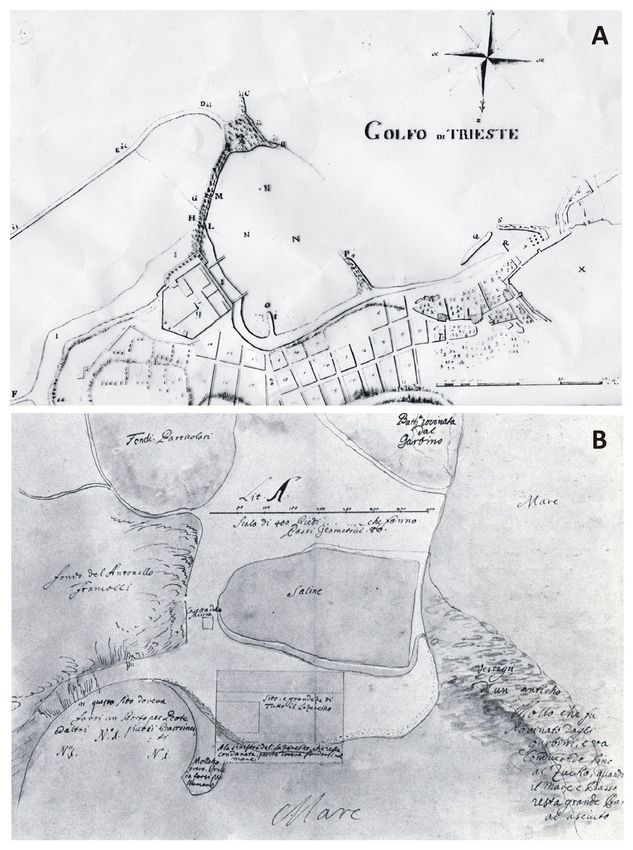
Melis R. et al.
42

                                                                                         2. THE STUDY AREA

                                                                                            2.1. Geological and geomorphological
                                                                                            background
                                                                                                    The city of Trieste (Fig. 1) is located
                                                                                            in the Eastern part of the homonymous
                                                                                            Gulf (NE Italy). The city lies on an Eocene
                                                                                            turbiditic succession (Flysch of Trieste),
                                                                                            Lutetian in Age (Bensi et al., 2007, Tirelli
                                                                                            et al., 2008).
                                                                                                    The area is part of the External Dina-
                                                                                            rides and is affected by a series of thrusts
                                                                                            which made the Cretaceous-Tertiary car-
                                                                                            bonate succession overlaying the Eocene
                                                                                            turbiditic one. The compressional tectonics
                                                                                            caused by the Dinaric orogeny (Late Juras-
                                                                                            sic-Early Oligocene) produced the deve-
                                                                                            lopment of NW-SE oriented and SW ver-
                                                                                            ging thrusts and the relative foredeep, with
                                                                                            flexuring of the Mesozoic carbonate and
                                                                                            filling by the Eocene Flysch. Late compres-
                                                                                            sional phases also involved the Flysch se-
                                                                                            quence in the thrusts (Doglioni & Bosellini,
                                                                                            1987; Castellarin et al., 1992).
                                                                                                    A thrust system crossing the Gulf of
                                                                                            Trieste with Dinaric orientation, has been
                                                                                            recently found from a multichannel seismic
Fig. 1 - Study area. Geological map of the urban area of Trieste (modified from Tirelli survey (Busetti et al., 2008, 2010). The sys-
et al., 2008) with the location of the archaeological sites. On the upper left-hand, a tem represents the most external Dinaric
tectonic sketch of the Gulf of Trieste showing major thrusts and faults in relation to thrusts. It is characterized by intense de-
the city of Trieste is reported (modified from Busetti et al., 2008; Carulli et al., 2011; formation, in particular within the Eocene
Furlani et al., 2011). Satellite images have been taken from Google Maps.                   Flysch sequences. It is affected by tectonic
                                                                                            activity lasting to the Plio-Quaternary. The
       The study of the sea-level changes during the Late                   structure deepens toward the northwest, probably due to
Holocene in the Northeastern Adriatic Sea has been                          the offset of NE-SW faults: the Monte Spaccato Fault
studied by a number of Authors (Degrassi, 1957; D’Am-                       parallel to the Northern Istrian coast (Cavallin et al., 1978;
brosi, 1958; Fouache et al., 2000; Antonioli et al., 2004,                  Carobene & Carulli, 1981), and a possible fault zone lo-
2007; Benac et al., 2004, 2008; Faivre et al., 2011;                        cated in the middle of the Gulf, separating the Northern
Degrassi et al., 2008; Furlani et al., 2011). Several geo-                  part from the Southern part (Busetti et al., 2008, 2010).
morphologic, biological and archaeological markers                          According to Carulli (2011), the Monte Spaccato and Sis-
have been used as source of information from which the                      tiana faults can be responsible for the formation of the
relative movements between land and sea can be eval-                        Gulf of Trieste.
uated. Regarding this area, previous studies evidenced                              Modelling of gravity data in the gulf of Trieste and
that Holocene submersion was largely completed about                        Karst area interpreted the minimum values occurring in
7 ka (cal) BP and that subsequently the sea level rose                      the Northern corner of the gulf as due to the deepening
slowly up to the current elevation (Antonioli et al., 2007,                 toward Northwest of the limestones and to the increase
2009). Moreover, marine notches or marine fossils have                      of Flysch thickness (Coren et al., 2006). Northwestward
never been found in this sector at elevation higher than                    tilting of the Karst area and its surroundings is confirmed
the present mean sea level, excluding a site with marine                    also by geodetic data (Braitenberg et al., 2005).
shells found by Antonioli & Furlani (2006) nearby Pola,                             From a geomorphological point of view, Trieste
at +0.70 m m.s.l. On the whole, recent archaeological,                      widens on a succession of ridges and valleys, the latter
geomorphological and geophysical data indicate for this                     filled by Quaternary alluvial and marine deposits.
area a vertical tectonic signal at a rate of about -0.75                    Coastal archaeological remains are usually built at the
mm/yr occurring during the last two millennia. It produc-                   Flysch cliff-foot. Alluvial deposits are mainly produced
es a significant downward displacement of the coastline                     by small temporary streams which flow to the sea,
of about 1.5 m / 1.8 m since Roman Age (Antonioli et                        sometimes close to the archaeological sites.
al., 2007, 2009). On the contrary, Degrassi et al. (2008)
and Furlani et al. (2011) suggested that, in the same                       2.2. Archaeological background
lapse of time, the urban area of Trieste should be rela-                            Regarding the presence of Roman Age remains in
tively stable in respect of the Northeastern Adriatic.                      Trieste, the archaeological findings discovered in the
       The micropaleontological and archaeological re-                      last decades during urban excavations deeply improved
sults presented in this work aim to refine previous inves-                  the knowledge of the Roman town (Maselli Scotti,
tigations in Trieste and both to add more information on                    2008). Since 16th century, local historians highlighted
the Roman Age sea-level and the anthropogenic varia-                        the presence of block alignments, wooden poles and
tion of the shoreline.                                                      harbour structures; coastal remains have been usually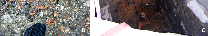
Sea level and paleoenvironment during Roman times inferred from coastal …                                                            43

reported at many sites in Trieste. Maselli
Scotti (2008) suggested that the landfills
between Roman Age coastal structures
were built at increasing steps, using
sandstone blocks for the construction of
retaining walls. Imperial Age structures
(late 1st century BC – early 1st century
AD) are usually covered by Late Roman
Age walls, the latter lying below recent
buildings.
      The maritime vocation of Trieste
during Roman Age is proven by the ex-
istence of two harbours (Maselli Scotti,
2008). Large remains of two docks (Fig.
2A), as part of the so called “porto es-
terno”, which correspond to the present-
day San Marco dock basin, were clearly
visible during the 18th century, as de-
scribed by Ireneo della Croce (1698).
They were composed by two large sea
walls: the Southwestern one was arch-
shaped; it connected the coast to a small
island, called "il Zucco", now completely
covered by the 17th century landfills,
while the northernmost is now included in
a present-day dock. The architectural
project for the construction of the lazaret -
project of the ÖKW, Wien, 1821- de-
scribes the presence of an ancient dam-
aged dock which were ruined by storms
(Fig. 2B). This structure emerged during
low tides. The seaside of the inner har-
bour was found in correspondence of
Cavana (Ventura et al., 2008) and
Cavazzeni street. Local archaeological
Superintendence found several sand-
stone blocks belonging to the Roman Age
docks.
                                                 Fig. 2 - Ancient maps of Trieste. A) Unknown Author, 1745. Map from the Project for
      The existence of a small harbour           the construction of the Borgo dei Santi Martiri and the new pier “Zucco”. Two piers are
was suggested from historical maps that          visible just in front of the Cavana area (Riavez, 1995); B) Unknown Author, 1821. Map
show two semi-submerged and ruined               from the Project for the construction of the lazaret, Wien ÖKW, with the description of
piers. They were included in the landfill for    an ancient pier “vestigii d’un anticho molo che fu rovinato dagli garbini, e va con-
the widening of the city and nowadays they       ducendo fino al Zucko, quando il mare e basso resta grande parte al asciuto”.
lay below modern buildings. Archaeologi-
cal remains are part of the Roman Age harbour, which                     foraminifers were determined in the 0.063 – 2.0 mm
presently lies below the 20th century buildings.                         sieving fraction. Species counts were performed and
                                                                         recorded as number of specimens of each taxon, re-
                                                                         ported as percentage in Tables 1 and 2. Selected
3. METHODS                                                               specimens were examined and photographed by a
      In 2008-2010, during the renovation works car-                     Leica Scanning Electron Microscope at the University
ried out in Trieste by the “Sovrintendenza per i Beni                    of Trieste (Plate I). Identification of foraminifer species
Archeologici del Friuli Venezia Giulia” (F. Maselli Scotti               follows the Mediterranean systematic suggested by Le
and P. Ventura excavation director), two archeological                   Calvez & Le Calvez (1958), Jorissen (1988), Cimer-
sites at “Cavazzeni” Street and in “Piazzetta S.ta Lu-                   man & Langer (1991), Levy et al. (1992), Hottinger et
cia”, close to the “Curia” Palace (Fig. 1), were discov-                 al., (1993) and Sgarrella & Moncharmont Zei (1993).
ered. Four bulk samples of sediments, corresponding                      For the consultation of the original taxa description, the
to different archaeological stratigraphic units (US)                     Ellis and Messina online catalogue on for aminifera
were collected at the “Cavazzeni” site, along a 1.50 m                   was used (http://www.micropress. org/).
thick vertical section. Additional 10 samples were col-                         Interpretation of the paleoenvironment was estab-
lected at the “Curia” site, along a 1.50 m thick vertical                lished by the comparison of the foraminiferal assem-
section (Fig. 3, 4).                                                     blages examined here and the ecological significance of
      The collected samples were washed using re-                        other associations from several Mediterranean coastal
spectively 2 mm and 0.063 mm sieves, both to sepa-                       areas: Tyrrhenian sea (Vismara Schilling & Ferretti,
rate the gravelly and the sandy fraction. Finally, the                   1987; Sgarrella & Moncharmont Zei, 1993; Bellotti et al.,
sediments were dried in an oven and weighted. The                        1994), Adriatic sea (Albani & Serandrei Barbero, 1990;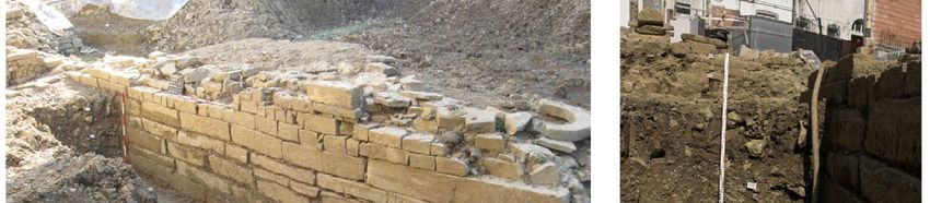
Melis R. et al.
44

Plate I - SEM photomicrographs of some foraminifer species representative of the studied sites (magnification: bar = 100 µm): 1 - Elphi-
dium aculeatum; 2 - E. pulvereum, side view; 3 - E. complanatum, side view; 4 - E. crispum, side view; 5 - Rosalina bradyi, spiral side; 6
- R. floridana, spiral side; 7 - Helenina anderseni, spiral side; 8 - Nubecularia lucifuga, spiral side; 9 - Ammonia beccarii, spiral side; 10 -
Discorbis aguayoi, umbilical side; 11 - D. aguayoi, spiral side; 12 - Adelosina carinato-striata, chamber view; 13 - Triloculina rotunda,
chamber side; 14 - Siphonaperta agglutinans, side view; 15 - Quinqueloculina nodulosa, side view; 16 - Quinqueloculina parvula, side
view.

Albani et al., 1991; Jorissen, 1988; Donnici & Serandrei                    Adam Mickiwicz University (Poland). They were cali-
Barbero, 2002) and the Late Quaternary of the Po Plain                      brated using the CALIB 5.0 program (Stuiver et al.,
near Ravenna (Fiorini & Vaiani, 2001).                                      2005).
     Radiocarbon dates have been provided by the                                 Ostracods were picked directly from sandy fraction
Poznan Rodiocarbon Laboratory, Foundation of the                            and then identified (Plate II). The number of specimens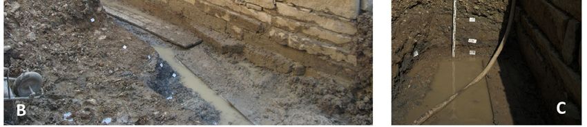
Sea level and paleoenvironment during Roman times inferred from coastal …                                                                45

Plate II - SEM photomicrographs of some ostracod species representative of the studied sites (magnification: bar = 100 µm): 1 - Pontocy-
there turbida, right valve; 2 - Xestoleberis communis, complete carapace in left lateral view; 3 - Aurila arborescens, right valve; 4 - Can-
dona neglecta (juvenile specimen), left valve; 5 - Leptocythere lagunae, complete carapace in left lateral view; 6 - Neocytherideis fascia-
ta, left valve; 7 - Hemicytherura videns (juvenile specimen), right valve; 8 - Schellencandona sp., complete carapace in left lateral view; 9
- Loxoconcha elliptica, complete carapace in left lateral view; 10 - L. stellifera, complete carapace in right lateral view.

for each sample was reported in Tables 1 and 2; the                         base sources of modern and Quaternary ostracods in
presence of juveniles was recorded to distinguish au-                       Mediterranean are provided by Bonaduce et al. (1975)
tochthonous from allochthonous specimens. The data-                         and Breman (1975) for the northern Adriatic Sea, Mon-
Melis R. et al.
46
On the contrary, when the elevations of
the markers are different from the predict-
ed values, downlift or uplift is suggested.
4. RESULTS
Archaeological and paleoenviron-
mental data collected in correspondence
of two archaeological excavations in Tri-
este, the “Curia” site (Fig. 3A-C) and the
“Cavazzeni” site (Fig. 4A-C), are hereinaf-
ter described.
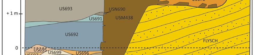
4.1. The “Curia” site
The investigations concern the dis-
covery of a luxurious 1st century AD sub-
urban villa overlooking a coastal road. The
excavation was carried out under the
pavement of the villa. It has revealed a
complex stratigraphy, which highlights an
impressive arrangement of the shore with
a NE-SW trending (USM438). The sea-
ward side was made up of squared blocks
which gradually diminish in size upward.
Excavations indicate the presence of a
quay constituted of a 2 m high sea wall
(Fig. 3A), dated back using ceramics be-
tween the 1st century BC and the 1st cen-
tury AD. It is grounded at -0.3 m a.s.l. on
the bedrock of the Roman Age shore plat-
Fig. 3 - The archaeological site at Curia. A) Representative sketch of the site; B)
form (Tab. 3). At its base, a sandy beach
and C) Views of the site.
(US698 - US699) occurs. It has been over-
laid by sandy levels rich in shell fragments
tenegro et al. (1998) for Italian seas and Athersuch interbedded with plant debris elements.
(1979) and Barbeito Gonzalez (1971) for Cyprus and The discovery of abundant ceramic in the strati-
Naxos Island, Greece. Other useful investigations in- graphic sequence permits to date this area at an age
clude the Nile delta margin core samples that provide ranging between the end of the 1st century BC and the
information on pre-modern Quaternary ostracods (Sneh early 1st century AD. Later, archaeological structures
et al., 1986; Pugliese & Stanley, 1991) and on Quater- were covered with filling materials (half of the 1st centu-
nary ostracods of Monastir, Tunisia (Wouters, 1973). ry AD). In this way, a new coastal road was built on the
Meisch (2000) has been used for fresh-water ostracods. widened shore.
The elevation of dated sea level markers (ar- In order to study the microfaunistic composition of
chaeological remains and sedimentological samples) this area, seven levels of the archaeological sequence
have been measured by GPS surveys. We estimated have been selected, from the bottom to the top as fol-
the elevations and ages of the archaeological bench- lows (Fig. 3A):
marks and evaluated their functional heights on the ba-
US699: -0.18 m m.s.l., seaward tilted/sloping;
sis of archaeological interpretations, following Lambeck
US698: -0.15 m m.s.l., tilted/sloping, centimeters sandy
et al. (2004b), Antonioli et al. (2007) and Auriemma &
level, located only at the base of the quay;
Solinas (2009) advices. Elevation errors are calculated
US697T: -0.15 m m.s.l., tilted/sloping; blue-gray (alluvi-
from measurements, while the uncertainty in archaeo-
al?) clay with abundant rounded sandstone clasts;
logical dating is estimated from the architectural fea-
US696: -0.12 m m.s.l., strongly tilted - sloping, levels
tures of the structures and pottery sherds or ceramics
rich in vegetate materials interbedded with sandy
found in the archaeological levels.
lenses. Thickness of this unit increases toward the
Past sea levels are evaluated considering the
seaside;
‘‘functional height’’ of archaeological structures. It is de-
US695: -0.10 m m.s.l., sandy levels with centimeter
fined as the elevation of specific architectural parts of
thickness, interbedded with thin organic (vegetate)
the structure with respect to the mean sea level at the
lenses;
time of their construction. It depends on the structure,
US692: +0.40 m m.s.l., plano-convex lens (max thick-
on its use and on the local tide amplitudes. The func-
ness 0.5 m) composed by rounded lithic fragments
tional height also defines the minimum elevation of the
of sandstone.
structure above mean sea level (Antonioli et al., 2007).
Data have been compared with predicted sea level The following units, US691, 690 and 693 are con-
curve (Lambeck et al., 2011) to define the tectonic be- sidered as anthropogenic backfilling.
haviour of an area. When data are in agreement with The foraminifers of this excavation consist of 24
the predicted sea level, tectonic stability is suggested. species pertaining to 12 genera (Tab. 1). Among them,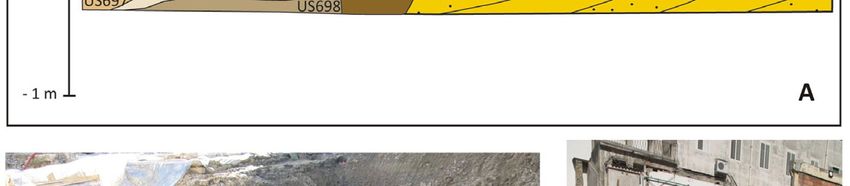
Sea level and paleoenvironment during Roman times inferred from coastal …                                                                         47

                                    Curia                                   699         698         697T        696        695         692

                              depth s.l.m. (m)                              - 0.18      - 0.15      - 0.15      - 0.12     - 0.10      + 0.40
                                foraminifers                                 %           %           %           %          %            %
     Adelosina candeiana (d'Orbigny)                                                                      0,6
     Ammonia beccarii (Limneo)                                                71,4        70,6        60,7        62,9       61,9        85,7
     Ammonia parkinsoniana (d'Orbigny)                                                        1,7         1,7                    1,8
     Ammonia tepida (Cushman)                                                                                      4,3           1,4
     Aubignyna perlucida (Heron-Allen and Earland)                                                                               0,5
     Buccella granulata (Di Napoli Alliata)                                                               0,6      1,4
     Buliminella elegantissima (d'Orbigny)                                        2,9
     Elphidium aculeatum (d’Orbigny)                                                          2,3         2,3      1,4           0,9      7,1
     Elphidium complanatum (d’Orbigny)                                            5,7         9,0     12,1         4,3       19,7
     Elphidium crispum (Linneo)                                               11,4        10,2            4,0     18,6           9,2
     Elphidium cuvilleri Lévy
     Elphidium excavatum (Terquem)
     Elphidium incertum (Williamson)                                                          0,6
     Elphidium jenseni (Cushman)                                                              1,7         1,2                    1,4      7,1
     Elphidium macellum (Fichtel & Moll)                                                      1,7         5,2      5,7           1,4
     Elphidium pulvereum Todd                                                     5,7         0,6         4,0                    0,5
     Elphidium punctatum (Terquem)                                                            0,6                                0,9
     Nonion pauciloculum Cushman                                                                          0,6
     Polymorphina sp.                                                                         1,1         1,2                    0,5
     Polymorphina mystriformis Williamson                                                                 0,0      1,4
     Quinqueloculina dimidiata Terquem                                                                    1,2
     Quinqueloculina lata Terquem                                                                         0,6
     Quinqueloculina seminulum (Linneo)                                                                   0,6
     Sinuloculina cyclostoma                                                                              1,2
     Siphonaperta aspera (d'Orbigny)                                                                      1,7
     Triloculina marioni Schlumberger                                             2,9                     0,6
     n° of specimens                                                              35       177         173            70      218            14
     n° of species                                                                 6          11          19           8         12           3

                                 ostracods                                   n°          n°          n°          n°         n°          n°
     Aurila arborescens (Brady)                                                                       1
     Callistocythere sp.                                                                              x
     Candona neglecta (Sars)                                                              x
     Candonidae                                                               x
     Leptocythere lagunae Hartmann                                                                                           1
     Loxoconcha stellifera G.W. Müller                                                    2
     Neocytherideis fasciata (Brady & Robertson)                                                                             1
     Pontocythere turbida (G.W. Müller)                                       1          1x           1                     1x
     Xestoleberis communis G.W. Müller                                        1                                              x
   Tab. 1 - Curia site: relative abundance of the foraminifera (above) as percentage of each species in respect to the total assem-
   blage; ostracods (below) as number of adult specimens and presence of juveniles is reported with the “x”.

Ammonia beccarii is always present and dominant (fre-                        which are absent in the level US692. Other species of
quency from 60.69, US697T to 85.71%, US682), mainly                          Elphidium are present, such as E. aculeatum, E. jen-
followed by Elphidium complanatum and E. crispum,                            seni, E. macellum and E. pulvereum, without reaching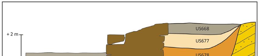
Melis R. et al.
48
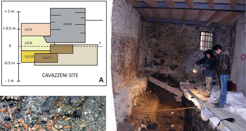
Cavazzeni US120
US76 US76
US74
the level 697T, where the highest
(bottom) (top) richness of the assemblage is report-
depth s.l.m. (m) -0,35 -0,05 +0,25 +0.50
ed. The preservation of the test is
foraminifers % % % % generally poor, above all for A. bec-
Adelosina carinato-striata Wiesner 1,7 carii and E. crispum specimens.
Adelosina sp. 0,5 The ostracod fauna found in
Ammonia beccarii (Limneo) 0,5 9,1 54,5 these samples consists of eight spe-
Ammonia parkinsoniana (d'Orbigny) 0,6 0,5 9,1
cies pertaining to eight genera, which
Ammonia tepida (Cushman) 21,2 20,9 9,1
Aubignyna perlucida (Heron-Allen and Earland) 0,8 1,9
are listed in Table 1. Among them,
Buccella granulata (Di Napoli Alliata) 0,3 Pontocythere turbida, Xestoleberis
Cibicidella variabilis (d'Orbigny) 0,3 communis and Candona neglecta are
Cibicides lobatulus (Walker & Jacob) 0,8 the most common species, even if
Cibicides refulgens Monfort 0,5 they occur with few specimens; other
Cornuspira involvens (Reuss) 1,1
Cribrononion lagunensis Albani & Serandrei Barbero 0,5
taxa such as Aurila arborescens, Le-
Discorbis aguayoi Bermudez 3,9 11,2 ptocythere lagunae, Neocytherideis
Elphidium aculeatum (d’Orbigny) 5,3 5,8 18,2 fasciata and Loxoconcha stellifera are
Elphidium complanatum (d’Orbigny) 3,9 5,8 occasionally present. Callistocythere
Elphidium crispum (Linneo) 18,2 sp. occur only as juveniles. On the
Elphidium excavatum (Terquem) 0,3
whole, the species richness is very
Elphidium jenseni (Cushman) 2,5 10,2 9,1
Elphidium macellum (Fichtel & Moll) 3,1 5,8 27,3 9,1
limited, up to four species in the level
Elphidium pulvereum Todd 28,1 4,4 9,1 US695, whereas on the levels US696
Elphidium punctatum (Terquem) 0,6 and US692 the ostracods are absent.
Haynesina germanica (Ehrenberg) 0,6 The ostracods species identified in
Helenina anderseni (Warren) 1,4 9,1
this sequence are well-known in the
Lachlanella compressa (Wiesner) 0,6
Massilina secans (d’Orbigny) 0,5
modern Mediterranean as representa-
Miliolinella subrotunda (Montagu) 1,1 1,9 tive of freshwater, brackish and ma-
Nonion depressulum (Walker & Jacob) 1,4 rine infralittoral settings; the occur-
Nonion pauciloculum Cushman 1,7 rence of X. communis indicates vege-
Nubecularia lucifuga Defrance 2,2 1,0 tated bottoms.
Quinqueloculina bosciana d’Orbigny 0,3 0,5
Quinqueloculina lata Terquem 0,8 1,0
Quinqueloculina milletti (Wiesner) 0,6 4.2. The “Cavazzeni” site
Quinqueloculina nodulosa Wiesner 0,6 3,9 The archaeological sequence is
Quinqueloculina padana Perconig 0,5 dominated by an imposing wall struc-
Quinqueloculina parvula Schlumberger 3,1 ture, USM4 (Structural stratigraphic
Quinqueloculina seminulum (Linneo) 2,8 1,5
Quinqueloculina spp. 0,6 1,5
unit, e.g. walls, etc.), carried out with
Quinqueloculina ungeriana d'Orbigny 9,1 a carefully structured double para-
Rosalina bradyi (Cushman) 0,6 0,5 ment (and bag filling cement), which
Rosalina floridana (Cushman) 0,8 14,6 are recognized as part of the late an-
Rosalina vilardeboana d'Orbigny 1,7 cient city walls. Its foundational foot,
Sigmoilina costata Schlumberger 0,6
slightly overhanging, which lies at an
Siphonaperta agglutinans (d'Orbigny) 0,3
Triloculina rotunda d'Orbigny 1,9
altitude of 0.0 m m.s.l. with respect to
Trochammina inflata (Montagu) 4,2 2,4 9,1 the current sea level, overlies a large
n° of specimens 359 206 11 11 terraced structure made of large
n° of species 36 26 8 5 blocks of sandstone. The latter was
ostracods n° n° n° n° recognized as a part of the Roman
Candona neglecta (Sars) x x
harbour pier (USM77). Due to the
Candonidae 2x x x
Cytherois frequens G.W. Müller x
small size of the excavation, it is im-
Hemicytherura videns (G.W. Müller) 2 possible to know the structural articu-
Heterocypris salinus (Brady) 1x lation of this coastal structures: only a
Leptocythere lagunae Hartmann 1 small part of the side facing the sea
Loxoconcha affinis (Brady) 2
was identified. It consists in minimum
Loxoconcha elliptica Brady x 3 1x
Loxoconcha rhomboidea (Fischer) x 1
two steps about 0.5 m wide.
Loxoconcha sp. x x x The accurate analysis of the ar-
Schellencandona sp. x 1x 3x x chaeological material, allows to include
Paradoxostoma simile G.W. Müller 1 the US76 in the first half of the 5th cen-
Xestoleberis communis G.W. Müller 2 tury AD. Archaeological data is con-
Xestoleberis plana G.W. Müller x
firmed by radiocarbon dating on Bittium
Tab. 2 - Cavazzeni site: relative abundance of the foraminifera (above) as percentage of reticulatum shell (1550-1580 yrs BP,
each species in respect to the total assemblage; ostracods (below) as number of adult Tab. 4). Similarly, some amphorae
specimens and presence of juveniles is reported with the “x”. fragments recovered in the US120
have been dated at an age ranging
between the end of 4th and the begin-
high percentages. Ammonia tepida, well preserved, are ning of the 5th century AD. The radiocarbon date of a B.
occasionally present (levels US696 and 695), while reticulatum shell found inside the sediment, has pointed
Quinqueloculina spp. and others miliolids occurs only in out an age of 3250 yrs BP (1250 yrs BC, Tab. 4).Sea level and paleoenvironment during Roman times inferred from coastal … 49
E
D Corrected H
C F G I
A B Age measured Predicted height
WGS84 Functional height Palaeo-sea level Vertical tectonic rates
Site name Type of (Years height (Lambeck et al. 2011)
coordinates (m) (m m.s.l.) (mm/yr)
marker BP) (m a.s.l.) (m m.s.l.)
and reference
Sea 45.64861 -0.30.2
Curia 200050 0.3 -0.60.2 -0.46 -0.07
wall 13.7675 This paper
Tab. 3 - Dated sea level markers in Trieste. A) site name; B) type of sea level marker; C) WGS84 centesimal coordinates of the sur-
veyed sites; D) estimated age of archaeological remains (years BP); E) corrected height of the archaeological marker and reference (if
published data); F) functional height; G) paleo-sea level (measured + functional height); H) predicted sea level (from Lambeck et al.,
2011); I) estimated vertical tectonic rate (mm/yr).
In order to study the microfaunistic composition of tum, E. jenseni, E. macellum and Trochammina in-
this paleoenvironments, four levels of the archaeological flata are well represented, even if in low percentage.
sequence have been selected, from the bottom to the In the following level, US76 (bottom), where a slightly
top as follows (fig. 4A): decreasing richness is reported (26 species), the
presence of A. tepida is nearly constant, while an in-
US120: -0.35 m m.s.l.;
creasing percentage of D. aguayoi, E. jenseni and
US76 (bottom): -0.05 m m.s.l.;
Rosalina floridana is evidenced. On the contrary, E.
US76 (top): +0.25 m m.s.l.;
pulvereum strongly decreases at a rate consistent
US74: +0.50 m m.s.l.
with the previous level. In the last two levels, toward
The sedimentary sequence at the “Cavazzeni” site the top of the excavation, the foraminiferal assem-
is characterized by muddy sands rich in gravel. The lat- blage is strongly reduced both in number of species
ter is more abundant toward the top of the excavation. and in number of tests (Tab. 2). Only few specimens
Littoral gastropods are very abundant in the gravelly of Ammonia beccarii, Elphidium crispum, E. macel-
fraction, in particular well preserved specimens of Bit- lum and Quinqueloculina ungeriana are reported.
tium reticulatum (Fig. 4B) and fragments of vegetation in Moreover, these tests are often poorly preserved. It is
the first three levels (US120, US76-bottom and US76- noted that these samples contain reworked older
top); moreover they are enriched of carbonized wood planktonic foraminifers mixed with autochthonous
fragments and archeological fragments toward the top forms; the reworked foraminifers mainly derive from
(US74). the Eocene Flysch bedrock.
The foraminifers found in this excavation ac- The ostracod fauna found in these samples con-
count for forty-four species comprised of twenty-three sists of fourteen species comprised of nine genera.
genera, listed in alphabetic order in Table 2; Ammo- These are listed in alphabetical order in the Table 2.
nia, Elphidium and Quinqueloculina are the most fre- Species of Candona, Schellencandona and Loxoconcha
quent genera. The recovered taxa are well-known in are the most frequent taxa, but usually represented by
the modern Mediterranean coastal areas, from brack- juveniles. In correspondence of the level US76 (bottom),
ish-water to infralittoral settings (see references re- the higher number of species of ostracods is defined by
ported in the Methods). From the bottom (older) to the occurrence of Loxoconcha spp., Xestoleberis spp.,
the top (younger) of the vertical section, the number Heterocypris salinus and Leptocythere lagunae. On the
of species strongly decreases from 36 (level US120) top of the excavation (US74), scattered young speci-
to 5 only (US74). In the first level (US120), Elphidium mens of Candona spp. occur. These species of ostra-
pulvereum and Ammonia tepida are the dominant cods, well-known in the modern Mediterranean, are typ-
species reaching the percentage of 28.13 and 21.17, ically representative of freshwater, brackish, brackish-
respectively (Tab. 2). Other species, such as Milio- infralittoral and infralittoral conditions (see references
lidae, Discorbis aguayoi, E. aculeatum, E. complana- reported in the Methods).
F
C D G
E Age
A B WGS84 Elevation 14 Cal Age 1sigma
Laboratory Number ( C uncal.
Site name Sample coordinates (m a.s.l.) (Years BP)
BP)
Cavazzeni 45.64861
Bittium reticulatum -0.10 Poz-15856 3250 ± 55 3074 87
(US120) 13.7675
Cavazzeni
45.64861
(US76 – Bittium reticulatum -0.05 Poz-15854 2065 ± 30 1639 48
13.7675
bottom)
Cavazzeni
45.64861
(US76 – Bittium reticulatum +0.30 Poz-15855 2020 ± 30 1576 47
13.7675
top)
Tab. 4 - Radiocarbon dating. A) site name and archaeological level; B) sample; C) WGS84 centesimal coordinates of the surveyed sites;
D) elevation of the sample (m m.s.l.); E) laboratory number of the sample; F) uncalibrated age (years BP); G) calibrated age 1sigma
(years BP).Melis R. et al.
50
Fig. 4 - The archaeological site at Cavazzeni. A) Representative sketch of the site; B) Particular of the level US120 with abundant gas-
tropods and C) View of the site.
5. DISCUSSION Adriatic coasts, the studied sites are very significant.
These marine fossils lay above mean sea level, but they
Holocene paleoenvironments of coastal areas are are not directly related to past mean sea levels as they
closely related to sea level and its variations. In particular were probably deposited during a storm event or tsu-
favorable conditions, as in urban environments, the ar- nami. Even if written historical sources of a tsunami in
chaeological structures can preserve sedimentological the Gulf of Trieste have never been found, marine shells
markers which were deposited during their construction dated in the archaeological level US76 - top suggest
or during the employment of coastal artifacts. From a that they can be related to the 361 AD earthquake oc-
geomorphological point of view, all the coastal struc- curred in the Qvarner area (Croatia). A number of Au-
tures found out in Trieste were roughly located at the thors (Pirazzoli, 1980; Benac et al., 2004, 2008), in fact,
Flysch cliff foot, which nowadays is completely covered explained the submerged position of the notch along the
by buildings of the 18th century. The present-day shore- Eastern Adriatic coast indicating the co-seismic move-
line is, in fact, shifted offshore with respect to the Ro- ment related to this earthquake.
man Age one (Fig. 1). Archaeological survey in Trieste highlights a com-
Two coastal archaeological sites recently found out plex Roman Age coastal architecture made up of sea
allowed to reconstruct the Roman Age sea level and its walls, docks and piers connected by a coastal road and
related environment. Moreover, the comparison of sur- functional to a wide urban texture. The construction of
veyed and published data (Ventura et al., 2008) concern- the waterfront was probably the result of a wide project,
ing the site of Cavana provides the trait d’union to support gradually started since the 1st-2nd century AD (Maselli
our thesis concerning Roman Age sea level. Moreover, Scotti, 2008) and subsequently modified time after time
the comparison of their present elevations with predicted up to the 5th century AD. The archaeological setting of
sea level curves (e.g. Lambeck et al., 2011) allowed to the Curia site highlights that significant land reclama-
define the tectonic behaviour of the area. tion have been carried out during Imperial Age too.
The detailed study of archaeological structures From a geomorphological point of view, Roman Age
and the relative stratigraphic sequences found out at the coastal structures have been surveyed in correspond-
studied sites highlighted the occurrence of marine de- ence of the cliff-platform junction. The natural morphol-
posits at an altitude ranging from -0.35 to +0.50 m m.s.l. ogy of the shoreline was probably still visible during
Since no other marine deposits at altitudes higher than Imperial Age, but it was subsequently modified by the
present-day have been found along the whole Eastern following landfills.Sea level and paleoenvironment during Roman times inferred from coastal … 51
Fig. 5 - Representative sketch of the relations among the archaeological sites at Cavazzeni, Cavana and Curia.
The composition of the foraminiferal assemblage spp., Xestoleberis spp. and Hemicytherura videns
of marine deposits at the base of the wall suggests a among the ostracods. The occurrence of epiphytic
high energy shallow marine environment, as highlighted species such as Elphidium spp., Rosalina spp. and
by the dominance of A. beccarii and E. crispum, whom Discorbis aguayoi, indicates the highly vegetate condi-
specimens are both well and poorly preserved. The as- tions of the bottom, whom remains are abundant in the
sociation with some epiphytic forms, such as E. aculea- studied sediments. In particular, D. aguayoi has been
tum and E. pulvereum, indicates some vegetation cover. frequently found on Zoostera noltii leaves (Hohe-
The stratigraphical sequence seems to indicate the negger et al., 1989). This marine paleoenvironment is
presence of a sandy bar (US699) which separates an influenced by salinity variability, as indicated by the
inner environment (US696) and an outer one (US697). occurrence of A. tepida (> 20% of frequency), A. per-
Only level US697T (-0.15 m.s.l.) is indicative of an open lucida, Haynesina spp. and T. inflata, which are spe-
marine setting. Scattered occurrence of brackish taxa cies of brackish-water affinity characteristic of lagoon,
such as A. tepida, E. excavatum, N. pauciloculum sug- estuarine, or river-mouth environments. The fresh wa-
gests a slight influence of freshwater input. The ostra- ter input is testified also by the presence of ostracods
cods, which are generally scarce or absent, confirm this such as Candona spp., which is exclusive of lake set-
paleoenvironmental interpretation. tings. Probably in this shallow coastal environment,
Afterward, the Imperial Age harbour system suf- highly vegetated, fresh water may also accumulate
fered a widespread crisis during the Late Roman Age from small streams or from human harbour activities.
(Ventura et al., 2008) so important as to remain out of Considering the good preservation of the microfossils
the 5th century defensive system of the city. Later, ar- and the abundance of vegetation, it is possible to as-
chaeological and micropaleontological data indicate the sume that it was a partially protected environment,
prograding of the coastline created through the accumu- maybe a small harbour. In fact, the high occurrence in
lation of filling material (from US692 upward). all the studied levels, but one (US74), of B. reticula-
Late Roman Age coastal structures which overlay tum, which is a marine infralittoral gastropod, could
an Imperial Age pier have been discovered at
Cavazzeni (Fig. 4, Maselli Scotti, 2008;
Degrassi et al., 2008). The pier could be simi-
lar to fluvial dock structures found out at Alti-
no (Venice, Italy, Tirelli, 2001), where the flu-
vial port was terraced, as in Trieste, and cou-
plet with wood poles, used for docking and
protection of the dock itself (Tirelli, 2001).
Even if the portuality and the harbour envi-
ronment of Trieste was necessarily different,
Roman Age oak poles have been found near
the Cavazzeni site (Ventura, 1996).
Regarding the Cavazzeni site, the mi-
crofaunae composition of the levels US120
and US76 (bottom), which are located from
–0.35 to –0.05 m m.s.l., represents a shal-
low-marine infralittoral paleoenvironment, as
testified by several species of miliolids and
other marine hyaline taxa among the fora- Fig. 6 - Predicted sea level curve (Lambeck et al., 2011) compared with the
minifers, and by species of Loxoconcha elevation of the sea level markers quoted in Table 3.Melis R. et al.
52
indicate a limited confinement of this area. The accu- 6. CONCLUSIONS
mulation of these shells could be due to the backwash
action. 17th century maps (Fig. 2) highlight the pres- A detailed analysis of published and new data on
ence of piers and breakwaters which created sheltered archaeological remains and sedimentological deposits
areas behind them along almost the waterfront. Dating at two archaeological sites in Trieste allowed to recon-
of pottery sherds and ceramics found out at the stud- struct the paleoenvironment and the sea level during
ied sites agree with the radiocarbon age on marine Roman Age. At that time, the shoreline was already
shells found out in the same deposits. In the upper part strongly affected by human activities, as testified by the
of the sequence (US76 - top and US74, from +0.25 to presence of well-developed coastal structures. After-
+0.50 m m.s.l.), very few foraminifers always badly wards, these structures were covered by 17th century
preserved are recovered; they are represented by reclamation works. Archaeological and micropaleontolo-
coastal marine taxa of high hydrodynamics such as A. gical data indicate that Roman Age sea level was -
beccarii, A. parkinsoniana and E. crispum, E. macel- 0.6±0.2 m lower than nowadays. Therefore the compar-
lum, probably transported by violent storm episodes ison between past sea level and the predicted sea level
and accumulated in this confined basin or representing curve (Lambeck et al., 2011) suggests that this sector of
a non-protected coastline. Ostracods are very scarce the Gulf of Trieste has been affected by a vertical tec-
and are represented only by juveniles of freshwater tonic downlift of about -0.2 mm/yr since Roman Age.
species. Archaeological materials indicate that the lev- These data disagree with the higher tectonic subsidence
el US74 probably represents a landfill. observed along the remaining part of the Northern Adri-
The archaeological setting of the two sites and atic Sea (Antonioli et al., 2007).
the comparison with data collected at Cavana (Fig. 1, The presence of marine deposits with bad-
5; Ventura et al., 2008; Degrassi et al., 2008) suggests preserved microfossils at elevations higher than current
the presence of marine deposits in all the studied mean sea level suggests the possible occurrence of a
sites. Thanks to the presence of coastal deposits and violent storm or a tsunami event. Radiocarbon dating
the joint analysis of both archaeological remains, mi- suggests a correlation with the 361 AD earthquake oc-
cropaleontological data and radiocarbon dating of ma- curred along the Eastern Adriatic coasts. This earth-
rine shells, sea level change in the study area was quake was considered as the driving factor in the origin
evaluated. Regarding the Curia site, even if the ar- of the submerged notch in the same area by Pirazzoli
chaeological structure is poor of information, the pre- (1980) and Benac et al. (2004, 2008).
sence of a beach deposit located at the base of the
coastal wall reduces the errors related to the Roman Acknowledgements
Age sea level height. In particular, we compared the We are kindly grateful to Prof. Nevio Pugliese, De-
archaeological structure to current retaining sea walls partment of Mathematics and Geosciences, University
scattered along the shoreline Northward from Trieste. of Trieste, for micropaleontological advices. Moreover
Their base is located averagely 0.3 m above mean sea we thank two anonymous reviewers for the useful ad-
level. According to the hypothetical similarity between vices.
present-day and ancient sea walls, we suggest that
Roman Age functionality of the studied sea wall was REFERENCES
about 0.3 m (Tab. 3). Considering an elevation uncer-
tainty of +0.2 m, Roman sea level was therefore at Albani A.D., Favero V., Serandrei Barbero R. (1991) -
about -0.6±0.2 m m.s.l. Afterwards, these structures The distribution and ecological significance of re-
and the related coastal deposits were covered by filling cent Foraminifera in the lagoon south of Venice
materials, in order to create a new waterfront, moved (Italy). Revista Española de Micropaleontologia,
off-shore (Fig. 2). On the contrary, due to the small 23, 29-45.
size of the excavation, it is more difficult to evaluate Albani A.D., Serandrei Barbero R. (1990) - I foraminiferi
the role and consequently the functionality of Imperial della Laguna e del Golfo di Venezia. Memorie di
Age structures at Cavazzeni. Therefore it is impossible Scienze Geologiche, 42, 271-341.
to evaluate the sea level change which occurred since Amato L., Guastaferro C., Cinque A., di Donato V., Ro-
the time of their construction. mano P., Ruello M.R., Perriello Zampelli S., Mo-
Degrassi et al. (2008) suggested two hypothesis rhange C., Russo Ermolli E., Irollo G., Carsana V.,
concerning sea level change in the area. The first hy- Giampaola D. (2009) - Ricostruzioni morfoevoluti-
pothesis assumes the tectonic stability, while the latter ve nel territorio di Napoli. L’evoluzione tardo plei-
assumes the vertical downdrop, in agreement with the stocenica-olocenica e le linee di riva di epoca sto-
whole Eastern Adriatic coast. Thank to the availability of rica. Méditerranée, 112, 23-31.
new archaeological and micropaleontological data at Antonioli F., Amorosi A., Bondesan A., Braitenberg C.,
Curia site, we support the first hypothesis. In fact, the Dutton A., Ferranti L., Fontana A., Fontolan G.,
comparison of surveyed data and predicted curves (An- Furlani S., Lambeck K., Mastronuzzi G., Monaco
tonioli et al. 2007; Lambeck et al., 2011) suggests that C., Orrù P. (2009) - A review of the Holocene sea-
limited relative sea level variations occurred since Ro- level changes and tectonic movements along the
man Age (Fig. 6), despite the significant tectonic sub- Italian coastline. Quaternary International, 206 (1-
sidence of the Eastern and Northern Adriatic coast (An- 2), 102-133.
tonioli et al., 2007; Faivre et al., 2011). Data here dis- Antonioli F., Anzidei M., Lambeck K., Auriemma R.,
cussed confirm the tectonic peculiarity of the Trieste ar- Gaddi D., Furlani S., Orrù P., Solinas E., Gaspari
ea suggested by Furlani et al. (2011) with respect to the A., Karinja S., Kovacic´ V., Surace L. (2007) - Sea
surrounding area. level change during Holocene from Sardinia andSea level and paleoenvironment during Roman times inferred from coastal … 53
northeastern Adriatic (Central Mediterranean sea) bottom sediments of the Adriatic Sea. Vrije Universi-
from archaeological and geomorphological data. teit te Amsterdam, Academisch Preefscrift, 1-165.
Quaternary Science Reviews, 26, 2463-2485. Busetti M., Volpi V., Barison E., Giustiniani M., Marchi M.,
Antonioli F., Carulli G.B., Furlani S., Auriemma R., Ma- Ramella R., Wardell N., Zanolla C. (2008) - Ceno-
rocco R. (2004) - The enigma of submerged ma- zoic seismic stratigraphy and tectonic evolution of
rine notches in northern Adriatic Sea. Quaternaria, the Gulf of Trieste (Northern Adriatic). Proceed-
8, 27-36. ings of the “ADRIA 2006 - International Geological
Antonioli F., Furlani S. (2006) - Geomorphological evi- Congress on Adriatic area”, Urbino (Italy), 19-20
dences due to recent tsunami (or large storms) in May 2006, GeoActa, Special Publication, 3, 15-28.
Istria. International Geological Congress On The Busetti M., Volpi V., Nicolich R., Barison E., Romeo R.,
Adriatic Area, 19-20 June 2006 Urbino, Abstract, Baradello L., Brancatelli G., Giustiniani M., Marchi
4-6. M., Zanolla C., Nieto D., Ramella R., Wardell N.
Athersuch J. (1979) - The ecology and distribution of the (2010) - Dinaric tectonic features in the Gulf of Tri-
littoral ostracods of Cyprus. Journal of Natural este (Northern Adriatic). Proceedings of the "27°
History, 13, 135-160. Convegno Nazionale del Gruppo Nazionale di
Auriemma R., Solinas E. (2009) - Archaeological re- Geofisica della Terra Solida (GNGTS)", Trieste
mains as sea level change markers: A review. (Italy), 6-8 October 2008, Bollettino di Geofisica
Quaternary International, 206 (1-2), 134-146. Teorica e Applicata, 51(2-3), 117-128.
Barbeito Gonzalez P.J. (1971) - Die Ostracoden des Carobene L., Carulli G.B. (1981) - Fogli 40A Gorizia e
Küstenbereiches von Naxos (Griechenland) und 53A Trieste. In: Castellarin A. (a cura di), Carta tet-
ihre Lebensbereiche. Mitteilungen Hamburg Zoo- tonica delle Alpi Meridionali (alla scala 1:2000.000).
logischen Museum und Institut, 67, 255-326. Pubbl.441, P.F. Geodinamica (S.P. 5), C.N.R., 8-
Bellotti P., Carboni M.G., Di Bella L., Palagi I., Valeri P. 13.
(1994) - Benthic foraminiferal assemblages in the Carulli G.B. (2011) - Structural model of the Trieste Gulf:
depositional sequence of the Tiber Delta. Bolletti- A proposal. Journal of Geodynamics, 51, 156-165.
no della Società Paleontologica Italiana, 2, 29-40. Castellarin A., Cantelli L., Fesce A.M., Mercier J.L., Pi-
Benac Č., Juračić M., Bacran-Petricioli T. (2004) - Sub- cotti V., Pini G.A., Prosser G., Selli L. (1992) - Al-
merged tidal notches in the Rijeka Bay NE Adriatic pine compressional tectonics in the Southern Alps.
Sea: indicators of relative sea-level change and of Relationship with the N-Apennines. Annales Tec-
recent tectonic movements. Marine Geology 212 tonicae, 6(1), 62-94.
(1-4), 21-33. Cavallin A., Martinis B., Carobene L., Carulli G.B. (1978)
Benac Č., Juračić M., Blašković I., (2008) - Tidal notch- - Dati preliminari sulla Neotettonica dei Fogli 25
es in Vinodol Channel and Bakar Bay, NE Adriatic (Udine) e 40A (Gorizia). Contributi preliminari alla
Sea: Indicators of recent tectonics. Marine Geolo- realizzazione della carta neotettonica d’Italia. CNR
gy 248 (3-4), 151-160. e Progetto Finalizzato Geodinamica, Pubbl. 155,
Bensi S., Fanucci F., Pavsic J., Tunis G., Cucchi F. 189-197.
(2007) - Nuovi dati biostratigrafici, sedimentologici Cimerman F., Langer M.R. (1991) - Mediterranean Fo-
e tettonici sul Flysch di Trieste. Rendiconti Società raminifera. Slovenska Akademija Znanosti in
Geologica Italiana, 4, 145. Umetnosti. Opera Academia Scientiarium et Ar-
Bernasconi M.P., Melis R., Pugliese N., Stanley D.J., tium Slovenica, Classis 4, Historia Naturalis, 30,
Bandelli A. (2007) - Faunal analyses in the inter- 118.
pretation of the submergence of substrates be- Coren F., Marson I., Creati N., Prodan M., Palmieri F.,
neath Herakleion and Eastern Canopus. In: Stan- Zanolla C. (2006) - Structural setting of the Trieste
ley D.J. et al. (eds.) “Underwater archaeology in area from gravity modelling. Bollettino di Geofisica
the Canopic region in Egypt, Geoarchaeology”. Teorica ed Applicata, 47(4), 549-555.
Oxford Centre for Marit. Archeol.: monogr. 2, Univ. Cucchi F., Pugliese N. (2000) - Successione stratigrafi-
of Oxford, 59-86. ca, Il Carso triestino. In: Carulli G.B. (Ed.) 2000.
Bernasconi M.P., Melis R., Stanley D.J. (2006) - Benthic Società Geologica 80° Riunione estiva, Guida alle
biofacies to interpret Holocene paleoenvironmen- escursioni, 207-213.
tal changes and human impact in Alexandria's D’Ambrosi, C. (1958) - Recenti misure mareografiche
Eastern Harbor, Egypt. The Holocene, 16 (8), confermerebbero il persistere di tendenze epiro-
1163-1176. genetiche in Istria. Boll. Soc. Adriat. Sci. Nat., 50,
Bernasconi M., Stanley J.D., Caruso C. (2010) - Syba- 9-25.
ris-Thuri-Copia deltaic settings in Calabria, Italy: della Croce I. (1698) - Historia antica, e moderna, e sa-
Molluscs, associated biogenic components, and cra, e profana, della città di Trieste, Venetia.
ecobiostratigraphy applied to archaeology. Journal Degrassi A. (1957) - I porti romani dell’Istria. Anthemon,
of Coastal Research, 26(2), 377-390. Firenze, 119-169.
Bonaduce G., Ciampo G., Masoli M. (1975) - Distribu- Degrassi V., Furlani S., Scotti F.M., Melis R., Antonioli
tion of Ostracoda in the Adriatic Sea. Pubblicazioni F., Fonda G. (2008) - Strutture portuali di Via dei
della Stazione Zoologica di Napoli, 40, 1-304. Cavazzeni (Trieste): indicazioni sul livello del ma-
Braitenberg C., Nagy I., Romeo G., Taccetti Q. (2005) - re. Terre di mare. L’archeologia dei paesaggi co-
The very broad-band data acquisition of the long- stieri e le variazioni climatiche. Auriemma R. & Ka-
base tiltmeters of Grotta Gigante (Trieste, Italy). rinja S. (Eds), Udine, Atti del Convegno Interreg
Journal of Geodynamics, 41, 164-174. Internazionale di Studi, Trieste, 8-10 novembre
Breman E. (1975) - The distribution of ostracodes in the 2007, 275-281.Melis R. et al.
54
Di Bella L., Bellotti P., Frezza V., Bergamin L., Carboni level rise. Earth and Planetary Science Letters,
M.G. (2011) - Benthic foraminiferal assemblages 224, 563-575.
of the imperial harbor of Claudius (Rome): Further Le Calvez J., Le Calvez Y. (1958) - Repartition des Fo-
paleoenvironmental and geoarcheological eviden- raminifères dans la Baie de Villefranche. Annales
ces. The Holocene, 21 (8), 1243 - 1257. de l’Institut Océanographique, 35, 159-234.
Doglioni C., Bosellini A. (1987) - Eoalpine and mesoal- Levy A., Mathieu R., Poignant A., Rosset-Moulinier M.
pine tectonics in the Southern Alps. Geologische (1992) - Foraminifers à arrangement quinquelocu-
Rundschau 76 (3), 735-754. lin et triloculin (Miliolacea) de Méditerranée. Revue
Donnici S., Serandrei Barbero R. (2002) - The benthic de Paléobiologie, 11 (1), 111-135.
foraminiferal communities of the northern Adriatic Marriner N., Morhange C. (2007) - Geoscience of an-
continental shelf. Marine Micropaleontology, 44 (3- cient Mediterranean harbour. Earth Science Revi-
4), 93-123. ew, 80, 137-194.
Faivre S., Fouache E., Ghilardi M., Antonioli F., Furlani Maselli Scotti F. (2008) - Il porto di Tergeste: riflessioni a
S., Kovačić V. (2011) - Relative sea level change seguito dei recenti rinvenimenti. Terre di mare.
in Istria (Croatia) during the last 5 ka. Quaternary L’archeologia dei paesaggi costieri e le variazioni
International, 232, 132-143. climatiche. Auriemma R. & Karinja S. (Eds), Udi-
Fiorini F., Vaiani S.C. (2001) - Benthic foraminifers and ne, Atti del Convegno Interreg Internazionale di
transgressive-regressive cycles in the Late Qua- Studi, Trieste, 8-10 novembre 2007, 317-327.
ternary subsurface sediments of the Po Plain near Mazzini I., Faranda C., Giardini M., Giraudi C., Sadori L.
Ravenna (Northern Italy). Bollettino della Società (2011) - Late Holocene paleoenvironmental evolu-
Paleontologica Italiana, 40 (3), 357-403. tion of the Roman harbour of Portus, Italy. Journal
Fouache E., Faivre S., Dufaure J-J., Kovačić V., Tas- of Paleolimnology, 46, 243-256
saux F. (2000) - New observations on the evolu- Meisch C. (2000) - Freshwater ostracoda of Western
tion of the Croatian shoreline between Poreč and and Central Europe. In: Schwoerbel J., Zwick P.
Zadar over the past 2000 years. Zeitschrift für Ge- (eds.) Sűsswasserfauna von Mitteleuropa 8/3.
omorphologie Suppl.-Bd. 122, 33-46. Spektrum Akademischer Verlag, Heidelberg, 1-
Furlani S., Biolchi S., Cucchi F., Antonioli F., Busetti M., 522.
Melis R. (2011) - Tectonic effects on Late-Holocene Montenegro M.E., Pugliese N., Bonaduce G. (1998) -
sea level changes in the Gulf of Trieste (NE Adriatic Shelf ostracods distribution in the Italian seas. In:
Sea, Italy). Quaternary International, 232, 144-157. “What about Ostracoda? Actes 3e Congrès Euro-
Ghilardi M., Genc A., Syrides G., Bloemendal J., Psomi- péen des Ostracodologistes, Paris-Bierville,
adis D., Paraschou T., Kunesh S., Fouache E. France, 1996” - Bullétin Centre Recherches Elf
(2011) - Reconstruction of the landscape history Exploration Production, Mémoire, Pau, 20, 91-101.
around the remnant arch of the Klidhi Roman Pérès J.M. (1982) - Major benthic assemblages. Kinne
Bridge, Thessaloniki Plain, North Central Greece. O. (Eds) Marine Ecology. John Wiley & Sons Ltd.,
Journal of Archaeological Science, 37, 178-191. Chichester, 5 (1), 373-522.
Goiran J.P., Marriner N., Morhange C., Abd el-Maguib Pérès J.M., Picard J. (1964) - Nouveau manuel de bio-
M., Espic K., Bourcier M., Carbonel P. (2005) - nomie benthique de la Mer Méditerranée. Recueil
Évolution géomorphologique de la façade mari- des Travaux, Station Marine d'Endoume, 31, 1-
time d'Alexandrie (Égypte) au cours des six der- 137.
niers millénaires. Méditerranée, 104, 61-64. Pirazzoli P.A. (1980) - Formes de corrosion marine et
Hohenegger J., Piller W., Baal Ch. (1989) - Reasons for vestiges archeologique submerges: interpretation
the spatial microdistributions of foraminifers in an neotectonique de quelques exemples en Grece et
intertidal pool (Northern Adriatic Sea). P.S.Z.N. I. en Yougoslavie. Annals de l’Institut de Ocea-
Marine Ecology, 10, 43-78. nographique, 56, 101-111.
Hottinger L., Halicz E., Reiss Z. (1993) - Recent Pirazzoli P.A. (1996) - Sea-Level Changes. The Last
foraminiferida from the gulf of Aqaba, Red Sea. 20000 Years. John Wiley and Sons Ltd., Chiches-
Slovenska Akademija Znanosti in Umetnosti. Ope- ter, 211.
ra Academia Scientiarium et Artium Slovenica, Pugliese N., Maselli Scotti F., Franchini D. (1999) - Mi-
Classis 4, Historia Naturalis, 33, 179. cropalaeontology in archaeology research: draft of
Jorissen F.J. (1988) - Benthic foraminifera from the late Quaternary evolution of the alluvial plain near
Adriatic Sea: principles of phenotypic variation. Aquileia (NE Italy). Revista Espanola de Micropale-
Utrecht Micropaleontological Bulletin, 37, 174. ontologia, 31(3), 403-410.
Lambeck K., Antonioli F., Anzidei M., Ferranti L., Leoni Pugliese N., Stanley D.J. (1991) - Ostracoda, deposi-
G., Scicchitano G., Silenzi S. (2011) - Sea level tional environments and late Quaternary evolution
change along the Italian coast during the Holo- of the eastern Nile Delta, Egypt. Il Quaternario,
cene and projections for the future. Quanternary 4(2), 275-302.
International, 232, 250-257. Reinhardt E.G., Patterson R.T., Schröeder-Adams C.J.
Lambeck K., Antonioli F., Purcell A., Silenzi S. (2004a) - (1994) - Geoarchaeology of the ancient harbour
Sea level change along the Italian coast for the site of Caesarea Maritima, Israel: evidence from
past 10,000 yrs. Quaternary Science Reviews, 23, sedimentology and paleoecology of benthic fora-
1567-1598. minifera. Journal of Foraminiferal Research,
Lambeck K., Anzidei M., Antonioli F., Benini A., Esposito 24(1), 37-48.
E. (2004b) - Sea level in Roman time in the central Riavez P. (1995) - Il porto antico di Trieste. Osservazio-
Mediterranean and implications for modern sea ni sulle strutture portuali attestate nella zona diYou can also read