The North American Extended Range Weather Outlook Winter-Summer 2019 - Dr. Art Douglas
←
→
Page content transcription
If your browser does not render page correctly, please read the page content below
The North American
Extended Range Weather Outlook
      Winter-Summer 2019

           Dr. Art Douglas
 Professor Emeritus Creighton University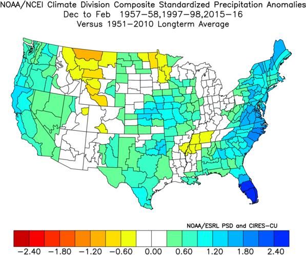
Outline

1. The El Nino is moving forward.

2. The North American Weather
   Outlook for Winter-Summer 2019.
The Cross Equatorial Flow Index (CEFI)
The CEFI index measures the pressure                        NOAA CFSv2 forecast
gradient between Easter Island and Liberia                  Nino 1&2 off Peru
in Costa Rica. From early October to early
November the index fell indicating Pacific
                                                                                       M
Trade Winds were weakening allowing El
                                                                                       A
Nino to build. The most recent NOAA                                                    Y
forecast shows the current warming into
December and additional warming in May.
                              Pressure Difference
                       Easter Island Minus Liberia, Costa
                                      Rica
                  20
Difference (mb)

                  18
                  16                                          La Nina Develops >12mb
                  14
                  12
                  10
                   8                                          El Nino Develops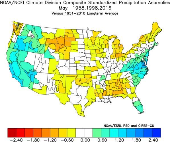
World SST Anomalies on November 22, 2018
El Nino warming extends from the Dateline to the coast of Peru. Anomalies are
approaching levels associated with a moderate El Nino event. Warm waters in the
Pacific south of Hawaii will drive a strong Subtropical Jetstream towards the U.S.
while the temperature gradient in the North Atlantic will strengthen the Polar
Jetstream in the eastern U.S.
NOAA and ECMWF El Nino
     Forecasts through
       Summer 2019
The most recent runs of the CFSv2                         M
(blue lines upper graph) indicate the   NOAA CFSv2        A
                                                          Y
warming event will peak in              Nov 25 2018
December near +1.2C. The ECMWF
forecast issued on November 1st is
similar to the NOAA model. Both
models show a second warming
phase in April which will keep spring
storms across the Southwest and
northern Mexico. El Nino conditions
are now forecast into the summer.
                                                      A
                                                      P
                                         ECMWF
                                                      R
                                         Nov 1 2018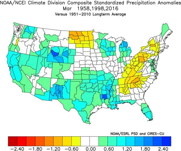
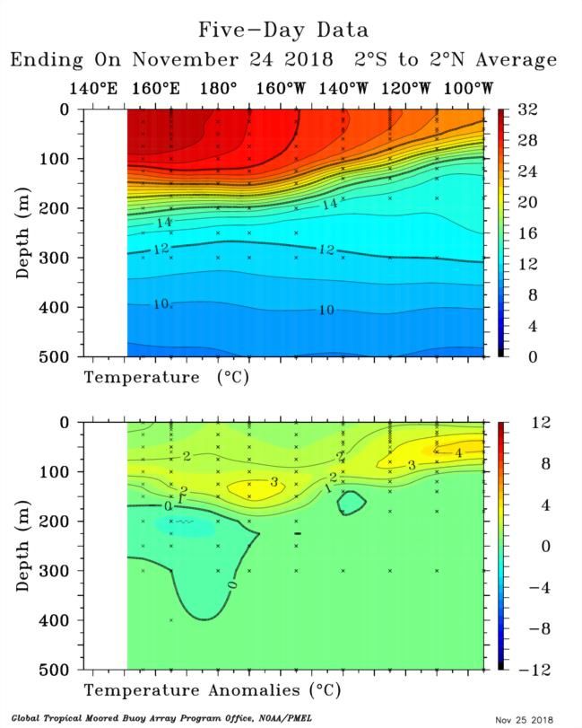
Internal Ocean Wave
 Moving East Towards Peru
An internal ocean wave in the
West Pacific is moving towards
Peru. The wave was release
with the weakened trade winds
off South America and a burst    SE ASIA Dateline   PERU
of westerly wind coming into
the Pacific from the Indian
Ocean. Warm water off Peru is
associated with the weakened
trade winds during October and
early November. El Nino is
firmly in place.

                                 SE ASIA Dateline   PERU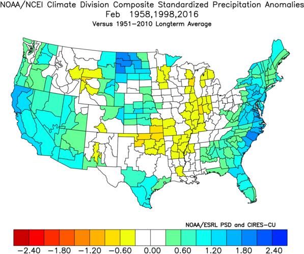
Outline

1. The El Nino is moving forward.

2. The Weather Outlook for
   Winter-Summer 2019.
November 2018 Climate
 Indices: 700mb Height
Anomalies (top) and SST
   Anomalies (bottom)
After a stormy October in
the Pacific the main
activity shifted to the East
                               NOV. 700mb HTS
and North Atlantic in
November. Strong SST
gradients in the Atlantic
will continue to fuel
storms. El Nino warmth is
evident across the Pacific
with SSTs in the Gulf of
Alaska close to the highest
on record. A ridge of high
pressure has protected the
warm ocean going into the
winter, but this will          NOV. SSTs
change.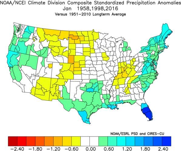
Equatorial Pacific SSTs 160°E to 78°W

   Equatorial Pacific SSTs   8th or 9th Warmest
The warm Gulf of Alaska SSTs will
fuel a strong trough and polar jet
aimed at the West Coast of the
U.S.
                                                 Gulf Alaska
The warm SSTs south of Hawaii                    SSTs 1st
will fuel a strong subtropical jet
aimed at western Mexico.

                  Hawaii SSTs 3rd

                                     NOV. SSTs
Cold waters off Greenland
combined with warm
Greenland SSTs
waters in the North 20th
Atlantic near 45°N will
team up to create a strong
trough and polar jet across
the North Atlantic.
NW Atlantic SSTs
4th
NOV. SSTsThe December 2018 Analog Forecast The top 9 years for consideration in the Analog Forecast are El Nino events. El Nino events generally derive their forecast accuracy from SST impacts on the general circulation. THIS YEAR IS A BIG EXCEPTION. The 700mb height patterns (HGT) show the best correlations with 2018 . It appears that the general circulation is in an El Nino mode and that Atlantic and Pacific SSTs will eventually evolve towards an El Nino SST pattern. Watch out for 1989!! YEAR BASE SST HGTS NO_ATL SUM STATUS Y14 0.69 0.56 0.89 0.53 2.67EL NINO Y89 0.64 0.61 0.67 0.36 2.28OUCH Y02 0.34 -0.10 0.97 -0.01 1.20EL NINO Y15 0.50 0.62 -0.12 0.20 1.20EL NINO Y86 0.30 0.23 0.81 -0.16 1.18EL NINO Y78 0.19 0.29 0.24 0.39 1.11EL NINO Y68 0.16 -0.12 0.76 0.03 0.83EL NINO Y97 0.02 -0.32 0.97 -0.11 0.56EL NINO Y57 0.03 -0.13 0.70 -0.05 0.55EL NINO
GFS TEMPERATURES DECEMBER 3-11, 2018

DEC 1989

                 DECEMBER 2018 HEIGHT ANOMALIES
                 FROM THE CFSv2 MODEL RUN 11/24/18

JAN FEB 1990
The Analog Forecast of 700mb Height Anomalies for Winter 2019
The main storm track will be out of the Pacific into the Southwest. As storms
move in the Gulf of Mexico they will regenerate, and this will cause increased
cloud cover, heavy precipitation and cool daytime temperatures in the
southern tier of states. The Canadian ridge will favor an open winter up north.
There has been about a
30-40% turn over in the
analog years over the
past 4 forecasts, yet the
pressure patterns have
been persistent in the
forecasts with a deep
North Pacific trough and
warm ridging across
Canada.
WINTER 700MB HEIGHT ANOMALIES
Last 3 Month’s Winter 700MB HEIGHT ANOMALIESThe Winter 2019 Analog Forecast
A warm winter across the country continues to be forecast. This will help
winter wheat in the plains. El Nino moisture continues to be forecast from
Arizona into the Southeast and the new forecast is even more bullish with the
moisture in the plains and Southeast. It appears the analog forecast is moving
the main storm track a bit farther east than previous forecast.
Winter Temperature Winter Precipitation
Previous
Month’sNorth American Winter 2019 Analog Forecast
Positive height anomalies in Canada will limit cold air from moving south. An
active storm track across northern Mexico will keep the Meseta cooler than
normal. Precipitation will trend normal to above normal across Mexico with
the southwest coast the wettest location.
TEMPERATURE PRECIPITATIONMonth-by-Month
Breakdown in Winter
Temperatures and
Precipitation
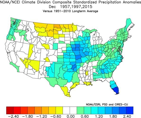
TEMP Dec PRECIP Dec
The new analog forecast
keeps the warm trend
across the north and the
active storm track into the
Southwest. Exact timing of
shifts in the heaviest TEMP Jan PRECIP Jan
precipitation will be difficult
to forecast given the
unstable jet stream pattern
across North America and
the Atlantic.
TEMP Feb PRECIP FebThe Analog Forecast of 700mb Height Anomalies
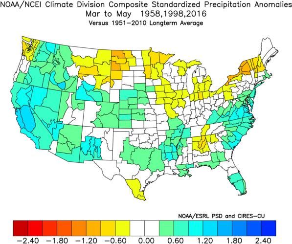
Spring 2019
The Pacific storm track will tap into warm waters near the dateline and this will
direct storms across the Pacific towards the Southwest. High pressure ridging
in Canada will block Arctic cold from plunging south.
SPRING 700MB HEIGHT ANOMALIES
Last Months’
ForecastsThe Spring 2019 Analog Forecast
The new analog forecast is cooler and wetter in the southwest quarter of the
country in the spring. The Canadian border region will be warmer and drier
through the spring as the two main storm tracks stay far north and far south of the
border. March could be a problematic month in the central plains with late snows
and cold.
Spring Temperature Spring Precipitation
Previous MonthsNorth American Spring 2019 Analog Forecast
A storm track into northern Mexico will create cool weather from Baja
California to Nuevo Leon. Precipitation will trend above normal from the
Meseta to Tamaulipas but below normal precipitation and above normal
temperatures will stretch across southeast Mexico.
TEMPERATURE PRECIPITATIONMonth-by-Month
Breakdown in Spring
Temperatures and
Precipitation
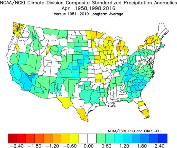
TEMP Mar PRECIP Mar
A storm track across the
Southwest will keep that
region cooler and wetter
than normal through mid
spring. Moisture will be
plentiful through the plains
into the Gulf Coast. The TEMP Apr PRECIP Apr
current analog forecast is
much wetter in California
with very warm SSTs south
of Hawaii expected to fuel
storms reaching the coast.
May will transition to
warmer-drier weather. TEMP May PRECIP MayThe Analog Forecast of 700mb Height Anomalies
Summer 2019
High Pressure ridging will return to the North Pacific and this could fuel a new
warming phase and possible return of El Nino in 2019-20. A trough is forecast
across the Great Lakes and this will favor mild-wet weather in the Midwest.
High pressure ridging in the south will result in warm summer temperatures.
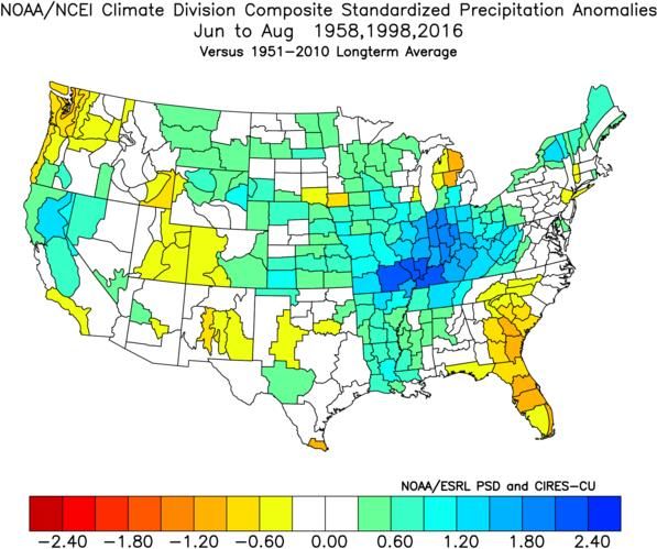
SUMMER 700MB HEIGHT ANOMALIESThe Summer 2019 Analog Forecast
High pressure ridging in the Pacific will warm the West. The trough in the Great
Lakes will favor wet weather through most of the corn belt. The analog forecast
calls for high pressure ridging in the South and this needs to be watched per the
development of flash drought conditions in the southern plains and southeast.
Summer Temperature Summer Precipitation
Last Month’s’
ForecastNorth American Summer 2019 Analog Forecast
The summer forecast is being dominated by the analog year of 1998 when a
strong ridge of high pressure developed over northern Mexico. Hot-dry
weather occurs through the northern two-thirds of Mexico. Evolving weather
conditions will need to be monitored in the spring to determine the possibility
of a repeat of the 1998 early summer drought and late start to the monsoon.
TEMPERATURE PRECIPITATIONYou can also read