Decadal Seismicity before Great Earthquakes-Strike-Slip Faults and Plate Interiors: Major Asperities and Low-Coupling Zones
←
→
Page content transcription
If your browser does not render page correctly, please read the page content below
International Journal of Geosciences, 2021, 12, 784-833
                                                                                                   https://www.scirp.org/journal/ijg
                                                                                                            ISSN Online: 2156-8367
                                                                                                              ISSN Print: 2156-8359

Decadal Seismicity before Great
Earthquakes—Strike-Slip Faults
and Plate Interiors: Major Asperities
and Low-Coupling Zones

Lynn R. Sykes

Lamont-Doherty Earth Observatory of Columbia University, Palisades, New York, USA

How to cite this paper: Sykes, L.R. (2021)     Abstract
Decadal Seismicity before Great Earth-
quakes—Strike-Slip Faults and Plate Inte-      Decadal forerunning seismic activity is examined for very large, shallow earth-
riors: Major Asperities and Low-Coupling       quakes along strike-slip and intraplate faults of the world. It includes fore-
Zones. International Journal of Geosciences,
                                               running shocks of magnitude Mw ≥ 5.0 for 21 mainshocks of Mw 7.5 to 8.6
12, 784-833.
https://doi.org/10.4236/ijg.2021.129044        from 1989 to 2020. Much forerunning activity occurred at what are inter-
                                               preted to be smaller asperities along the peripheries of the rupture zones of
Received: August 4, 2021                       great mainshocks at transform faults and subduction zones. Several great as-
Accepted: September 11, 2021
                                               perities as ascertained from forerunning activity agree with the areas of high
Published: September 14, 2021
                                               seismic slip as determined by others using geodetic, mapping of surface fault-
Copyright © 2021 by author(s) and              ing, and finite-source seismic modeling. The zones of high slip in many great
Scientific Research Publishing Inc.            earthquakes were nearly quiescent beforehand and are identified as the sites
This work is licensed under the Creative
                                               of great asperities. Asperities are strong, well-coupled portions of plate inter-
Commons Attribution International
License (CC BY 4.0).                           faces. Different patterns of forerunning activity on time scales of up to 45
http://creativecommons.org/licenses/by/4.0/    years are attributed to the sizes and spacing of asperities (or lack of). This
                Open Access                    permits at least some great asperities along transform faults to be mapped
                                               decades before they rupture in great shocks. Rupture zones of many great
                                               mainshocks along transform faults are bordered either along strike, at depth
                                               or regionally by zones of lower plate coupling including either fault creep
                                               forerunning activity, aftershocks and/or slow-slip events. Forerunning activi-
                                               ty to transforms in continental areas is more widespread spatially than that
                                               adjacent to oceanic transforms. The parts of the San Andreas fault themselves
                                               that ruptured in great California earthquakes during 1812, 1857 and 1906
                                               have been very quiet since 1920; moderate to large shocks have been concen-
                                               trated on their peripheries. The intraplate shocks studied, however, exhibited
                                               few if any forerunning events, which is attributed to the short period of time
                                               studied compared to their repeat times. The detection of forerunning and

DOI: 10.4236/ijg.2021.129044 Sep. 14, 2021                       784                           International Journal of Geosciences
L. R. Sykes

                                 precursory activities for various time scales should be sought on the periphe-
                                 ries of great asperities and not just along the major faults themselves. This
                                 paper compliments that on decadal forerunning activity to great and giant
                                 earthquakes along subduction zones.

                                 Keywords
                                 Earthquakes, Strike-Slip Faults, Transform Faults, Intraplate, Prediction,
                                 Plate Coupling, Asperities

                               1. Introduction
                               Great earthquakes have occurred at shallow depths along active transform faults
                               and subduction zones and within the interiors of lithospheric plates. They are
                               particularly important to understand since many have caused extensive destruc-
                               tion and loss of life. Much new seismic and geodetic information has become
                               available for great earthquakes that occurred globally during the last several
                               decades. Here I study 21 mainshocks of magnitude Mw 7.5 to 8.6 that occurred
                               from 1989 to 2020 along 11 strike-slip faults, 8 plate interiors and two in Tibet
                               that may be classified as occurring in either intraplate regions or along slow-moving
                               block boundaries. Emphasis is given to the spatial and in some cases the tem-
                               poral patterns of activity of moderate to large forerunning events that preceded
                               them in the previous decades. The rupture zones and forerunners of three older
                               earthquakes in California and Guatemala are also described. It is surprising how
                               little has been written about decadal preceding events, which I call forerunning
                               earthquakes to distinguish them from foreshocks of shorter-time duration. The
                               first aim of this paper is simply to describe the spatial distribution of forerun-
                               ning events to a large number of mainshocks.
                                  A second aim is to use forerunning shocks to map great asperities that were
                               clearly definable, as well as those that were not, in the years to decades before
                               they subsequently ruptured in large, great and giant shocks. Understanding fo-
                               rerunning seismic activity and where it occurs with respect to both the centroids
                               of slip in mainshocks and their regions of high displacements is emphasized. A
                               third aim is to ascertain the implications of this work for risk reduction and
                               shorter-term prediction of large earthquakes. This paper on strike-slip and in-
                               traplate mainshocks is a companion paper to [1] that examined decadal activity
                               prior to mainshocks along subduction zones of the world.
                                  Very large mainshocks and their forerunning events are described in terms of
                               the rupture of asperities of various sizes, i.e., strong, well-coupled portions of
                               plate interfaces. Some parts of plate boundaries consist of great asperities that
                               are well coupled, i.e., largely locked, during the slow process of stress buildup to
                               very large earthquakes. Other parts of plate boundaries, so called low-coupling
                               zones (LCZ), often are identified as the sites of either fault creep, smaller asperi-
                               ties and moderate-size forerunning activity and aftershocks. Much forerunning

DOI: 10.4236/ijg.2021.129044                        785                          International Journal of Geosciences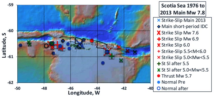
L. R. Sykes

                               activity as well as several slow-slip events described in the literature occurred in
                               LCZ on the peripheries of great asperities. I describe forerunning cumulative
                               seismic moment before one great strike-slip earthquake and how it changed with
                               time.
                                  In the past, most shorter-term precursory seismic activity was identified only
                               after the occurrence of large earthquakes. Typically, it has been difficult to dis-
                               tinguish it from other seismic events that happen during the long periods of
                               stress buildup to large earthquakes.
                                  Mogi [2] described rupture in the lab of two quite different substances: ho-
                               mogeneous pine resin and three inhomogeneous rocks. The rupture of pine re-
                               sin at high stress was not preceded by small forerunning seismic events whereas
                               failures of those rocks were. The presence of inhomogeneities seems to be essen-
                               tial, at least in principle, to the occurrences of forerunning, precursory and af-
                               tershock activities not only in the lab but also at larger scales at plate boundaries.
                                  More study of the distribution of strong and weak regions along and near
                               major faults is needed not only to understand the physics of earthquakes but also
                               whether long-term earthquake prediction is either possible or unlikely for spe-
                               cific faults. Strong regions that are more difficult to break are called asperities in
                               the rock mechanics and seismological literatures. I use the terms asperities and
                               plate coupling extensively. Some parts of plate boundaries remain locked, i.e.,
                               well-coupled during stress accumulation; others are sites of poorer coupling,
                               moderate-size shocks, slow earthquakes, and fault creep. Some information about
                               the physical and geological factors that govern strong and weak asperities is ex-
                               amined here briefly.
                                  Others have analyzed the detailed distribution of large displacement (high
                               slip) over the main rupture zones for many of the mainshocks examined here.
                               They used seismic observations, data from the Geodetic Positioning System
                               (GPS) and observations of surface faulting. They found that areas of high dis-
                               placements were typically smaller than the sizes of aftershock zones.
                                  A main contribution here is to map the distributions of forerunning strike-slip
                               and intraplate earthquakes and to compare them with areas of high slip as com-
                               puted by others. Most previous work has focused on individual large earth-
                               quakes and not on what can be ascertained by examining many of them world-
                               wide. Relatively little attention has been paid to either the depths of forerunning
                               decadal activity or if locations change with time.
                                  Most very large earthquakes have occurred where plate coupling is high as
                               reported in the literature. Rupture zones of great earthquakes are often bordered
                               by zones of poorer plate coupling either along strike, downdip, updip or adjacent
                               to them along nearby faults. Some of the clearest examples of forerunning activ-
                               ity to large earthquakes are sought with the hope that better knowledge gained
                               from them will permit less well-defined cases to be interpreted better.
                                  How can great asperities be identified beforehand if they do not rupture until
                               the time of a great or giant shock? I find that earthquakes of moderate to major
                               size in the decades before very large events mostly occurred near the peripheries

DOI: 10.4236/ijg.2021.129044                        786                           International Journal of Geosciences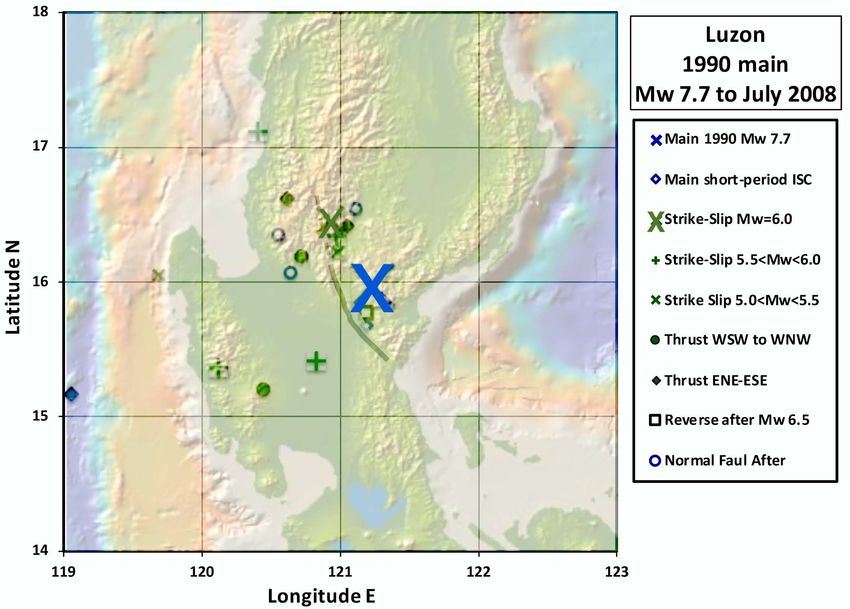
L. R. Sykes

                               of great asperities that later broke in great mainshocks. Shocks of moderate to
                               major size can be used to map great asperities that are mostly quiet seismically
                               before they rupture in mainshocks up to decades later. Precursory seismic and
                               geodetic changes to great events should be sought on the peripheries of great as-
                               perities and not just along great faults themselves. Some claims that large earth-
                               quakes do not have precursors result from sampling only the faults that ruptured
                               in great events. Many were looking in the wrong places.
                                  This study builds upon previous work on great earthquakes, seismic gaps, fo-
                               rerunning activity and aftershocks by Fedotov [3], Mogi [4] [5], Sykes [6], Kel-
                               leher et al. [7] and others. Seismic gaps are segments of active plate boundaries
                               that have not been the sites of large earthquakes for decades to hundreds of
                               years. Those early studies typically used the extent of aftershock zones to map
                               the rupture zones of great earthquakes. They did not have access to either GPS
                               data, very long-period centroid locations of earthquakes, information on slow-slip
                               events or finite-fault slip computations of sub-areas of high slip. Forerunning
                               earthquakes of magnitudes as small as 5.0 are used in this paper. This permits
                               many smaller events to be used to map the approximate rupture zones of many
                               coming individual great mainshocks up to decades ahead of time.
                                 One of the major findings of this paper is that the spatial distribution of fore-
                               running earthquakes differs between oceanic and continental transform faults.
                               Forerunning activity was found to be very concentrated for oceanic transforms
                               and more widespread near continental transform faults. Little to no forerunning
                               activity on a time scale of a few decades was found for the intraplate earthquakes
                               studied. This is attributed to the need to include much longer periods of analysis
                               for intraplate areas where strain buildup likely is slower than for most active
                               plate boundaries.
                                 The distributions of forerunning activity, great and moderate-size asperities,
                               differences in plate coupling, and velocity strengthening and weakening mate-
                               rials can be considered as the building blocks or the architecture of seismic ac-
                               tivity along and near strike-slip faults and subduction zones. Some may be useful
                               for more detailed predictions or forecasts of large earthquakes.

                               2. Methods
                               Giant earthquakes are defined as those of seismic magnitude 8.5 or larger on the
                               moment magnitude scale, Mw, and great shocks as those of 7.7 ≤ Mw < 8.5. Mw
                               and its corollary seismic moment, Mo, are needed to quantify the very large di-
                               mensions and magnitudes of great and giant earthquakes. Seismic moment, Mo
                               in N-m, is related to Mw by
                                                             logMo = 1.5 Mw + 9.1                                (1)
                                 I define major shocks as those of 7.0 ≤ Mw < 7.7 and moderate-size earth-
                               quakes as with 5.0 ≤ Mw < 7.0. I examine earthquakes of Mw 5.0 and greater and
                               focus on shallow events on or near plate boundaries of the transform-fault type
                               as well as on earthquakes within lithospheric plates, so-called intraplate shocks.

DOI: 10.4236/ijg.2021.129044                        787                         International Journal of Geosciences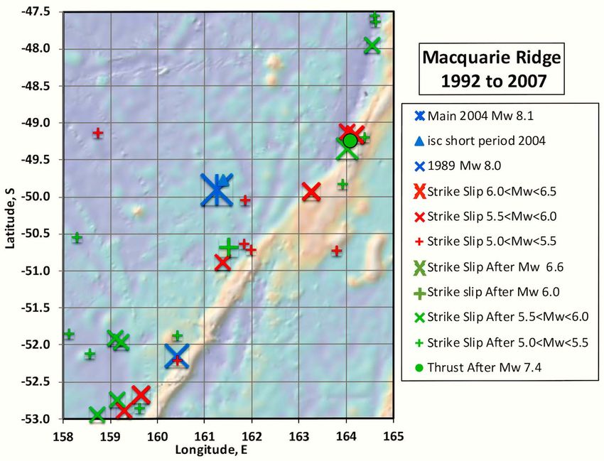
L. R. Sykes

                                 Sykes [1] found that 69% of shallow earthquakes worldwide of Mw ≥ 7.7 were
                               located at subduction zones, 7% involved normal-faulting and most of the rest
                               occurred with strike-slip mechanisms either along transform plate boundaries or
                               within lithospheric plates.
                                 Locations, magnitudes and seismic moments of earthquakes shallower than 70
                               km along transform faults and within lithospheric plates were obtained from the
                               Global Centroid Moment Tensor (GCMT) catalog since it started in 1976 [8] [9].
                               The centroids of slip are plotted and emphasized here rather than points where
                               slip initiated. GCMT locations and their magnitude, Mw, utilize some of the
                               largest and longest-period seismic waves. The types of GCMT focal mechanisms
                               in the figures are distinguished in terms of thrust, normal, strike-slip and reverse
                               faulting. GCMT solutions have improved over time and have been extended to
                               events as small as Mw 5.0 [10].
                                 Older locations and magnitudes are from the Bulletin of the International
                               Seismological Centre and the 1992 catalog of Pacheco and Sykes [11]. The com-
                               puter program GeoMapApp [12] was used for bathymetry and topography.
                               Calculations of slip distributions in individual large earthquakes are taken from
                               the literature as identified in the captions.
                                 Uncertainties exist in the relative and absolute locations of the centroids of the
                               shocks analyzed in this paper as well as in computations by others of areas of
                               high slip in mainshocks. For the of areas of high slip in mainshocks, I used re-
                               sults that included whenever possible local and distant seismic data, geodetic
                               observations, and mapping of rupture at the earth’s surface. Relative locations
                               likely can be improved by applying double-difference methods.
                                 I added zones of computed high slip for large earthquakes. Those computa-
                               tions, often called finite-fault rupture models, map variations in slip during large
                               mainshocks. In the figures I plot two contours of high slip from sources in the
                               literature along with forerunning activity and centroids of mainshocks. The point
                               where rupture initiated, the epicenter as determined from short-period data, is
                               plotted as well for mainshocks.
                                 After the start of the GCMT database in 1976, I needed to have many years of
                               forerunning activity for an adequate analysis of a subsequent large shocks. Hence,
                               the mainshocks studied here were limited to the period 1989 to August 2020
                               (Table 1). Results for three older great earthquakes are included as well.

                               3. Results
                               3.1. Asperities, Earthquakes and Low-Coupling Segments
                               The greatest earthquakes along strike-slip faults, which are taken here to break
                               the largest asperities, typically occur at depths of a few to 15 km but sometimes
                               as great as 25 km. Transform plate boundaries at depths greater than about 15 to
                               25 km move without earthquakes. I show that great asperities are largely or to-
                               tally locked during periods of slow stress buildup to mainshocks whereas smaller
                               asperities, mostly on their peripheries, rupture in forerunning earthquakes of

DOI: 10.4236/ijg.2021.129044                         788                         International Journal of Geosciences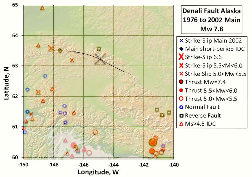
L. R. Sykes

                                     moderate to large size. Slow-slip seismic events occur in low-coupling zones be-
                                     tween great asperities as well as updip and downdip of them. The mainshocks
                                     examined within plates, however, were preceded by few, if any, forerunning
                                     shocks going back to 1976. Extending the record well back in time may be
                                     needed to map any patterns of forerunning events for intraplate regions since
                                     they are characterized by show stress accumulations and very long-repeat times.
                                        Scholz ([15], p. 73) interprets earth materials along much of the shallowest
                                     part of plate boundaries at depths of a few kilometers as in the velocity-streng-
                                     thening regime of rock mechanics Rocks below those where great earthquakes
                                     and great asperities are found are taken to be in the velocity-weakening re-
                                     gime.

Table 1. Earthquakes studied.

                                               Latitude   Longitude    Depth      Magnitude     Figure     Long-Term Slip
          Earthquake               Date
                                                GCMT       GCMT         km          Mw         Number        Rate, mm/a

      Calilfornia, southern      1857 Jan 9      35.7      −120.3        14          7.9      33 and 34          33

      California, northern      1906 Apr 18      38.0      −123.0        12          7.8       1 and 32          28

           Guatemala            1976 Feb 4       15.1      −89.78        16          7.5      30 and 31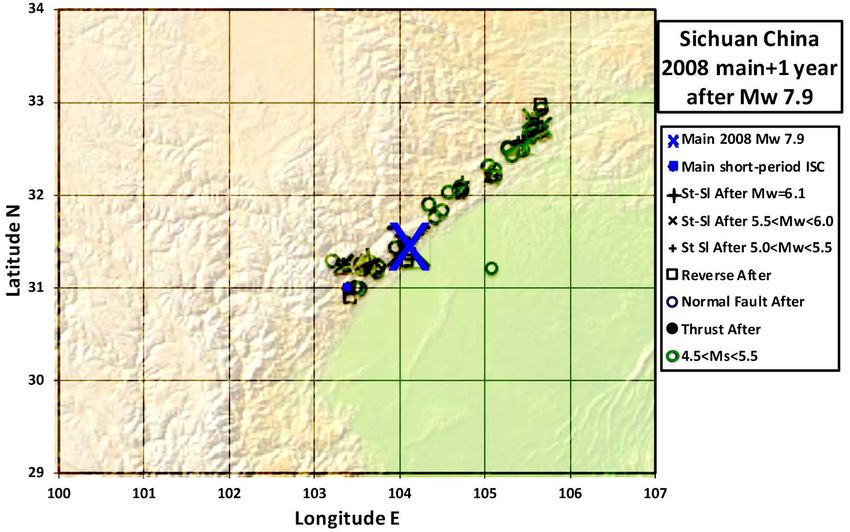
L. R. Sykes

                               3.2. A Model of Slip and Asperities—The San Andreas Fault,
                                    California
                               Figure 1 illustrates some of the patterns of forerunning activity before several
                               large strike-slip earthquakes within continents, in this case numerous prior shocks
                               in a broad area near the coming rupture zone of the great 1906 San Francisco
                               earthquake. Surrounding activity was then low from 1920 until about 1954. Most
                               of the 1906 rupture zone along the San Andreas fault itself was quiet in the dec-
                               ades prior to 1906; forerunning activity occurred along other faults including
                               strike-slip faults in the San Francisco Bay area. The four nearby dots northeast of
                               San Francisco Bay denote some of the largest prior shocks. They occurred on or
                               near mapped thrust faults [16]. Plate motion in the area includes a modest
                               component of convergence in addition to strike-slip faulting. Those two types of
                               faulting are partitioned spatially.

                               Figure 1. Forerunning activity of magnitude 5 and greater (solid dots) in the greater San
                               Francisco Bay area, California from 1872 until the great 1906 earthquake (upper left).
                               Three other time windows are illustrated. Largest solids dots denote epicenters of the
                               1868, 1906 and 1989 mainshocks. Heavy solid lines show rupture zones of mainshocks
                               along San Andreas fault in 1906 and 1989 and the Hayward fault in 1868 from [16].

DOI: 10.4236/ijg.2021.129044                         790                           International Journal of Geosciences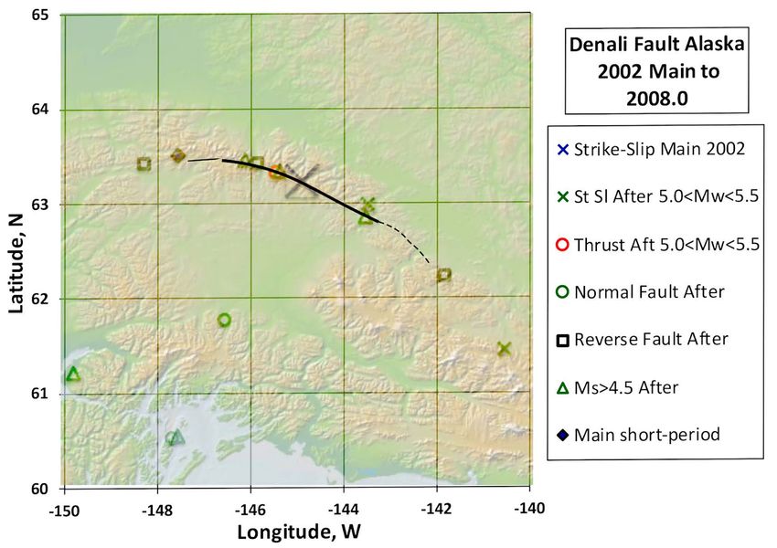
L. R. Sykes

                                 Several of the examples to follow show similar patterns of forerunning activity
                               for continental areas. I find that forerunning activity and aftershocks for trans-
                               form faults in oceanic areas typically are much more concentrated spatially than
                               those in continental areas.

                               3.3. Patterns of Forerunning Activity—Strike-Slip Faults
                               3.3.1. Pakistani Earthquake of 2013, Mw 7.7
                               Figure 2 illustrates forerunning activity from 1976 until the occurrence of the
                               southern Pakistani earthquake of 2013 in Balochistan province of Mw 7.7. Its
                               mechanism involved strike-slip displacement with a small thrust component
                               along the Hoshab fault, a part of the plate boundary that extends northeasterly
                               near the eastern end of the Makran subduction zone. The GCMT epicenter of
                               the main shock, a measure of its centroid location, is situated near the middle of
                               the areas of large horizontal slip in 2013 (solid black and dashed lines) as deter-
                               mined by [17] from geodetic data and seismic-wave modeling.
                                 Rupture in the mainshock initiated near the northeastern end of the zone of
                               largest moment release at the short-period epicenter. Rupture progressed
                               southwesterly [17]. It was followed by a smaller release of moment [17], proba-
                               bly in the smaller zone of slip along the northeastern end of surface rupture.
                                 Most of the forerunning activity and many aftershocks of Mw > 5.0 were si-
                               tuated to the northeast of the two main zones of displacements in the main-
                               shock, i.e., well off the rupture zones. Some of that activity may have occurred
                               on sub-parallel faults to the one that broke in 2013. Most of the rupture zone can
                               be considered as a great asperity along its southeastern end and a smaller asperi-
                               ty along its northeastern end. Each remained nearly quiet seismically for decades
                               ahead of time until they ruptured in the Mw 7.7 event. This pattern is like that
                               prior to the 1906 San Francisco event (Figure 1) and other transform faults within
                               continental areas as well as along many subduction zones [1].
                                 Barnhart et al. [18] mapped surface rupture of the 2013 mainshock using
                               Landsat 8 satellite data with a spacing of 15 m resolution. They found that slip
                               was not parallel to the direction of relative motion between the Arabian and Eu-
                               rasian plates and hence, that compressional deformation must occur at other
                               times either along either the Hoshab fault itself or in a broader surrounding
                               zone.
                                 In summary, most forerunning activity and aftershocks occurred at a distance
                               from the two main rupture zones of the 2013 mainshock. The two rupture zones
                               can be regarded as major asperities that accumulated stress in the preceding
                               decades and released it suddenly in 2013. Searches for shorter-term foreshock
                               activity to the 2013 and other strike-slip mainshocks within continents should
                               include broad areas of forerunning activity like that in Figure 2 and not just sin-
                               gle zones of surface rupture in past great earthquakes. Concentrating just on the
                               main fault itself may well miss prior activities that may be useful for interme-
                               diate and short-term predictions.

DOI: 10.4236/ijg.2021.129044                        791                         International Journal of Geosciences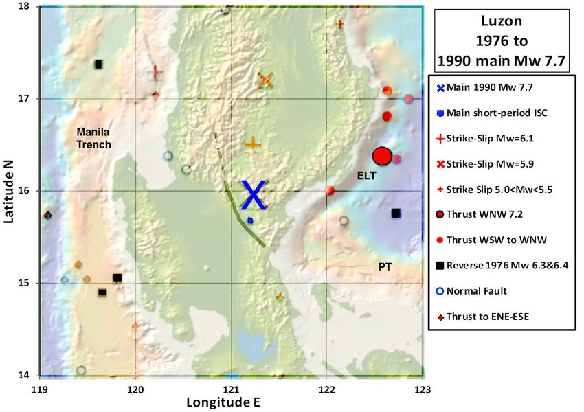
L. R. Sykes

        Figure 2. Locations and mechanisms of earthquakes of Mw ≥ 5.0 from 1976 through the Pakistani mainshock (large blue
        circle) in 2013 of Mw 7.7. Heavy solid and dashed lines enclose regions of computed slip greater than 5 and 2 m in the
        mainshock from [17].

        Figure 3. Forerunning activity from 1976 until two mainshocks of 2018 and 2020 of Mw 7.5 and 7.7. The Cayman
        spreading center is located near the normal faulting events in the center of the figure at 81.8˚W. The deep Cayman trough
        is about 100 km wide and is shown in purple. Sea floor to the north and south of the Cayman trough is shallower than that
        in normal oceans. Solid and dotted black lines indicate computed slip greater than 6 and 4 m in the 2020 mainshock from
        [19].

                                        3.3.2. Earthquakes along Cayman trough of 2018 and 2020, Mw 7.5,
                                               Mw 7.7
                                        Two large strike-slip earthquakes ruptured transform faults on the two sides of
                                        the Cayman spreading center (Figure 3) in 2018 (Mw 7.5) and 2020 (Mw 7.7).
                                        The well-defined spreading center, which is about 100 km in length from north

DOI: 10.4236/ijg.2021.129044                                  792                           International Journal of Geosciences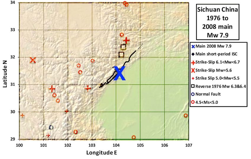
L. R. Sykes

                               to south, spreads at about 75% of the long-term rate of relative movement of
                               about 21 mm/yr. between the North American and Caribbean plates. The Swann
                               transform fault to the west of the spreading center, the site of the 2018 main-
                               shock, takes up nearly the full plate motion. Each of the two transform faults at
                               the eastern ends of the Cayman spreading center are active. The 2020 mainshock
                               broke the northern most active of the two, the Oriente transform, which passes
                               off the coast of southeastern Cuba.
                                  Rupture in the 2020 mainshock proceeded westward toward the Cayman spread-
                               ing center from its short-period epicenter. No forerunning activity occurred for
                               about 100 km on either side of the centroid location of the 2020 mainshock and
                               along that part of the Oriente transform fault for which [19] computed slip was
                               greater than 6 m (Figure 3). That area is also notable for an absence of reported
                               earthquakes as small as magnitude, mb, 4.5 since 1920. Clearly, that absence of
                               forerunning activity defines a great asperity along that transform. Some slip as
                               great as 4 m farther west along the Oriente transform closer to the Cayman
                               spreading center was reported [19]. While it experienced five forerunning
                               shocks in Figure 3, whether the area of 4 m slip coincided with them is uncer-
                               tain. A reanalysis of the locations of those earthquakes is needed.
                                  Abundant forerunning activity in Figure 3 also took place at distances great
                               than 100 km from the centroid of the 2018 mainshock along the Swann trans-
                               form. Some forerunning activity to the east, however, occurred close to the cen-
                               troid. Again, those small forerunners need to be relocated. The 2018 mainshock
                               ruptured westward from that area into the region of no forerunning activity in
                               Figure 3. The latter was the site of no shocks of mb 4.5 or greater since 1920. No
                               estimate of detail slip is known to the author for the 2018 mainshock. Hence, it
                               is difficult to estimate the distribution of large asperities for the relatively small
                               shock of Mw 7.5.
                                  In summary, forerunning activity did not occur within 100 km of the centroid
                               of the 2020 mainshock and little within 100 km of the 2018 event. The region of
                               computed slip greater than 6 m in the 2020 main event was not the site of fore-
                               running shocks; it is identified as a great asperity. The seismic activity along the
                               two oceanic transforms occurs along two narrow zones, a very different pattern
                               than that seen in Figure 1 and Figure 2 for continental transform fault zones.
                               Forerunning activity did not occur perpendicular to the zone of high slip in the
                               2020 mainshock.

                               3.3.3. Macquarie Ridge Earthquake of 1989, Mw 8.0
                               The Macquarie Ridge, which extends from southern New Zealand to a plate
                               triple junction north of Antarctica, has been the site of many great strike-slip
                               and thrust earthquakes, including the strike-slip mainshock of Mw 8.0 of 1989.
                               Eighty percent of the slip in that mainshock occurred along the plate boundary
                               [20] close the short-period epicenter (Figure 4), more concentrated than reported
                               for many other great strike-slip events. The centroid of the 1989 mainshock (GCMT)
                               was situated near the regions of computed large slip. Forerunning events and after-
                               shocks largely occurred outside those slip zones.

DOI: 10.4236/ijg.2021.129044                        793                           International Journal of Geosciences
L. R. Sykes
Figure 4. Forerunning and aftershock activity for the Macquarie Ridge mainshock of 1989 of Mw 8.0.
Largest blue symbol in center denotes centroidal location of mainshock. Solid black lines indicate short re-
gion in which 80% of its computed displacement occurred after [20].
In summary, the zone of largest computed displacement in the 1989 main-
shock was nearly quiescent for forerunning and aftershock activity. Thus, it ap-
pears to have been a major asperity that built up stress for many decades before
it ruptured in 1989.
3.3.4. Intra-Plate Earthquake West of Macquarie Ridge in 2004, Mw 8.1
The strike-slip mainshock of 2004 of Mw 8.1 occurred about 75 to 125 km to the
northwest of the plate boundary along the Macquarie Ridge. Neither of its two
fault planes is nearly parallel to the strike of the Macquarie Ridge, indicating it
likely was an intraplate earthquake shock. Hayes et al. [21] comment on the
presence of activity to the northwest of the plate boundary, as in Figure 4 and
Figure 5, and relate that deformation to the slow growth of a new plate or block
as the ratio of strike-slip to reverse motion along that part of the plate boundary
changed over the past few million years. Similar activity, however, does not ex-
tend southeast of main plate boundary.
Nearby forerunning activity to the 2004 mainshock in Figure 3 and Figure 4
took place closer to the plate boundary than to its centroid. It may have had little
if any relationship to the coming 2004 mainshock. To my knowledge, no one has
published a detailed slip distribution for the 2004 event. I consider the mapped
distribution of high-frequency radiation by [22] a relatively poor representation
of detailed slip.
In summary, the 2004 mainshock occurred well to the northwest of the plate
boundary in an area of little forerunning activity. It likely was an oceanic intrap-
late event. A detailed mapping of slip is needed.
DOI: 10.4236/ijg.2021.129044 794 International Journal of GeosciencesL. R. Sykes
Figure 5. Forerunning and aftershock activity to the Macquarie Ridge mainshock of 2004 of
Mw 8.1. Largest blue symbol denotes centroid location of 2004 mainshock.
3.3.5. South Scotia Sea Earthquake of 2013, Mw 7.8
A great earthquake in 2013 of Mw 7.8 occurred along a transform fault that
bounds the southern margin of the Scotia Sea just to the north of the South
Orkney Islands in the southernmost Atlantic Ocean. Long-term plate motion is
slow, about 6.4 mm/a, along that boundary between the Scotia and Antarctic
plates [23]. It occurred well to the west of the southern end of the Scotia subduc-
tion zone (not shown).
Rupture started at the short-period epicenter (Figure 6) and proceded easter-
ly. Slip in the mainshock as computed by Ye et al. [23] was larger than 5 m in the
two zones enclosed by solid black lines. They also computed slip in the earlier
2003 shock of Mw 7.6 to its east, which broke a small part of the eastern region
that ruptured more than 5 m in 2013. Since the centroid of the 2013 mainshock
is located west of much of the slip computed by [23], at least one of those esti-
mates is problematic.
The centroid calculations for the 2013 and 2003 mainshocks indicate mainly
strike-slip motion with a normal-faulting component on east-west striking faults
that dip 44˚ and 36˚ south under the region of shallower ocean water in Figure 6.
All of the forerunning strike-slip activity prior to the 2013 mainshock was lo-
cated well to either the east or west of its centroid and outside the computed
zones of high slip. A single earthquake of Mw 5.7 with a thrust mechism oc-
curred in 1991 between the two zones of highest slip. Two of the largest forerun-
ning events, those of Mw 6.9 and 6.0, occurred one and four days before the
2013 mainshock. The north-south extent of seismic activity is somewhat broader
than that for the two Cayman transforms in Figure 3.
DOI: 10.4236/ijg.2021.129044 795 International Journal of GeosciencesL. R. Sykes
Figure 6. Forerunning activity from 1976 until mainshock in 2013 of Mw 7.8 (large blue X) and aftershocks
until 2021.1. Computed slips in 2013 larger than 5.0 and 2.5 m are shown as solid and dashed black lines
from [23]; slip zones between 2.5 and 5.0 m in the earlier 2003 event of Mw 7.6 are indicated by the two
small gray areas surrounded by dots.
In summary, forerunning strike-slip activity to the 2013 mainshock occurred
outside the regions of high computed slip and within what are interpreted as ei-
ther one or two major asperities. Seismic moment release increased in the 10
years before the mainshock compared to that from 1976 to 2003. Foreshocks
occurred within four days of the 2013 event. The 2013 shock took place along a
plate boundary with low long-term slip rate.
3.3.6. Earthquake in Central Alaska of 2002, Mw 7.8
The 2002 mainshock of Mw 7.8 ruptured the surface of the Denali and Tot-
schunda faults in central Alaska for about 340 km mainly with strike-slip dis-
placement. The Denali fault has largest long-term slip rate of faults within con-
tinenal Alaska with the exception of the Fairweather fault in southeast Alaska.
The 2002 mainshock was preceded ten days earlier by a foreshock of Mw 6.6
(large red X in Figure 7) just to the western end of rupture in the the mainshock
[24]. Rupture started at the small black diamond in Figure 7 and proceeded eas-
terly and then southeasterly. It subsequently jumped to the Totschunda fault,
where slip was smaller. Rupture did not extend farther southeastward along the
continuation of the Denali fault.
Eberhart-Phillips et al. [24] state that the long-term slip rate for that part of
the Denali fault that broke in 2002 was about 10 mm/a, about 1/7 of the rate for
the relative motion of the Pacific and the North American plates. The long-term
rate for the part of the Denali fault to the southeast that did not rupture in 2002
is about 2 to 3 mm/a; that for the Totschunda fault, about 5 mm/yr.
Rupture in the mainshock was mainly strike slip but with a small compres-
sional component. Most aftershocks occurred at depths less than 10 km, an in-
dication of shallow slip in 2002 [24]. Except for the foreshock, only one small
forerunning earthquake occurred within 150 km of the rupture zone of the
mainshock. The same result can be seen for events as small as Ms 4.5 in Figure 7
DOI: 10.4236/ijg.2021.129044 796 International Journal of GeosciencesL. R. Sykes
and Figure 8. A few aftershocks took place on or close to the rupture zone (Fig-
ure 8). Some aftershocks smaller than magnitude 5.0 along and near the rupture
zone are shown in [24].
Figure 7. Activity of Mw > 5.0 from 1976 until the mainshock of 2002 (large black X).
Calculated co-seismic slip larger than 4 m (solid black line) along the Denali fault and 2 to 4
m along its western end and the Totschunda fault (dashed lines) are from [24]. Triangles are
events of Ms > 4.5 from the International Seismological Centre plotted at their short-period
epicentral locations.
Figure 8. Aftershocks from Alaska mainshock of 2002 through 2007. Symbols same as previous
figure.
DOI: 10.4236/ijg.2021.129044 797 International Journal of GeosciencesL. R. Sykes
In summary, the coming rupture zone of the mainshock was surrounded by a
large region with very low forerunning activity. It can be interpreted as a major
asperity. The few forerunners indicate, however, that they could not have been
used ahead of time to map the size of the coming mainshock with much accura-
cy.
3.3.7. Earthquake of 2013 off the Coast of Craig, Southeast Alaska,
Mw 7.5
The strike-slip earthquake of 2013, Mw 7.5, occurred off the coast of southeast
Alaska along the Queen Charlotte-Fairweather fault system, which forms the
boundary between the Pacific and North American plates. The mainshock was
situated at the boundary between continental and oceanic lithosphere. It is one
of the smallest earthquakes along a transform-fault that is examined here. A
small number of forerunning events of magnitude 4.5 and greater took place
south of the centroid of the mainshock. All but one of them occurred outside of
the zones of computed displacements larger than 2 m. The location of the cen-
troid to the north of those computed contours suggests rupture extended some-
what farther to the northwest.
In summary, the 2013 mainshock occurred along a transform plate boundary
off the coast of southeast Alaska. The region of high computed slip and the cen-
troid location were largerly quiet for forerlunning events; they define a major
asperity that broke in the mainshock of 2013. Forerunning and aftershock activ-
ity took place in a narrow zone along strike, similar to the patterns after the two
mainshocks along the transform faults bordering the Cayman Trough in Figure
3.
Figure 9. Forerunning activity and aftershocks of the Craig, southeastern Alaska mainshock
(large black X) of 2013, Mw 7.5. Solid line indicates computed displacement greater than 4 m;
dashed line, 2 to 4 m from [25].
DOI: 10.4236/ijg.2021.129044 798 International Journal of GeosciencesL. R. Sykes
3.3.8. Strike-Slip Earthquake of 2017 along Komandorsky (Commander)
Islands, Mw 7.8
The great earthquake of 2017 in the westernmost Aleutian Islands involved stri-
ke-slip motion between the North American and Pacific plates. Plate motion
changes from nearly perpendicular convergence south of mainland Alaska to
very oblique convergence, i.e. nearly along-strike motion, in the westernmost
Aleutians. Plate motion then changes abruptly from near total strike-slip motion
near the 2017 rupture zone to underthrusting farther west beneath Kamchatka.
Using GPS data from the Komandorsky Islands and Kamchatka, Kogan et al.
[26] concluded that plate motion in the westernmost Aleutians is partitioned
into strike-slip motion along a Bering fracture zone (transform fault) to the
north of the Komandorsky Islands and along-strike motion on a shallow-dipping
interface to their south. They found that model fit the GPS data best with two
zones of major long-term plate motion that are separated and partitioned by a
narrow Komandorsky block or sliver. About 2/3 of the total plate motion occurs
along the Bering fault between the North American plate to its north and the
Komandorsky sliver to its south (computed plate motion in the western Aleu-
tians is nearly the same if a distinct Bering plate is analyzed instead of using the
North American plate).
Lay et al. [27] computed slip as a function of length along strike for the 2017
mainshock. Slip extended a great distance, nearly 400 km with smaller slip in a
zone about 100 km along strike near the centroid of the mainshock (Figure 10).
Rupture progressed mainly to the southeast from the short-period epicenter but
with a minor region of slip to its northwest [27]. The locations of forerunning
activity are difficult to correlate with the well-separated patches of computed
high slip. Forerunning activity occurred southeast of the region of highest slip in
Figure 10 including a thrust event of Mw 6.2 just off the southeastern corner of
Figure 10. A forerunning event 45 days before the mainshock of Mw 6.7 took
place about 40 km to the northeast of the rupture zone. Other forerunning activ-
ity occurred, however, near the three zones of computed slip of 1.7 to 3.7 m and
in the broad zone near the centroid. Foreshocks of magnitude larger than 4 oc-
curred within 12 hours of the mainshock near its short-period hypocenter [27].
The 2017 mainshock took place in what had long been regarded as a major
seismic gap that ruptured in great shocks in 1849 and 1958 somewhere in the
Komandorsky Islands [6]. The 2017 event may have broken in 1929 in an earth-
quake of Mw 7.8 [11] but its depth and mechanism are uncertain. The subduc-
tion zone to the east of the 2017 rupture broke in the giant Rat Island earthquake
of Mw 8.7 between 170˚ and 180˚ E [6] [11]. Since displacement in 2017 was
largely strike-slip, it is not surprising that it produced only a small tsunami.
In summary, the 2017 mainshock broke a known long-standing seismic gap in
the westernmost Aleutian Islands. Computed slip in 2017 was complex along
strike. Several of the larger forerunning shocks occurred outside of the coming
rupture zone. Other forerunning activity took place, however, near the three
zones than experienced moderate slip of 1.7 to 3.7 m.
DOI: 10.4236/ijg.2021.129044 799 International Journal of GeosciencesL. R. Sykes
Figure 10. Forerunning activity (in red) from 1997 until the mainshock of 2017, Mw 7.8
(large blue X), and aftershocks through 2020. Computed slips larger than 3.7 and 1.7 m are
shown as thick and thinner solid lines from [27].
3.3.9. Kaikoura New Zealand Earthquake of 2016, Mw 7.8
The great Kaikoura earthquake on the South Island of New Zealand in 2016
(Figure 11) was unusual in that it ruptured many faults at the surface and sever-
al offshore [28]. They form part of the boundary between the Pacific and Aus-
tralian plates. The GCMT mechanism of the main shock involved strike-slip
motion with a significant component of thrusting. Forerunning activity in Fig-
ures 11 and 12 also involved strike-slip and thrust mechanisms. Rupture during
the mainshock started at its southwestern end at the short-period hypocenter
and progressed northeasterly. The largest pre-event at the southwestern corner
of Figure 11 near Christchurch of Mw 7.0 was far enough away from the rupture
zone of the 2016 mainshock that it likely should not be regarded as precursory to
it.
Figure 11 indicates faults that ruptured at the surface as well as regions of
significant uplift and subsidence as determined from GPS and tide-gauge data.
Forerunning strike-slip activity in Figure 12, an enlarged view, was concen-
trated well outside the centroid of the mainshock as well as outside the region
of the highest measured uplift (Figure 11). A large region centered near the
centroid is inferred to be a great asperity that was largely devoid of forerunning
activity.
Four forerunning thrust mechanisms were concentrated south of the centroid
just offshore near the region that experienced uplift between 2.5 and 5.0. m in
Figure 11. [28] [29] [30] and others deduce that thrusting faulting occurred on
and offshore and was a significant contribution to the total moment release and
to the generation of a sizable tsunami. [31] attributes the complex distribution of
DOI: 10.4236/ijg.2021.129044 800 International Journal of GeosciencesL. R. Sykes
Figure 11. Forerunning activity from 1976 until the mainshock of 2018, Mw 7.8 (large blue X). Faults that
ruptured during mainshock are shown as black lines from [28]. Vertical uplift larger than 5.0 and 2.5 m is shown
as solid and enclosed dashed lines. Downward vertical motion larger than 2.5 m is depicted as thin dotted lines
from [29].
Figure 12. Enlarged view of forerunning activity from 1976 until New Zeal.and mainshock of 2018, Mw 7.8 (large
blue-black X). Aftershocks are included.
DOI: 10.4236/ijg.2021.129044 801 International Journal of GeosciencesL. R. Sykes
rupture and the number of faults that broke the surface to locking of the me-
gathrust below. The large size of the region that nearly lacked forerunning activ-
ity is in accord with that hypothesis.
Forerunning strike-slip activity to the northeast of the centroid took place on
or close to the Clarence and Atwatere faults. They did not experience surface
faulting during the mainshock [28] [29]. Cumulative seismic moment is shown
for that area in Figure 13. It is domated by two shocks in 2013 of Mw 6.5. Af-
terhocks in that area, however, contributed little to the total forerunning seismic
moment release. The increase in cumulative moment in 2013 could be consi-
dered to be an intermediate-term precursor to the 2018 mainshock. The region
of forerunning strike-slip activity to the west of the centroid, however did not
exhibit a significant increase in moment release with time.
In summary, the 2018 mainshock involved displacements on a number of
strike-slip and thrust faults. Most forerunning activity occurred outside the re-
gion of highest computed slip in the mainshock and well away from its centroid.
This suggests that the large size of that quiet region was controlled by a great as-
perity, perhaps on the downgoing plate interface at depth. Precursory activity
took place in 2013 on or near the Clarence and Atwatere faults, which did not
experience faulting at the surface during the mainshock.
Figure 13. Cumulative seismic moment as a function of time (area 41.5˚ to
42.0˚S, 173.5˚ to 175.0˚E) to north of centroid of mainshock near the Clarence
and Atwatere faults. Aftershocks are shown in blue but mainshock is not included
in moment accumulation.
DOI: 10.4236/ijg.2021.129044 802 International Journal of GeosciencesL. R. Sykes
3.3.10. Mainshock of 2000, Mw 7.8, Southern Sumatra, Indonesia
The 2000 earthquake near Enggano Island offshore of Sumatra was unusual in
that it was largely a strike-slip event below the forearc of the Sumatran subduc-
tion zone. Abercrombie [32] calculated that its moment release consisted of a
large strike-slip sub-event within the subducting Indian-Australian plate fol-
lowed by at least 35% thrust release on the plate interface. The 2000 mainshock
was located near the southeastern end of the rupture zone of the giant shock of
1833. In 2007 a giant earthquake of Mw 8.5 [1] rebroke the 1833 area just to the
northwest of the 2000 rupture zone. The thrust sub-event of 2000 ruptured sou-
theasterly away from the 1833 shock.
Most of the forerunning events in Figure 14 had thrust mechanisms. Its large
strike-slip sub-event occurred along the N 19˚E oriented nodal plane of the
GCMT solution with a length of 50 to 100 km [32]. Three small forerunning
strike-slip shocks occurred within 100 km of the centroid of the 2000 main-
shock. Whether any of them took place along the strike-slip sub-zone is unclear.
Several aftershocks with strike-slip mechanisms took place to the southeast of
the centroid of the mainshock (Figure 15) but most mechanisms of after events
involved thrust faulting.
Figure 14. Forerunning activity from 1976 until 2000 south Sumatran, Indonesian mainshock of Mw 7.8 (large
blue-black X).
DOI: 10.4236/ijg.2021.129044 803 International Journal of GeosciencesL. R. Sykes
Figure 15. After activity from 2000 southern Sumatra, Indonesian mainshock of Mw 7.8 (large blue-black X)
until July 2002.
In summary, the 2000 mainshock was unusual in releasing seismic moment
mainly along a strike-slip fault of steep dip within the downgoing India-Australian
plate beneath the forearc of the Sumatran subduction zone. Few of these fore-
running shocks involved strike-slip faulting. Most forerunning events and after-
shocks involved thrust events. Hence, the size of the coming rupture zones of the
2000 mainshock could not be ascertained from the forerunning activity studied
here. The 2000 shock was small compared to the giant thrust earthquake that
broke the adjacent zone to the northwest in 2007 and the previous giant event of
1833.
3.3.11. Earthquake of 1990 in Luzon along Philippine Fault System,
Mw 7.7
The 1990 mainshock of Mw 7.7 with a strike-slip faulting mechanism ruptured a
part of the Philippine fault system in central Luzon, Philipines. The Philippine
Islands form part of the complex boundary between the large Philippine Sea and
Eurasian plates. The Philippine fault system, which is within that region, is one
the major strike-slip faults of the world, similar in many ways to the San An-
dreas in California and the Alpine fault in New Zealand [33]. In a plate tectonic
framework, the series of left-lateral faults that make up the Philippine system
DOI: 10.4236/ijg.2021.129044 804 International Journal of GeosciencesL. R. Sykes
connect the easterly subducting Manila trench to the northwest with the westerly
subducting Mindanao (Philipine) trench to its southeast and the East Luzon
trench to its east (Figure 16 and Figure 17). In that sense, the Phillipine fault
system is similar to the Alpine fault system of New Zealand that connects oppo-
sitely-dipping subducting zones to its north and south.
Surface displacement was observed along a significant part of the 1990 rupture
zone (Figure 16). Silcock and Beavan [34] estimated an average slip of 5.5 to 6.5
m along the well-mapped part of the fault and 4 to 5 m about 40 to 50 km farther
north beyond the end of mapped surface rupture. They favor a faulting depth of
at least 20 km along the central part of the rupture. Velasco et al. [35] used short
and long-period seismic data to deduce that the largest slip (10 to 15 m) oc-
curred about 25 km northwest of the short-period epicenter, beyond which slip
decreased gradually as the rupture propagated into a restraining bend. The cen-
troid of the mainshock is located about 20 km east of the surface break, probably
a systematic location error.
The 1990 rupture zone likely did not dip easterly since the fault planes of the
GCMT solution are nearly vertical. Hence, only one of the forerunning events in
Figure 16 is located within 30 km of the 1990 rupture zone; none occurred along
that zone itself. Thus, the rupture zone can be regarded as a major asperity that
Figure 16. Forerunning seismic activity between 1976 and the 1990 Luzon, Philippines mainshock (large blue X).
Mapped surface rupture shown by solid line and inferred northern extension indicated by dashed line from [34]. PT is
Philippine (Mindanao) trench; ELT, the East Luzon trench.
DOI: 10.4236/ijg.2021.129044 805 International Journal of GeosciencesL. R. Sykes
Figure 17. Seismic activity from 1990 Luzon, Philippines mainshock (large blue X) until July 2008. Faults same
as in previous figure.
was quiet at the Mw > 5.0 level for at least 13 years before it broke in 1990. Fo-
rerunning activity occurred well to its west and east along the three trenches but
I do not take them to be causally related to the coming 1990 event. Several af-
tershocks were located within 20 km of the rupture zone (Figure 17). More ac-
curate locations are needed to ascertain if those events took place either on or
east of the rupture zone.
A shock of Mw 7.6 occurred on or close to the trace of Philippine fault farther
south of the 1990 rupture zone in 1937 near 14.57˚N, 121.68˚E. The subduction
zones associated with the Manila, Philippine and East Luzon trenches have been
the sites of several known shocks of surface-wave magnitude larger than 7.0
within the area of Figure 16 since 1900. None of them, however, was larger than
Ms 7.6. How much slow slip or creep occurs along them is uncertain.
The most recent historical earthquake to break the central Luzon section of
the Philippine fault occurred in 1645 [36]. From fault trenching, Daligdig [37]
finds six or seven past events broke the 1990 zone including that of 1645. He
dated a previous event as 1190 to 1390 A.C.E. and estimated an average recur-
rence interval of 300 to 400 years.
In summary, the rupture zone of the 1990 mainshock was quiet for nearby fo-
rerunning earthquakes of Mw > 5.0 from 1976 until its occurrence. It can be re-
garded as a major asperity. Not much forerunning activity was observed, how-
ever.
DOI: 10.4236/ijg.2021.129044 806 International Journal of GeosciencesL. R. Sykes
3.4. Patterns of Forerunning Activity—The Tibetan Plateau
Two great earthquakes are described in China—the first in 2008 on the east side
of the Tibetan plateau and another within it in 2001. The long-term slip rate for
the faults on which they occurred (Table 1) is small compared to that of many
plate boundaries but larger than that for many intraplate regions.
3.4.1. Wenchuan China Earthquake of 2008, Mw 7.9
The Wenchuan mainshock of 2008, Mw 7.9, broke about 285 km of the Long-
men Shan fault zone in Sichuan Province, China. That rupture zone took place
along the boundary between the east side of the Tibetan Plateau and the western
side of the Sichuan basin [38]. It caused nearly 90,000 deaths, left millions
homeless and caused huge monetary losses [38]. Earthquake mechanisms (Fig-
ure 18 and Figure 19) indicate that slip on the fault system during the main-
shock and aftershocks consisted of segments with strike-slip and reverse dis-
placements. Similar co-seismic displacements at the surface occurred along var-
ious parts of the rupture zone [38].
Another historic earthquake like 2008 has not been identified since 2300 BCE.
Trenching after the 2008 mainshock revealed a paleoseismic event at three sites
with an age of 2300 to 3300 years BCE [39]. Wang et al. [40] estimate a long-term
slip rate for the Longmen Shan fault zone of about 4 mm/a. Thus, the 2008 rup-
ture zone is not a fast-slipping plate boundary but is better described as the
boundary between two major lithospheric blocks or subplates.
Rupture in the mainshock started at the short-period epicenter (Figure 18)
near the southwestern end of the rupture zone and broke to the northeast. Na-
kamura et al. [41] used broadband seismic waves recorded at large distances to
deduce the distribution of slip in the mainshock. They concluded that major
fault slip of dip about 33˚ occurred along a southwestern segment and about 60˚
along a northeastern zone. They also found two main asperities: one about 40
km and the other about 170 km along strike from the short-period epicenter
(near 31˚N). Using data from strong-motion stations, Zhang [42] found that
major slip, interpreted as a strong asperity, occurred 20 to 50 km northeast of
the short-period epicenter, like the location of the first asperity of [41] and the
location of the centroid of the mainshock (Figure 18).
None of the forerunners to the mainshock in Figure 18 occurred near its cen-
troid nor the zones of large slip as deduced by [41] [42]. All forerunners took
place within the Tibetan plateau at a distance from the faults that ruptured in
2008 and none within the Sichuan basin. Since the number of forerunners of Mw
≥ 5.0 was small, events of surface wave magnitude Ms ≥ 4.5 are included in Fig-
ure 18 and Figure 19. Xue et al. [44] concluded there was a background seis-
micity gap of M ≥ 5.0 earthquakes and a gap of local magnitude > 4.0 close to the
Longmen Shan fault zone and its vicinity prior to the 2008 mainshock. They also
report, “The seismic activity obviously strengthened and a doughnut-shaped
pattern of M ≥ 4.6 earthquakes was formed in the middle and southern part of
the North-South seismic zone after the 2005 Dayao, Yunnan, earthquake”. Those
DOI: 10.4236/ijg.2021.129044 807 International Journal of GeosciencesL. R. Sykes
Figure 18. Forerunning activity to Sichuan, Chinese earthquake of 2008, Mw 7.9 (large blue X). Surface ruptures in the
mainshock are from [43]. In addition to events of Mw ≥ 5.0 from the GCMT catalog, shocks of Ms ≥ 4.5 from the Bulletin
of the International Seismological Centre (ISC) are shown. The ISC symbols are short-period locations. The Tibetan pla-
teau is shown in tan; the Sichuan basin, in green.
Figure 19. Aftershocks within one year of the 2008 Sichuan mainshock of Mw 7.9. Symbols same as previous figure.
DOI: 10.4236/ijg.2021.129044 808 International Journal of GeosciencesL. R. Sykes
statements agree with the results in Figure 18. They do remark, however, “A
quiescent area with M ≥ 7.0 has been formed in the middle of the [extensive]
North-South seismic zone since 1988, and the Wenchuan earthquake occurred
just within this area”. My sense is that the 2008 rupture zone was quiet at least
since 1976 and that it did not suddenly become quiescent. Since activity of M > 7
came and went elsewhere in central and western China, it may well not have
been a long-term precursor to the 2008 mainshock since it occurred so far away.
My conclusion is that very large asperities that break in great and giant events
remain quiescent for moderate and large forerunning events for many decades
and do not suddenly become quiescent part way through their cycle of stress
buildup.
In summary, forerunning activity to the 2008 mainshock did not occur near
its zones of major slip but surrounding it at a distance within the Tibetan pla-
teau. That pattern is like the forerunning one to the 1906 California earthquake
(Figure 1). A great asperity likely was present near its long-period GCMT cen-
troid and the 2008 rupture zone. The 2008 mainshock took place along the boun-
dary between the Tibetan Plateau and the Sichuan basin, the site of a well-mapped
fault zone and a long-term seismic gap. The location of the 2008 rupture zone had
not been the site of a similar great shock for 4300 to 5300 years. Since the fault
zone has a low long-term rate of slip, it may be regarded as an intraplate earth-
quake, albeit one in a more active region than the interiors of many lithospheric
plates.
3.4.2. Great Strike-Slip Earthquake in Qinghai Province, Western China,
2001, Mw 7.8
One of the largest earthquakes along a strike-slip fault of the last 100 years oc-
curred in western China in 2001 of Mw 7.8. It is of particular importance in the
Uniteld States since it was comparable in size and rupture length to the San
Francisco earthquake of 1906. Surface rupture in 2001 extended about 426 km
(Figure 20 and Figure 21) along the Kunlun Mountain fault system [45] [46]
[47] [48]. It is one of the major fault zones along which Tibet is moving easterly
as it is being squeezed by the surrounding Indian and Eurasian plates.
Slip started at the short-period epicenter near 90.5˚E and propagated largely
unilaterally to the east. A small amount of slip occurred to its west. Xu et al. [47]
report the rupture zone was oriented N100˚ ± 10˚E on average, and slip in 2001
consisted of three main sections—a short westernmost strike-slip section, a short
transtensional segment near the start of rupture and a long eastern strike-slip
section. Most of the moment release occurred along the eastern segment. They and
others subdivide that eastern section into several parts of which several sub-zones
slipped more than 5 m. They also report a reassessment of the maximum coseis-
mic horizontal displacement of 7.6 ± 0.4 m at a site just to the east of the cen-
troid, which is consistent with independent measurements derived from inter-
ferometric synthetic aperture radar and seismology.
DOI: 10.4236/ijg.2021.129044 809 International Journal of GeosciencesL. R. Sykes
Figure 20. Forerunning activity from 1976 until the 2001 Kunlunshan mainshock of Mw 7.8 (large blue-black X). Surface
faulting during mainshock is shown as black lines from [45] [46] [47] [48].
Figure 21. Aftershock activity from the 2001 Kunlunshan mainshock, Mw 7.8 (large blue-black X) through 2009. Surface
faulting and references are the same as in the previous figure.
No forerunning shocks in Figure 20 were situated on the surface rupture,
much of which can be considered to be the site of one or more major asperities.
Seismicity recorded one year before the 2001 Kunlun earthquake by the China
Seismic Net-work DMC (CSNDMC) indicated there was almost no activity in
the rupture area of the 2001 event [48]. Several aftershocks occurred on or close
to its surface rupture. Two strike-slip forerunnng events of Mw 5.4 and 5.3 took
place in 1980 and 1989 within 50 km of the rupture zone. They need to be relo-
cated by double-difference techniques to ascertain if they were either on or off
the 2001 rupture zone. The distribution of forerunning seismicity at a distance
from the rupture zone is similar to that prior to the 1906 California and 2013
DOI: 10.4236/ijg.2021.129044 810 International Journal of GeosciencesL. R. Sykes
Pakistani earthquakes (Figure 1 and Figure 2).
Van der Woerd et al. [49] computed a mean Late Pleistocene-Holocene left-
lateral slip-rate of 11.7 ± 1.5 mm/a for the Kunlun fault and estimated a repeat
time for the 2001 rupture zone of about 800 to 1000 years. A shock in 1937 of
Mw 7.5 took place east of the 2001 rupture zone. Two events in 1973 of Mw 7.4
[11] and one in 1997 of Mw 7.5 occurred along a branch of the Kunlun fault well
to the west. The 2001 rupture zone was a seismic gap for at least the 135 years of
instrumental seismology. I am not aware of any pre-instrumental earthquakes
that were described using either historic data or paleoseismic studies.
In summary, forerunning activity after 1976 did not occur on or close to the
mapped surface rupture zone of the 2001 giant earthquake. It consisted of one or
more major asperites that were quiet before they broke in the mainshock. Could
forerunning activity have been used ahead of time to define the approximate size
of the forthcoming great earthquake? While forerunners were small in number,
the Kunlun fault system has one of the fastest, if not the fastest, long term slip
rates of faults along which Tibet is moving easterly with respect to surrounding
regions. Future work could concentrate on other parts of the Kunlun fault sys-
tem itself that have not ruptured for a long time, examining possible places
where forerunning activity either occurs or not. Gathering paleoseismic data and
searches for additional historic information are important in long-term assess-
ments. More work could be done to examine events smaller than magnitude 5 as
well as earthquakes before 1976 and to locate them using double-difference tech-
niques.
3.5. Patterns of Forerunning Activity for Intraplate Earthquakes
3.5.1. Antarctic Intraplate Earthquake Northwest of the Balleny Islands
in 1998, Mw 8.1
A great earthquake of Mw 8.1 occurred in 1998 within the oceanic part of the
Antarctic plate (Figure 22) about 300 km from the nearest plate boundary. It
took place in a remote region to the southeast of Australia, southwest of New
Zealand and north of Antarctica. It is the largest known earthquake within the
Antarctic plate. The two zones of high activity to the north and northeast of the
1998 centroid occurred along two transform faults of the Australian-Antarctic
plate boundary. No forerunning activity occurred before the mainshock, likely
because of very slow stress buildup to it and other intraplate events.
Rupture in the 1998 mainshock started at the short-period epicenter just to
the east of its centroid and propagated 276˚ west-northwesterly but along two
separated zones of the same strike [50]. Higher moment release occurred in a
first sub-event within 140 km of its initiation. It was followed by a second sub-
event between 210 and 270 km. Hjörleifsdóttir et al. [51] showed, however, that
a solution involving slip between and including those zones adequately fit both
the long and short-period seismic data. All but two of the aftershocks occurred
between 100 to 200 km of the centroid. Thus, a great asperity that broke in the
DOI: 10.4236/ijg.2021.129044 811 International Journal of GeosciencesYou can also read