Eruptions of Hawaiian Volcanoes- Past, Present, and Future - General Information Product 117 - USGS Publications ...
←
→
Page content transcription
If your browser does not render page correctly, please read the page content below
Eruptions of Hawaiian Volcanoes—
Past, Present, and Future

General Information Product 117

U.S. Department of the Interior
U.S. Geological Survey

Cascades of lava fed by fountains at vent (seen spouting on the skyline) fall more than 75 feet* to fill ‘Ālo‘i Crater during the
                                          1969–71 Mauna Ulu eruption of Kïlauea Volcano. (USGS photograph by Donald A. Swanson.)

                                          *This publication uses English units of measurement. For readers who use metric units, a conversion table is given in
                                          the back of the booklet.

Cover—Eruption of Kïlauea Volcano, as viewed at dawn on January 30,
1974. Overflows from an active lava lake spill down the flank of the volcanic
shield at Mauna Ulu, built by many such overflows since 1969. The height of
this shield was nearly 400 feet when the Mauna Ulu eruptions ended in July
1974. (USGS photograph by Robert I. Tilling.)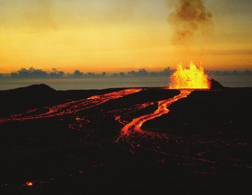
Eruptions of Hawaiian Volcanoes—
Past, Present, and Future
By Robert I. Tilling, Christina Heliker, and Donald A. Swanson

General Information Product 117
First edition, 1987
Reprinted, 1993
Second revised edition, 2010

U.S. Department of the Interior
U.S. Geological Survey
U.S. Department of the Interior
KEN SALAZAR, Secretary

U.S. Geological Survey
Marcia K. McNutt, Director

U.S. Geological Survey, Reston, Viginia: 2010
Reprinted 2014

This report and any updates to it are available online at:
http://pubs.usgs.gov/gip/117/

For product and ordering information:
World Wide Web: http://www.usgs.gov/pubprod/
Telephone: 1-888-ASK-USGS

For more information on the USGS—the Federal source for science about the Earth,
its natural and living resources, natural hazards, and the environment:
World Wide Web: http://www.usgs.gov/
Telephone: 1-888-ASK-USGS

Any use of trade, product, or firm names is for descriptive purposes only and does not imply endorsement
by the U.S. Government

Although this report is in the public domain, permission must be secured from the individual copyright
owners to reproduce any copyrighted material contained within this report.

Suggested citation:
Tilling, R.I., Heliker, C., and Swanson D.A., 2010, Eruptions of Hawaiian volcanoes—
past, present, and future: U.S. Geological Survey General Information Product 117, 63 p.

Cataloging-in-Publication data are on file with the Library of Congress (URL http://www.loc.gov/).

Contents
Preface ............................................................................................................................................................1
Introduction ....................................................................................................................................................2
Origin of the Hawaiian Islands ....................................................................................................................4
      Hawaiian Legends and Early Scientific Work ..................................................................................5
      Plate Tectonics and the Hawaiian "Hot Spot" ...................................................................................9
Hawaiian Eruptions in Recorded History .................................................................................................11
Volcano Monitoring and Research ...........................................................................................................15
      Volcano Monitoring ............................................................................................................................16
      Anatomy of an Eruption: The Inflation-Deflation Cycle ................................................................21
      Forecasting Eruptions ........................................................................................................................21
Kïlauea's Volcanic "Plumbing System" .....................................................................................................23
Hawaiian Eruptive Style: Powerful but Usually Benign .........................................................................25
      Typical Activity: "Nonexplosive" or Weakly Explosive ..................................................................25
      Infrequent Explosive Activity ............................................................................................................33
Hawaiian Volcanic Products, Landforms, and Structures ....................................................................37
      Lava Flows ...........................................................................................................................................37
      Fragmental Volcanic Products .........................................................................................................40
      Volcanic Landforms and Structures ................................................................................................42
Lō‘ihi: Hawai‘i’s Newest Volcano ..............................................................................................................48
Volcanic Hazards and Benefits .................................................................................................................50
      Volcanic Hazards ................................................................................................................................50
      Volcanic Air Pollution .........................................................................................................................54
      Volcanic Benefits ................................................................................................................................55
      Benefits of Research at the Hawaiian Volcano Observatory ......................................................56
Selected Readings .......................................................................................................................................57
Selected Viewings .......................................................................................................................................59
      Videos and (or) DVDs .........................................................................................................................59
Selected Websites .......................................................................................................................................60
Conversion of Units .....................................................................................................................................61
Glossary .........................................................................................................................................................62

                                                                                                                                                                        iii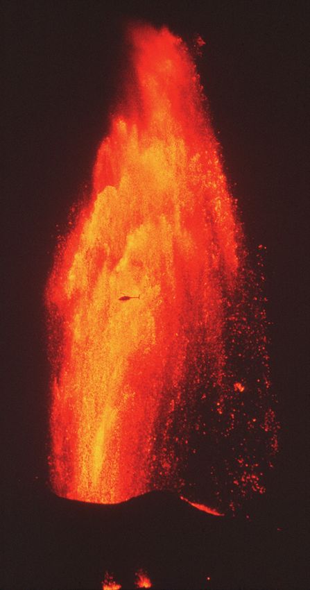
Special thanks go to Taeko Jane Takahashi and Steven R.
     Brantley, Hawaiian Volcano Observatory, for assistance
     with selection of photographic images and unwavering
     encouragement over the years.

iv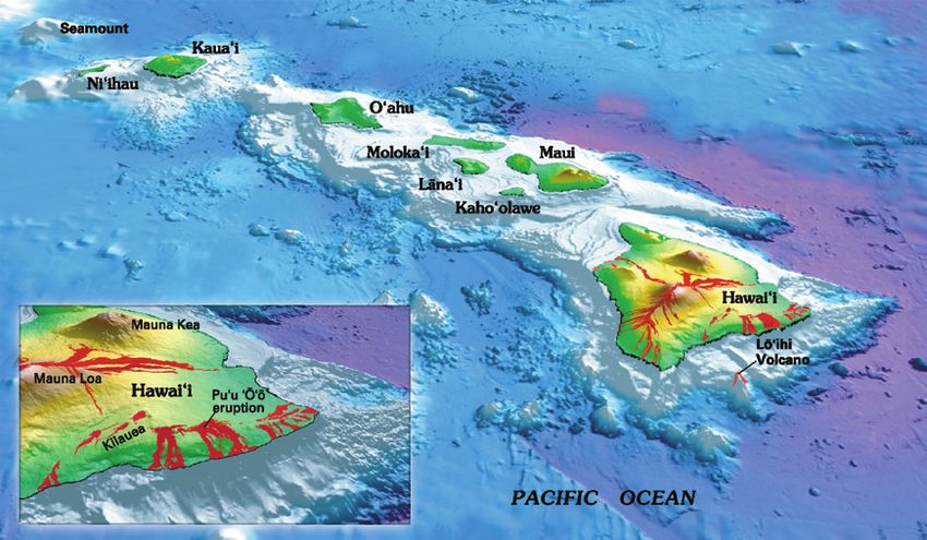
Preface
                                                                                   Viewing an erupting volcano is a memorable experience, one
                                                                              that has inspired fear, superstition, worship, curiosity, and fascina-
                                                                              tion since before the dawn of civilization. In modern times, volca-
                                                                              nic phenomena have attracted intense scientific interest, because
                                                                              they provide the key to understanding processes that have created
                                                                              and shaped more than 80 percent of the Earth's surface. The active
                                                                              Hawaiian volcanoes have received special attention worldwide
                                                                              because of their frequent spectacular eruptions, which often can
                                                                              be viewed and studied with relative ease and safety.
                                                                                   In January 1987, the Hawaiian Volcano Observatory (HVO),
                                                                              located on the rim of Kïlauea Volcano, celebrated its 75th Anni-
                                                                              versary. In honor of HVO's Diamond Jubilee, the U.S. Geologi-
                                                                              cal Survey (USGS) published Professional Paper 1350 (see list
                                                                              of Selected Readings, page 57), a comprehensive summary of
                                                                              the many studies on Hawaiian volcanism by USGS and other
                                                                              scientists through the mid-1980s. Drawing from the wealth of
                                                                              data contained in that volume, the USGS also published in 1987
                                                                              the original edition of this general-interest booklet, focusing
                                                                              on selected aspects of the eruptive history, style, and products
                                                                              of two of Hawai‘i's active volcanoes, Kïlauea and Mauna Loa.
                                                                              This revised edition of the booklet—spurred by the approaching
                                                                              Centennial of HVO in January 2012—summarizes new infor-
                                                                              mation gained since the January 1983 onset of Kïlauea’s Pu‘u
                                                                              ‘Ö‘ö-Kupaianaha eruption, which has continued essentially non-
                                                                              stop through 2010 and shows no signs of letup. It also includes
                                                                              description of Kïlauea’s summit activity within Halema‘uma‘u
                                                                              Crater, which began in mid-March 2008 and continues as of this
                                                                              writing (late 2010).
                                                                                   This general-interest booklet is a companion to the one on
                                                                              Mount St. Helens Volcano first published in 1984 and revised in
                                                                              1990 (see Selected Readings). Together, these publications illus-
                                                                              trate the contrast between the two main types of volcanoes: shield
Lava shoots 1,000 feet into the air in April 1983 during a high-fountaining
                                                                              volcanoes, such as those in Hawai‘i, which generally are nonex-
episode of the Pu‘u ‘Ö‘ö-Kupaianaha eruption of Kïlauea Volcano. (USGS        plosive; and composite volcanoes, such as Mount St. Helens in the
photograph by J.D. Griggs.)                                                   Cascade Range, which are renowned for their explosive eruptions.

                                                                                                                                                   1
Introduction                                                                    the Polynesians' secluded home. Cook named his discovery the "Sandwich
                                                                                Islands," in honor of the Earl of Sandwich, then First Lord of the British
“The loveliest fleet of islands that lies anchored in any ocean.”—Mark Twain    Admiralty. Mark Twain's fleet of islands is larger than Rhode Island and
                                                                                Connecticut combined. The Island of Hawai‘i, commonly called the "Big
                                                                                Island," covers more than twice the total area of the other islands.
     Few would quarrel with Mark Twain's vivid description of Hawai‘i,               Hawai‘i, which became our 50th state in 1959, is now home for more
written after his 4-month stay in 1866. Archeologists believe that the Hawai-   than 1.2 million people and hosts many times that number of visitors each
ian Islands were discovered and settled around the 9th century C.E. or          year. Hawai‘i's worldwide image as an idyllic tropical paradise is well
earlier by Polynesians sailing from islands, probably the Marquesas, in the     deserved. What is less well known, however, is that the islands exist only
southern tropical Pacific. Subsequently, nearly a thousand years of cultural    because of nearly continuous volcanic activity. Most of the prominent fea-
isolation passed before the first documented visit to Hawai‘i by non-Poly-      tures of the Hawaiian Islands, such as Diamond Head on O‘ahu, Haleakalä
nesians. On January 18, 1778, during his third major voyage in the Pacific,     Crater on Maui, and the huge mountains of Mauna Loa and Mauna Kea on
the famous British navigator and explorer, Captain James Cook, sighted          the Island of Hawai‘i, are volcanic.

The principal Hawaiian islands,
stretching about 400 miles from
Ni'ihau in the northwest to the Island
of Hawai'i in the southeast, are the
exposed tops of volcanoes that rise
tens of thousands of feet above the
ocean floor. Some islands are made
up of two or more volcanoes. Areas in
red on the Island of Hawai‘i indicate
lava flows erupted during the past two
centuries. Lö‘ihi Seamount, Hawai‘i’s
newest (and still submarine) volcano,
lies about 3,100 feet beneath the
sea. (Modified from image by Joel E.
Robinson, USGS, in “This Dynamic
Planet” map of Simkin and others,
2006.)

2
Since the early 19th century, frequent eruptions
have been documented at Mauna Loa and Kïlauea;
these two volcanoes on the Island of Hawai‘i are
among the most active in the world. Nearby Lö‘ihi
Seamount, off the island's south coast, is the newest
Hawaiian volcano, actively growing on the seafloor
deep beneath the ocean surface.
     Most eruptions of Mauna Loa and Kïlauea are
nonexplosive, and both volcanoes are readily acces-
sible, such that scientists generally can study them at
close range in relative safety. As a result, these are two
of the most intensely observed and best understood
volcanoes on our planet. Research on these active
volcanoes provides a basis for understanding the life
story of older, now inactive Hawaiian volcanoes and
similar volcanoes worldwide. Because of their frequent
activity and accessibility, Hawaiian volcanoes serve as
a superb natural laboratory for scientists from around
the world to study volcanic eruptions.

                                                             Shaded relief map of the southeastern part of the Island of Hawai‘i, showing the principal features and
                                                             localities of Mauna Loa, Kïlauea, and Lö‘ihi Volcanoes discussed in the text.

                                                             Lili‘uokalani Park, in the city of Hilo on the Island of Hawai'i,
                                                             typifies the tropical beauty and serenity of the Hawaiian
                                                             Islands. (USGS photograph by Taeko Jane Takahashi.)

                                                                                                                                                                       3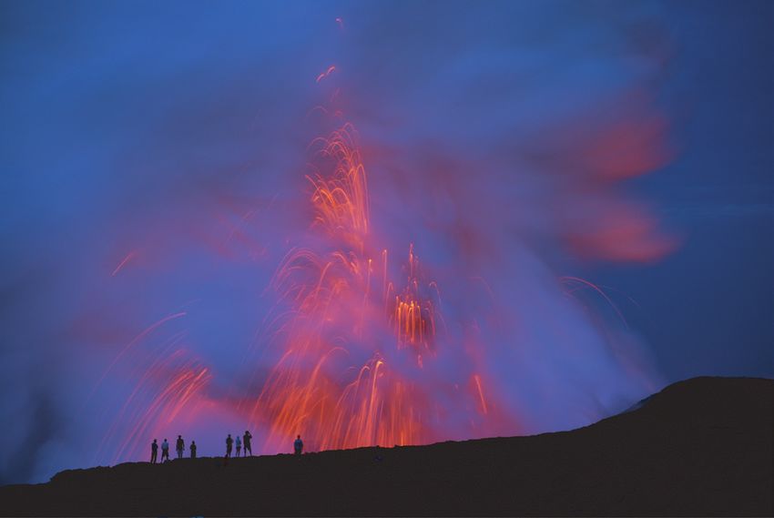
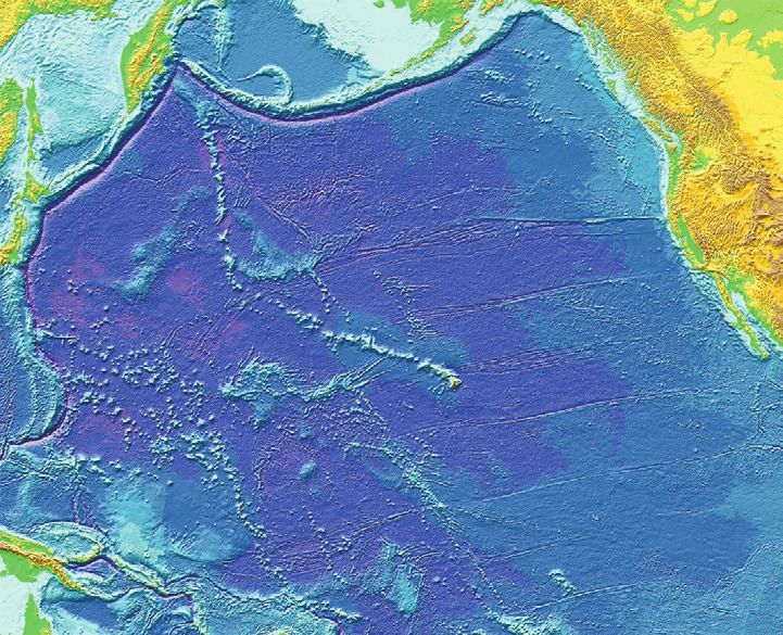
Origin of the Hawaiian Islands
     The Hawaiian Islands are the tops of gigantic
volcanic mountains formed by countless eruptions of
fluid lava* over several million years; some tower more
than 30,000 feet above the seafloor. These volcanic
peaks rising above the ocean surface represent only the
tiny, visible part of an immense submarine ridge, the
Hawaiian Ridge—Emperor Seamount Chain, composed
of more than 80 large volcanoes. This range stretches
across the Pacific Ocean floor from the Hawaiian Islands
to the Aleutian Trench. The length of the Hawaiian
Ridge segment alone, between the Island of Hawai‘i and
Midway Island to the northwest, is about 1,600 miles,
roughly the distance from Washington, D.C., to Denver,
Colorado. The amount of lava erupted to form this huge
ridge, about 186,000 cubic miles, is more than enough to
cover the State of California with a layer 1 mile thick.

*Most of the italicized terms in the text are defined and
explained as an integral part of the discussion. However,
for those terms perhaps not fully explained, a Glossary at
the back of this booklet (p. 62) provides supplementary      Map of the Pacific basin showing the location of the Hawaiian Ridge-Emperor Seamount Chain in
                                                             relation to some other features and localities mentioned in the text. (Base map from the third edition of
information or broader context.
                                                             “This Dynamic Planet” map, 2006.)

4
Hawaiian Legends and Early Scientific Work
The distinctive northwest-southeast alignment of the Hawaiian chain was
known to early explorers of the Pacific Ocean, including the Polynesians who
first settled the islands. The ancient Hawaiians were superb sailors, excellent
navigators, and keen observers of nature, including volcanic eruptions and their
effects. They noticed the varying extent of erosion from island to island, the
amount of vegetation on the slopes of the various volcanoes, the freshness of
lava flows, and other indicators of the relative ages of the islands. Some of the
legends of the early Hawaiians suggest that they recognized that the islands
become younger from the northwest to the southeast.
Hawaiian legends tell that eruptions were caused by Pele, the sometimes-
tempestuous Goddess of Fire, during her frequent moments of anger. Pele was
both revered and feared; her immense power and many adventures figured
prominently in ancient Hawaiian songs and chants. She could cause earth-
quakes by stamping her feet and volcanic eruptions and fiery devastation by
digging with the "päoa," her magic stick. One oft-told legend describes the long
and bitter quarrel between Pele and her older sister Namakaokaha‘i, the God-
dess of the Sea, that drove Pele to migrate—from northwest to southeast along
the island chain—to her present stopping place on the Island of Hawai‘i.
Pele first used her päoa on Kaua‘i, where she subsequently was attacked
by Namakaokaha‘i and left for dead. Recovering, she fled to Oah‘u, where she
dug a number of "fire pits"—including the crater we now call Diamond Head,
the tourist's landmark of modern Honolulu. Pele then left her mark on the island
of Moloka‘i before traveling farther southeast to Maui and creating Haleakalä
Volcano, which forms the eastern half of that island. By then Namakaokaha‘i
realized that Pele was still alive and went to Maui to do battle with her. After
Above: Pele, the Goddess of Fire (or Volcanoes), as portrayed by artist
D. Howard Hitchcock. (USGS photograph by J.D. Griggs, with permission
of the Volcano House Hotel, owner of the original painting.) Below: Night
view (time exposure) of Pele's home during the 1967–68 eruption within
Halema‘uma‘u Crater. (Photograph by Richard S. Fiske.) Similar views can
be seen on a clear night during the current (2010) eruption at Halema‘uma‘u.
5a terrific fight, Namakaokaha‘i again believed that she had killed her
younger sister, only to discover later, however, that Pele was very much
alive and busily working at Mauna Loa Volcano on the Island of Hawai‘i.
Namakaokaha‘i then conceded that she could never permanently crush her
sister's indomitable spirit and gave up the struggle. Pele dug her final and
eternal fire pit, Halema‘uma‘u Crater, at the summit of Kïlauea Volcano,
where her spirit is said to reside to this day.
Some interpretations directly link Pele’s epic migration to the actual
successive creation of the islands. Other—and more accepted—interpreta-
tions assume that the islands were already in place and that Pele’s arrival
at each caused new or rejuvenated volcanism. In any case, the various
accounts of migration of volcanic activity from Kaua‘i to Hawai‘i in Hawai-
ian legends are in accord with modern scientific studies.
A painting by renowned Hawaiian artist Herb Kawainui Kane depict-
ing Pele fighting with her older sister and nemesis Namakaokaha‘i
(the Goddess of the Sea) during the fierce battles between these
two deities in legends of Pele’s migration along the Hawaiian island
chain (see text). (Image used with permission of the artist.)
6The first geologic study of the Hawaiian Islands was conducted during cano. He also suggested that some other island chains in the Pacific showed
six months in 1840–1841, as part of the U.S. Exploring Expedition of 1838– a similar general decrease in age from northwest to southeast.
1842, commanded by Lieutenant Charles Wilkes of the U.S. Navy. The The alignment of the Hawaiian Islands, Dana proposed, reflected
expedition's geological investigations were directed by James Dwight Dana. localized volcanic activity along segments of a major fissure zone slashing
Though only 25 years old in 1838, Dana was no stranger to volcanoes. In across the ocean floor. Dana's "great fissure" origin for the islands served
1834 he had studied Vesuvius, the active volcano near Naples, Italy. as a prominent working hypothesis for many subsequent studies until the
Dana and his colleagues recognized that the islands become increas- mid-20th century. The monumental work of Dana—considered to be the
ingly younger from northwest to southeast along the Hawaiian volcanic first American volcanologist—resulted in greatly increased awareness of the
chain, largely because of differences in their degree of erosion. The greater Hawaiian volcanoes, which have continued to attract much scientific atten-
the length of time since its last eruption, the greater the erosion of the vol- tion since.
Left: The deeply eroded Ko‘olau Volcano on the Island of O‘ahu is 2 to 3 million years older than Mauna Loa Volcano
on Hawai‘i (skyline, right photograph), whose profile is unscarred by erosion. (Photograph by Richard S. Fiske.) Right:
The Hawaiian Volcano Observatory (circled) can be seen perched on Uwëkahuna Bluff, the highest point on Kïlauea’s
caldera rim. (USGS photograph by J.D. Griggs.)
7Tectonic Plates and Active Volcanoes of the World. Most active volcanoes are located along or near the boundaries of Earth's shifting tec-
tonic plates. Hawaiian volcanoes, however, occur in the middle of the Pacific Plate and are formed by volcanism over the Hawaiian “Hot Spot”
(see text). Only some of the Earth's more than 500 active volcanoes are shown here (red triangles). (Sketch map from Kious and Tilling, 1996.)
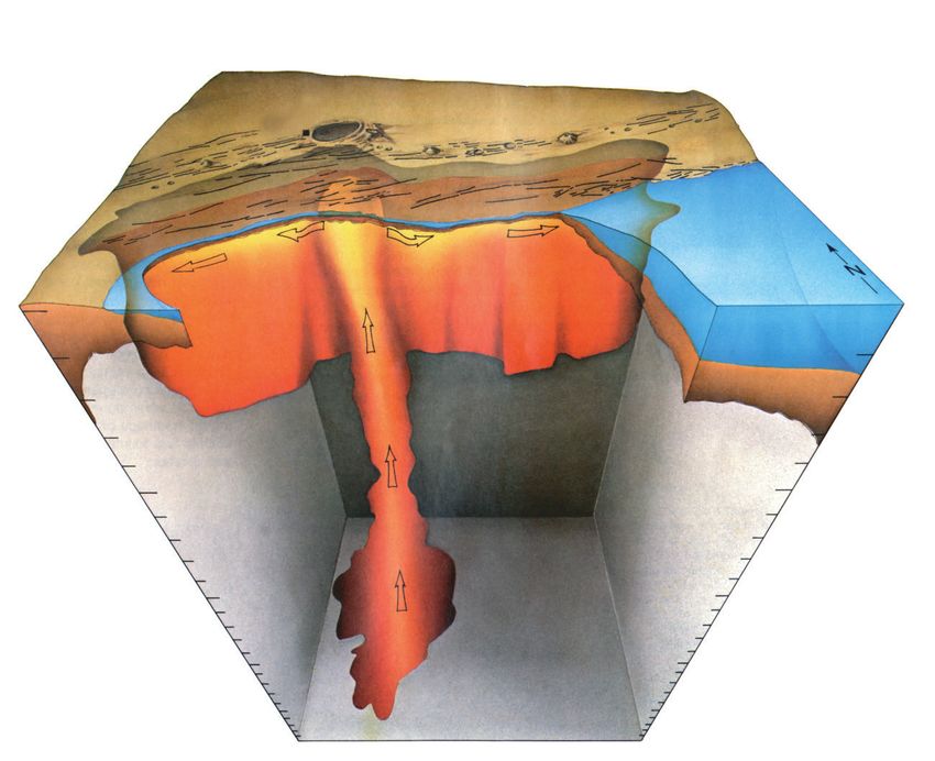
8Plate Tectonics and the Hawaiian “Hot Nearly all of the world's earthquakes and active
Spot” volcanoes occur along or near the boundaries of
the Earth's shifting plates. Why then are the Hawai-
In the early 1960s, the related concepts of ian volcanoes located in the middle of the Pacific
"seafloor spreading" and "plate tectonics" emerged Plate, more than 2,000 miles from the nearest
as powerful new hypotheses that geologists used to boundary with any other tectonic plate? The pro-
interpret the features and movements of the Earth's ponents of plate tectonics at first had no explana-
surface layer. According to the plate tectonic theory, tion for the occurrence of volcanoes within plate
the Earth's rigid outer layer, or "lithosphere," con- interiors (“intraplate” volcanism). Then in 1963, J.
sists of about a dozen slabs or plates, each averaging Tuzo Wilson, a Canadian geophysicist, provided an
50 to 100 miles thick. These plates move relative to ingenious explanation within the framework of plate
one another at average speeds of a few inches per tectonics by proposing the "hot spot" hypothesis.
year—about as fast as human fingernails grow. Sci- Wilson's hypothesis has come to be accepted widely,
entists recognize three common types of boundaries because it agrees well with much of the scientific
between these moving plates (see diagrams at right): data on linear volcanic island chains in the Pacific
(1) Divergent or spreading—adjacent plates Ocean in general—and the Hawaiian Islands in
pull apart, such as at the Mid-Atlantic Ridge, which particular.
separates the North and South America Plates from According to Wilson, the distinctive linear
the Eurasia and Africa Plates. This pulling apart shape of the Hawaiian-Emperor Chain reflects the
causes "seafloor spreading" as new material from progressive movement of the Pacific Plate over a
the underlying less rigid layer, or "asthenosphere," “deep” and “fixed” hot spot. In recent years, scien-
fills the cracks and adds to these oceanic plates. tists have been debating about the actual depth(s)
(2) Convergent—two plates move towards one of the Hawaiian and other Earth hot spots. Do
another and one is dragged down (or "subducted") they extend only a few hundred miles beneath the
beneath the other. Convergent plate boundaries lithosphere? Or do they extend down thousands of
are also called "subduction zones" and are typified miles, perhaps to Earth’s core-mantle boundary?
by the Aleutian Trench, where the Pacific Plate is Also, while scientists generally agree that hot spots
being subducted under the North America Plate. are fixed in position relative to the faster moving
Mount St. Helens (southwest Washington) and overriding plates, some recent studies have shown
Mount Fuji (Japan) are excellent examples of that hot spots can migrate slowly over geologic
subduction-zone volcanoes formed along conver- time. In any case, the Hawaiian hot spot partly melts
gent plate boundaries. the region just below the overriding Pacific Plate,
(3) Transform fault—one plate slides hori- producing small, isolated blobs of molten rock
zontally past another. The best-known example is (magma). Less dense than the surrounding solid
the earthquake-prone San Andreas Fault Zone of rock, the magma blobs come together and rise buoy-
California, which marks the boundary between the antly through structurally weak zones and ultimately
Pacific and North America Plates. erupt as lava onto the ocean floor to build volcanoes.
9A cutaway view along the Hawaiian island chain showing the inferred
mantle plume that has fed the Hawaiian hot spot on the overriding Pacific
Plate. The geologic ages of the oldest volcano on each island (Ma = mil-
lions of years ago) are progressively older to the northwest, consistent with
the hot spot model for the origin of the Hawaiian Ridge-Emperor Seamount
Chain. (Modified from image of Joel E. Robinson, USGS, in “This Dynamic
Planet” map of Simkin and others, 2006.)
Over a span of about 70 million years, the combined processes of The progressive northwesterly drift of the islands from their point of
magma formation, eruption, and continuous movement of the Pacific Plate origin over the hot spot is well shown by the ages of the principal lava flows
over the stationary hot spot have left the trail of volcanoes across the ocean on the various Hawaiian Islands from northwest (oldest) to southeast (young-
floor that we now call the Hawaiian-Emperor Chain. A sharp bend in the est), given in millions of years: Ni‘ihau and Kaua‘i, 5.6 to 3.8; O‘ahu, 3.4
chain about 2,200 miles northwest of the Island of Hawai‘i was previously to 2.2; Moloka‘i, 1.8 to 1.3; Maui, 1.3 to 0.8; and Hawai‘i, less than 0.7 and
interpreted as a major change in the direction of plate motion around 43–45 still growing.
million years ago (Ma), as suggested by the ages of the volcanoes bracket- Even for the Island of Hawai‘i alone, the relative ages of its five volca-
ing the bend. However, recent studies suggest that the northern segment noes are compatible with the hot-spot theory (see map, page 3). Kohala, at
(Emperor Chain) formed as the hot spot moved southward until about 45 Ma, the northwestern corner of the island, is the oldest, having ceased eruptive
when it became fixed. Thereafter, northwesterly plate movement prevailed, activity about 120,000 years ago. The second oldest is Mauna Kea, which
resulting in the formation of the Hawaiian Ridge “downstream” from the last erupted about 4,000 years ago; next is Hualälai, which has had only
hotspot. one eruption (1800–1801) in written history. Lastly, both Mauna Loa and
The Island of Hawai‘i is the southeasternmost and youngest island in the Kïlauea have been vigorously and repeatedly active in the past two centuries.
chain. The southeasternmost part of the Island of Hawai‘i presently overlies Because it is growing on the southeastern flank of Mauna Loa, Kïlauea is
the hot spot and still taps the magma source to feed its active volcanoes. The believed to be younger than its huge neighbor.
active submarine volcano Lö‘ihi, off the Island of Hawai‘i's south coast, may The size of the Hawaiian hot spot is not well known, but it presum-
mark the beginning of the zone of magma formation at the southeastern edge ably is large enough to encompass and feed the currently active volcanoes
of the hot spot. With the possible exception of Maui, the other Hawaiian of Mauna Loa, Kïlauea, Lö‘ihi and, possibly, also Hualälai and Haleakalä.
islands have moved northwestward beyond the hot spot—they were succes- Some scientists have estimated the Hawaiian hot spot to be about 200 miles
sively cut off from the sustaining magma source and are no longer volcani- across, with much narrower vertical passageways that feed magma to the
cally active. individual volcanoes.
10Hawaiian Eruptions in Recorded History
Hawai‘i has a brief written history, extending back only
about 200 years, compared to such volcanic regions as Iceland,
Indonesia, Italy, and Japan. Written accounts exist for most
Hawaiian eruptions since 1823, when the first American mission-
aries visited the Island of Hawai‘i. Descriptions of earlier erup-
tions are sketchier, because they are based only on interpretations
of ancient Hawaiian chants and stories told to the American mis-
sionaries by Hawaiian elders and early European residents.
All the known Hawaiian eruptions since 1778 have been at
Mauna Loa and Kïlauea Volcanoes, except for the 1800–1801
eruption of Hualälai Volcano on the west coast of the Island
of Hawai‘i. In an exception to the overall northwest-southeast
shift of volcanic activity, a series of minor submarine eruptions
probably occurred in 1955–56 between the islands of O‘ahu and
Kaua‘i and near Necker Island, about 350 miles northwest of
Kaua‘i.
For the past 200 years, Mauna Loa and Kïlauea have tended
to erupt on average every two or three years, placing them
among the most frequently active volcanoes of the world. At
each volcano, some intervals of repose between eruptions at a
given volcano have been much longer than its long-term aver-
age. The individual Kïlauea eruptions recorded since 1778 are in
addition to the nearly continuous eruptive activity within or near
Halema‘uma‘u Crater, extending throughout the 19th century
and into the early 20th century.
On March 30, 1984, Kïlauea and Mauna Loa were in simultane-
ous eruption, the first time since 1924. Above: Kïlauea's Pu‘u ‘Ö‘ö
vent during its 17th high-fountaining episode. Below: Aerial view
of a long lava flow during the Mauna Loa eruption, which began on
March 25; this eruption fed a major lava flow that advanced toward
the city of Hilo. (Upper photograph by Edward W. Wolfe, USGS;
lower photograph by Scott Lopez, National Park Service.)
11Graph summarizing the eruptions of Mauna Loa and Kïlauea Volcanoes during the past 200 years. The Pu‘u ‘Ö‘ö- Kupaianaha eruption has continued into the 21st century. Information is sketchy for eruptions before 1823, when the first missionaries arrived on the Island of Hawai‘i. The total duration of eruptive activity in a given year, shown by the length of the vertical bar, may be for a single eruption or a combination of several separate eruptions. 12
Except for the nearly continuous eruptive activity
                                                                                                              at Halema‘uma‘u for a century before 1924, the
                                                                                                              Pu‘u ‘Ö‘ö-Kupaianaha eruption—still continuing
                                                                                                              through 2010—has now become the longest last-
                                                                                                              ing Hawaiian eruption in recorded history.
                                                                                                                   In mid-March 2008, a new vent opened
                                                                                                              within Halema‘uma‘u Crater, and a faint glow
                                                                                                              could be seen at night. Early on the morning of
                                                                                                              March 19, a small explosion occurred at this
                                                                                                              vent—the first explosive activity at Kïlauea’s
                                                                                                              summit since 1924. Rock debris from the explo-
                                                                                                              sion—with a few blocks as large as a yard
                                                                                                              across—was strewn over about 75 acres, covered
                                                                                                              a stretch of Crater Rim Drive, and damaged
                                                                                                              the Halema‘uma‘u visitor overlook. People in
                                                                                                              Pahala (~ 20 miles downwind) reported a light
                                                                                                              dusting of ash on their cars. In early September
                                                                                                              2008, molten lava was observed bubbling and
                                                                                                              sloshing within the pit, and lava has been present
                                                                                                              intermittently into 2010. As the summit activity
                                                                                                              continued—characterized by heavy fuming with
The active lava lake within Halema‘uma‘u Crater overflowing its levee, as painted by D. Howard Hitchcock in   elevated sulfur dioxide emissions, nighttime glow,
1894. Snow-capped Mauna Loa forms the far horizon. (USGS photograph by J.D. Griggs, with permission of        and occasional explosions—the vent was enlarged
the Volcano House Hotel, owner of the original painting.)
                                                                                                              by repeated wall collapses, becoming about 450
                                                                                                              feet in diameter and 650 feet deep by April 2010.
     Simultaneous eruption of both volcanoes                 Since July 1950, Hawaiian eruptive activity      The 2008–present Halema‘uma‘u activity is the
has been rare, except at times when Kïlauea was         has been dominated by frequent and sometimes          longest summit eruption at Kïlauea since 1924.
continuously active before 1924. The only post-         prolonged eruptions at Kïlauea, while only two             For the first year, the eruption at the new
1924 occurrence of simultaneous eruption was            short-lived eruptions have occurred at Mauna          summit vent had no appreciable effect on the con-
in March 1984, when activity at both volcanoes          Loa (July 1975 and March–April 1984). As of           tinuing eruption near Pu‘u ‘Ö‘ö, marking the lon-
overlapped for one day. Long repose intervals           2010, Kïlauea’s Pu‘u ‘Ö‘ö-Kupaianaha eruption,        gest known occurrence of simultaneous summit
for one volcano correlate approximately with            which began in January 1983, showed no signs          and rift eruptions at Kïlauea. Past simultaneous
increased activity at the other. This general rela-     of decline. This eruption has been primarily fed      activity, such as in 1971, was rare and of short
tion is imperfect but holds well for post-1924          by the Pu‘u ‘Ö‘ö vent, except for two extended        duration, generally lasting only a few days at
eruptive activity. Between 1934 and 1952, only          periods: (1) July 1986–February 1992 at the           most. The ongoing concurrent summit-rift erup-
Mauna Loa was active; between 1952 and 1974,            Kupaianaha vent; and (2) July 2007–present at         tion, now approaching three years in duration, is
only Kïlauea was.                                       vents about a half mile uprift from Kupaianaha.       unprecedented for Kïlauea in recorded history.

                                                                                                                                                              13
Above: Aerial view in November 2008 of the gas plume from the new vent that opened in Halema‘uma‘u
Crater in mid-March 2008. This activity has continued into 2010 and can be conveniently seen from the
Jaggar Museum and the Hawaiian Volcano Observatory (circled) on the rim of Kïlauea Caldera. Left:
Nighttime look (January 2010) through the fume at the molten lava sloshing and bubbling within the
Halema‘uma‘u vent, about 400 feet in diameter. (USGS photographs by Tim Orr.)
A pattern of dominant activity alternating between Mauna Loa and The average volume of lava erupted at Kïlauea Volcano since 1956 is
Kïlauea could imply that both volcanoes may alternately tap the same deep between 110 and 130 million cubic yards per year. In contrast, the aver-
magma source. Whether this is so is a topic of scientific debate and con- age rate of lava output along the entire Hawaiian-Emperor Chain during
tinuing research, because abundant physical evidence indicates that each its 70-million-year life is only about 20 million cubic yards per year. For
volcano has its own shallow magma reservoir that operates independently of reasons not yet understood, the rate of eruptive activity associated with the
the other. Also, available data suggest that the lavas of the two volcanoes are Hawaiian hot spot for the past few centuries appears exceptionally high
chemically and isotopically distinct. relative to its long-term average.
14Volcano Monitoring and which devastated the city of St. Pierre and killed
about 30,000 people.
Research In 1911, spurred by a stimulating lecture
delivered by Jaggar, a group of Hawaiian resi-
Before the 20th century, most scientific dents founded the Hawaiian Volcano Research
studies of volcanoes were conducted during Association (HVRA). The logo of the HVRA
short-lived expeditions, generally undertaken included the motto Ne plus haustae aut obrutae
as a response to major eruptions. Thomas A. urbes (loosely translated as “Let no more cities
Jaggar, Jr., a geologist at the Massachusetts be destroyed or buried”), reflecting Jaggar's
Institute of Technology (MIT), was not satis- memory of Mont Pelée's destructive force and
fied with that approach. He recognized that, to his optimistic belief that better understanding
understand volcanoes fully, one must study them of volcanoes could reduce the hazard to life and
The first Hawaiian Volcano Observatory (HVO), continuously before, during, and after eruptions. property from eruptions.
located near the site of the present Volcano House
Jaggar's views were profoundly affected by a In 1912, with support from the HVRA and
Hotel, as it appeared around 1922. (Photographer
unknown; courtesy of the Bishop Museum, Hono- memorable visit in 1902 to the Island of Marti- the Whitney Fund of MIT, Jaggar established the
lulu, Hawai‘i.) nique (West Indies). He went as a member of the Hawaiian Volcano Observatory (HVO) to study
international scientific expedition sent to study the activity of Mauna Loa and Kïlauea on a per-
that year's catastrophic eruption of Mont Pelée, manent, scientific basis. "Volcanology" emerged
as a modern science with the founding of HVO,
which between 1912 and 1948 was managed by
the HVRA, the U.S. Weather Bureau, the U.S.
Geological Survey (USGS), and the National
Park Service. Since 1948, it has been operated
by the USGS.
During the past nearly 100 years of
research, HVO scientists have developed and
refined most of the surveillance techniques now
commonly employed by volcano observatories
worldwide.
Helicopter view of HVO at its present site on the
western edge of Kïlauea Caldera, after renovation
and the addition of a new wing (with observation
tower) in 1986. In the background, fume rises from
the active vent within Halema‘uma‘u Crater on
the caldera floor. (USGS photograph by Tim Orr,
November 2010.)
15Volcano Monitoring Tilt changes and associated relative vertical
displacements can also be detected by periodic
The term "volcano monitoring" refers to remeasurement of arrays of benchmarks by lev-
the observations and measurements—visual eling, a high-precision field surveying method.
and instrumental—scientists make to docu- Changes in horizontal distances between bench-
ment changes in the state of a volcano during marks can be monitored in the field by using
and between eruptions. Such changes are now portable electronic-distance-measurement
well known for Kïlauea, and a pattern of similar (EDM) instruments that use laser or infrared
changes is becoming apparent for the less stud- beams. Collectively, these commonly used
ied Mauna Loa. As magma enters the shallow ground-deformation monitoring techniques have
summit reservoir, the volcano undergoes swell-
ing or inflation (a process similar to the stretch-
ing of a balloon being filled with air). This
swelling in turn causes changes in the shape of
the volcano's surface. During inflation, the slope
or tilt of the volcano increases, and reference
points (benchmarks) on the volcano are uplifted
relative to a stable point and move farther apart
from one another. For Hawaiian volcanoes, pre-
eruption inflation is generally slow and gradual,
lasting for weeks to years. However, once an
eruption begins, the shrinking or deflation of
the volcano typically occurs rapidly as pressure
on the magma reservoir is suddenly relieved—a Above: Hawaiian Volcano Observatory
process not unlike deflating a balloon. During (HVO) scientists use a laser-ranging instru-
deflation, changes in tilt and in vertical and ment in the mid-1980s to make an electronic
distance measurement (EDM). Snow-capped
horizontal distances between benchmarks are
summit of Mauna Loa can be seen in back-
opposite to those during inflation. ground. (USGS photograph by J.D. Griggs.)
Changes in the shape of the volcano during Below: An HVO scientist takes notes at a
inflation and deflation are determined by global positioning system (GPS) measure-
ground-deformation measurements. Tilt changes Hypothetical slice through Kïlauea Volcano. Magma ment site near the Pu‘u ‘Ö‘ö vent, while an
can be measured continuously and extremely entering the shallow reservoir exerts pressure on the vol- antenna receiver (on tripod centered over a
precisely by use of instruments called tiltmeters, cano, causing earthquakes and distorting its shape from benchmark) acquires signals emitted from
which can detect a change in angle of less than 1 the dashed-line profile to the solid-line profile. During several GPS satellites. Mauna Kea Volcano
inflation, reference points (benchmarks) on the volcano's is visible in background. Repeated measure-
microradian (about 0.00006 degree). A 1-micro-
surface are pushed upward and outward relative to ments at the same benchmark will reveal
radian increase in tilt would be equivalent to points assumed to be stable. Changes in the volcano's horizontal and vertical motions of that point
steepening the slope of a board about 0.8 mile shape and the occurrence of the earthquakes can be on the volcano. (USGS photograph by Chris-
long by placing a coin under one end. tracked precisely by volcano-monitoring techniques. tina Heliker.)
16a measurement precision of a few parts per mil- the volcano summits, GPS measurements show cessing radar signals sent by an orbiting satel-
lion or less. For distances, the notion of one part that the south flank of Kïlauea and, at times, lite and bounced back from the ground surface.
per million (ppm) can be visualized as about 1 the southeast flank of Mauna Loa are moving Changes in the position of the Earth’s surface
inch in 16 miles, or one car length in bumper-to- seaward (to the southeast) at an average rate of a can be determined by analyzing a pair of radar
bumper traffic from Cleveland to San Francisco. few inches per year. As the costs and computer- images acquired at two different times. Like
During the past 15 years, the global posi- processing time of GPS measurements continue GPS measurements, InSAR monitoring can
tioning system (GPS)—a satellite-based tech- to decrease, they will likely replace all other be done in all weather conditions and can map
nology—has been increasingly used to monitor types of ground-deformation measurements, ground deformation over a wide area (typically
the ground movements at active volcanoes. especially since GPS measurements can be made 30 x 60 miles). InSAR data cover a large area
Originally deployed for military purposes by around the clock regardless of the weather and but are obtained and processed periodically,
the Department of Defense, the GPS involves do not require one benchmark to be seen from whereas GPS measurements refer to specific
an array of 24 satellites (orbiting about 12,000 another. points (benchmarks) but can be made frequently
miles above the Earth) that continuously send In recent years, there has been increas- or even continuously. Taken together, data from
very accurate time signals, which can be picked ing use of another satellite-based tool to track these two techniques are complementary and
up by GPS receivers on the ground. Using high- ground deformation at Hawaiian and other give a better picture of the overall ground defor-
resolution GPS receivers (not the inexpensive volcanoes—Interferometric Synthetic Aperture mation than measurements obtained through
devices used by hikers and drivers) and sophis- Radar (InSAR). This technique involves pro- either technique by itself.
ticated computer processing of signals received
from four or more satellites, scientists can
determine both distance (longitude and latitude)
and elevation changes at a given ground refer-
ence point ("benchmark") with parts-per-million
precision. Repeated measurements of a GPS
network of many benchmarks make it pos-
sible to monitor an entire volcano. In addition
to monitoring inflation/deflation movements at
Areas of color bands, or "fringes," in this InSAR image—produced from a pair
of satellite radar images acquired 35 days apart in 2007 by the European
Space Agency's ENVISAT satellite—show subsidence at Kïlauea's summit
caldera and a combination of uplift and subsidence centered near Makaopuhi
Crater. This pattern of deformation reflects an intrusion of magma from the
summit reservoir into the east rift zone. Each fringe of color bands (violet-
blue-green-yellow-red) represents about 1.1 inch of deformation (up or down)
of the ground surface. In this image, a progression of yellow-to-violet colors
toward the center of a pattern demonstrates uplift, and the opposite color pro-
gression indicates subsidence. (Image courtesy of Michael Poland, USGS.)
17The mainstay of volcano monitoring is the continuous recording of seis- the volcano observatory. Seismic data are analyzed to determine the time,
mic activity. Virtually all Hawaiian eruptions are preceded and accompanied location, depth, and magnitude of earthquakes. Mapping earthquake activity
by an increase in the number of shallow earthquakes. As magma moves into allows HVO scientists to track the subsurface movement of magma.
the reservoir during inflation, it must make room for itself by rupturing or All Hawaiian eruptions are accompanied by volcanic tremor. Quite dis-
crowding aside the solidified lava that surrounds the reservoir. Such under- tinct from the discrete seismic shocks associated with rupture-caused earth-
ground ruptures produce seismic waves that travel through the volcano and quakes, volcanic tremor is a continuous vibration of the ground caused by
are recorded by a network of seismometers placed on the volcano's surface. movement of fluids (magma or gas). Volcanic tremor generally is detectable
Ground motions sensed by seismometer are converted into electronic signals, and recorded only by seismic instruments; however, if especially vigorous,
which are transmitted by radio and are recorded on seismographs located at tremor can be felt by people as far as 5 miles from an eruption site.
Short-period earthquake
distant
nearby
Long-period earthquake
Above center: On this seismograph, a sharp-needle pen “writes” the seismic signatures with a hot stylus on heat-
sensitive paper wrapped around a recording drum. (USGS photograph by J.D. Griggs.) For modern-day precise
monitoring, however, HVO records and analyzes seismic activity with computer recording and processing systems.
Volcanic tremor Left: Examples of common seismic signatures typically recorded before and during eruptions. Above right: An
example of a computer display of digital traces of seismic signals recorded by the network of broadband seismome-
ters around Kïlauea summit. Here, we see the seismic signals produced by the explosions on the morning of March
19, 2008, that initiated the eruption within Halemau‘ma‘u Crater, which still continues in 2010. (Modified from image
of Phillip B. Dawson, USGS.)
18Volcano-Monitoring Networks on Hawai‘i
Seismic station GPS network
Continuously recording
Kohala Kohala GPS site
GPS survey benchmark
20˚ 00' 20˚ 00'
Mauna Kea Mauna Kea
Hualälai
Hualälai
HVO
19˚ 30' Mauna 19˚ 30' Mauna Kïlauea
Loa Kïlauea Loa
Principal volcano-monitoring networks operated by the 19˚ 00'
0 20 km
19˚ 00'
0 20 km
Hawaiian Volcano Observatory. The configurations of the 0 10 miles 0 10 miles
networks evolve with time—to adapt to new technologies, to
156˚ 00' 155˚ 30' 155˚ 00'
upgrade systems, and to meet changing needs dictated by 156˚ 00' 155˚ 30' 155˚ 00'
eruptive activity. Tilt/strain network
Level lines
Electronic tiltmeter
Tilt survey array
Kohala Strainmeter Kohala
20˚ 00' 20˚ 00'
Mauna Kea Mauna Kea
Hualälai Hualälai
Mauna Mauna
19˚ 30'
Loa Loa
19˚ 30'
Kïlauea Kïlauea
19˚ 00' 19˚ 00'
0 20 km 0 20 km
0 10 miles 0 10 miles
156˚ 00' 155˚ 30' 155˚ 00' 156˚ 00' 155˚ 30' 155˚ 00'
19Summit Tilt of Kïlauea 1956–2009
Mauna Ulu Pu‘u ‘Ö‘ö - Kupaianaha eruption
800 eruption (still continuing in 2010) 800
Tilt, in microradians
Inflation
Kïlauea Iki
600 eruption 600
= Eruption
= Intrusion
400 Halema‘uma‘u 400
eruption
Deflation
200 200
0
1956 1960 1965 1970 1975 1980 1985 1990 1995 2000 2005 2010
Yea r
Pu‘u ‘Ö‘ö - Kupaianaha Eruption, January–June 1986
40 41 42 43 44 45 46 47
microradians
Summit
tilt 30 30
Tilt, in
20 20
No
10 data 10
Eruptive 0 0
episode
2500
summit earthquakes
Number of volcanic
summit earthquakes
Number of tectonic
1000
2000
800
No data
Shor t-period
1500
No data
(tectonic) 600
ear thquakes
1000 400
500 200
Long-period 0 0
(volcanic) Januar y February March April May June
ear thquakes
Above: The common pattern of gradual inflation, followed by abrupt deflation, is well demonstrated by changes in “tilt” of the vol-
cano’s slopes associated with major eruptions and intrusions at Kïlauea. A change in tilt of 1 microradian equals an angle of 0.00006
degree. With the onset of the Pu‘u ‘Ö‘ö-Kupaianaha eruption in 1983, Kïlauea summit underwent long-term net deflation until late
2003, when this trend reversed for several years. Summit deflation resumed in 2007 and has continued through 2010. (Tilt data plot-
ted by Asta Miklius, USGS.) Below: A detailed look at a 6-month segment of the tilt record reveals similar inflation-deflation patterns
for the high-lava-fountaining episodes of the Pu‘u ‘Ö‘ö-Kupaianaha eruption, even though the tilt changes and time intervals involved
are much smaller (compare scales of the two diagrams). Also shown are variation patterns of the two types of earthquakes that com-
monly precede and accompany Kïlauea eruptions.
20Anatomy of an Eruption: The Inflation-Deflation Cycle and (or) pauses during activity at the Pu‘u ‘Ö‘ö vent since July 2007 and are
thought to reflect variations in magma supply to a shallow storage zone just
Kïlauea's behavior during and between eruptions is remarkably regular. east of Halemau‘uma‘u Crater.
Monitoring instruments placed at the volcano's summit can be used to trace
the cycles of gradual inflation, during which the reservoir fills with magma,
and abrupt deflation, when the reservoir partially empties to deliver magma Forecasting Eruptions
to an eruption. These recurring inflation-deflation cycles are precisely
recorded by tiltmeters and seismometers, as is well displayed during the A prime objective of volcano monitoring is to detect the early signs of
1983-to-present Pu‘u ‘Ö‘ö-Kupaianaha eruption. possible eruptive activity and to make reliable eruption forecasts. Although
During inflation, rocks surrounding the magma reservoir become considerable advances have been made in volcano monitoring in Hawai‘i,
stressed. This stress is partly relieved by increasing numbers of earthquakes accurate long-term forecasts (one year or longer) still elude scientists. How-
that are too small to be felt but are easily recorded by seismometers at ever, the capability for short-term forecasts (hours to months), especially of
Kïlauea’s summit. These earthquakes (called short-period or tectonic) are Kïlauea’s activity, is much better.
recorded as high-frequency features on a seismograph. During deflation Accurate short-term forecasts of Hawaiian eruptions are based pri-
the stress is completely relieved. The short-period earthquakes stop, but marily on analyses of inflation-deflation patterns, made possible through
their place is taken by low-frequency earthquakes (called long-period or decades of study of ground deformation (tilt) and seismicity (earthquakes
volcanic), which reflect adjustments related to the exit of magma from the and volcanic tremor). When the level of inflation and the short-period
summit reservoir to feed the eruption. Long-period earthquakes are related earthquake counts are high, the volcano is ready to erupt. Sometimes there
to harmonic tremor, the continuous vibration of the ground associated with is a delay of days or even weeks before eruption occurs, but scientists are
underground magma or fluid movement. alerted by the patterns and are ready to study the eventual outbreak when it
Kïlauea’s distinctive inflation-deflation pattern is seen in nearly every does occur. Eruption is signaled by the beginning of sharp deflation accom-
eruption, regardless of the size of the observed tilt changes. For example, panied by either harmonic tremor or earthquakes close to the site of eruptive
the pattern is dramatically apparent for the Kïlauea Iki eruption in 1959, outbreak. These signals are usually seen an hour to several hours before lava
which involved the largest tilt change recorded to date (nearly 300 microra- breaks the surface, allowing scientists enough time to travel to the likely site
dians). The same pattern is also well seen in activity involving smaller tilt of activity and issue warnings.
changes (20 microradians or less), as observed during the continuous erup- The combination of seismic and ground-deformation monitoring has
tion of the Pu‘u ‘Ö‘ö vent in January–June 1986. proved to be the most useful and reliable method in the short-term forecast-
Less commonly observed at Kïlauea in the summit tilt record, and ing of Kïlauea eruptions. However, some other techniques being developed
sometimes also recorded by a tiltmeter at Pu‘u ‘Ö‘ö, is a deflation-inflation or tested show promise and should increase future forecasting capabilities.
pattern (called a “DI tilt event”) that typically lasts less than a week. A DI These newer methods include the monitoring of changes in the composition
event is characterized by an abrupt deflation as large as a few microradians and volume of volcanic gas emissions, such as sulfur dioxide, carbon diox-
lasting several hours to 2–3 days, which is followed by a sharp inflation of ide, hydrogen, helium, and radon; magnetic and gravitational fields of the
about equal tilt change over several days. This type of tilt pattern was first volcano; and various geoelectrical properties of the volcano. Some of the
recognized in August 2000, but it has become increasingly more common gas-monitoring techniques can make measurements with parts-per-million
since 2004, especially after 2008. The eruption dynamics of DI events are (ppm) precision. For gases and fluids, one ppm can pictured in terms of a
not yet understood. However, these events tend to correlate with lava pulses very dry martini—1 drop of vermouth in 16 gallons of gin!
21A scientist uses a correlation spectrometer (COSPEC) to measure
the emission of sulfur dioxide gas from the Pu‘u ‘Ö‘ö vent. This
instrument—originally developed to monitor atmospheric pollution by
measuring sulfur dioxide discharge from industrial smokestacks—
has largely been replaced by instruments that are more sensitive, A Fourier Transform InfraRed (FTIR) spectrometer is used to analyze volcanic gases emit-
lighter in weight, less cumbersome, and of lower cost. (USGS photo- ted from a glowing vent. This instrument (closeup in inset) is capable of analyzing many
graph by J.D. Griggs.) other species of volcanic gases in addition to sulfur oxide and carbon dioxide. (USGS
photograph by A.J. Sutton.)
In recent decades, great strides have been made in gas monitoring using far, data from the nonseismic and nongeodetic monitoring techniques have
satellite- and ground-based remote-sensing instrumentation and techniques. not revealed definitive short-term precursors to possible eruptions. However,
With various types of field-portable spectrometers, HVO scientists con- they have identified underground movement of magma from one place to
tinuously measure the emission of sulfur dioxide and carbon dioxide at another, sometimes unaccompanied by measurable ground deformation or
the summit calderas of Kïlauea and Mauna Loa. They also make repeated, earthquakes. Experience on well-studied active volcanoes in Hawai‘i and
though not continuous, measurements of gas output at eruptive vents and elsewhere has shown that the best volcano monitoring is achieved by using a
other specific sites. HVO’s near-real-time monitoring of volcanic-gas emis- combination of approaches rather than relying on any single method.
sions from the ongoing eruptions at Pu‘u ‘Ö‘ö and Halema‘uma‘u provides At present, HVO scientists generally can identify an increased potential
key information to the National Park Service and Hawai‘i County for for Kïlauea or Mauna Loa eruptions and the likely locations of lava out-
assessment of potential hazards to visitors and residents from volcanic air breaks, but they cannot make specific forecasts of the exact timing or size of
pollution (discussed later). an expected eruption. However, for a number of Kïlauea eruptions in recent
Other monitoring techniques are also proving useful—data from decades, the HVO staff has been able to warn officials of Hawai‘i Volcanoes
magnetic, gravity, and geoelectrical studies provide diagnostic information National Park and (or) the County of Hawai‘i, hours to days in advance, to
about the subsurface configuration and workings of a volcanic system. So take safety measures, if deemed necessary.
22You can also read