The emplacement of pahoehoe lavas on Kilauea and in the Deccan Traps
←
→
Page content transcription
If your browser does not render page correctly, please read the page content below
The emplacement of pahoehoe lavas on Kilauea and in the
                        Deccan Traps
                                           H. C. SHETH

              Department of Earth Sciences, Indian Institute of Technology (IIT) Bombay,
                     Powai, Mumbai 400 076, India (email: hcsheth@iitb.ac.in)

There is growing interest in deciphering the emplacement and environmental impact of flood basalt
provinces such as the Deccan, India. Observations of active volcanism lead to meaningful interpretations
of now-extinct volcanic systems. Here, I illustrate and discuss the morphology and emplacement of the
modern and active lava flows of Kilauea volcano in Hawaii, and based on them, interpret the compound
pahoehoe lavas of the Deccan Traps. The latter are vastly larger (areally extensive and voluminous) than
Kilauea flows, and yet, their internal architecture is the same as that of Kilauea flows, and even the sizes
of individual flow units often identical. Many or most compound flows of the Deccan Traps were
emplaced in a gentle, effusive, Kilauea-like fashion. Bulk eruption rates for the Deccan province are
unknown, and were probably high, but the local eruption rates of the compound flows were no larger than
Kilauea’s. Large (≥1000 km3) individual compound pahoehoe flows in the Deccan could have been
emplaced at Kilauea-like local eruption rates (1 m3/sec per metre length of fissure) in a decade or less,
given fissures of sufficient length (tens of kilometres), now exposed as dyke swarms in the province.

Keywords. Volcanism; lava; Kilauea; Hawaii; Deccan; flood basalt

                                          1. Introduction

The emplacement and environmental impact of flood basalt eruptions have been topics of much interest
and debate in recent years (see e.g., Self et al 1997; Bondre et al 2004a,b and references therein; Wignall
2005). Several flood basalt episodes in Earth history overlapped with major mass extinctions, and may
have been their cause, though several other flood basalt episodes were not associated with mass
extinctions (Wignall 2005; Kerr 2005). The celebrated Deccan flood basalts of India overlapped with the
major Cretaceous/Tertiary Boundary mass extinctions ~65 million years (m.y.) ago (e.g., McLean 1985).
The ambiguity in relating specific flood basalts to particular mass extinctions is due to geochronological
data that are insufficiently precise to establish exact temporal coincidence (Baksi 2001), inadequate
morphological characterization of many old flood basalts, and insufficient knowledge of their
emplacement mechanisms and pre-eruptive volatile contents.

         Here, I discuss the morphology and emplacement mechanisms of the compound pahoehoe lavas
of the Deccan Traps, one of the major flood basalt provinces of the world, and draw exact parallels with
recent and active lava flows of the Kilauea volcano in Hawaii, world’s most active and intensely studied
volcano. This paper is not intended to provide elaborate discussions of the morphological features and
emplacement of the Deccan lavas, which appear in recent exhaustive overviews (Bondre et al 2004a,b).
This paper also does not attempt an overview of the morphology of lava flows and volcanic systems in
general, for which the reader is referred to a nicely illustrated website managed by Vic Camp, located at
www.geology.sdsu.edu/how_volcanoes_work. Here, I offer field data on the morphology and
emplacement of the Kilauea and the Deccan compound flows, based on first-hand observations in both
provinces. I then discuss the significance of the data in understanding the eruption rates of the Deccan
lavas, note some prevailing misconceptions in Deccan volcanology, and end with some comments and
thoughts on the likely environmental impact of the extensive and voluminous Deccan compound lava
flows. I begin with a brief description of Kilauea’s lava flows.

                                                                                                  1
2. Kilauea and its active lava flows

Observations of active volcanism are invaluable, as these allow meaningful interpretations to be made of
now-extinct volcanic systems. Active volcanoes of the islands of Hawaii in the Pacific Ocean (Figure 1)
have been very important to the development of volcanology and igneous petrology. These islands are
merely the exposed tops of huge shield volcanoes which rise some 10 km from the ocean floor and yet
have gentle gradients. The geology of the Hawaiian islands is only too well known from scores of
technical and popular articles (e.g., Macdonald et al 1983; Hazlett and Hyndman 1996; TenBruggencate
2000; Decker and Decker 2001; Sheth 2003), and I will merely present a very basic (and perhaps
oversimplified) introduction which will, nevertheless, help the reader understand the arguments advanced
in a later section for the Deccan lavas. Apart from the submarine volcano Loihi at the southeastern end of
the Hawaiian island chain, the two active shield volcanoes situated on the “Big Island” of Hawaii are
Mauna Loa (rising 4166 m above sea level, last eruption in 1984) and Kilauea (1248 m above sea level,
last eruption ongoing since 1983; see the website of the Hawaiian Volcano Observatory, U. S. Geological
Survey, at http://hvo.wr.usgs.gov). Kilauea is the most active and most “safe” volcano on Earth that
almost always emits fluid lava and has rarely had explosive ash eruptions during the last few centuries. A
presently active vent on Kilauea is a cone known as Pu’u’ O’o’. After erupting from the crater at the top
of the cone, the lava flows downslope and towards the ocean. The lava mixing with sea water
immediately quenches and shatters and makes new land and this is how these volcanic islands grow.

        Some of the lava, after coming out of the vent, moves in open channels, where it is exposed to the
atmosphere. It therefore quickly loses heat and becomes highly viscous, rough, and clinkery. Such lava is
known by the Hawaiian name aa. Open lava channels can also develop solid roofs by cooling, and the
remaining lava moves underground in a lava tube. Lava flowing in a tube is not visible, except through
openings (skylights) in the solid roof of the tube. Surface breakouts from the roofs of lava tubes bring
lava out on the surface (Figure 2). Breakouts happen as the lava is progressing internally toward the ocean,
underground, and these breakouts continually increase the vertical thickness and lateral extent of the
whole lava flow.

         Structures preserved in solidified lava indicate the nature of flow (turbulent or laminar), which
depends on the viscosity of the lava. Lava flowing rapidly on steep slopes tends to break up and form
viscous aa. Viscosity is inversely proportional to temperature and directly proportional to silica content.
Kilauea (and in general, Hawaiian) lavas are basalts erupted at ~1200 oC and are rather fluid. “Ropy”
structures are very characteristic of the upper surfaces of individual lobes of the more fluid basalt lavas in
Hawaii. The forms on these surfaces resemble cords, or ropes, and the appearance is similar to the
wrinkled surface of an elephant’s trunk (Figure 2). The Hawaiian word for this type of lava is pahoehoe.
Ropy structure is not found in aa flows. Ropy structure begins to form at the front of a newly emplaced
pahoehoe lobe as it comes to rest. The frontal part stops moving, but as new lava is being supplied at the
rear end of the lobe, it crumples the cooler viscoelastic skin of the lobe into folds. Besides, these ropes get
pulled outward by the lava moving beneath, but because the velocity of the lava is maximum along the
central part of an elongated lobe, and least along its margins, the ropes on the skin become convex
outward. If eventually the lava cannot be held by the lobe whose frontal part is chilled and at rest, the lobe
bursts, and new lobes form. The lava shows shades of yellow to orange immediately as it comes out of a
crack in the crust of a lava tube, or a previously emplaced lobe, and turns dull orange and then red and
finally dark gray as it solidifies. For small lobes which cool quickly, this colour change takes only a few
tens of seconds. The lobes develop laterally, and pile up above each other, and the lava flow as a whole
enlarges its length, width and thickness (Figure 3). For old lavas, convex ropes preserved in pahoehoe
lobes are a useful flow direction indicator, but it is hazardous to extrapolate from a few exposed lobes to
the entire lava flow. In a single pahoehoe lava flow there can be thousands of individual lobes, and these
can have their individual flow directions at any angle (even 180o) to the direction of progression of the
lava flow as a whole. Thus the lava flow direction inferred from an individual lobe is always purely local.

                                                                                                    2
While breakouts are happening, remember that a lot more lava is continuously flowing under the
surface. Most large lava flows are able to spread far and wide not by surface flow, but by flow in a
network of large tubes underneath a cooled crust (Cashman et al 1998; Keszthelyi and Self 1998;
Kauahikaua et al 1998). This enables the lava to lose very little heat as it travels away from the vent.
Some long lava flows in the western USA are known to have lost so little heat during insulated transport
that they covered distances of several hundred kilometres from their eruptive vents before solidifying
(Self et al 1997). If lava is continually being supplied to a lobe though slowly, the outer cooled crust
slowly lifts up, the lobes swell over hours to days, and may coalesce into larger units (Hon et al 1994).
This is known as ‘inflation’. Old inflated lava lobes can be recognized through their characteristic internal
structure, which consists of an upper and a lower crust separated by a thicker core zone, and the
arrangement of vesicles. Vesicles are seen arranged both as vertical cylinders, which form as dissolved
gases in the liquid rise upward due to their buoyancy, and as horizontal rows, formed as the rising gases
encounter the overlying cold crust and turn horizontally under this mechanical barrier. The reader is
referred to Self et al (1997) for a detailed description of this process, but features related to inflation, such
as lava lobes with the characteristic structures, tumuli and squeeze-ups (Figure 4), have been extensively
described from the Deccan (e.g., Bondre et al 2000, 2004a,b; Duraiswami et al 2001, 2002, 2003).

                               3. The compound flows of the Deccan Traps

The ~65 million-year-old Deccan “large basaltic province” (LBP, Sheth 2006; Figure 5) is most
spectacularly exposed in the Western Ghats (Sahyadri) range beside the western Indian rifted margin, and
has been intensely studied for stratigraphy and geochemistry, the stratigraphic thickness here reaching 3
km. This sequence has been divided into various formations and constituent members and flows, based on
field criteria, geochemistry, and magnetic polarity. Despite considerable advances made in the chemical
characterization of the Deccan Trap lava flows, systematic morphological studies and mapping of these
huge lava flows have barely begun yet, but there is growing interest in these (e.g., Sengupta and Ray
2006). The lower half of the Western Ghats stratigraphy, and about half of the total (500,000 km2)
present-day areal extent of the province (Figure 5), is made up almost wholly of “compound” flows, i.e.,
flows made up of many subequal-sized lobes or flow units (Walker 1971; Keszthelyi et al 1999; Sheth
2003; Bondre et al 2004a,b). Many such large compound flows or flow fields, traceable over distances of
100 km or more, and 100 m or so thick, have volumes ≥1000 km3, and comprise thousands of individual
flow units. Interestingly, these flows have a morphology and internal structures (e.g., ropy structures,
tumuli) very like those of the Hawaiian lavas (Figure 4; e.g., Duraiswami et al 2001, 2002; Bondre et al
2004a,b). This means that observations of modern Hawaiian lava flows can be usefully applied in
understanding the eruption mechanisms of the much older Deccan lava flows. The Deccan certainly
shares many features with active volcanic regions such as Hawaii and Iceland (this study; Sheth 2003;
Sheth et al 2004), and continental flood basalts (Jerram 2002; Waichel et al 2006).

         Figure 6a shows a sketch by Walker (1971) of a compound flow he examined at the Mula dam
site, north of Ahmednagar. It is clear that the flow unit size is the same as that of active Kilauea flows
(see Figures 2-4; many more photos available from HCS). Figures 6b and 6c show sketches of compound
pahoehoe flows, with similarly small flow units, in the Sangamner area in the Deccan (Bondre et al
2004a). Figure 6d shows a compound flow with much larger flow units in the Sangamner area, in which
clear evidence for inflation was observed (Bondre et al 2000). Figure 6e shows a section in the Trimbak
area mapped by Walker (1971), exposing tens of flow units over tens of metres. Most of these Deccan
compound flows are internally very complex, made up of many small units (~1 m or less to a few metres
thick at most) and toes (tens of cm thick). Again, field work in the Dhule region (Figure 5) on a large,
petrographically uniform (plagioclase-phyric), apparently single compound flow at least 10,000 km2 in
area and ~100 m thick, shows the same small flow unit sizes and similar emplacement. In contrast to the
Columbia River basalts, porphyritic textures are very common in the Deccan Trap lava flows, particularly

                                                                                                      3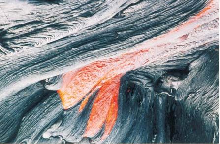
the compound flows (Deshmukh 1988; Mahoney 1988). Such lavas may have had significant yield
strength on account of phenocryst enrichment and may have been emplaced very slowly, though
groundmass crystallinity is also important in deciding yield strength and flow rate (Cashman et al 1999).
The possibility that the abundant plagioclase phenocrysts (and relatively less common olivine and
clinopyroxene phenocrysts) in the lava flows may have grown after emplacement is real, but the
observations indicate otherwise. Deshmukh (1988) described petrographic variations in the Deccan
compound lavas, and described cases where substantial petrographic heterogeneity is seen between lobes,
explaining this with the filtering of liquid leaving phenocrysts behind, settling of phenocrysts, etc. Thus,
the lavas already carried phenocrysts in suspension at eruption. Two large dykes at Dediapada (Sheth et al,
work in progress) are loaded with large (4-5 cm) plagioclase phenocrysts, which also indicates
crystallization of phenocrystic plagioclase at depth.

         Walker (1971) commented on the prolific development of the compound pahoehoe flows in the
Deccan (Figure 7a-g), and wrote that the Ajanta caves in the central Deccan, famous for their religious
sculptures and monuments carved in basalt, ought also to be famous for the magnificent compound flows
themselves. The thick compound flows of the Bushe Formation exposed at Ajanta caves (Figure 7c-e)
expose many individual units and lobes that are the same size as many flow lobes of Kilauea. According
to R. Duraiswami (pers. comm., 2006), the thicker of the lobes show the three-tier internal structure
(upper crust-core-lower crust) typical of inflated flow lobes, and also vesicle cylinders and horizontal
vesicular zones, along with squeeze-ups. Bondre et al (2000) found well-developed inflation features in
thicker flow units around Sangamner, though almost all compound flows that I have examined, in widely
spaced localities (Dhule through Bombay, and much of Saurashtra, e.g., Talala and Rajkot, Figure 5) have
much smaller (Kilauea-size) flow units than the Sangamner ones (see Figure 7). Thicker and larger flow
lobes do exist in many areas, such as Pune, but in any given section, are much fewer in number as
compared to the smaller lobes (N. Bondre, pers. comm., 2006). The local lava discharge rates for all these
lava flows were therefore quite small, of the same order as for the recent and active Kilauea lava flows.

        As Gregg and Keszthelyi (2004) point out, these low discharge rates inferred from the flow lobe
sizes say nothing about the volume that was being erupted per unit time over the whole active flow front
(the bulk eruption rate). The bulk eruption rate for the Deccan lavas must be obtained by integrating the
lava volume along the whole flow front, usually several kilometres long, but as Gregg and Keszthelyi
(2004) note, this is impossible for older flood basalts because of their inherent compound nature. It is not
known, for example, what were the lengths of flow fronts of the Deccan compound flows that were active
at any one time. A bulk eruption rate can be calculated in a direct or indirect manner as shown below, but
whereas the first approach includes some practical difficulties, the second necessarily requires
assumptions and analogy to other flood basalt eruptions.

                                     4. Deriving bulk eruption rates

                               4a. Lava volume divided by eruptive duration

The bulk eruption rate for flood basalts is in principle directly determinable by dividing total erupted
volume by eruptive duration, but in practice this is fraught with difficulties. Extremely high eruption rates
and direct links to mass extinctions have been claimed for flood basalt provinces by workers claiming
extremely short eruptive durations, but the methods and conclusions are highly variable.

         For example, a Re-Os isochron age of 65.6 ± 0.3 Ma (2σ) was presented by Allegre et al (1999)
for Deccan basalts, based on which they argued for an extremely short (0.5 m.y.) eruptive duration
exactly coincident with the K-T boundary. The samples came from lavas with different petrogenetic
histories, spread over an area a thousand km across and various stratigraphic levels, and so the isochron
must be considered quite remarkable. The claimed isochron was shown by Baksi (2001) however to be an

                                                                                                   4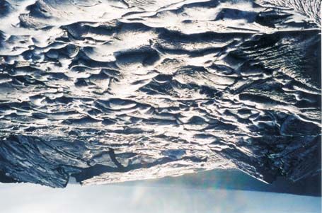
errorchron with an unacceptably high MSWD value of 22, which value was not reported by Allegre et al
(1999). Ar-Ar data are the subject of much dispute, with several workers arguing for a 0.5 m.y. eruptive
duration for the thick Western Ghats sequence (e.g., Hofmann et al 2000) and others for a 4-5 m.y.
duration (e.g., Venkatesan et al 1993; Pande 2002; Pande et al 2004), with Sheth et al (2001a,b) reporting
that the total duration of the volcanism, including late-stage basalts and felsic volcanics, was at least 8-9
m.y. Until this issue gets resolved it is not possible to directly calculate a bulk volumetric eruption rate for
the Western Ghats lava pile, much less the entire province. Note that an average value for the bulk
eruption rate obtained by dividing the total volume by total duration also cannot identify transient peaks
or surges in the eruption rate separated by longer quiet intervals. Field evidence in the Deccan compound
flow sections shows few and only small hiatuses between successive lavas in the Western Ghats, casting
doubt on Pande’s (2002) suggestion that the lavas cover up to six reversed polarity chrons, the in-between
normal chrons not experiencing eruptions. Occasional red beds or boles are present, but again, some of
them do not represent palaeosols but weathered pyroclastic horizons or altered glassy tachylite flows
(Wilkins et al 1994; N. Bondre, pers. comm., 2006).

                    4b. Plagioclase growth rates and “one-dimensional” eruption rate

         Sen (2001) suggested that the growth times of large (up to 5 cm) plagioclase crystals found in the
so-called “giant plagioclase basalt” (GPB) flows found in the Deccan could be used in an indirect manner
to calculate the eruptive duration and eruption rate for the lava pile. His premise was that the plagioclase
formation times determined for the Makaopuhi lava lake in Hawaii could be more or less directly applied
to plagioclase phenocrysts in the GPB flows. By noting that a 10-cm-long plagioclase crystal would take
3,200 yr to form, Sen (2001) calculated the time period represented by six GPB flows in the Western
Ghats stratigraphy to be 6 x 3,200 = 19,200 yr. Then, assuming a thickness of 100 m of each GPB, and
dividing the 600 m total thickness of the six GPBs by 19,200 yr, he derived a “one-dimensional” eruption
rate for the lava pile, of 0.031 m/yr. Ultimately, he divided the 1700 m thickness of the Western Ghats
lava pile by this one-dimensional eruption rate and obtained an eruptive duration of only ~55 kyr for the
entire Western Ghats lava pile, a figure one-tenth that proposed by even the most ardent rapid-volcanism
proponents such as Hofmann et al (2000).

         Sheth (2002), in a comment on Sen’s (2001) approach, called reasonable Sen’s (2001) starting
premise that the Makaopuhi plagioclase growth times may be a guide to the GPB phenocryst plagiclases.
But Sheth (2002) noted that eruption rate is lava volume emitted per unit time and a one-dimensional
eruption rate as calculated by Sen (2001) was meaningless. How is the thickness of a GPB flow, measured
in a vertical section through the lava pile, related to the time its plagioclase phenocrysts took to form in a
magma chamber? In a reply, Sen (2002) agreed that eruption rate is typically expressed in terms of
volume per time, but explained that the lack of knowledge of volumes of individual lava flows is what led
him to derive and use a one-dimensional eruption rate.

        Surprisingly, Sen et al (2006) have attempted to calculate indirectly the formation time of the
Western Ghats lava pile, based on the same flawed approach. From the theoretically estimated formation
times of plagioclase crystals in GPB flows that separate the lower stratigraphic formations, they calculate
the durations of time required to form the Jawhar and Igatpuri Formations as ~1,500 yr. These formations
are ~225 and ~150 m thick, so, they argue, the one-dimensional eruption rates were 0.15 and 0.10 m/yr.
Using these, they derive a new estimate of the formation time of the Western Ghats sequence as only 22.8
kyr. They cite the original paper by Sen (2001), but not the comment on it by Sheth (2002) which noted
the unsound logic of the original calculation. Equally questionable is their assumption that every GPB
flow, and all the lava flows in the formation which that GPB caps, represent eruptions from one magma
chamber. Such a scenario is theoretically unlikely, and increasingly difficult to defend as data accumulate
on dykes and probable feeder dykes in the province (Vanderkluysen et al 2004; Bondre et al 2006).

                                                                                                     5
4c. A calculation based on analogy to other fissure eruptions

Thordarson and Self (1998) and Self et al (1997) calculated an eruption rate of 4000 m3/s for the huge
Roza Member of the Columbia River flood basalt province, using a total emplacement time of 10 years,
and an exposed linear eruptive vent-fissure system 150 km long. This rate is the same as the peak eruption
rate of the 1783-84 Laki eruption in Iceland, world’s largest historic eruption that had severe
environmental effects. As noted, large compound flows in the Deccan are 1000 km3, possibly much larger,
though how much larger cannot be answered because of lack of systematic mapping of individual flow
fields.

         Two major oriented mafic dyke swarms are also recognized in the province, one trending ENE-
WSW along roughly the middle of the subcontinent and the other NNW-SSE along the western rifted
margin, with a third important group of dykes along the Western Ghats (Figure 5; Bondre et al 2006; Ray
et al 2006). The largest known dyke in the province runs ~E-W just north of Dhule for 79 km, and most
other large dykes in the province, in this region, as also in central Saurashtra (Figure 5), are 40-50 km
long. These dykes are exposed today within vast compound lava flows made of thousands of Kilauea-type
small flow units, and in all likelihood fed lava flows at higher levels, now lost to erosion. If so, and if the
eruption rates for the lava flows were only of the order of 1 m3/s per metre of feeder dyke length (the
typical Kilauea eruption rate, Self et al 1997), then a 5-km-long segment of a feeder dyke, active at any
one time, would have erupted 5000 m3/s of lava, or 105 km3 over eight months (individual segments in
the 27-km-long Laki fissure remained active one after the other over several months). Then eruptive
activity could shift to another 5-km-long segment by lateral magma migration, and thus the 50-km-long
fissure would produce 1050 km3 of lava over 80 months, or 6.66 years (Ray et al 2006). This is quite
comparable to the figures for the Columbia River basalts obtained by Self et al (1997) or Petcovic and
Dufek (2005) and, notably, the total eruption rate involved per metre length of fissure (1 m3/s) is no
greater than that for modern Kilauea eruptions. It should be clear that the small size of the constituent
flow units in the large Deccan compound flows is indicative of low local discharge rates, whereas the
bulk eruption rates depend on the length of the active flow front, and these are difficult to know.

        The above calculation is, of course, purely hypothetical (though realistic). Perhaps the bulk
eruption rate for the Deccan, or at least the voluminous and thick Western Ghats sequence, will only be
available once single flows or flow fields are systematically mapped, and the flows, flow fields or flow
sequences dated at high resolution. The key point however is that the local discharge rates were small for
the lower half of the entire Western Ghats stratigraphy, and over half the geographic area of the province,
and these lavas were emplaced in a gentle, effusive, Kilauea-like fashion from regional fissures.

         Note that I do not consider here the “simple” flows of the province (Figure 7h), many of which
seem to run for several kilometres without any lateral discontinuities or terminations, i.e., no constituent
flow units, and usually have prominent columnar jointing (e.g., Sengupta and Ray 2006). These flows,
Bondre et al (2004a) remark, are unlike the simple Columbia River flows that Self et al (1997) find are
merely very large and long lobes of pahoehoe flows that terminate against each other when followed a
few kilometres. For example, Bondre et al (2004a) mention a simple lava flow near Pune that can be
traced continuously for 80 km without any lateral variation in thickness. More recent work (N. Bondre,
unpubl. data, per. comm., 2006) does show, however, pinching and swelling of the “simple” flows along
strike and laterally juxtaposed flow units, though the units themselves are very extensive and thick. Such
flows may indeed have formed at high eruption rates. The Deccan, as other flood basalts, shows
significant morphological differences in its constituent lava flows that demand significantly different
emplacement mechanisms and thereby the likely environmental impacts. Comparative studies worldwide
are essential, though any generalization (not only intra-province, but also inter-province) is dangerous.

                        5. A note on some misconceptions in Deccan volcanology

                                                                                                     6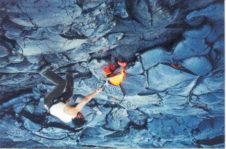
Whereas the growing interest in Deccan volcanology is a good sign, the enthusiast must beware
the misconceptions and misinformation that abounds in some previous Deccan volcanology literature.
This literature is misinformed and misleading, the authors not having had direct experience of active
volcanism or grasped the abundant literature by workers studying active volcano areas.

        For example, some workers (e.g., Raja Rao 1984) have equated aa flows to “simple” flows, and
pahoehoe flows have been equated by some to compound flows. But aa and simple flows are very
different things. The simple flows are thick, extensive sheets that are usually columnar-jointed
(sometimes with multiple tiers) and maintain constant thickness over considerable distances. The aa flows
are clinkery and have thick cores, and are also usually compound like pahoehoe flows, though less
commonly so than pahoehoe, as Walker (1971) noted decades ago. “Simple” flows are not common on
Kilauea and the older Hawaiian volcanoes, whereas aa is very common on them, owing in part to steeper
volcano slopes. Raja Rao (1984) also used the incomprehensible term “simple pahoehoe”.

         The aa flows have rough surfaces, in contrast to the smooth pahoehoe flows. Consider a statement
by Misra (2002, p. 117), however: “The compound (pahoehoe) flows are characterized by clinkery nature,
baking and induration effects, ropy and bun-shaped structures, lava toes, squeeze ups...”. Clinkery is
precisely the word that is applied by workers to aa, not pahoehoe. In the same paper, Misra (2002)
claimed a large number of lava channels and lava tubes in the Deccan based on field work and study of
satellite images. Some of his examples of lava channels do strongly resemble active lava channels in
Hawaii and he is in all probability correct about them, though his quoted widths of 300 m for the lava
channels seem excessive. He also identified lava tubes as much as 100 m wide, from the sinuous
distribution pattern of disconnected, residual hills of the basalts, as around Songir north of Dhule. This
claim was questioned by Dole et al (2002), and by Duraiswami et al (2005) who provided detailed
sketches of the morphology and internal structure of these lava flows. A possible lava tube was reported
by Duraiswami et al (2004) from Daund, near Pune.

         There have been claims that some of the lava flows in the Deccan province are not Deccan but
Quaternary in age. Karmarkar et al (1993) noted volcanic ash beds of Quaternary age exposed near Pune
and in the Narmada region of the Deccan province. The ash may well have been derived from halfway
across the globe, rather than represent local activity. Karmarkar et al (1993) reported a Quaternary
“volcanic breccia” near Ahmednagar, the breccia following the slope carved out of the underlying Deccan
lavas by a recent stream. Based on their descriptions and field sketches, the “volcanic breccia” is probably
a debris-slide or debris-flow deposit and that this follows the slope of the ground would not be surprising.
They also reported field examples from other areas that in their opinion suggest recent volcanic activity.
Thus, they reported lava flows and toes with ropes that appear to have emanated from cracks along the
banks of streams, of recent age, and flowed towards or along the stream beds. As noted earlier in this
paper, the direction of movement of a small lava lobe in a compound lava flow can be at any angle to the
direction of movement of the lava flow as a whole, and ropes on a lava lobe give a flow direction that is
purely local. In any case, the observations of Karmarkar et al (1993) can be explained well by
exhumation-related relief. The lava lobes are not controlled by, or have flowed along, modern or recent
streams; rather, the erosional exhumation is faithfully bringing out the original topography of the lava
flow surfaces (N. Bondre, pers. comm., 2006). That this has happened in the Deccan is well seen in the
examples of the tumuli-rich flows reported by Duraiswami et al (2001,2002). Erosional exhumation has
faithfully re-created the original hummocky surface morphology of these flows.

                                   6. A note on environmental impact

A note is in order on the environmental/atmospheric effects of the Deccan volcanic episode. As Self et al
(1997) note, though flood basalts emit large amounts of CO2 into the atmosphere, the quantities are small

                                                                                                  7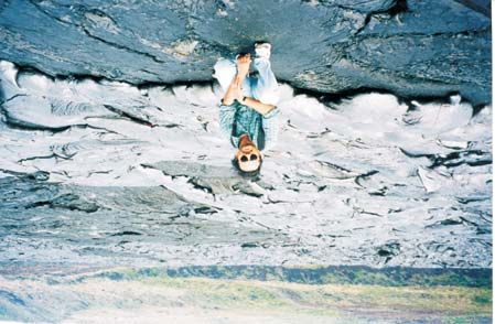
compared to the atmospheric CO2 inventory. On the other hand, flood basalt eruptions can have major
climatic (and thereby biotic) impact if volcanic SO2 and H2S can be pumped high enough into the
atmosphere (stratospheric levels) to be transported as sulphur aerosols around the Earth.

         Noting the major detrimental effects on the environment of the historic (1783-84) Laki fissure
eruption in Iceland, Earth’s largest historic eruption (Thordarson and Self 2003), it is no surprise that
flood basalt provinces of the past have been suggested to have been directly instrumental in the mass
extinctions (e.g., Self et al 2005). Such flood basalts comprise hundreds of eruptions vastly larger than the
Laki eruption. For fissure eruptions, volcanic gases reach a height in the atmosphere controlled by the
mass eruption rate per unit length of fissure, the volatile content of the magma, and the atmospheric
moisture content. Importantly, the Laki eruption could wreak havoc on the environment because of the
high latitude of Iceland, at which the tropopause is low (10 km), and therefore the eruption was able to
inject gases into the stratosphere. The Deccan eruptions 65 m.y. ago occurred at 30o S latitude, over
which the stratosphere would have been ~14 km above the surface.

         The important question therefore is, what was the emplacement of the Deccan flood basalts like?
The answer to this question can be found in the morphology and architecture of the Deccan lava pile itself.
Clearly, much of the Deccan lava pile spread out on the surface at low eruption/discharge rates, which led
to the formation of small flow units. Their biotic and atmospheric impact would depend, of course, on
their eruption rate (volume emitted per unit of time), mode of emplacement (laminar vs. turbulent) and
concentrations of volatile elements such as sulphur contained in them. For the latter, no direct
measurements exist. However, Self et al (2005) suggest that the Deccan eruptions could have been a
major detriment to the environment at that time. The use of the chemical ratio TiO2/FeO (advocated by
Self et al 2005) to infer pre-magmatic sulphur contents for the Deccan flood basalts of the Western Ghats
(624 samples, Sheth 2005) yields high values of 1,073 to 2,333 ppm (Figure 8). However, direct
measurements on glassy selvages and phenocrysts are much preferable to such indirect means. Fresh glass
is hard to find in the Deccan basalts, owing to widespread alteration through 65 m.y., but measurements
on melt inclusions in any unaltered phenocrysts will help to unambiguously establish the pre-degassing
magmatic volatile contents of the Deccan magmas, and how much may have been released into the
atmosphere by them.

         Venkatesan et al (1993) and more recently Pande (2002) and Pande et al (2004) have been
arguing that the lower part (notably dominated by the compound pahoehoe flows) of the 3-km-thick
Western Ghats lava pile significantly preceded the K-T extinctions. If so, this would be consistent with
the morphology and emplacement mechanisms of the lavas. The extinctions were delayed until the
emplacement of the compound flows was over, though these may have stressed the environment to a
degree. It was then the Chixculub bolide impact in Yucatan, Mexico and the extensive “simple” lava
flows of the Deccan with high volumetric eruption rates, making up the upper stratigraphic levels of the
Western Ghats and a large area of the Deccan province, that had the catastrophic atmospheric-biotic
effects.

                                              7. Conclusions

The compound pahoehoe lava flows of the Deccan Traps, however large, would have formed in a very
similar fashion to the modern-day Kilauea volcano lavas in Hawaii. Differences of opinion exist whether
flood basalt lava flows of the past are simply enlarged analogues of modern inflated Hawaiian flows (see
Self et al 1997 and Anderson et al 1999), but this debate, as Bondre et al (2004a,b) rightly note, has been
based largely on observations from and arguments for the Columbia River flood basalts as representatives
of all flood basalts. Even for the Columbia River basalts, Reidel (1998) proposed that the inflation model
of Self et al (1997) was valid for the flow margins, whereas the main portions of the flows were emplaced
by fast laminar flow, not turbulent flow. It is clear that even individual provinces have a great variety of

                                                                                                   8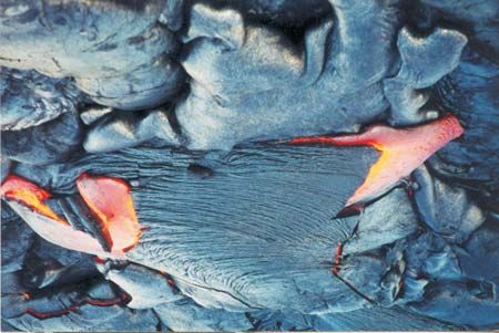
lava morphology and emplacement modes and any generalizations are dangerous. I point out that, while it
may be debatable whether the large flood basalt flows are highly scaled-up versions of the inflated
Hawaiian flows, the key point is that no scaling-up is necessary for all flood basalts. Field data require
that the emplacement of the entire lower half of the Deccan flood basalts was no more catastrophic than
the quiet, effusive Kilauea lava flows of today. The Kilauea lavas are thus direct analogues of half of the
Deccan lavas, though the Columbia River flood basalts are quite different from both in morphology and
emplacement.

         Large (≥1000 km3) Deccan compound flows could have formed even at low local volumetric
eruption rates identical with those of Kilauea, over time scales of only decades or less, from long (40-50
km) fissure systems, and observations of Kilauea’s active lava flows can be usefully extended to these
voluminous and extensive lavas. Systematic future volcanological studies of the older, sufficiently-well-
preserved basaltic lava packages in older rock sequences of the Indian subcontinent (see references in
Sheth and Pande 2004) e.g., the Malani province (Sharma 2004; Singh and Vallinayagam 2004), the
Dongargarh sequence (Sensarma et al 2004), ophiolitic basalts in the Himalaya and the Andaman Islands
(e.g., Srivastava et al 2004), as well as India’s active volcano Barren Island in the Bay of Bengal (Alam et
al 2004) should be of considerable interest.

                                           Acknowledgements

I thank the University of Hawaii for the award of a SOEST Young Investigator (Assistant Researcher)
position that enabled me to experience the magnificent volcanic geology and mesmerizing beauty of the
Hawaiian islands during much of 2001-02 and during a previous visit in August 2000. Stephen Self,
Watson Varricatt, Smitha Jose, Jyotiranjan Ray, Debabrata Banerjee, and Vijay and Daneshwari Sheth
provided company, guidance and help on the Big Island and Kilauea on various occasions. I thank the
many colleagues and co-workers whose company I have had during field work in the Deccan over the
years, and Stephen Reidel, Ninad Bondre, and Raymond Duraiswami for constructive reviews of the
manuscript.

                                                                                                  9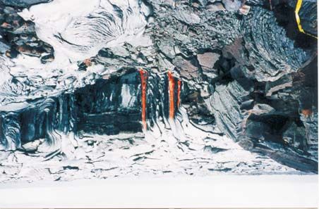
References

Alam M A, Chandrasekharam D, Vaselli O, Capaccioni B, Manetti P and Santo P B 2004 Petrology of
        the prehistoric lavas and dyke of the Barren Island, Andaman Sea, Indian Ocean. In: Magmatism
        in India through Time (eds) H C Sheth and K Pande; Proc. Ind. Acad. Sci. (Earth Planet. Sci.)
        113 pp 715-722
Allegre C J, Birck J L, Capmas F and Courtillot V 1999 Age of the Deccan Traps using 187Re-187Os
        systematics; Earth Planet. Sci. Lett. 170 199-204
Anderson S W, Stofan E R, Smrekar S E, Guest J E and Wood W 1999 Pulsed inflation of pahoehoe lava
        flows: Implications for flood basalt emplacement; Earth Planet. Sci. Lett. 168 7-18
Baksi A K 2001 Misuse of radiometric data: The critical role of simple statistical tests. Global Wrench
        Tectonics Workshop, Bergen (www.earthevolution.org)
Bondre N R, Duraiswami R A, Dole G, Phadnis V M and Kale V S 2000 Inflated pahoehoe lavas from
        the Sangamner area of the western Deccan volcanic province; Curr. Sci. 78 1004-1007
Bondre N R, Duraiswami R A and Dole G 2004a Morphology and emplacement of flows from the
        Deccan volcanic province, India; Bull. Volcanol. 66 29-45
Bondre N R, Duraiswami R A and Dole G 2004b A brief comparison of lava flows from the Deccan
        volcanic province and the Columbia-Oregon Plateau flood basalts: Implications for models of
        flood basalt emplacement. In: Magmatism in India through Time (eds) H C Sheth and K Pande;
        Proc. Ind. Acad. Sci. (Earth Planet. Sci.) 113 pp 809-817
Bondre N R, Hart W K and Sheth H C 2006 Geology and geochemistry of the Sangamner mafic dyke
        swarm, western Deccan volcanic province, India: Implications for regional stratigraphy; J. Geol.
        114 155-170
Cashman K, Pinkerton H and Stephenson J (eds) 1998 Introduction to special section: Long lava flows; J.
        Geophys. Res. 113 27281-27289
Cashman K V, Thornber C and Kauahikaua J P 1999 Cooling and crystallization of lava in open channels,
        and the transition of pahoehoe lava to aa; Bull Volcanol 61 306-323
Decker R and Decker B 2001 Volcanoes in America’s National Parks. Airphoto Intl. Ltd., 256 pp
Deshmukh S S 1988 Petrographic variations in the compound flows in Deccan Traps and their
        significance. In: Deccan Flood Basalts (ed) K V Subbarao; Mem. Geol. Soc. Ind. 10 pp 305-319
Dole G, Bondre N, Duraiswami R A and Kale V S 2002 Discussion on “Arterial system of lava tubes and
        channels within Deccan volcanics of western India” by K S Misra; J. Geol. Soc. Ind. 60 597-599
Duraiswami R A, Bondre N R, Dole G, Phadnis V M and Kale V S 2001 Tumuli and associated features
        from the western Deccan volcanic province, India; Bull. Volcanol. 63, 435-442
Duraiswami R A, Bondre N R, Dole G and Phadnis V M 2002 Morphology and structure of flow-lobe
        tumuli from the western Deccan volcanic province, India; J. Geol. Soc. Ind. 60 57-65
Duraiswami R A, Dole G and Bondre N R 2003 Slabby pahoehoe from the western Deccan volcanic
        province: Evidence for incipient pahoehoe-aa transitions; J. Volcanol. Geotherm. Res. 121 195-
        217
Duraiswami R A, Bondre N R and Dole G 2004 Possible lava tube system in a hummocky lava flow at
        Daund, western Deccan volcanic province, India. In: Magmatism in India through Time (eds) H C
        Sheth and K Pande; Proc. Ind. Acad. Sci. (Earth Planet. Sci.) 113 pp 819-830
Duraiswami R A, Bondre N R and Dole G 2005 The Songir structure: Inflated lava flow or tube? J. Geol.
        Soc. Ind. 65 357-365
Frey F A and Rhodes J M 1993 Intershield geochemical differences among Hawaiian volcanoes:
        Implications for source compositions, melting process and magma ascent paths; Phil. Trans. R.
        Soc. Lond. A342 121-136
Gregg T K P and Keszthelyi L P 2004 The emplacement of pahoehoe toes: Field observations and
        comparison to laboratory simulations; Bull. Volcanol. 66 381-391
Hazlett R W and Hyndman D W 1996 Roadside Geology of Hawaii. Mountain Press Publ. Co., Missoula,
        304 pp

                                                                                             10
Hofmann C, Feraud G and Courtillot V 2000 40Ar/39Ar dating of mineral separates and whole rocks from
the Western Ghats lava pile: Further constraints on duration and age of the Deccan Traps; Earth
Planet. Sci. Lett. 180 13-27
Hon K, Kauahikaua J, Denlinger R, Mackay K 1994 Emplacement and inflation of pahoehoe sheet flows:
Observations and measurements of active lava flows on Kilauea volcano, Hawaii; Geol. Soc. Am.
Bull. 106 351-370
Jerram D A 2002 Volcanology and facies architecture of flood basalts. In: Volcanic Rifted Margins (eds)
M A Menzies, S L Klemperer, C J Ebinger and J Baker; Geol. Soc. Am. Spec. Pap. 362, pp 121-
135
Karmarkar B M, Kulkarni S R, Marathe S S 1993 Quaternary volcanic activity in Deccan plateau; Curr.
Sci. 64 923-925
Kauahikaua J, Cashman C V, Mattox T N, Heliker C C, Hon K A, Mangan M T and Thornber C R 1998
Observations on basaltic lava streams in tubes from Kilauea volcano, island of Hawaii; J.
Geophys. Res. 103 27303-27323
Kerr A C 2005 Oceanic LIPs: The kiss of death; Elements 1, 289-292
Keszthelyi S and Self S 1998 Some physical requirements for the emplacement of long basaltic flows; J.
Geophys. Res. 103 27447-27464
Keszthelyi L, Self S and Thordarson Th 1999 Application of recent studies on the emplacement of
basaltic lava flows to the Deccan Traps. In: Deccan Volcanic Province (ed) K V Subbarao; Mem.
Geol. Soc. Ind. 43 pp 485-520
McLean D M 1985 Deccan Traps mantle degassing in the terminal Cretaceous marine extinctions; Cret.
Res. 6 235-259
Macdonald G A, Abbott A T and Peterson F L 1983 Volcanoes in the Sea: The Geology of Hawaii. 2nd
Edn. University of Hawaii Press, Honolulu. 517 pp
Mahoney J J 1988 Deccan Traps. In: Continental Flood Basalts (ed) J D Macdougall; pp. 151-194.
Kluwer Acad. Publ., Dordrecht
Misra K S 2002 Arterial system of lava tubes and channels in Deccan volcanics of western India; J. Geol.
Soc. Ind. 59 115-124
Pande K 2002 Age and duration of the Deccan Traps, India: A review of radiometric and palaeomagnetic
constraints; Proc. Ind. Acad. Sci. (Earth Planet. Sci.) 111 115-123
Pande K, Pattanayak S K, Subbarao K V, Navaneethakrishnan P and Venkatesan T R 2004 40Ar-39Ar age
of a lava flow from the Bhimashankar Formation, Giravli Ghat, Deccan Traps. In: Magmatism in
India through Time (eds) H C Sheth and K Pande; Proc. Ind. Acad. Sci. (Earth Planet. Sci.) 113
pp 755-758
Petcovic H L and Dufek J D 2005 Modelling magma flow and cooling in dykes: Implications for
emplacement of Columbia River flood basalts; J. Geophys. Res. 110
B10201:doi:10.1029/2004JB003432
Raja Rao C S 1984 The geological control for formation of laterite in western Maharashtra. In: Proc.
Symp. On Deccan Trap and Bauxite (eds) B Prasad and B S Manjrekar; Geol. Surv. Ind. Spec.
Publ. 14 pp 262-265
Ray R, Sheth HC, Mallik J 2006 Structure and emplacement of the Nandurbar-Dhule mafic dyke swarm,
Deccan Traps, and the tectonomagmatic evolution of flood basalts; Bull. Volcanol. (in press)
Reidel S P 1998 Emplacement of Columbia River flood basalt; J. Geophys. Res. 103 27393-27410
Self S, Thordarson Th and Keszthelyi L 1997 Emplacement of continental flood basalt lava flows. In:
Large Igneous Provinces: Continental, Oceanic, and Planetary Flood Volcanism (eds) J J
Mahoney and M F Coffin; Am. Geophys. Union Geophys. Monogr. 100 pp 381-410
Self S, Thordarson Th and Widdowson M 2005 Gas fluxes from flood basalt eruptions; Elements 1 283-
287
Sen G 2001 Generation of Deccan Trap magmas; Proc. Ind. Acad. Sci. (Earth Planet. Sci.) 110 409-431
Sen G 2002 Giant plagioclase basalts, eruption rate versus time: Response to Sheth’s comments and some
additional thoughts; Proc. Ind. Acad. Sci. (Earth Planet. Sci.) 111 487-488
11Sen G, Borges M and Marsh B D 2006 A case for short duration of Deccan Trap eruption; Eos 87 197
Sengupta P and Ray A 2006 Primary volcanic structures from a type section of Deccan Trap flows around
Narsingpur-Harrai-Amarwara, central India: Implications for cooling history; J. Earth Syst. Sci.
(in press)
Sensarma S, Hoernes S and Mukhopadhyay D 2004 Relative contributions of crust and mantle to the
origin of the Bijli Rhyolite in a Palaeoproterozoic bimodal volcanic sequence (Dongargarh
Group), central India. In: Magmatism in India through Time (eds) H C Sheth and K Pande; Proc.
Ind. Acad. Sci. (Earth Planet. Sci.) 113 pp 619-648
Sharma K K 2004 The Neoproterozoic Malani magmatism of the northwestern Indian shield: Implications
for crust-building processes. In: Magmatism in India through Time (eds) H C Sheth and K Pande;
Proc. Ind. Acad. Sci. (Earth Planet. Sci.) 113 pp 795-808
Sheth H C 2002 Comments on “Generation of Deccan Trap magmas” by Gautam Sen; Proc. Ind. Acad.
Sci. (Earth Planet. Sci.) 111 483-485
Sheth H C 2003 The active lava flows of Kilauea volcano, Hawaii; Resonance (J. Sci. Edu.) 8 24-33
Sheth H C 2005 Were the Deccan flood basalts derived in part from ancient oceanic crust within the
Indian continental lithosphere? Gond. Res. 8 109-127
Sheth H C 2006 “Large Igneous Provinces (LIPs)”: Definition, recommended terminology, and a
hierarchical classification; J. Volcanol. Geotherm. Res. (in press)
Sheth H C and Pande K (eds), 2004. Magmatism in India through Time. Proc. Ind. Acad. Sci. (Earth
Planet. Sci.) 113, 517-838 (www.ias.ac.in/epsci/contdec2004.html)
Sheth H C, Pande K and Bhutani R 2001a 40Ar-39Ar ages of Bombay trachytes: Evidence for a Palaeocene
phase of Deccan volcanism; Geophys. Res. Lett. 28 3513-3516
Sheth H C, Pande K and Bhutani R 2001b 40Ar-39Ar dating of a national geological monument: The
Gilbert Hill basalt, Bombay, Deccan Traps; Curr. Sci. 80 1437-1440
Sheth H C, Mathew G, Pande K, Mallick S and Jena B 2004 Cones and craters on Mount Pavagadh,
Deccan Traps: Rootless cones? In: Magmatism in India through Time (eds) H C Sheth and K
Pande; Proc. Ind. Acad. Sci. (Earth Planet. Sci.) 113 pp 831-838
Singh A K and Vallinayagam G 2004 Geochemistry and petrogenesis of anorogenic basic volcanic-
plutonic rocks of the Kundal area, Malani igneous suite, Rajasthan, India. In: Magmatism in India
through Time (eds) H C Sheth and K Pande; Proc. Ind. Acad. Sci. (Earth Planet. Sci.) 113 pp
667-682
Srivastava R K, Chandra R and Shastry A 2004 High-Ti type N-MORB parentage of basalts from the
south Andaman ophiolite suite, India. In: Magmatism in India through Time (eds) H C Sheth and
K Pande; Proc. Ind. Acad. Sci. (Earth Planet. Sci.) 113 pp 605-618
TenBruggencate J 2000 Hawaii: Land of Volcanoes. Mutual Publ., 102 pp
Thordarson Th and Self S 1998 The Roza Member, Columbia River Basalt Group: A gigantic pahoehoe
lava flow field formed by endogenous processes? J. Geophys. Res. 103 27411-27445
Thordarson Th and Self S 2003 Atmospheric and environmental effects of the 1783-84 Laki eruption: A
review and reassessment; J. Geophys. Res. 108 (D1): 4011
Venkatesan T K, Pande K and Gopalan K 1993 Did Deccan volcanism pre-date the Cretaceous/Tertiary
transition? Earth Planet. Sci. Lett. 119 181-189
Walker G P L 1971 Compound and simple lava flows and flood basalts. In: Deccan Trap and Other
Flood Eruptions, Part I (ed) U Aswathanarayana; Bull. Volcanol. 35 579-590
Waichel B L, de Lima E F, Lubachevsky R and Sommer C A 2006 Pahoehoe flows from the central
Parana continental flood basalts; Bull. Volcanol. 176 599-610
Wignall P B 2005 The link between large igneous province eruptions and mass extinctions; Elements 1,
293-297
Wilkins A, Subbarao K V, Ingram G and Walsh J N 1994 Weathering regimes within the Deccan basalts.
In: Volcanism (ed) K V Subbarao, pp 217-232. Wiley, New Delhi.
12Figure captions
Figure 1. Simplified map of the Hawaiian islands. Dark triangles are the major volcanoes, of which
Kilauea, Mauna Loa and Loihi seamount (below sea level) are currently active. Based on Frey and
Rhodes (1993). Rectangular box over Kilauea shows the area of current and recent volcanic activity, from
where the photographs in Figures 2 to 4 come.
Figure 2. Snapshots of growing lava lobes on Kilauea volcano. Photos by HCS, May 2002. (a) A fresh,
0.5-metre-wide pahoehoe lava lobe that is only a few seconds old. Note how the colour of the lava
progressively changes along the lobe’s length. The front has come to rest and cooled sufficiently to look
dark grey, while completely liquid lava (yellow to orange) is following at the rear. Ropes have begun to
develop in the frontal part and will be propagated within seconds to the rear portions of the lobe. Note
also the yellow lava oozing out of the sides of this lobe, to both right and left. The lobe swelled for a
while before bursting along the sides. New lobes will have formed in less than a minute. This is how
many of the huge Deccan Trap lava flows of India may have been emplaced – nice and slow. (b) Another,
similar small active lobe in close-up, nicely showing the colour changes with cooling, ropes, and new
breakouts forming.
Figure 3. Snapshots of active lava flows erupted from the Pu’u’ O’o’ vent on Kilauea volcano, taken near
the ocean entry. (a) Lava entering the ocean. Streams of yellow-hot lava are seen in the lower right
distance, about 100 m away. Note the huge steam plume due to the heat of the lava, and the Pacific ocean
in the background. Sulphur dioxide (SO2) and other toxic gases contained in the lava mix with the water,
forming sulphuric acid and other chemicals. March 2002. (b) Breakouts from the right and left of a lobe
with a ropy crust. Width of the lobe is ~2 m. May 2002. (c) Another active pahoehoe lava lobe only 2 m
away, flowing toward the right, with ropy structure developing nicely. Note the newer, small breakout
lobe or toe emerging from the base of this lobe towards the camera. May 2002. (d) It is not for nothing
that Kilauea has the reputation of being the safest volcano on Earth. Here, HCS breaks open the solidified
crust over an active lava flow with a rock hammer, exposing yellow-hot lava (1200 oC) within, which will
pour out and cool in turn. Note the architecture of the flow and the small sizes of the individual lobes.
May 2002. (e) to (h) Activity about 200 m inland of the ocean, July 2002. In (e) Lava emerges through
the roof of an underlying crusted-over lava tube and flows into a pit, as HCS looks on. Each lava ‘spring’
is ~0.5 m wide. Note the ropes in some of the lobes that formed only a few minutes ago, and the
compound character and the flatness of the sheet flow itself. (f) Lava streams emerge through the roof of
a lava tube, only to fall into the pit. Each stream is ~0.5 m wide. With decreased velocity and lava volume,
the activity would resemble hot wax dripping from a candle (see Sheth 2003). (g) Close-up of the lava
springs, each ~0.5 m wide. Note how convex-outward ropes are forming in the one to the right. (h) Only
~20 m from this pit, HCS poses in front of small lobes and toes emplaced only a few minutes ago. These
are not frozen, but inflating, deforming and moving very slowly at the moment, and small chips are
spalling off them producing a crackling sound. View is roughly due north. The steep face in the distance
is a normal fault. Photos (a), (b), (c), (f), (g) by HCS; (d) by Jyotiranjan Ray; (e) and (h) by Vijay Sheth.
Figure 4. Features of recent, no longer active, compound pahoehoe flows on Kilauea, near the ocean entry.
Lavas are from both Pu’u’ O’o’ vent and the Mauna Ulu vent, active 1969-74. (a) HCS on a large,
prominent tumulus with an axial cleft. (b) HCS stands on another large, broad and low (“whaleback”)
tumulus with characteristic fissures on its top surface. (c) Typical appearance of a Kilauea pahoehoe flow.
Note the complex compound nature, and the general flatness broken by the two tumuli, one to the left and
another on the right. The sizes of these tumuli are similar to the ones in (a) and (b) above. (d) A section
through compound lava flows exposed in the walls of a pit crater on Kilauea. The individual flow units
here are somewhat larger than in the previous photographs. (e) Pahoehoe (entrail pahoehoe, silvery grey)
and aa (black, clinkery) in close juxtaposition, with HCS for scale. Both are distinctly different in their
morphology, and yet both are part of the same eruption and the same lava flow (1972 Mauna Ulu lavas,
13locality Alanui Kahiko). The practice followed by some past workers in the Deccan, of identifying and
demarcating different lava packages on the basis of their pahoehoe or aa morphology, is basically flawed.
(f) Ropy structure preserved on the top surface of a pahoehoe lobe. The lobe flowed from right to left.
Hammer is 32 cm long. Photos (a), (b), (d), (e) by Stephen Self, August 2000; photos (c) and (f) by HCS,
March 2002.
Figure 5. Sketch-map of the Deccan flood basalt province showing the localities mentioned in the text, the
regions dominated by compound pahoehoe and simple flows, and the main dyke swarms (thick lines).
Based on Bondre et al (2004a,b, 2006).
Figure 6. Sketches of outcrops and sections through compound pahoehoe flows in the Deccan province,
based on Walker (1971) and Bondre et al ( 2004a).
Figure 7. Some typical scenery developed on the Deccan compound lava flows, and morphology of the
compound flows (see Figure 5 for locations). All photos by HCS, December 2005 and June 2006. (a)
Scenery around Trimbakeshwar (see Figure 6e for a section sketch). Note the steep scarps with general
rounded tops. (b) Scenery around Satana, central Deccan. Note again the scarps and rounded hills. (c)
Flow lobes exposed in a vertical section at Ajanta caves. The lobe size is variable but small overall.
Person for scale. (d) Several small lobes in close vertical and horizontal juxtaposition, Ajanta caves.
Height of view is 1 m. Compare to the sketches of the Deccan compound flows in Figure 6, and photos of
Kilauaea lava lobes in Figures 2-4. (e) Similarly small lobes in juxtaposition. Pen near left-centre is 9 cm
long. (f) A succession of flow lobes exposed on a lava butte near Bhamer village, north of Sakri. A dyke
3-4 m wide is seen cutting the lava flow. (g) Quarry near Talala, southern Saurashtra, exposing a
compound lava flow. Compare the lobe sizes to the other examples. (h) View of the >1-km-thick (~300 m
in the photograph) Mahabaleshwar sequence, dominated by “simple” flows. Considerable thickness
variation and lateral discontinuities are found when the flows are traced along strike, however.
Figure 8. A plot of sulphur content (ppm) vs. the TiO2/FeO ratio for flood basalts, after Self et al (2005).
The diagonal straight line (A) is their best-fit line through the data fields of pre-degassing magmatic
sulphur contents, though not quantified statistically by the authors. Note that no direct measurements of
sulphur contents in the Deccan lavas or melt inclusions in phenocrysts exist. Therefore, the equation of
this line was derived here by simply noting down coordinates of points along it, and based on this
equation, the pre-degassing sulphur contents of the Deccan flood basalts (624 samples, Sheth 2005) were
calculated (at 1,073 to 2,333 ppm) using their TiO2/FeO ratios. The tight correlation of the data (thick line)
is thus purely artificial, but the line is merely intended to convey and compare the pre-magmatic sulphur
contents of the other flood basalts with the calculated ones of the Deccan basalts. The field and line B
represent data on sulphur concentrations in tephra (after vent degassing) for the other flood basalts, and C
represents data obtained on lavas (after flow degassing).
14Kauai o o o
157 156 155
Koolau
HA 100 km
Waianae Honolulu East WA
IIAN
Molokai
West ISL 21o
AN
Molokai West Maui DS
PACIFIC
OCEAN
Lanai Haleakala (East Maui)
Kahoolawe
NORTH
Kohala
Hawaiian
AMERICA
20o
Islands ATLANTIC Mauna Kea
OCEAN Hualalai Hilo
PACIFIC
Mauna Loa Kilauea
OCEAN SOUTH
AMERICA
19o
Loihia b
a b c d e f g h
a   b

c   d

e   f
70o               72o      74o             76o             78o           80o
24o
KACHCHH           regions dominated
                     by compound
                    pahoehoe flows           MALWA                            Jabalpur
                                                                Narsingpur MANDLA
  SA        Rajkot
      UR                           Toranmal
        AS                                                             ly
           HT                                                    inant
              R                                               dom " flows
       Talala A                                                    le
                                   Sakri
                                        Dhule                "simp
                                 Satana        Ajanta
20o                          Trimbak
                                         Ellora DECCAN
                               Igatpuri
                                               VOLCANIC
                             Sangamner         PROVINCE
                Bombay               Ahmednagar
                             Pune
                                                         s

18o        ARABIAN
                                                         w
                                                       flo

             SEA             Mahabaleshwar
                                                    e"
                                                    pl
                            WES

                                                  im

                                                                    INDIA
                                              "s
                                             tly
                             TER

                                             an
                                         in
                                        m

           km
                                        do
                               N GH

16o
  0        100    200
                                  ATS
a e
pipe 1m
vesicles
m
110
vesicles
100
90
crust with vesicle banding b
80
pipe
vesicles 70
1m
60
c
pipe crust with
vesicles vesicle banding
50
vesicles
40
1m
30
d
10 m
20
10
0aa b c d e f g h
Iceland Deccan        A 5
2500                                                        55
                                                        0x+
                          Hawaii                5  68
2000                                         y=
 S                                        Roza
(ppm)        MORB

1000
                             Deccan

 500                                                B
                                                        C
     0
         0          0.1            0.2       0.3             0.4
                              TiO2/FeO
You can also read