A Geologic Field Guide to S P Mountain and its Lava Flow, San Francisco Volcanic Field, Arizona - Open-File Report 2021-1072
←
→
Page content transcription
If your browser does not render page correctly, please read the page content below
A Geologic Field Guide to S P Mountain and its Lava Flow,
San Francisco Volcanic Field, Arizona

Open-File Report 2021–1072

U.S. Department of the Interior
U.S. Geological Survey
Cover. Photograph of S P Mountain, Arizona. Photograph by Amber Gullikson, U.S. Geological Survey.
A Geologic Field Guide to S P Mountain
and its Lava Flow, San Francisco Volcanic
Field, Arizona

By Amber L. Gullikson, M. Elise Rumpf, Lauren A. Edgar, Laszlo P. Keszthelyi,
James A. Skinner, Jr., and Lisa Thompson

Open-File Report 2021–1072

U.S. Department of the Interior
U.S. Geological Survey
U.S. Geological Survey, Reston, Virginia: 2021

For more information on the USGS—the Federal source for science about the Earth, its natural and living resources,
natural hazards, and the environment—visit https://www.usgs.gov or call 1–888–ASK–USGS (1–888–275–8747).
For an overview of USGS information products, including maps, imagery, and publications,
visit https://store.usgs.gov.

Any use of trade, firm, or product names is for descriptive purposes only and does not imply endorsement by the
U.S. Government.

Although this information product, for the most part, is in the public domain, it also may contain copyrighted materials
as noted in the text. Permission to reproduce copyrighted items must be secured from the copyright owner.

Suggested citation:
Gullikson, A.L., Rumpf, M.E., Edgar, L.A., Keszthelyi, L.P., Skinner, J.A., Jr., and Thompson, L., 2021, A geologic field
guide to S P Mountain and its lava flow, San Francisco Volcanic Field, Arizona: U.S. Geological Survey Open-File
Report 2021–1072, 37 p., https://doi.org/10.3133/ofr20211072.

ISSN 2331-1258 (online)
iii

Acknowledgments
We are grateful to Greg Vaughan (USGS) and Mark Salvatore (Northern Arizona University) for
their insightful comments which have greatly improved this report.

Contents
Acknowledgments.........................................................................................................................................iii
Introduction.....................................................................................................................................................1
A Brief Tour of Volcanism Across the Solar System.................................................................................1
      Mercury..........................................................................................................................................................2
      Venus......................................................................................................................................................................... 2
      Earth........................................................................................................................................................................... 2
      The Moon................................................................................................................................................4
      Mars................................................................................................................................................................4
      Meteorites...............................................................................................................................................6
      Io......................................................................................................................................................................7
      Summary of Volcanism in the Solar System......................................................................................7
A Brief Geologic History of the Colorado Plateau and San Francisco Volcanic Field........................8
      The Physiographic Regions of Arizona..............................................................................................8
      Raising the Colorado Plateau..............................................................................................................8
      Rock Ages of the Colorado Plateau Province...................................................................................9
      San Francisco Volcanic Field.............................................................................................................10
      Fault Systems within the San Francisco Volcanic Field................................................................11
      Sources of Volcanic Rock Compositions.........................................................................................12
Distributed Volcanism and Associated Volcanic Features....................................................................12
      Distributed Volcanic Fields and Clusters.........................................................................................12
      Eruption Styles.....................................................................................................................................13
      Lava Flows............................................................................................................................................14
S P Mountain and its Lava Flow.................................................................................................................14
      The Age of S P Mountain....................................................................................................................14
      Dimensions of S P Mountain and General Features......................................................................14
      Dimensions of S P Mountain Lava Flow and General Features...................................................14
      Lava Flow Emplacement Theories....................................................................................................16
      S P Graben............................................................................................................................................16
Getting to S P Mountain...............................................................................................................................17
      Disclaimer.............................................................................................................................................18
Stop 1. Source of the Lava Flow.................................................................................................................18
Stop 2. At the Intersection of the Road and Lava Flow..........................................................................23
Stop 3. Lava Flow..........................................................................................................................................24
Stop 4. The Rim of S P Mountain................................................................................................................27
Stop 5. Graben...............................................................................................................................................31
Questions for Discussion at the End of the Field Trip.............................................................................34
References.....................................................................................................................................................34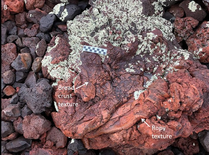
iv
Figures
1. Satellite images of volcanic features on Venus.......................................................................3
2. Photograph of flood lavas in Mare Imbrium as seen from orbit............................................4
3. Satellite image of lunar volcanism.............................................................................................5
4. Satellite image of an aerial view of Olympus Mons ...............................................................5
5. Satellite image of lava flows associated with the Arsia Mons volcanic complex.............5
6. Satellite image of what is presumed to be volcanic cones located in the Coprates
Chasma region of the Valles Marineris canyon system..........................................................6
7. Satellite image of an eroded portion of the Medusae Fossae Formation, a unit thought to
have formed from pyroclastic flows or volcanic ash deposits.....................................................6
8. Photograph of a cumulate eucrite meteorite............................................................................6
9. Satellite image of Amirani (an active volcano on Io) and its flow field................................7
10. Satellite image comparing S P Mountain to a satellite image of a volcano on Mars........7
11. Map of Arizona showing the three main physiographic provinces that compose Arizona.......8
12. Map of the physiographic provinces in Utah, Colorado, Arizona, and New Mexico.........9
13. Geologic block diagram showing the surface and subsurface geology of the
Flagstaff area................................................................................................................................10
14. Digital elevation model of the San Francisco Volcanic Field...............................................11
15. Illustration of the extent of the San Francisco Volcanic Field and its silicic and
intermediate vents, major fault systems, and the northern extent of rim basalts............12
16. Satellite image of the field site..................................................................................................13
17. Photograph of an oblique view of S P Mountain, showing the volcano’s dimensions....14
18. Photographs of lava flow near S P Mountain showing the contrast between surface
texture 1 and 2..............................................................................................................................15
19. Photograph of an agglutinated mound that was transported away from the vent
downstream..................................................................................................................................16
20. Photographs of the S P Mountain lava flow showing the graben and spillover...............17
21. Schematic cross section of a typical tephra cone................................................................17
22. Satellite image of S P Mountain, highlighting the locations of the first four stops of the
guidebook......................................................................................................................................18
23. Photograph of the source of the lava from stop 1..................................................................19
24. Photograph looking north from stop 1......................................................................................19
25. Photograph looking west from stop 1......................................................................................20
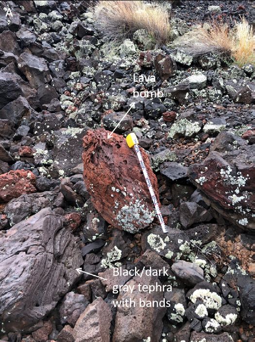
26. Photographs of a lava bomb at stop 1......................................................................................20
27. Photograph looking north toward the lava flow at stop 1.....................................................21
28. Photograph of the lava flow and onlapping tephra at stop 1...............................................21
29. Photographs of two types of tephra at stop 1.........................................................................22
30. Photograph looking south at the contact point between S P Mountain and an older
tephra cone to the west at stop 2.............................................................................................23
31. Looking south at S P Mountain and the source of the lava flow standing on the road
near stop 2....................................................................................................................................23
32. Photograph taken on the vegetated portion of the lava flow at stop 3..............................24
33. Photograph of surface texture 1 at stop 3...............................................................................25
34. Photograph of a blocky and unvegetated lava flow, looking south from stop 3...............25
35. Photographs of the S P Mountain lava flow at stop 3...........................................................26
36. Photographs of polygonal pavement at stop 3.......................................................................26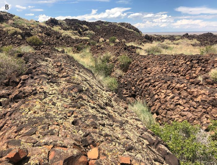
v

   37.   Photograph taken at stop 4 of the rim of S P Mountain looking east.................................27
   38.   Photograph taken at stop 4 from the rim of S P Mountain looking north...........................27
   39.   Photograph of a red agglutinated piece of volcanic rock taken on the rim of S P
         Mountain at stop 4.......................................................................................................................28
   40.   Photograph of smaller lapilli welded onto a lava bomb taken along the rim of S P
         Mountain at stop 4.......................................................................................................................28
   41.   Photograph of compressional bands on a volcanic rock taken along the rim of S P
         Mountain at stop 4.......................................................................................................................28
   42.   Photograph taken at stop 4 looking northwest toward the S P Mountain lava flow........29
   43.   Photograph taken at stop 4 looking northeast........................................................................29
   44.   Photograph taken at stop 4 on the rim of S P Mountain looking southwest.....................30
   45.   Photograph taken at stop 4 on the rim of S P Mountain looking to the south at Colton
         Crater.............................................................................................................................................30
   46.   Satellite image showing how to get to stop 5.........................................................................31
   47.   Photograph taken at stop  5 on the floor of the graben with the S P Mountain lava flow to
         the east..........................................................................................................................................31
   48.   Photographs of agglutinated transported material located within the S P Mountain lava
         flow, taken at one of the lobes that entered the graben.........................................................32
   49.   Photograph at stop 5 between the Kaibab Limestone and the S P Mountain lava flow..........32
   50.   Photograph of the S P Mountain lava flow lobe, taken standing on the Kaibab
         Limestone looking south at stop 5.............................................................................................33
   51.   Photograph of the S P Mountain lava flow on the left side with S P Mountain in the
         background, taken on top of an agglutinated mound transported by the S P Mountain
         lava flow.........................................................................................................................................33

Tables
    1.   Volcanic eruption classification based on erupted volume...................................................2
    2.   Simplified volcanic rock classification based on major minerals and silica content........2
    3.   Particle size classification for volcanic and sedimentary rocks...........................................2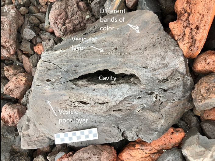
vi

     Conversion Factors
     U.S. customary units to International System of Units

                        Multiply                                By                   To obtain
                                                             Length
      foot (ft)                                              0.3048    meter (m)
      mile (mi)                                              1.609     kilometer (km)

     International System of Units to U.S. customary units

                       Multiply                                 By                   To obtain
                                                             Length
      centimeter (cm)                                        0.3937    inch (in.)
      millimeter (mm)                                        0.03937   inch (in.)
      meter (m)                                              3.281     foot (ft)
      kilometer (km)                                         0.6214    mile (mi)
      kilometer (km)                                         0.5400    mile, nautical (nmi)
      meter (m)                                              1.094     yard (yd)
                                                              Area
      square kilometer (km2)                            247.1          acre
      square kilometer (km ) 2
                                                             0.3861    square mile (mi2)

     Abbreviations
     DEM			                digital elevation model
     GPS			                global positioning system
     HED			                Howardite-eucrite-diogenite
     NASA			               National Aeronautics and Space Administration
     OSL			                Optically stimulated luminescence
     USGS			               U.S. Geological Survey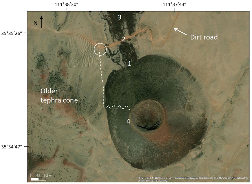
A Geologic Field Guide to S P Mountain and its Lava Flow,
San Francisco Volcanic Field, Arizona
By Amber L. Gullikson,1 M. Elise Rumpf,1 Lauren A. Edgar,1 Lazlo P. Keszthelyi,1 James A. Skinner, Jr.,1
and Lisa Thompson2

Introduction                                                               This guide is outlined as follows:
                                                                           • A brief tour of volcanism across the solar system
      We created this guide to introduce the user to the San
                                                                           • A brief geologic history of the Colorado Plateau and San
Francisco Volcanic Field as a terrestrial analog site for planetary
                                                                             Francisco Volcanic Field
volcanic processes. For decades, the San Francisco Volcanic
Field has been used to teach scientists to recognize the products          • Background on distributed volcanism and S P Mountain
of common types of volcanic eruptions and associated volcanic
features. The volcanic processes and products observed in this             • Driving directions and field stops
volcanic field are like those observed on lunar and Martian                • Questions for discussion
surfaces. As a result, this region has been a favored location for
training National Aeronautics and Space Administration astronauts           Each field stop includes a brief description, learning goals,
and engineers since the Apollo missions.                              tasks, and a summary of key points. At the end of the field
      Though the San Francisco Volcanic Field has more than 600       guide are discussion points and questions that will ask the user
volcanic vents and flows, this guide will focus on S P Mountain       to consider what they have observed and learned and how such
(known locally as S P Crater, located ~30 miles north of Flagstaff,   knowledge can be used to better our understanding of geologic
Arizona), one of the best preserved and most accessible of the        processes on other planetary bodies.
volcanic cones and lava flows. S P Mountain presents both major             Upon the completion of this field guide, we expect the user to:
types of basaltic eruptions—explosive and effusive—as well as               • Have a basic understanding of the volcanic processes
some commonly associated tectonic landforms.                                   relevant to S P Mountain and its lava flow.
      We assume that the user has a basic understanding of
                                                                           • Be able to identify different volcanic textures that are
geologic concepts and terminology. For more specialized
                                                                             associated with tephra cones.
terminology, we include tables showing the classification
scheme for lava compositions, styles of eruptions, and                     • Be aware of the different observations one can make
tephra sizes (tables 1, 2, and 3). If a further introduction or              at different scales (for example, observing lava flow
refresher in volcanological terminology is desired, we suggest               morphology from aerial or satellite imagery versus tephra
reviewing such terms on the U.S. Geological Survey Volcano                   characteristics in the field).
Science Center’s online glossary (https://volcanoes.usgs.gov/
vsc/glossary/).
      One term requires clarification at the start of this guide—
the term cinder. The terms cinder and cinder cone are widely          A Brief Tour of Volcanism Across the
used to describe the material and edifice produced by lava
fountains. However, the term comes from the mining and                Solar System
construction industries and has no clear or formal definition.
The international committees in geology and volcanology                     Volcanism is one of the fundamental geologic processes
have chosen the term tephra to be the general term to describe        that have shaped our solar system and is indicated by the
pyroclasts (material ejected through a volcanic explosion or          prevalence of basalt, a magnesium- and iron-rich volcanic
from a volcanic vent). Therefore, in this guide, we use the           rock, on planetary surfaces (for example, Cattermole, 1989;
                                                                      Hodges and Moore, 1994; Lopes and Gregg, 2004; Gregg and
term tephra rather than cinder.
                                                                      others, 2020). Here, we briefly tour the planets, moons, and
                                                                      asteroids of our solar system that show evidence of volcanism
  1
   U.S. Geological Survey.                                            to have occurred at some time in their history. First, we begin
  2
   Northern Arizona University.                                       with Mercury, the closest planet to the Sun.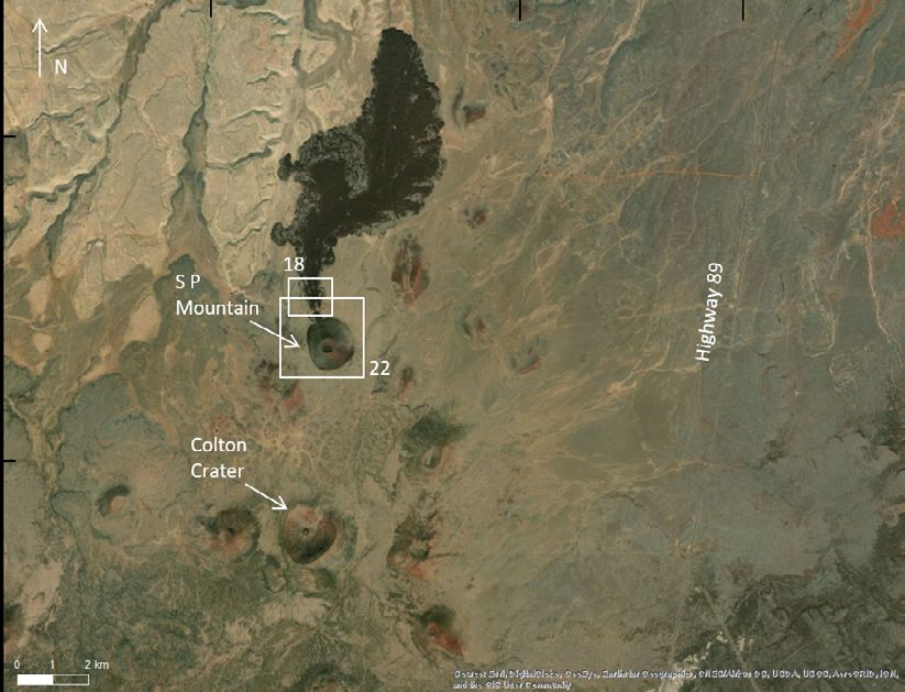
2   A Geologic Field Guide to S P Mountain and its Lava Flow, San Francisco Volcanic Field, Arizona

Table 1. Volcanic eruption classification based on erupted volume.
[Volcanologists have developed many classification schemes for types of volcanic eruptions, but the international standard relies on names derived from a
volcano that best typifies each class of eruption. This classification was made quantitative by Newhall and Self (1982) using the logarithmic volcanic explosivity
index (VEI) presented below. km3, cubic kilometer]

      Name                                                  Description                                               VEI             Erupted volume (km3)
 Hawaiian              Sustained lava fountains that can feed lava flows and build cones of tephra.                   0–1                 64                                                 Bomb                                            Cobble or boulder
                        2–64                                                Lapilli                                         Gravel
A Brief Tour of Volcanism Across the Solar System 3 Figure 1. Satellite images of volcanic features on Venus. A, Perspective view of Maat Mons (a shield volcano located at 0.9 °N, 194.5 °E) with a vertical exaggeration of 10:1. Produced by the Jet Propulsion Lab (JPL) using topography developed by the U.S. Geological Survey (USGS) (image ID PIA00106). B, Cluster of cones (image ID PIA00465). C, Lava flows (radar- bright) extending across the surface of Venus (47 °S, 25 °E). Image is ~550 km east-west by ~630 km north-south (image ID PIA00486). D, Lava domes (pancake domes) on the eastern edge of Alpha Regio (21.9 °N, 325 °E) (image ID PIA00261). E, Canali, black arrows point to this meandering channel (49 °S, 273 °E) (image ID PIA00253). Images by National Aeronautics and Space Administration’s (NASA) Magellan spacecraft and courtesy of NASA/Jet Propulsion Lab at CALTECH (JPL-CALTECH).
4   A Geologic Field Guide to S P Mountain and its Lava Flow, San Francisco Volcanic Field, Arizona

of terrestrial analogs. Overall, environmental changes (such       (fig. 2). Second, pyroclasts are expected to travel farther,
as ambient temperature, gravity, and atmosphere) have only         resulting in more areally expansive and thinner tephra deposits
modest effects on the behavior of basaltic lava flows (for         when compared to Earth (fig 3) (Wilson and Head, 1981).
example, Keszthelyi, 1995; Keszthelyi and others, 2006);
however, Earth’s relatively thick atmosphere does have a
major effect on how volcanic gases can expand and propel           Mars
erupting material (Wilson and Head, 1981).
                                                                        Volcanism on Mars is widespread and has been
                                                                   extensively studied (Carr, 1973; Greeley and Spudis, 1981;
The Moon                                                           Tanaka and others, 2014). The giant shield volcanoes that
                                                                   define the Tharsis Montes and surrounding regions, including
       The nearside of our Moon is riddled with large dark         the 27-km-tall (kilometer) Olympus Mons (the tallest volcano
patches, many of which are basins formed by ancient meteorite      in the solar system), are perhaps the most famous. Although
impacts. These impacts were incredibly large and energetic         Olympus Mons has the same general shape as the largest
and resulted in heavily fractured lunar crust. Magma ascended      volcano on Earth, the Hawaiian shield volcano Mauna Loa, it
along such fractures and erupted basaltic lava onto the surface,   is approximately 100 times more voluminous and covers an
which filled the low-lying impact basins. Additional volcanic      area roughly equivalent to the State of Arizona (fig. 4). The
landforms such as shield volcanoes, tephra deposits, and even      massive volcanoes of Tharsis Montes are covered in thick
silicic domes have also been observed on the lunar surface         lava flows and are surrounded by vast plains of lava (fig. 5).
(Spudis, 2015).                                                    Though much of the evidence of older volcanism on Mars has
       The Moon’s low gravity in comparison to Earth, has two      been obscured by younger geologic activity, some younger
main effects on volcanism and resulting volcanic features:         lavas are remarkably well preserved. The younger lavas have
first, lava flows are expected to be shorter and thicker because   exceptionally rough surfaces in both visible images and radar
lower gravity leads to less force driving the flow downslope       data (Keszthelyi and others, 2004, 2008; Harmon and others,
                                                                                               2012). Smaller tephra cones have
                                                                                               also been found on the surface
                                                                                               of Mars (fig. 6). Some of these
                                                                                               features are thought to be the result
                                                                                               of ground ice boiling under hot
                                                                                               lava; however, their origin is often
                                                                                               difficult to determine with certainty
                                                                                               (Keszthelyi and others, 2008).
                                                                                               The thinner atmosphere and lower
                                                                                               gravity on Mars in comparison
                                                                                               to Earth are expected to lead to
                                                                                               wider dispersal of pyroclasts
                                                                                               than on Earth (Wilson and Head,
                                                                                               1981). One such example is the
                                                                                               Medusae Fossae Formation (fig. 7),
                                                                                               a geologic unit that is interpreted
                                                                                               to contain several kilometer-thick
                                                                                               sequences of redeposited volcanic
                                                                                               ash (Bradley and others, 2002;
                                                                                               Kerber and others, 2013).

Figure 2. Photograph of flood lavas in Mare Imbrium as seen from orbit (Apollo image
AS15 M 1555). Orange arrows point to lava flows. Photograph by National Aeronautics and
Space Administration (NASA).
A Brief Tour of Volcanism Across the Solar System 5
Figure 3. Satellite image of lunar volcanism, a ring-shaped or annular
pyroclastic deposit on the southern rim of Orientale basin (30 °S, -97
°E). Orange arrows point to the deposit. Base map is from Clementine
750 nm images from orbits 203-204-205. Image by National Aeronautics
and Space Administration (NASA), Jet Propulsion Lab (JPL), and the
U.S. Geological Survey (USGS).
Figure 5. Satellite image of lava flows associated with the Arsia
Mons volcanic complex (image ID PIA08023) (-23.4 °N, 241.4 °E)
(Christensen and others, 2001). Image by the National Aeronautics
and Space Administration (NASA), Jet Propulsion Lab at CALTECH
(JPL-CALTECH), and Arizona State University.
Figure 4. Satellite image of an aerial view of Olympus Mons (Image
ID PIA02982) (18.7 °N, 226.0 °E), with the outline of the State of Arizona
in black (https://mars.nasa.gov/gallery/atlas/olympus-mons.html).
Image courtesy of National Aeronautics and Space Administration
(NASA) and Jet Propulsion Lab at CALTECH (JPL-CALTECH).6 A Geologic Field Guide to S P Mountain and its Lava Flow, San Francisco Volcanic Field, Arizona
Figure 6. Satellite image of what is presumed to be volcanic cones
located in the Coprates Chasma region of the Valles Marineris canyon
system (HiRISE image ESP 034131 1670) (12.43 °S, 62.48 °W). Image
by National Aeronautics and Space Administration (NASA), Jet
Propulsion Lab (JPL), and the University of Arizona.
Figure 7. Satellite image of an eroded portion of the
Medusae Fossae Formation (2.0 °N, 163.8 °W), a unit
thought to have formed from pyroclastic flows or volcanic
ash deposits, image is 3.0×4.7 kilometer in area (image
ID PIA00801). Image by National Aeronautics and Space
Administration (NASA), Jet Propulsion Lab (JPL), and Malin
Space Science Systems.
Meteorites
Achondrites are a subclass of stony meteorites believed to
have originated from other planets, moons, and asteroids in our
solar system. This type of meteorite lacks chondrules (a spherical,
millimeter-sized silicate inclusion found within chondrite
meteorites) and exhibits igneous textures, which indicates that
widespread melting occurred on its parent body (fig. 8) (Alexander
and Wetherill, 2020). Meteorites derived from the asteroid Vesta
(located in the asteroid belt between Mars and Jupiter) include
rocks that have been through magmatic processes, indicating that
some asteroids likely were volcanically active in their earliest Figure 8. Photograph of a cumulate eucrite, a member of the HED
histories (Jourdan and others, 2020). However, when the Dawn (howardite-eucrite-diogenite) basaltic achrondrite group thought to
spacecraft visited Vesta in 2011, it found a surface too modified by originate from the asteroid, Vesta. Cube is 1 centimeter across, used
a long history of impact cratering to retain volcanic morphologic for scale. Photograph by Laurence Garvie, Arizona State University.
features (Barnett and others, 2018) (https://solarsystem.nasa.gov/ Courtesy of the Arizona State University Center for Meteorite Studies
missions/dawn/science/vesta/). (https://meteorites.asu.edu/meteorites/talampaya).A Brief Tour of Volcanism Across the Solar System 7
Io
In the outer solar system (beyond the asteroid belt),
temperatures are low enough that most solid surface bodies are
covered by ice, which obscures evidence of volcanism (though the
melting, vaporization, and movement of these ices can produce
cryovolcanism). One stunning exception is Io, the innermost of
Jupiter’s four largest moons. Tidal heating within Io escapes
through more than 100 active volcanoes scattered across the
surface. The ability to observe active volcanic eruptions on a body
with the same gravity and lack of atmosphere as the Moon provides
an opportunity to test volcanic models. The scale of the active lava
flows on Io is larger than any modern flows on Earth. For example,
the lava flow associated with Amirani patera is 530 km long (fig. 9),
the longest active lava flow in the solar system.
Summary of Volcanism in the Solar System
Evidence of volcanism is found throughout the solar system
where rocks can be seen. The most common type of lava is
basalt, and various forms of evidence (rock samples, telescopic
data, spectroscopic data, and so on) indicate that basalt is present
throughout our inner rocky planets and some asteroids. In addition,
most eruptions are primarily effusive but consist of a modest
component of explosive activity because of its low viscosity of Figure 9. Satellite image of Amirani (an active volcano on Io) and
eruptive material. This is comparable to the type of activity found its flow field (image ID PIA03533) (25.0 °N, 115.2 °W). Photograph
at S P Mountain (known locally as S P Crater) (fig. 10) in the San by National Aeronautics and Space Administration (NASA), Jet
Francisco Volcanic Field and will be described in detail in the Propulsion Lab (JPL), University of Arizona, and Jason Perry,
following sections. University of Arizona.
Figure 10. Satellite image comparing S P Mountain (A) to a satellite image of a volcano on Mars (B) (CTX image
P22_009554_1858_XN_05N122W) (5.6 °N, 237.0 °E) of similar size. Basemap of (A) is by Esri, Maxar Technologies,
GeoEye, Earthstar Geographics, CNES, Airbus DS, U.S. Department of Agriculture (USDA) Farm Service Agency, U.S.
Geological Survey (USGS), AeroGRID, IGN, and the GIS User Community, data served by Esri web service (https://services.
arcgisonline.com/ArcGIS/rest/services/World_Imagery/MapServer), Map data 2021. Image (B) is by National Aeronautics
and Space Administration (NASA), Jet Propulsion Lab (JPL), Arizona State University, and Malin Space Science Systems.8 A Geologic Field Guide to S P Mountain and its Lava Flow, San Francisco Volcanic Field, Arizona
A Brief Geologic History of the Raising the Colorado Plateau
Colorado Plateau and San Francisco The Colorado Plateau Province is a slab of continental
crust that has an average crustal thickness of ~45 km (Zandt and
Volcanic Field others, 1995; Mooney and others, 1998), an average height of
2 km above sea level (Mooney and others, 1998), and extends
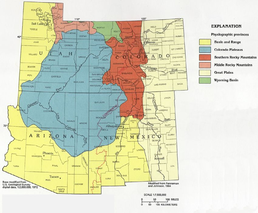
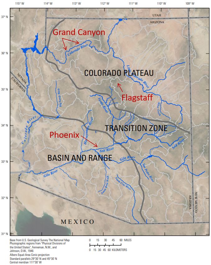
The Physiographic Provinces of Arizona across parts of Arizona, New Mexico, Colorado, and Utah
(fig. 12). The Colorado Plateau Province is bounded by the
Arizona is divided into three main physiographic provinces: Basin and Range Province from the northwest and extending
the Colorado Plateau, Transition Zone, and Basin and Range Prov- down to the south and southeast and the Rocky Mountains to
inces (fig. 11). The San Francisco Volcanic Field is located near the east (fig. 12), all of which have experienced intense tectonic
the southwest edge of the Colorado Plateau Province. For context, deformation. The Colorado Plateau Province, on the other hand,
the physiographic areas surrounding Flagstaff, the Grand Canyon, has remained largely undeformed and is considered to be in
and Phoenix have been annotated on figure 11, a map of Arizona. isostatic equilibrium (Levander and others, 2011).
Figure 11. Map of Arizona
showing the three main
physiographic provinces that
compose Arizona (Colorado
Plateau, Transition Zone,
and Basin and Range) in
black text (from Kennedy
and others, 2015). The
Grand Canyon, Flagstaff,
and Phoenix (red text) are
included for reference.A Brief Geologic History of the Colorado Plateau and San Francisco Volcanic Field 9
Figure 12. Map of the physiographic provinces in Utah, Colorado, Arizona, and New Mexico (Fenneman and Johnson, 1964; Robson and
Banta, 1995).
The mechanisms responsible for raising such a large others, 2011; Levander and others, 2011). Through various heat-
segment of the continental crust to over 2 km above sea level flow and convective-numerical modeling, researchers theorize
while maintaining its internal structure remain a contested that multiple uplift events occurred in the Colorado Plateau
topic (McQuarrie and Chase, 2000; Roberts and others, 2012, during the Laramide orogeny (late Mesozoic through middle
and references therein). Explanations include such processes Cenozoic Era) (Humphreys, 1995; Huntington and others,
as thickening through crustal shortening (McQuarrie and 2010), the middle Cenozoic Era (Humphreys and others, 2003;
Chase, 2000; Davis and Bump, 2009), partial removal of the Spencer, 1996), and late Cenozoic Era (Karlstrom and others,
mantle lithosphere through low-angle subduction (Spencer, 2008; Moucha and others, 2009; van Wijk and others, 2010).
1996) or from delamination (Zandt and others, 1995; Levander
and others, 2011), and magmatic injection (Morgan and
Swanberg, 1985). It is possible that a combination of some of Rock Ages of the Colorado Plateau Province
these mechanisms are responsible for the current state of the
Colorado Plateau Province. However, increasing evidence The Colorado Plateau Province predominantly comprises
supports Colorado Plateau Province uplift driven by convective sedimentary rocks formed during the Neoproterozoic, Paleozoic,
lithospheric downwelling (Karlstrom and others, 2008; Moucha and Mesozoic Eras (ranging in age from ~1.2 billion years ago
and others, 2008, 2009; van Wijk and others, 2010; Crow and [Ga] to 200 million years ago [Ma]), and are generally crystalline10 A Geologic Field Guide to S P Mountain and its Lava Flow, San Francisco Volcanic Field, Arizona
basement rocks of Paleoproterozoic age (~1.9–1.7 Ga) (Davis volcanic rocks cover much of the area. This entire package overlies
and Bump, 2009). During the deposition of Colorado Plateau Paleoproterozoic granite and schist, which are exposed at the base of
sedimentary rocks, crustal elevation was at or near sea level the Grand Canyon.
(Mooney and others, 1998; McQuarrie and Chase, 2000). Based
on current crustal-thickness maps, continental crust at sea level is
relatively thin, implying that the Colorado Plateau Province was also San Francisco Volcanic Field
thin (estimated to be ~30 kilometers [km] thick) and subsequently
increased in thickness after deposition of the sedimentary sequences Basalt of Miocene to early Pliocene age, referred to as
(McQuarrie and Chase, 2000). The San Francisco Volcanic Field, in rim basalts, border the south boundary of the Colorado Plateau
the southwestern Colorado Plateau Province, comprises sedimentary Province along the Mogollon Rim and extend up to the southern
rocks ranging in age from Cambrian (Tapeats Sandstone, ~545 Ma) boundary of the San Francisco Volcanic Field (Luedke and Smith,
to Triassic (Moenkopi Formation, ~240 Ma) (fig. 13), the younger 1978; Tanaka and others, 1986). The San Francisco Volcanic
Figure 13. Geologic block diagram showing the surface and subsurface geology of the Flagstaff area. The
numbers on the diagram correspond to the geologic units as follows: (1) Quaternary and Tertiary volcanic
rocks, (2) Moenkopi Formation, (3) Kaibab Formation, (4) Toroweap Formation, (5) Coconino Sandstone, (6)
Supai Group, (7) Redwall Limestone, (8) Martin Formation, (9) Mauv Limestone and Bright Angel Shale, (10)
Tapeats Sandstone, (11) Precambrian granite and schist (modified from Billingsley and others, 1980).A Brief Geologic History of the Colorado Plateau and San Francisco Volcanic Field 11 Field, a relatively young (late Cenozoic) volcanic field comprises bottom of figure 14), with the youngest volcano, Sunset Crater, more than 600 volcanoes, ranging in composition from mafic having erupted ~900 years ago (Robinson, 1913; Colton, 1936; (basaltic) to intermediate (basaltic andesite to andesite) and silicic Cooley, 1962; Moore and others, 1976; Tanaka and others, 1986; (dacite and rhyolite), and superposes some of these rim basalts Ort and others, 2002). (Tanaka and others, 1986). Bill Williams Mountain (a silicic volcano) and surrounding basaltic cones are the oldest volcanic features of the San Francisco Volcanic Field and overlie rim Fault Systems within the San Francisco basalts, questioning whether any time lapse occurred between the Volcanic Field waning of the Mogollon Rim volcanism and the start of the San Francisco Volcanic Field volcanism (Tanaka and others, 1986). The extent of the San Francisco Volcanic Field and its silicic The entire San Francisco Volcanic Field (outlined in orange in volcanoes, as well as the youngest volcano in the area (Sunset figure 14) stretches ~70 km north-south and ~100 km east-west Crater), the three major fault systems (Mesa Butte, Oak Creek across the southern Colorado Plateau Province. Apart from some Canyon, and Doney), and the northern extent of rim basalts are contemporaneous basaltic volcanism, in general the silicic and depicted in figures 14 and 15 (Ulrich and others, 1984; Holm, intermediate constructs (for example, Bill Williams Mountains, 1987; Newhall and others, 1987; Ulrich and Bailey, 1987; Wolfe Sitgreaves Mountain, Kendrick Peak, San Francisco Mountain, and others, 1987a, b; Conway and others, 1997). Shoemaker Elden Mountain, and other smaller domes) predate many of the and others (1978) postulated that these major fault systems, ~600 basaltic and basaltic-andesite vents (Tanaka and others, which trend to the northeast with downward motion to the east 1986; Riggs and Duffield, 2008). Various dating techniques, such (Ulrich and Bailey, 1987; Conway and others, 1997) originated as K-Ar radiometric dating (using for example, sanidine and deep within Proterozoic basement rocks and were subsequently plagioclase phenocrysts, and whole rock), have determined that reactivated during the late Cenozoic. Numerous volcanic vents the volcanic field decreases in age from west to east (shown along align with these faults, which likely influenced vent locations Figure 14. Digital elevation model (DEM) of the San Francisco Volcanic Field. Orange line is the boundary of the San Francisco Volcanic Field. The black arrow represents the volcanic field decreasing in age from west to east. Several major volcanic vents have been labeled, and the black box highlights the location of a future potential site for volcanic activity. S P Mountain is labeled as SP Crater. Base image provided by the National Aeronautics and Space Administration (NASA). Annotations by the Arizona Geological Survey (https://azgs.arizona.edu/photo/san-francisco-volcanic-field-arizona).
12   A Geologic Field Guide to S P Mountain and its Lava Flow, San Francisco Volcanic Field, Arizona

              Figure 15. Illustration of the extent of the San Francisco Volcanic Field (outline of image, not including the
              rim basalts; same outline as in figure 14, shown in orange) and its silicic and intermediate vents, major fault
              systems, and the northern extent of rim basalts. Numbers in parentheses are estimated ages in millions of years
              derived from K-Ar dating (using whole rock and individual phenocrysts, such as plagioclase and sanidine)
              (Tanaka and others 1986).

and allowed easier passage for magma to ascend to the surface.       with the evolved silicic melt generated in group 3 (Bloomfield
For example, Sitgreaves Mountain, Kendrick Peak, and Slate           and Arculus, 1989; Arculus and Gust, 1995; Chen and Arculus,
Mountain (all silicic vents) and Red Mountain cinder cone are        1995; Reid and others, 2012).
situated along the ~150 km long Mesa Butte fault system, and              To review the full range of volcanic rock types of the San
the Oak Creek Canyon fault lies directly beneath San Francisco       Francisco Volcanic Field, refer to Moore and Wolfe (1987),
Mountain (Shoemaker and others, 1978; Ulrich and Bailey, 1987;       Newhall and others (1987), Ulrich and Bailey (1987), and Wolfe
Conway and others, 1997).                                            and others (1987a, b).

Sources of Volcanic Rock Compositions
                                                                     Distributed Volcanism and Associated
      The San Francisco Volcanic Field is a unique volcanic
field because it includes a diverse and complete continuum of
                                                                     Volcanic Features
volcanic rocks, ranging from basalt to rhyolite in composition.
The likely petrogenetic origins for the range of volcanic rock       Distributed Volcanic Fields and Clusters
types that are found in the San Francisco Volcanic Field are
(group 1) basaltic magmas of various compositions sourced from            Typical distributed volcanic fields comprise numerous
both the lithospheric and asthenospheric mantle; (group 2) crystal   volcanic vents that are close together in space and time.
fractionation of these mafic magmas; (group 3) crustal melting,      Distributed volcanism is common on both Earth and Venus,
which resulted in the formation of an evolved silicic melt; or       though remnants of this type of volcanic distribution have also
(group 4) the mixing of melts from either group 1 (basaltic in       been observed on the Moon and possibly Mars (Campbell and
composition) or group 2 (an intermediate compositional melt)         others, 2009; Brož and Hauber, 2012). Vents within large volcanic
Distributed Volcanism and Associated Volcanic Features 13
fields (for example, San Francisco Volcanic Field) tend to form in on ascent rate and the extent to which gas bubbles grow and
clusters (Connor and others, 1992; Conway and others, 1998). For coalesce to form gas-rich pockets, the eruption can be dominated
example, S P Mountain is part of the S P cluster, which comprises by sporadic explosions or by continuous fountaining. The style
62 tephra cones, tuff rings, and spatter cones (Ulrich and Bailey, of eruption dominated by moderate to high fountains is called
1987; Conway and others, 1997) and spans an area of ~350 square Hawaiian, and highly vesicular lapilli-sized tephra are the most
kilometers (km2) (Conway and others, 1998). A combination of common eruptive product. The more sporadic style of eruption
radiometric and surface-exposure dating, geomorphology, volcanic is called Strombolian and usually produces less vesicular and
stratigraphy, and paleomagnetic data were used to acquire vent larger sized tephra. In both cases, the lava that is expelled into
ages (Ulrich and Bailey, 1987; Mullaney, 1996; Conway and the atmosphere usually cools very quickly, followed by varying
others, 1997; Tanaka and others, 1991; Fenton and Niedermann, degrees of fragmentation. The rapid cooling inhibits the growth
2014). The oldest basaltic flow in the vicinity of S P Mountain is of larger crystals and often quenches the liquid lava into a glass.
the Cedar Ranch mesa flow, which formed ~5.6 Ma (Ulrich and However, in some circumstances, the column of erupting lava is
Bailey, 1987). Volcanic activity within this area is estimated to so dense and energetic that the lava fragments are still fluid when
have lasted until ~16,000 years ago (~16 ka), most vents having they land, forming spatter. If the spatter deposit builds quickly, it
formed less than 780 ka (Conway and others, 1998). can retain sufficient heat for the clasts to weld together and form
agglutinates, a welded pyroclastic deposit. In the extreme case,
Eruption Styles the spatter deposit can be thick and fluid enough to remobilize
and flow as a rheomorphic lava flow. More commonly, the tephra
One of the main driving forces behind a volcanic eruption deposits fall to the ground as solid particles that, over time, build
is the expansion of volatiles; elements or compounds, like H2O an edifice around the vent. If the vent is focused around a single
and CO2, form a gas at relatively low pressure but are dissolved point, a cone like S P Mountain is built. If the vent is a fissure,
in magmas at depth (Wilson and Head, 1981). These volatiles the cone that will form will be more elongated; for example, the
will exsolve from the magma and coalesce as the magma ascends volcanic feature to the northeast of S P Mountain (fig. 16) is an
from depth in a conduit and decompression occurs. Depending elongated cone.
Figure 16. Satellite image of the field site includes S P Mountain, a structural graben, an elongated
cone, and Colton Crater. White boxes show locations of subsequent images and photographs. The
numbers indicate the corresponding figures. Image is by Esri, Maxar, GeoEye, Earthstar Geographics,
CNES and Airbus DS, U.S. Department of Agriculture (USDA), U.S. Geological Survey (USGS), AeroGrid,
IGN, and the GIS User community.14 A Geologic Field Guide to S P Mountain and its Lava Flow, San Francisco Volcanic Field, Arizona
Lava Flows an eruption age of ~6–5.5 ka, which is better aligned with
the geomorphic character of S P Mountain and its lava flow
Another common feature associated with volcanic fields (Rittenour and others, 2012).
are lava flows. In the San Francisco Volcanic Field, lava flows
are usually sourced by small vents near the base of tephra cones,
though some flow directly from the summit vent (Valentine Dimensions of S P Mountain and General Features
and Connor, 2015). Lava flows can occur concurrently with
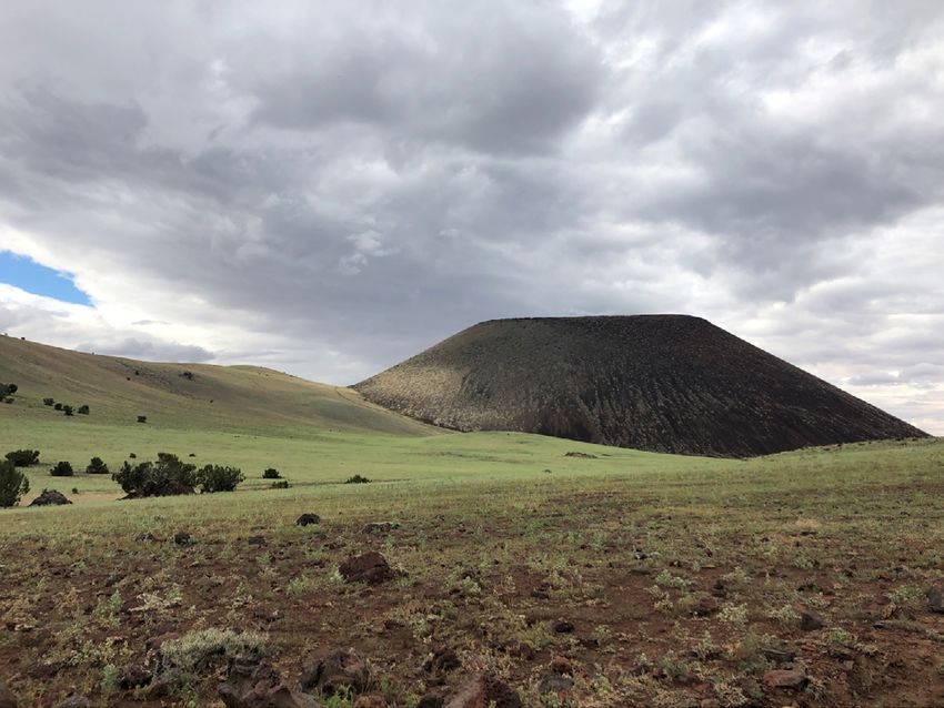
The volcanic cone is 250 meters (m) (820 feet [ft]) tall and
Strombolian and (or) Hawaiian eruptions, during which tephra will
its base is ~1,200 m (3,900 ft) in diameter (fig. 17) and is situated
often fall onto and coat the upper surface of the lava flow or after
on the lower flanks of a preexisting volcano located to the west.
the cone building stages have ended (in other words, tephra will
The summit crater is 400 m (1,300 ft) in diameter and ~120 m
not blanket the lava flow at this stage). S P Mountain is a classic
(400 ft) deep (Ulrich and Bailey, 1987). Both the block lava flow
example of a tephra cone and its co-eruptive lava flow.
that extruded from the cone’s base as well as the cone itself are
basaltic andesite in composition, and both were sourced from the
central vent (Ulrich and Bailey, 1987). The S P Mountain lava
S P Mountain and its Lava Flow flow extends to the north and covers older flows that erupted from
other local vents.
The Age of S P Mountain
Dimensions of S P Mountain Lava Flow and
S P Mountain is a tephra cone that formed during a General Features
single eruptive period, though the age of the eruption is still
uncertain. Surface-exposure dates using 3He and 21Ne (Fenton S P Mountain’s blocky lava flow is texturally different from
and Niedermann, 2014) and whole rock K-Ar radiometric the most common types of basaltic lava morphologies, that is,
dating (Baski, 1974) have yielded a similar eruption age of pāhoehoe and ‘a‘ā. Pāhoehoe lava flows display a smooth, often
~70 ka. However, based on the well-preserved morphology of ropy-like surface, whereas ‘a‘ā flows are rough, sharp, and have
S P Mountain compared to other cones in the San Francisco a rubbly surface. Block lava flows, on the other hand, tend to be
Volcanic Field, many researchers suggest this age is too old. more viscous, resulting in the lava cooling and fragmenting into
Rittenour and others (2012) used an additional technique for large polygonal blocks.
dating S P Mountain, optically stimulated luminescence (OSL) S P Mountain’s blocky lava flow is 7.0 km (4.3 miles)
of quartz xenocrysts within the flow. This method estimated long. Nearest to the cone, the flow is 250 m (820 ft) wide and
Figure 17. Photograph of an oblique view of S P Mountain (view to the south), showing the volcano’s dimensions. S P
Mountain is 250 meters (m) tall; its summit crater is 400 m in diameter, and its base is ~1,200 m in diameter. Photograph by M.
Elise Rumpf, U.S. Geological Survey.S P Mountain and its Lava Flow 15 15 m (50 ft) thick and spreads out to 3.9 km (2.4 miles) at its transported mounds of agglutinated near-vent material found widest and 55 m (180 ft) thick at its distal end (Ulrich and along the flow surface, a thin coating of both tephra and soil, Bailey, 1987). This flow displays two distinct surface textures and coverage by low grassy vegetation (Schaber and others, that can be observed both on the ground and aerially (fig. 18) 1980). Surface texture 2 displays a much blockier texture and and will be referred to as surface texture 1 and 2 herein. lacks all the previously described characteristics associated with Surface texture 1 has several distinct characteristics that include surface texture 1. Figure 18. Photographs of lava flow near S P Mountain showing the contrast between surface texture 1 and 2. A, Lava flow proximal to the base of S P Mountain (S P Mountain is located just out of the image, to the south). Arrows point to a lava levee. B, Oblique view of the lava flow. Surface texture 1 is coated by a thin layer of tephra and soil, is vegetated, and has transported mounds of the agglutinated material within the flow. Surface texture 2 lacks tephra and soil coverage, is much blockier, and has minimal vegetation growth. Photograph A is by Esri, Maxar, GeoEye, Earthstar Geographics, CNES and Airbus DS, USDA, USGS, AeroGRID, IGN, and the GIS User Community. Photograph B is by M. Elise Rumpf, U.S. Geological Survey.
16   A Geologic Field Guide to S P Mountain and its Lava Flow, San Francisco Volcanic Field, Arizona

Lava Flow Emplacement Theories                                                 Theory 2 describes the S P Mountain lava flow as
                                                                         comprising two separate, stacked flows. The theory delineates
      There is some uncertainty as to whether S P Mountain lava          the older flow (surface texture 1) to be the vegetated, soil- and
flow consists of one flow (theory 1) or two separate but stacked         tephra-covered flow that is exposed along the margins (Sabels,
flows that were emplaced at different stages during the eruption         1960; Weikart and others, 2008; Rittenour and others, 2012).
(theory 2). Theory 1 describes the different textures to be the result   The younger lava flow (surface texture 2) is absent of tephra
of varying degrees of cooling (Hodges, 1962; Schaber and others,         and soil coverage, lacks vegetation, and is much blockier.
1980). Hodges (1962) described surface texture 1 to be red basalts       Weikart and others (2008) suggest the older lava flow erupted
that appear highly weathered. These basalts are typically found          concurrently with the Strombolian eruptions responsible for
along the margins of the flow and are always associated with soil        building the cone of S P Mountain. This initial lava flow was
accumulation and vegetation. Hodges (1962) postulated that as the        destructive, in which agglutinated material from the cone was
lava flow extruded from the vent, the margins of the flow cooled         ripped off and transported downstream. As the mass flux for
much faster than its insulated interior. Therefore, the rapidly          the lava flow decreased, Strombolian activity continued and
cooled margins have a higher glass content compared to the flow          rebuilt the cone. The final lava flow erupted after the cone-
interior and can alter more readily. In addition, Hodges (1962)          building phase had ceased and was not destructive to the cone,
speculated that the margins have an increased concentration of           indicated by a lack of tephra coverage and agglutinated cone
gases during eruption, which can result in a higher oxidation            material on the flow, respectively.
to the basalt flow. The combination of oxidation and high glass
content thus causes this portion of the flow to be weathered at a
higher rate and therefore has increased soil accumulation. Hodges        S P Graben
(1962) described surface texture 2 as being a typical block flow,
characterized by its equidimensional-polygonal blocks that formed              Along the western margins of the S P Mountain lava flow,
when the lava cooled and contracted.                                     the flow spilled into a graben at two separate locations (fig.  20).
      Roughly 4.5 km downstream from where the lava extruded             Named S P graben by Babenroth and Strahler (1945), this
from the vent is an outcrop of altered red basalt that extends from      graben trends to the north, is ~13 km (8 miles) long and ~400  m
the margins of the flow to its interior (fig. 19). Hodges (1962)         (0.25  miles) wide. The graben walls are asymmetric, the western
suggested that the now altered red basalt was part of an initial lava    wall stands ~60 m (200 ft) tall and the eastern wall extends ~14  m
flow eruption phase that began to cool and solidify. A subsequent,       (45 ft) above the graben floor (Babenroth and Strahler, 1945). The
secondary pulse of lava was obstructed by the initial, now-cooled        graben is exposed in Kaibab Limestone, though its floor has been
lava and was forced to divert to the east.                               covered by younger lava flows and sediment.

Figure 19. Photograph
of an agglutinated mound
that was transported
away from the vent
downstream. This mound
is near the spillover, closer
to S P Mountain, into
the graben.  Photograph
by Amber Gullikson and
M. Elise Rumpf, U.S.
Geological Survey.
Getting to S P Mountain 17
Figure 20. Photographs of the S P Mountain lava flow showing the graben and spillovers. A, Satellite view of the two lava spillovers
into the graben (highlighted by a white box). B, An oblique view of the spillover nearest to the vent. Photograph A is by of Esri, Maxar,
GeoEye, Earthstar Geographics, CNES and Airbus DS, USDA, USGS, AeroGRID, IGN, and the GIS User Community. Photograph B is by
M. Elise Rumpf, U.S. Geological Survey.
Getting to S P Mountain dirt road and drive for 7 miles. At mile 3.2, the road will begin
to veer south and parallel to the S P Mountain lava flow.
When both the lava flow and tephra cone come into view,
Take U.S. Highway 89 north from Flagstaff. Once review figure 21 to determine what type of morphologic features
Highway 89 diverts from both Interstate 40 and Historic Route can be identified. Observe the location of the source of the lava
66, travel an additional 29.4 miles on Highway 89. Once past flow (that is, the contact between the lava flow and the tephra
the turnoff for the Wupatki National Monument (on the east cone), the lava flow itself, possible transported mounds, crater rim,
side of the road), the turnoff onto the unmarked dirt road will fallout-dominated beds, and the debris apron. Numerous degraded
be 3.0 miles farther north on the left. Turn left (west) onto the cones are visible to the north and south as you drive along this road.
Figure 21. Schematic cross section of a typical tephra cone. Depicted in this illustration are both volcanic sedimentary processes and
geomorphic structures. Illustration from Kereszturi and Nemeth (2012).18 A Geologic Field Guide to S P Mountain and its Lava Flow, San Francisco Volcanic Field, Arizona
At mile 7, the road crosses over the S P Mountain lava flow.
Drive over the lava flow and park on the left (south) side of the
Stop 1. Source of the Lava Flow
road. A disused road traverses up the saddle; turnoff and park near Walk back east along the road until you reach the lava
this old road (lat 35°35’20.34” N., long 111°38’14.7” W.) (fig. 22). flow, then turn south, and hike along the flow until you near
the base of S P Mountain. This stop is located near the contact
Disclaimer between the lava flow and the tephra cone (fig. 22).
Goal.—Describe the types of tephra observed at this location.
S P Mountain is located on private property, owned by Need to know.—This is the location where the lava flow
the Babbitt family. The Babbitts generously allow public use of extrudes from the base of the cone (outpour point in figure 21). As
their land, though it is expected that wildlife and cattle are not lava flows out from this point, portions of the cone can be ripped
disturbed, and artifacts and rocks are left in place. Please refrain away and transported by the lava flow. Such transported mounds
from smoking or having open flames of any kind while on the of the cone will be observed at the lava flow and graben stops
land. If you plan to do any sampling, operate drones, or use other (stop 3 and 5, respectively).
instrumentation, please contact the Babbitts at https://www. A few tens of meters from the contact (and more pronounced
babbittranches.com/contact-us. at the lava flow stop [stop 3]) are levees. Lava flow levees form
In addition, hiking up S P Mountain can be very strenuous. from cooled lava at the edge of active lava flows. They build
You will encounter loose rocks and cacti. Do not try to hike S P higher with periodic flux increases that cause lava to spill out of
Mountain if you do not have plenty of water and are not wearing the channel. As the flux of lava in the channel wanes at the end of
appropriate clothing and shoes. During the summer months an effusion event, the interior of the channel drains and leaves high
temperatures can be high, especially when hiking on basalt, so standing levees, which record the maximum height of the flow
please plan accordingly. (figs. 23 and 24).
Figure 22. Satellite image of S P Mountain, highlighting the locations of the first four stops of the field
guide. The circle shows the location where cars should park for these stops. The white dashed line shows
the preferred hiking path to stop 4, the rim. Image is by Esri, Maxar, GeoEye, Earthstar Geographics, CNES
and Airbus DS, U.S. Department of Agriculture (USDA), U.S. Geological Survey (USGS), AeroGrid, IGN, and
the GIS User community.You can also read