Guide to the PIF Population Estimates Database
←
→
Page content transcription
If your browser does not render page correctly, please read the page content below
Guide to the PIF Population Estimates Database
Version: North American Landbird Conservation Plan 2004

                    Partners in Flight Science Committee

              Partners in Flight Technical Publication No. 5

                                        July 2007

Suggested citation:
Blancher, P. J., K. V. Rosenberg, A. O. Panjabi, B. Altman, J. Bart, C. J. Beardmore, G. S.
Butcher, D. Demarest, R. Dettmers, E. H. Dunn, W. Easton, W. C. Hunter, E. E. Iñigo-Elias, D. N.
Pashley, C. J. Ralph, T. D. Rich, C. M. Rustay, J. M. Ruth, and T. C. Will. 2007. Guide to the
Partners in Flight Population Estimates Database. Version: North American Landbird
Conservation Plan 2004. Partners in Flight Technical Series No 5.
http://www.partnersinflight.org/
Preface
This document describes the content of the Partners in Flight (PIF) Population Estimates Database
(http://www.rmbo.org/pif_db/laped/about.aspx), which provides population estimates for North
American landbirds at several geographic scales. It also provides details about how the estimates
were derived, some information on potential uses of the data and caveats, and future directions for
revising these estimates.

This version of the database is intended as a companion to PIF North American Landbird
Conservation Plan (Rich et al. 2004), and as such, estimates included in the database have not
been modified from those used in that Plan. Most of those estimates were based on Breeding Bird
Survey data from the 1990s decade. A future version of the database will contain updated
estimates, incorporating more recent data, feedback from users, alternative estimates, and
additional adjustments where other data indicate changes are needed.

Contents:

   Background

      Methods and Technical Details
   Geographic Scale of Estimates
   Deriving the Population Estimates
   Data Quality & Limitations

      Uses of Data and Next Steps
   Overview of Estimates
   Potential Uses of the Data
   Next Steps

   Acknowledgements
   Literature Cited

     Appendices
   Appendix 1: Examples of Population Estimates
   Appendix 2: Data Dictionary
Background Population size is a central measure in most species assessment schemes, particularly those aimed at identifying species with a high risk of extinction (e.g., IUCN 2001, various national endangered species programs). Small populations are generally considered more vulnerable than large ones, even among those species not immediately at risk. Partners in Flight includes global Population Size as one of several factors assessed to determine species of high conservation importance (Panjabi et al. 2005), using an order of magnitude scale to assess relative risk. The PIF North American Landbird Conservation Plan (Rich et al. 2004) published global population size estimates for 448 native landbirds of the U.S. and Canada. These estimates were used in assessing conservation importance of individual species, and immediacy of conservation action required. They were also included to give a sense of the magnitude of the task of meeting Plan objectives, for example to achieve a doubling of a species' current population. Meeting continental objectives requires actions at regional scales, and many requests were received to break the continental population estimates down to smaller geographic scales, where they could be used as a starting point in setting regional objectives or judging the magnitude of actions needed to meet those objectives. AFWA state reports (Rosenberg 2004) provided that breakdown for priority species in each U.S. state. However the data behind the estimates have not been widely provided, making it difficult to interpret or revise estimates in light of other regional data and expertise, or to use the data for other related needs. The purpose of this PIF population estimates database is to make these data broadly available, and to provide a base for future improvements to the estimates. Relative abundance counts from the North American Breeding Bird Survey (BBS) form the basis of most estimates provided here. Though the BBS was not designed specifically to produce population estimates, and there are difficulties to overcome as a result, there are important advantages. The main ones are that data from across much of North America have been collected according to a single standardized method, surveys employ random start points and directions thus enhancing regional representation of the avifauna (roadside bias notwithstanding), and the data are readily available for the bulk of North American landbirds.
Geographic Scale of Estimates
Estimates are presented in the database at the following geographic scales:

   •   Global population estimates for North American landbirds;
   •   North America (Canada and continental U.S.)
   •   BBS coverage area (North America minus arctic Canada)
   •   Bird Conservation Regions (BCRs, U.S. NABCI Committee 2000 http://www.nabci-
       us.org/map.html)
   •   Individual States, Provinces and Territories; and
   •   BCRs within States, Provinces and Territories (hereafter referred to as geopolitical
       regions)

For species whose estimates were based on BBS data, estimates within geopolitical regions were
the building blocks for estimates at larger scales. For example population estimates for North
Dakota have been rolled up from estimates within BCR 11 and BCR 17 portions of North Dakota;
estimates for BCR 12 encompass estimates from six states and provinces that intersect that BCR.
Estimates within geopolitical regions are more likely to suffer from small sample sizes and/or high
variance than those at larger scales (see section on Data Quality & Limitations below). They are
provided here so that users have access to all of the data that went into estimates at larger scales,
and also for those that want to work with the data at that smaller scale.

Deriving the Population Estimates
For estimates based on BBS data, the general formula used to calculate an estimate within each
geopolitical region was:

Population Estimate = BBS Average / Area Sampled x Region Area x Detection Adjustments

Each component of the formula above is described further below:

BBS Average (birds per route):

BBS counts per route provided the basic data on relative abundance. They were used because they
provide comparable values according to a standard technique across much of North America.
BBS routes are restricted to roadsides, so there is some habitat bias, the amount and direction
dependant on species and region. However, start points and direction for BBS routes are
randomly determined, minimizing selection bias and providing a reasonably representative sample
of the avifauna in most regions.

BBS data were selected from the full 1990s decade (1990 through 1999) in order to create an
estimate that would be reasonably robust to year-to-year natural variation in abundance, as well as
being relatively insensitive to changes in which BBS routes were run in a given year, or which
observers ran the routes. (An exception was made in boreal BCRs 7 and 8, where data from routes
surveyed only in previous decades were included to augment geographic coverage.) Only those
data with runtype=1 were included. Counts were averaged across years within each route, with
zeros (no birds in a year's count) included in the average. These route averages were themselves
averaged across routes within each geopolitical region, again including zeros in the average. As a
result, each BBS route sampled under acceptable conditions in at least one year during the 1990s
decade was equally weighted with each other BBS route in the same region, regardless of number
of years sampled, or presence or absence of individual bird species.
Users should be aware that abundance of some species has changed significantly since the 1990s.
Area Sampled:
The area sampled by a BBS route was based on the 400 m limit within which birds observed are
counted, giving a potential area covered of 25.1 km2 per route (50 x x (0.4)2). BBS average
divided by area sampled per route gives an estimate of density of birds. Of course, not all birds
are detectable out to the 400 m limit, and others may be effectively detected at a greater distance
(very loud calls, birds that fly into the count area during the count). These species-specific
differences in detection distance are dealt with below (see Detection Distance).
Geopolitical Region Area:
The area of each geopolitical region was used to extrapolate estimates from the scale of a BBS
route to the full region. Area, reported here in square kilometers, was derived from an overlay of
BCR and State and Province shape files. It excludes the area of water in very large lakes the size
of Utah's Great Salt Lake or larger (e.g., all of the Great Lakes were excluded, as were several
large lakes between Lake Winnipeg, Manitoba and Great Bear Lake, Northwest Territories).
Detection Adjustments:
Clearly not all birds present with the 400 m bounds of each BBS stop are detected within 3 minute
counts. Ideally we would like to have a measure of the proportion of birds present that are
detected at BBS stops. This proportion will vary by species, habitat and location, and will take
much further research and review of existing information to obtain. Instead, we have used three
measures to adjust the population estimate to approximate detectability of individual species.
Each is intended to be used together with BBS data to get an approximate estimate of population
size.
Detection Distance:
Each species has been placed into one of 5 detection distance categories: 80, 125, 200, 400 and
800 m, based on literature (Rosenberg and Blancher 2005), and a consideration of habitat, strength
of song, and behaviour of the bird (amount of time spent in flight, secretiveness). Distance classes
used here tend to be larger than estimates from empirically derived effective distances (e.g. from
program Distance http://www.ruwpa.st-and.ac.uk/distance/), in part because we have also adjusted
density with pair and time of day adjustments (see below), but also because movement of birds
during counts means that a larger area has been sampled than is indicated by the distance to bird
detections. Population estimates in this database are strongly sensitive to detection distance used,for example if detection distance is halved, the population estimate is quadrupled. Refinement of
detection distances is thus an important area for future work.
Pair adjustment:
In all estimates based on BBS we have assumed that on average there are 2 birds within detection
distance for every one detected at peak time of day. That is, we have multiplied bird counts by 2
to estimate number of breeding birds. For many songbirds, counts at the peak time of day are of
singing males, with females relatively rarely detected. For other breeding birds, time spent out of
view at nests or perched in silence will often result in only one member of a pair being detected.
This pair adjustment may lead to an overestimate of population if detected birds are often
unpaired, if both sexes are conspicuous when present, or when family groups are counted. It will
lead to an underestimate for birds in which both members of pairs are often not detected, even at
peak detection time of day within typical detection distance.
Time of Day adjustment:
Detectability of most bird species is strongly influenced by the time of day a count is taken, often
showing a strong increase and/or decrease during the 4-5 hours of a BBS survey. We calculated a
species-specific time of day adjustment to adjust the BBS average upwards to the peak time of
detection, by dividing the count at peak BBS stops by the average count across all BBS stops. The
main assumption here is that birds are missed at all other times of the survey in proportion to the
degree to which counts are below this peak of detection. This adjustment will be an underestimate
for species whose peak time of detection falls outside of BBS morning hours, principally some
crepuscular and nocturnal species.
The peak time of detection was determined using stop-by-stop data from all BBS routes survey-
wide (data were available primarily from the period 1997 to 2002). Average number of birds
counted per stop was calculated for each BBS route, then birds at each BBS stop number (1
through 50) were summed across all BBS routes. A 6th-order polynomial regression was fitted to
these data to produce a smoothed maximum count. Smoothing was necessary to remove variation
among stops unrelated to time of day. The time of day adjustment was then simply the smoothed
maximum count divided by the average count (see Fig. 4 and 5 in Appendix 1, also Rosenberg &
Blancher 2005).
Calculation of the peak time of detection assumes that suitable habitat is found in similar amounts
early or late in the BBS survey morning, when summed across many BBS routes. For many
species, data from large numbers of routes results in a relatively robust time of day adjustment.
For species detected on few BBS routes, or for species that are highly colonial, time of day
patterns are more difficult to separate from random variation among stops. For species found on
fewer than 50 routes, where no pattern was discernable, an average time of day adjustment for all
diurnal landbirds (1.32) was assigned, or else the time adjustment of a close congener was used.
For a few species with peak of detection late in the BBS survey day, smoothed maximums were
limited to stops 47 or below, to avoid potential over fitting of imprecise counts with high order
polynomials.Regional variation in time of day adjustments is not considered here, because most species do not
have sufficient sample sizes to calculate separate adjustments in each region. However
examination of daily patterns for a selection of widespread landbirds indicated generally similar
adjustments and time of day patterns across regions for most species.
Other Possible Adjustments:
No adjustments have been made to correct for habitat bias in BBS coverage, seasonal peaks in
detection outside of BBS survey dates, or for low detection rates among secretive birds. Where
data exist to address these issues, users may wish to apply their own adjustments to the data (see
section on Uses of Data below).
Population Estimates based on NT/NU checklists:
There were no BBS data in the 1990s in arctic Canada (Canadian part of BCR 3). Because this
region is so large (approx. 2.6 million km2), it was not useful to extrapolate estimates from the
Alaskan part of BCR 3. Instead we used a combination of density estimates from the Breeding
Bird Census (BBC, Kennedy et al. 1999) and relative abundance from the Northwest Territories
and Nunavut Bird Checklist Survey (hereafter NT/NU checklist) to estimate population size of
landbirds in the arctic. Details of the methods are presented in Appendix B of Rich et al. (2004,
pg. 79). Checklist data came from 649 sites visited between 1995 and 2001.
Extrapolation to Global Estimates:
Fewer than half of the landbird species in the database have breeding ranges confined to North
America. For the rest, estimates of global population size were extrapolated from North American
estimates based on the proportion of the world’s population that breeds in North America,
estimated from published range maps. Where a species had more than 90% of breeding range
outside of North America, global population size was estimated to an order of magnitude by the
PIF Science Committee, rather than rely on a very large extrapolation from North America.
Global population estimates are used for two purposes by PIF:
– for calculating a Population Size assessment score (PS), which required an order of magnitude
resolution on the estimate;
– for estimating the proportion of global population that breeds in North American or in any
region within North America. This helps understand a region’s responsibility for the species.
Other Sources of Population Estimates:
For some species, better sources of population estimates were available at a continental scale.
Sources for these estimates are provided in “Source” fields in the database. For these species,
estimates are generally provided only at a continental scale, and are not yet included in regional
breakdowns.Data Quality & Limitations
We provide a rating system to give users a measure of the quality and quantity of data on which
the population estimates have been based. Lower ratings indicate some combination of low
sample size, high variance in BBS counts, or an otherwise poorly sampled species. Species
estimates are more often rated poorly at smaller geographic scales, mainly because of smaller
sample sizes resulting in reduced precision.
It is important to note that these ratings are specific to calculation of the BBS average used in the
estimate, and do not cover other aspects of the population estimate, such as uncertainty in
detection adjustments, or potential for habitat bias. For that reason, users should be aware that an
estimate that is based on good quality data, with green data quality ratings, will still have
substantial uncertainty associated with it (see Thogmartin et al. 2006 for a review of limitations
associated with these methods). For example, estimates are particularly sensitive to the detection
distance chosen for use with each species.
The database also includes population estimates from other sources for a limited number of
species, including some subject to intensive species-specific surveys. In most cases, data quality
ratings have not been included for those estimates.
Regional Data Quality Ratings
All ratings were scaled from green (relatively good data quality and quantity), through beige,
yellow and orange to red (very little data or based on extrapolation from a neighbouring region),
reflecting a decreasing quality and/or quantity of data on which estimates were based. The
following four types of ratings have been included with regional data:
BBS Variance Rating
Variance in the average count among BBS routes within a region is reflected in this rating. A
ninety-five percent confidence interval was calculated about the regional average, and then
expressed as a percent of the regional average (see example in Appendix 1). This confidence
interval reflects the magnitude of variance in counts among routes, and is also sensitive to the
number of routes run in the region. Population estimates based on BBS averages with high
variance will themselves be imprecise.
The cutoffs used were:
Green rating – 95% confidence limits on the regional average were within 25% of the average;
Beige – 95% confidence limits within 50% of the regional average;
Yellow – 95% confidence limits within 100% of the regional average;
Orange – 95% confidence limits within 200% of the regional average;
Red – 95% confidence limits exceed 200% of the regional average, or insufficient data to calculate
a confidence interval.Species Sample Size Rating
For the most part, the BBS variance rating above is sufficient to indicate limitations due to low
sample size, i.e., regional estimates based on few BBS routes. However some regional BBS
averages with low variance are associated with species presence on very few routes, even though
many routes have been sampled in the region. These are flagged with a low species sample size
rating, since detection of a species on one more, or one fewer, route could significantly alter the
population estimate.
Cutoffs used were:
Green – species detected on at least 5 BBS routes in the region;
Beige – species detected on 3-4 BBS routes in the region;
Yellow – species detected on 2 BBS routes in the region;
Orange – species detected on 1 BBS route in the region;
Red – species not detected on BBS routes in the region; regional average extrapolated from
neighbouring region(s).
BBS Range Coverage Rating
BBS routes were run in the 1990s in almost every degree block of latitude and longitude across
southern Canada and the lower 48 U.S. states. However in Alaska and most parts of Canada, BBS
coverage of degree blocks is intermittent, and is often not evenly distributed. The BBS range
coverage rating reflects the percentage of a species’ breeding range in a region that is within
degree blocks covered by BBS, with cutoffs as follows:
Green – 2/3rds or more of breeding range covered by BBS, at scale of lat/long degree blocks;
Beige – 1/3 or more of range covered by BBS;
Yellow – 10% or more of range covered by BBS;
Orange – < 10% of range covered by BBS;
Red – no BBS sampling in region; regional average extrapolated from neighbouring region(s).
Overall Data Quality Rating
This rating summarizes the previous 3 ratings, and is the one rating that appears on screen in
regional web queries. Its value simply reflects the poorest of the three previous ratings; for most
species in most regions it has the same value as the Variance Rating.
Continental and Global Data Quality Ratings
Data quality ratings at continental and global scales are the same as those presented above for
regional estimates, with the following two exceptions:Coverage Ratings:
In the continental / global estimate part of the database, coverage ratings are presented for BBS
survey-wide, for North America as a whole, and for the species’ global range. In each case the
rating cutoffs are the same:
Green – 2/3rds or more of breeding range covered by BBS;
Beige – 1/3 or more of range covered by BBS;
Yellow – 10% or more of range covered by BBS;
Orange – < 10% of range covered by BBS;
Red – no BBS sampling in region; regional average extrapolated from neighbouring region(s).
For example, Turkey Vulture (Cathartes aura) range within the BBS survey area is almost
completely sampled by BBS routes (98%), as is its range in North America as a whole (i.e.
including arctic Canada, 98%), so BBS coverage and North American coverage ratings are both
green. However only about 29% of its breeding range is in North America, resulting in 28%
coverage at the global scale (98% x 29%), and a yellow Global coverage rating. That is, there is
greater uncertainty in the global estimate due to the rather large extrapolation from the North
American estimate to the global scale.
BBS Species Flag:
A species-specific flag has been added at the continental scale to indicate species that are
potentially poorly sampled by BBS methods. This includes nocturnal and crepuscular species
whose peak of activity may not be captured by BBS, species with imprecise BBS trends indicating
poor sampling by BBS (identified as "Mo2" species under “Monitoring Need” in Appendix A of
Rich et al. 2004), species detected on few routes within their breeding range (Overview of Estimates
About ¾ of the 456 North American landbird species included in this database have global
population estimates of 1 Million or more breeding birds (Fig. 1). Close to half have global
estimates in the 1 to 10 Million range, whereas fewer than 3% of species have estimates below
10,000.
50%
45.8%
40%
Percent of Species
30%
25.2%
20% 18.2%
10%
4.4% 4.2%
0.7% 1.5%
0%of species), and/or with countries elsewhere in the world (11%). However, 70% of these landbirds
rely on North America for at least half of their breeding range/population.
1,200
1,000
Millions of Birds
800
600
400
200
0
ae
ae
ae
ae
ae
ae
e
ae
ae
e
ae
ae
da
da
id
llid
id
id
lid
id
id
lid
rid
id
ni
bi
riz
on
ul
in
nn
rd
na
ru
te
gi
ur
um
eg
nd
Tu
be
re
ra
Pa
Ic
in
di
St
iru
R
ol
Vi
Fr
Ty
ar
Em
C
H
C
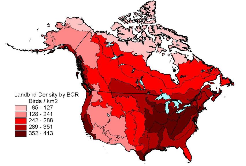
Figure 2: North American population estimates by landbird family (12 of 45 families shown)
Figure 3: Estimated Landbird Density by Bird Conservation RegionPotential Uses of the Data These population estimates are rough approximations for landbirds breeding in the U.S. and Canada. The estimates are based on data from the Breeding Bird Survey, which was designed to derive indices of population trend, not measures of population density. (Thogmartin et al. 2006). In particular, the number and proportion of undetected birds present during BBS counts are unknown, and only roughly estimated here. Nevertheless, the results and the underlying data of this first effort to estimate population numbers for all North American landbirds can be used for several different purposes, including a few outlined briefly below. To set regional objectives and advance conservation design. Success in meeting objectives outlined in the PIF North American Landbird Conservation Plan will depend heavily on setting biologically sound, measurable, population-based habitat targets at regional and local scales and implementing actions toward these targets (Will et al. 2005). Data and estimates provided here may advance conservation design by framing the magnitude and connectivity of the resource. Users should look critically at regional habitat bias in BBS counts, habitat-specific detection distances where known, and supplement or replace BBS averages with better data from other sources where available. To compare with independent estimates of population size and mortality. Species status reports rely on population estimates from a variety of sources, and this database may be useful in that context. These estimates can also provide continental and regional context for environmental impact assessments and the cumulative effects of various sources of mortality on bird populations, population vulnerability and resiliency. To obtain more accurate estimates. The current data or the approach used here could be modified to be more accurate in a given region, for example by measuring the degree of habitat bias in a region and adjusting results accordingly, by modifying detection distances based on independent data, or by supplementing BBS data with other abundance or density data. The PIF Science Committee plans to provide revised version(s) of this database in future. To provide data on a region's importance to a species. The database contains information on the proportion of population in each region, as well as the area of breeding range of each species in each region (range sizes were based on an overlay of NatureServe 2.1 digital maps (Ridgely et al. 2005) on regional shape files). These measures give an indication of how important a region is to the species breeding population, and how much of the region is occupied. Next Steps The Partners in Flight Science Committee will update this database in the next year or two. Much constructive input has been received already from readers of the North American landbird plan, and from users of earlier versions of spreadsheets contained in this database. The committee is
currently working on some of the improvements suggested by Thogmartin et al. (2006). Here are
a few revisions likely to be included in a future version of the database:

   -   update to the most recent decade of BBS data
   -   revised time of day adjustment factors
   -   species-specific pair correction factors
   -   refinement of detection distances used, based on data from surveys where distances and/or
       detection probability were estimated
   -   inclusion of additional independent estimates, from the literature or unpublished data
   -   consideration of additional adjustments, e.g., seasonal adjustment for early spring breeders,
       regional adjustment for habitat coverage bias
   -   additional measures of variance
Acknowledgements Thanks to Chandman Sambuu for developing the web application for this database, to Rocky Mountain Bird Observatory for hosting it, and to the National Fish and Wildlife Foundation for funding the web application work. The database is heavily reliant on the North American BBS dataset; we are grateful to the thousands of volunteers and many BBS coordinators who helped with collection of the data, and to the U.S. Geological Survey and Canadian Wildlife Service for screening and making the data readily available on line. We also thank Craig Machtans, Judith Kennedy, Environment Canada and all others responsible for collecting and providing data from the Northwest Territories and Nunavut Bird Checklist Survey and from Breeding Bird Censuses in arctic Canada. For quantifying range sizes we relied on digital distribution maps of birds provided by NatureServe in collaboration with Robert Ridgely, James Zook, The Nature Conservancy - Migratory Bird Program, Conservation International - Center for Applied Biodiversity Science, World Wildlife Fund - US, and Environment Canada -WildSpace (see Ridgely et al. 2005). A peer review of this project organized and hosted by the USGS in 2004 led to publication of a review (Thogmartin et al. 2006) that provides many constructive avenues for improving population estimates and future versions of this database. Thanks to members of the peer review committee and to the USGS for undertaking that task. Finally we appreciate the feedback on various estimates we have received from a variety of scientists since publication of the North American Landbird Conservation Plan. That input has not been incorporated into the current version of database, since it reflects the data as they were constructed for the Plan, but will be very useful as revisions are made. Literature Cited Blockstein, D. E. 2002. Passenger Pigeon (Ectopistes migratorius). In The Birds of North America, No. 611 (A. Poole and F. Gill, eds.). The Birds of North America, Inc., Philadelphia, PA. IUCN. 2001. IUCN Red List Categories and Criteria: Version 3.1. IUCN Species Survival Commission. IUCN, Gland, Switzerland and Cambridge, UK. ii + 30 pp. http://intranet.iucn.org/webfiles/doc/SSC/RedList/redlistcatsenglish.pdf Kennedy, J. A., P. Dilworth-Christie, and A. J. Erskine. 1999. The Canadian Breeding Bird (Mapping) Census Database. Technical Report Series No. 342, Canadian Wildlife Service, Ottawa, Ontario. http://dsp-psd.pwgsc.gc.ca/Collection/CW69-5-342E.pdf Northwest Territories / Nunavut Bird Checklist Survey. http://www.mb.ec.gc.ca/nature/migratorybirds/nwtbcs/index.en.html
Panjabi, A. O., E. H. Dunn, P. J. Blancher, W. C. Hunter, B. Altman, J. Bart, C. J. Beardmore, H.
   Berlanga, G. S. Butcher, S. K. Davis, D. W. Demarest, R. Dettmers, W. Easton, H. Gomez de
   Silva Garza, E. E. Iñigo-Elias, D. N. Pashley, C. J. Ralph, T. D. Rich, K. V. Rosenberg, C. M.
   Rustay, J. M. Ruth, J. S. Wendt, and T. C. Will. 2005. The Partners in Flight Handbook on
   Species Assessment. Version 2005. Partners in Flight Technical Series No. 3. Rocky Mountain
   Bird Observatory website: http://www.rmbo.org/pubs/downloads/Handbook2005.pdf

Rich, T. D., C. J. Beardmore, H. Berlanga, P. J. Blancher, M. S. W. Bradstreet, G. S. Butcher, D.
   W. Demarest, E. H. Dunn, W. C. Hunter, E. E. Iñigo-Elias, J. A. Kennedy, A. M. Martell, A. O.
   Panjabi, D. N. Pashley, K. V. Rosenberg, C. M. Rustay, J. S. Wendt, and T. C. Will. 2004.
   Partners in Flight North American Landbird Conservation Plan. Cornell Lab of Ornithology.
   Ithaca, New York. http://www.partnersinflight.org/cont_plan/default.htm

Ridgely, R. S., T. F. Allnutt, T. Brooks, D. K. McNicol, D. W. Mehlman, B. E. Young, and J. R.
   Zook. 2005. Digital Distribution Maps of the Birds of the Western Hemisphere, version 2.1.
   NatureServe, Arlington, Virginia, USA. http://www.natureserve.org/getData/birdMaps.jsp

Rosenberg, K. V. 2004. Association of Fish and Wildlife Agencies Partners in Flight Landbird
   Reports. http://fishwildlife.org/allbird_landbird.html

Rosenberg, K. V. and P. J. Blancher. 2005. Setting Numerical Population Objectives for Priority
   Landbird Species. Pages 57-67 in C.J. Ralph and T.D. Rich (eds.), Bird conservation and
   implementation in the Americas: proceedings of the Third International Partners in Flight
   Conference. Vol. 1. United States Department of Agriculture, Forest Service, Pacific
   Southwest Research Station, General Technical Report PSW-GTR-191. Albany, CA
   http://www.fs.fed.us/psw/publications/documents/psw_gtr191/Asilomar/pdfs/57-67.pdf

Shorger, A. W. 1955. The Passenger Pigeon: its natural history and extinction. Univ. of Wisconsin
   Press, Madison.

Thogmartin, W. E., F. P. Howe, F. C. James, D. H. Johnson, E. T. Reed, J. R. Sauer, and F. R.
   Thompson III. 2006. A review of the population estimation approach of the North American
   landbird conservation plan. Auk 123:892–904.
   http://www.umesc.usgs.gov/documents/publications/2006/thogmartin-etal-auk-
   pifcommentary_2006.pdf

U.S. NABCI Committee. 2000. North American Bird Conservation Initiative. Bird Conservation
   Region Descriptions. A Supplement to the North American Bird Conservation Initiative Bird
   Conservation Regions Map. September 2000. http://www.nabci-
   us.org/aboutnabci/bcrdescrip.pdf

Will, T. C, J. M. Ruth, K. V. Rosenberg, D. Krueper, D. Hahn, J. Fitzgerald, R. Dettmers, C. J.
   Beardmore. 2005. The five elements process: designing optimal landscapes to meet bird
   conservation objectives. Partners in Flight Technical Series No. 1. Partners in Flight website:
   http://www.partnersinflight.org/pubs/ts/01-FiveElements.pdf.
Appendix 1: Examples of population estimates based on BBS data
The following examples illustrate how BBS data have been combined with detection adjustment
factors and distribution maps to estimate regional and continental population sizes.

Wood Thrush – Regional estimates

BBS Regional Data: Wood Thrush (Hylocichla mustelina) is a common woodland bird in the
Lower Great Lakes / St. Lawrence Plain bird conservation region (BCR 13). It was detected on
149 of 157 BBS routes run in the region in the 1990s (Table 1a,b). Average birds per route per
year varied from 0.8 in Quebec to 12.3 in Vermont, with an overall area-weighted mean of 5.3
(Table 1c). The 95% confidence limits on the mean were 0.39 above and below the mean, or 7%
of the mean (Table 1e), reflecting a relatively low standard error (0.20, Table 1d) and relatively
high number of routes run in the region (157, t(.05,156)=1.98). BBS coverage of breeding range was
100% in the region (Table 1g), meaning that at least one BBS route was run in every lat/long
degree block within Wood Thrush breeding range in the region.

                        (a)         (b)      (c)        (d)        (e)      (f)      (g)
                        BBS       Species    BBS        BBS     95% Conf  Land    BBS Range
                       Routes     Routes    Average      SE       Limits Area km2 Coverage

BCR 13 New York           53        53        10.75     1.02         19 %     53,568        100 %
BCR 13 Ontario            59        54         2.77     0.44         32 %     84,741        100 %
BCR 13 Ohio               14        14         4.14     0.53         27 %     21,933        100 %
BCR 13 Pennsylvania        9         9        10.65     2.96         64 %      8,220        100 %
BCR 13 Vermont             6         6        12.33     3.74         78 %      4,583        100 %
BCR 13 Quebec             16        13         0.83     0.27         70 %     28,237        100 %

BCR 13 All              157        149          5.31     0.20         7%     201,292        100 %

    Table 1: Wood Thrush data from Bird Conservation Region 13 (BBS data from the 1990s)

Detection Adjustments: Three detection adjustment factors were used throughout Wood Thrush
breeding range (h, j, k, below). Users may wish to modify them to better suit individual regions.
Wood Thrush is a relatively loud forest bird, with detection distance estimated by the PIF Science
Committee to be about 200 m at BBS stops during the peak of singing. Area sampled per BBS
route is then the area of 50 circles of 200 m radius, or 6.3 km2. The pair adjustment (x 2) assumes
that on average only 1 member of a pair present at a stop is detected, at the peak time of detection.
The time of day adjustment (x 2.3) is based on BBS stop-by-stop data (Fig. 4) which shows that
the peak of detection is at dawn and is 2.3 times higher than the average across all stops. Use of
the time of day factor adjusts the population estimate upwards to what it would be if all stops were
sampled at the BBS peak of detection.

(h) Detection Distance (m):        ~ 200      (i) Area Sampled per BBS route (km2):       6.3
(j) Pair Adjustment:                   2
(k) Time of Day Adjustment:          2.3
2.5
2.0
Birds per Stop
1.5
1.0
0.5
0.0
0 10 20 30 40 50
BBS Stop Number
Figure 4: Wood Thrush relative abundance by BBS stop number, standardized to an average of 1
Regional Population Estimates and BBS Data Quality:
Regional population for the 1990s was estimated as BBS Average (c) times Land Area (f) divided
by Area Sampled per BBS route (i) times Pair (j) and Time of Day (k) adjustments. Thus New
York was estimated to have nearly a half million breeding Wood Thrushes in BCR 13 (Table 2),
due to a relatively high BBS average and relatively large land area.
Population BBS Data Quality Ratings .
Estimate Variance Sample Coverage Overall
BCR 13 New York ~ 420,000 Green Green Green Green
BCR 13 Ontario ~ 170,000 Beige Green Green Beige
BCR 13 Ohio ~ 70,000 Beige Green Green Beige
BCR 13 Pennsylvania ~ 60,000 Yellow Green Green Yellow
BCR 13 Vermont ~ 40,000 Yellow Green Green Yellow
BCR 13 Quebec ~ 17,000 Yellow Green Green Yellow
BCR 13 All ~ 780,000 Green Green Green Green
Table 2: Wood Thrush population estimates and data quality in Bird Conservation Region 13
BBS data quality is good overall for Wood Thrush in BCR 13 ("Green" data quality rating, Table
2). That is, variance about the mean is relatively low ((e) < 20% of the mean); thrushes are found
on many routes ((b) > 5); and BBS samples a high proportion of lat/long degree blocks within
Wood Thrush breeding range in the region ((g) > 66%).
In most individual states and provinces, data quality is rated lower due to increased variance,
either "Beige" ((e) = 20-40% of mean), or "Yellow" ((e) = 40-80% of mean). This results mainlyfrom the lower number of BBS routes run in these smaller geopolitical regions, though in Ontario
and Quebec it is also a reflection of variance associated with few birds detected per route.
Lesser Nighthawk – Continental / Global estimates
The sum of BBS regional population estimates for Lesser Nighthawk (Cordeiles acutipennis) was
approximately 1.5 million individuals (Table 3), based on 16 geopolitical regions where the
species was detected by BBS. Regional estimates were based on a detection distance of 400 m
and a time of day adjustment of 7.1. The relatively large time of day adjustment is a result of the
crepuscular activity pattern of this species, with most birds detected near dawn on BBS routes
(Fig. 5). The relatively large detection distance reflects the rapid and continuous flights of
foraging birds, which can be detected over a large area during a 3-minute count at their peak of
foraging activity.
Population Data Quality Ratings .
Estimate Variance Sample Coverage Species Overall
BBS survey-wide ~ 1,500,000 Green Green Green Beige Beige
North America ~ 1,500,000 Green Beige
Global Range ~ 6,000,000 Yellow Yellow
Table 3: Lesser Nighthawk population estimates and data quality BBS-wide
8
7
6
Birds per Stop
5
4
3
2
1
0
0 10 20 30 40 50
BBS Stop Number
Figure 5: Lesser Nighthawk abundance by BBS stop number, standardized to an average of 1
Because this species is crepuscular, BBS surveys may not capture its peak of activity, so its data
quality rating has been lowered to “Beige” from “Green” for the purpose of BBS-based population
estimates (Table 3). Otherwise, BBS data quality is considered good survey-wide, with low
variance (95% confidence limits on the BBS average are 8% of the mean), detection on 120
routes, and BBS sampling coverage in 95% of breeding range within the U.S.The North American population estimate for U.S. and Canada is the same as the BBS survey-wide estimate; i.e., all of the North American population is within BCRs and states sampled by BBS. Globally, about 25% of breeding range is within the BBS survey area, so the Global population is estimated to be 4 times the BBS survey-wide estimate, or about 6 million birds. Because only 10- 33% of the estimate is based on BBS data, resulting in a fairly large extrapolation to global population, global data quality is flagged as poor (“Yellow” data quality rating for range coverage and overall, Table 3).
Appendix 2: Data Dictionary
The following two tables describe the data fields contained in the database. Further details are
contained elsewhere in this guide. Table 4 describes data fields applicable to continental / global
population estimates; Table 5 describes data fields applicable to regional population estimates.
These tables are also found in a "Definitions" worksheet in each spreadsheet downloaded from this
database.

Table 4: Description of Data Fields associated with Continental / Global Population Estimates

       Fields viewable in on-screen queries:

         Field                                           Explanation
Common Name         AOU English common name, from 47th supplement (except Blue Grouse)
Scientific Name     AOU scientific name, from 47th supplement
Sequence AOU 47     sequence of species in AOU 47th supplement
Population Estimate Estimated breeding population in the BBS survey area (Canada and U.S.) - individuals,
BBS                 not pairs. Estimates have been rounded.
                    Indicates relative scale of data quality in BBS survey area, from Green (good BBS
                    coverage of species), through Beige, Yellow, Orange, to Red (very poor BBS coverage
Data Quality Rating
                    of species). Based on one or more of the following (whichever is poorest): high
BBS
                    variance in BBS counts, low sample size, poor geographic coverage of North American
                    breeding range by BBS, or other species-specific limitations of BBS survey methods.

                    Estimated breeding population in North America (Canada and U.S.), a sum of BBS-
Population Estimate
                    based and NWT checklist-based estimates - individuals, not pairs. Estimates have been
North America
                    rounded.

                    Indicates relative scale of data quality in North America, from Green (good species
                    coverage), through Beige, Yellow, Orange, to Red (very poor species coverage). Based
Data Quality Rating on BBS Data Quality Rating where >2/3rds of population estimate was from BBS,
N Amer.             based on NWT Data Quality Rating where >2/3rds of population estimate was from
                    arctic Canada, and on both BBS and NWT ratings where population was between 1/3
                    and 2/3rds from each.

Population Estimate Estimated global breeding population, based on extrapolating North American
Global              population to range outside of North America - individuals, not pairs.
                    Indicates relative scale of data quality for Global estimate, from Green (good species
Data Quality Rating coverage), through Beige, Yellow, Orange, to Red (very poor species coverage). Based
Global              on North American Data Quality Rating, and estimated proportion of global range
                    covered by BBS and NWT / Nunavut checklist programs in North America.

                     Lists source of data used for North American Population Estimate; "bbs" - North
                     American Breeding Bird Survey, 1990s; "nwt" - Northwest Territories & Nunavut
Source for North
                     Checklist survey; "piftc" - estimated by Partners in Flight Technical Committee;
American Estimate
                     "range" - estimate from part of range extrapolated to the remainder on basis of relative
                     size of range in range maps; for other refs, see "source refs" worksheet
As above; in most cases the North American estimate has simply been extrapolated to
Source for Global
broader range on the basis of range map areas; "piftc" indicates that population size was
Estimate
estimated to an order of magnitude
Additional fields available in downloadable tables:
BBS Average (birds Average BBS Count per route per year in the 1990s across all regions where species
/ rte) was detected ("regions" here means BCRs within Provinces, States and Territories)
SE of BBS Avg standard error of the Average BBS Count
Number of BBS routes with acceptable data (RunType=1) in the 1990s. Includes all
BBS Routes
routes run in regions where species was detected
Number of BBS routes with acceptable data on which the species was detected in the
Species Routes
1990s
Detection Distance estimated effective distance (meters) for detection of 1 member of a pair at peak time of
(m) day during a 3-minute BBS count, accounting for movement of birds during the count
Pair Adjustment - multiplies estimate by 2, on assumption that typically only one
Pair Adjustment
member of a pair is detected
time of day adjustment, adjusts average count across all 50 BBS stops to a smoothed
Time Adjustment
peak count
Area of BBS route
Area covered by one BBS route (in km2), assuming 400m radius at each of the 50 stops
(km2)
Rating based on standard error of BBS average count, so is sensitive to both high
variance in counts and low number of BBS routes run. Scaled from Green (95%
BBS Variance
Confidence Limit around the BBS Average is within 10% of the Average itself)
Rating
through Beige (within 20%), Yellow (40%), Orange (80%), to Red (insufficient data to
calculate variance, or Confidence Limit more than 80% of the Average itself).
Flags estimates when species was detected on relatively few BBS routes survey-wide.
BBS Sample Rating Scaled from Green (100 or more routes) through Beige (40+), Yellow (20+), Orange
(10+), to Red (2/3rds of range
Rating sampled by BBS at scale of lat/long degree blocks), through Beige (>1/3rd), Yellow
(>1/10th), Orange ( 3); low BBS trend precision ("Mo2" species in
BBS Species Flag
Rich et al. 2004); detected on few routes within their breeding range (Proportion of species breeding range in continental U.S. and in Canada south of the
% of BBS range
arctic that was sampled by BBS in the 1990s, at the scale of degree blocks; used in
sampled
"BBS Coverage Rating"
BBS Sampling Number of BBS Routes on which the species was detected, per 1 Million km2 of
Intensity (rts / M breeding range. Used to identify species poorly detected by BBS (NWT Average Population estimate from arctic Canada (BCR 3) converted to the BBS Count per
(birds / rte) route per year that would result in an equivalent population estimate
NWT Sites Number of NWT/Nunavut checklist sites sampled in arctic Canada (to 2001)
Species Sites Number of NWT/Nunavut checklist sites where species was detected
Flags estimates when species was detected at relatively few checklist sites in arctic
NWT Sample
Canada. Scaled from Yellow (100 or more sites) through Orange (40+), to Red
Rating
(2/3rds of range sampled by checklists at scale of
Rating
lat/long degree blocks), through Beige (>1/3rd), Yellow (>1/10th), Orange (Table 5: Description of Data Fields associated with Regional Population Estimates
Fields viewable in on-screen queries:
Field Explanation
Common Name AOU English common name, from 47th supplement (except Blue Grouse)
BCR Bird Conservation Region number
Province / State /
Canada and continental U.S. NT/NU = Northwest Territories & Nunavut combined
Territory
Area of Region Area of region (e.g., BCR within Province / State / Territory) in square-kilometres
(km2) (km2)
Estimated breeding population in the region - individuals, not pairs. Estimates have
Population Estimate
been rounded.
Indicates relative scale of data quality, from Green (good BBS coverage of species in
region), through Beige, Yellow, Orange, to Red (very poor BBS coverage of species in
Data Quality Rating region or estimate extrapolated from neighbouring region). Based on one or more of
the following (whichever is poorest): high variance in BBS counts, low sample size, or
poor geographic coverage of species range by BBS within the region.
Estimated % of Estimated percent of global population that breeds in the region, based on BBS relative
Global Population abundance among regions, and percent of global range in North America
Average BBS Count per route per year in the 1990s across all routes within this region
BBS Average
[For BCR 3 in Canada, values were converted from checklist and breeding bird census
(birds / rte)
data]
SE of BBS Avg standard error of the Average BBS Count
BBS routes with acceptable data (RunType=1) in the region in the 1990s
BBS Routes
[For BCR 3 in NT/NU, values are number of checklist sites, mainly from 1995-2000]
BBS routes in the region where the species was detected in the 1990s
Species Routes [For BCR 3 in NT/NU, values are number of checklist sites where the species was
recorded]
Additional fields available in downloadable tables:
Scientific Name AOU scientific name, from 47th supplement
Sequence AOU 47 sequence of species in AOU 47th supplement
Province / State /
written out
Territory
Country Canada or U.S.A.
Detection Distance estimated effective distance (meters) for detection of 1 member of a pair at peak time of
(m) day during a 3-minute BBS count, accounting for movement of birds during the count
Pair Adjustment - multiplies estimate by 2, on assumption that typically only one
Pair Adjustment
member of a pair is detectedtime of day adjustment, adjusts average count across all 50 BBS stops to a smoothed
Time Adjustment
peak count
Area of BBS route
Area covered by one BBS route (in km2), assuming 400m radius at each of the 50 stops
(km2)
Rating based on standard error of BBS average count in the region, so is sensitive to
both high variance in counts and low number of BBS routes run. Scaled from Green
BBS Variance
(95% Confidence Limit around the BBS Average is within 25% of the Average itself)
Rating
through Beige (within 50%), Yellow (100%), Orange (200%), to Red (insufficient data
to calculate variance, or Confidence Limit more than 200% of the Average itself).
Flags estimates when species was detected on very few BBS routes in the region.
Species Sample Size
Scaled from Green (5 or more routes) through Beige (3-4), Yellow (2), Orange (1), to
Rating
Red (0 routes, estimate extrapolated from neighbouring regions).
Rating based on proportion of species range in the region that is sampled by BBS, at
Range Coverage the scale of lat/long degree blocks. Scaled from Green (>2/3rds of range sampled by
Rating BBS at scale of lat/long degree blocks), through Beige (>1/3rd), Yellow (>1/10th),
Orange (You can also read