Operational GNSS-based Tsunami Warning in the US and an AI Future - ITU
←
→
Page content transcription
If your browser does not render page correctly, please read the page content below
Operational GNSS-based Tsunami Warning
in the US and an AI Future

                                         In collaboration with:

Brendan Crowell, PhD                     Diego Melgar and Jiun-Ting Lin (UO)
Department of Earth and Space Sciences   Kevin Kwong and Victor Kress (UW)
University of Washington
                                         Tim Melbourne (CWU)
                                         Mike Hagerty and Paul Friberg (ISTI)
March 15, 2021
ITU/WMO Workshop on AI for Natural
                                         Diego Arcas, Chris Moore, Clint Pells,
Disaster Management                      and Yong Wei (NOAA)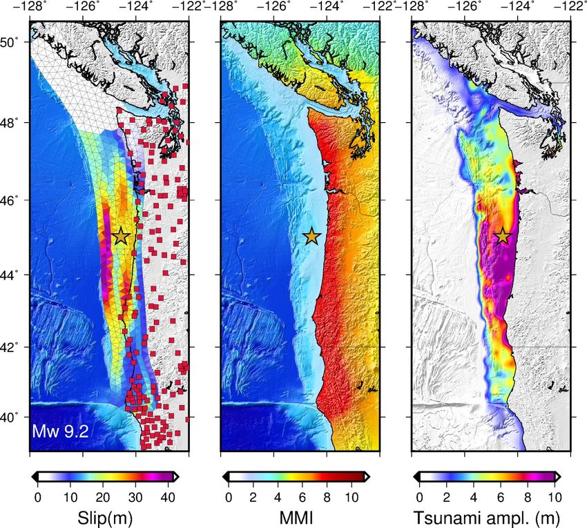
Motivation: Large Magnitude Events Can Be Difficult
  Earthquakes with M>7.5 are very challenging for
 seismic-only systems
  Magnitude saturation means the shaking/tsunami
 alert will not cover as wide an area as necessary
  One solution is to use GPS as part of the system as
 well.
      Predicted shaking         Observed shaking

  No warning!

                                                        Hoshiba et al. (2012)
Motivation: Large Magnitude Events Can Be Difficult
  Earthquakes with M>7.5 are very challenging for
 seismic-only systems
  Magnitude saturation means the shaking/tsunami
 alert will not cover as wide an area as necessary
  One solution is to use GPS as part of the system as
 well.

 Predicted tsunami          Final tsunami

                                                        Hoshiba et al. (2012)
How are we using GNSS data operationally
                                                                   USGS NEIC: We have built server-side
                                                                   tools for the NEIC to access and
                                                                   manipulate the data on the left and
                                                                   model earthquakes. Plan to add this
                                                                   information to event overview pages.
                                                                   Event based and single station queries,
                                                                   PGD analysis, W-phase, finite fault
                                                                   inversions.

                                                                   ShakeAlert: GFAST PGD magnitude
                                                                   module is being incorporated, should be
                                                                   operational in < 1 year.

                                                                   NOAA TWCs: GFAST is being added to
                                                                   SIFT to merge the geodetic slip
                                                                   estimates to tsunami inundation in the
 Current RT-GNSS positions available on PNSN server this morning   near-field. Four-year NASA Disasters
 1420 stations with 5-day data buffer, latency ~2 s                project.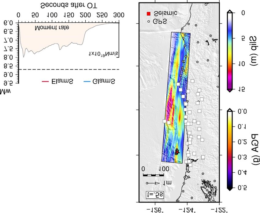
How do we apply this information?

                                             Peak ground
                                             displacements:
                                             magnitude

                                             Coseismic offsets:
                                             CMT, slip inversion,
                                             magnitude

                                             Impact Modeling:

                                             Ground Motions
                                             Tsunami Inundation

                                    Melgar et al. (2013)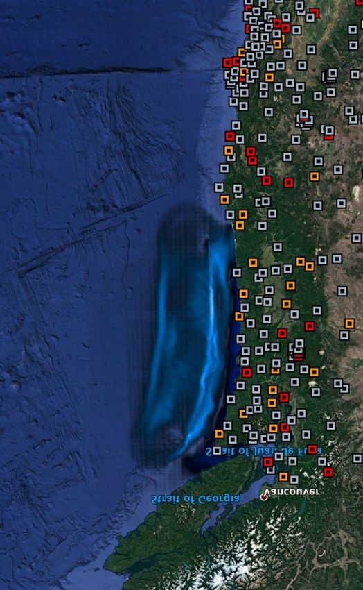
How do we apply this information currently?
                                         When 4 stations are
                                         available, a magnitude
                                         and source is estimated
                                         by G-FAST

                                         This estimate is fed into
                                         tsunami propagation
                                         codes, which will then
                                         inform a watchstander of
                                         the tsunamigenic potential
                                         of an earthquake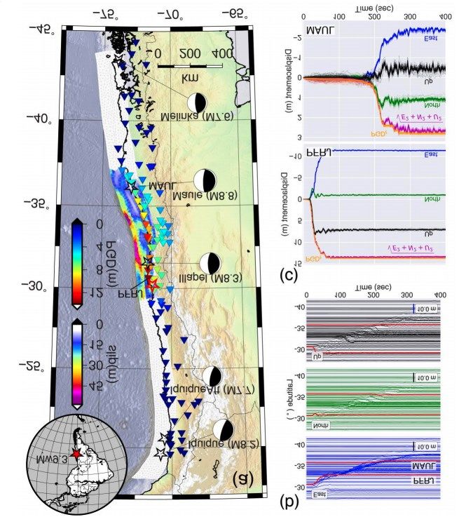
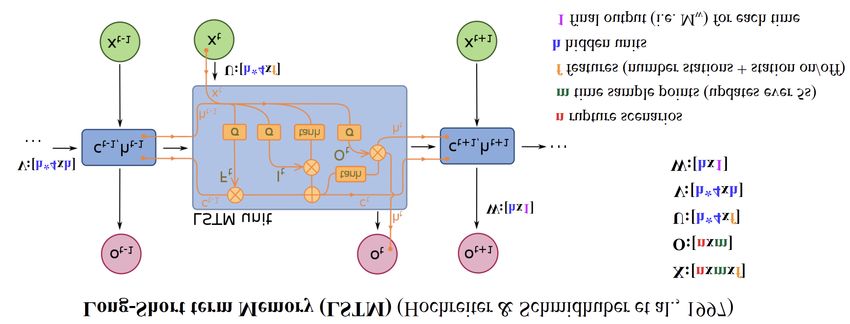
From G-FAST Finite Fault to Tsunami Prediction

    Input Model at 3 minutes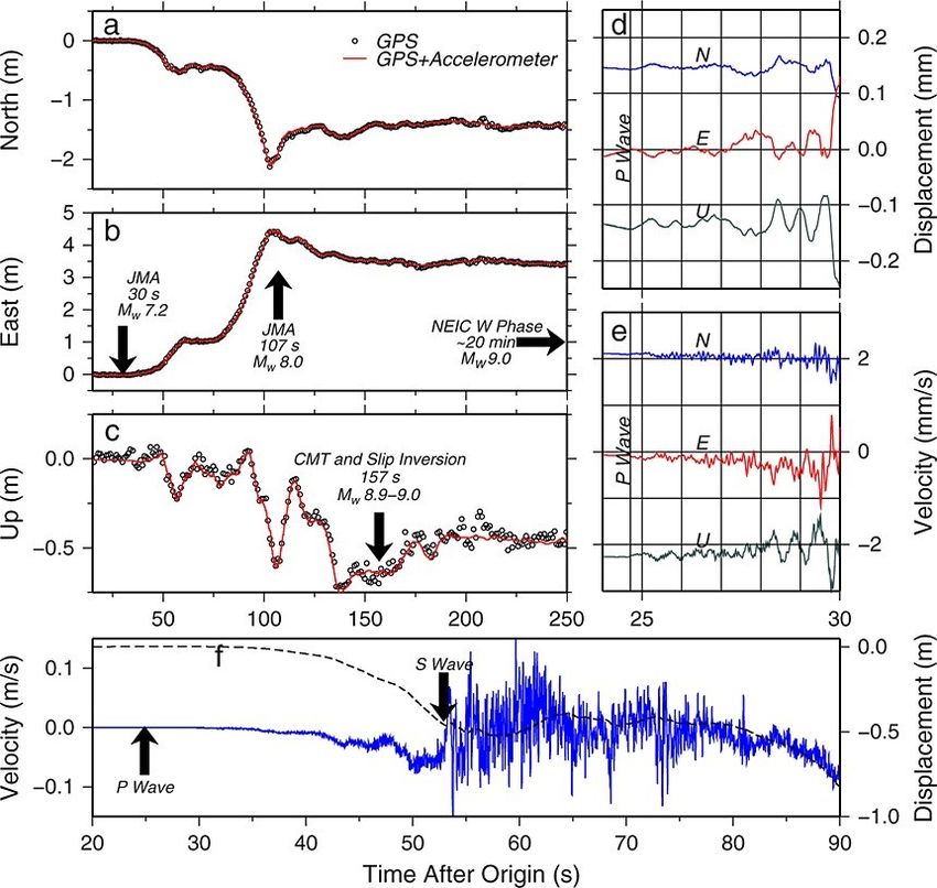
Recurent Neural Networks

 Magnitude                 Magnitude         Magnitude
   at 5s                    at 10s            at 15s

                                                         Displacement (m)
                     Hochreiter & Schmidhuber,
                                                                            Lin et al., in review
                                1997

 GNSS at 5s GNSS at 10s                   GNSS at 15s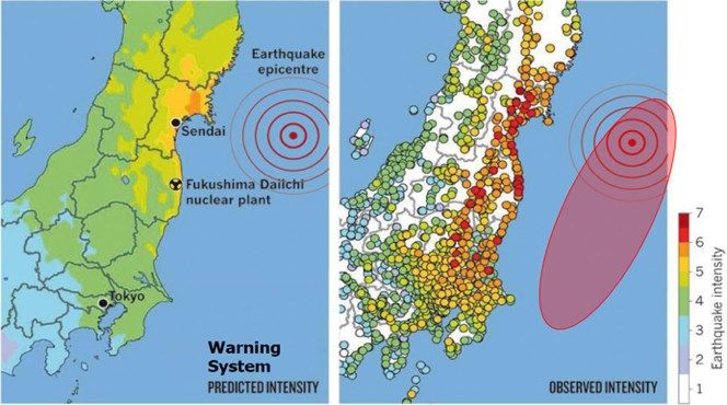
Using RNN to Predict Final Magnitude
Where to next? M-LARGE 2.0
  Predict the extent of faulting (the rupture polygon)
  This is the most important thing for forecasting
  shaking in real-time
  Magnitude           Centroid         Centroid
                     longitude         Latitude

  Centroid           Fault length     Fault width
   Depth
Where to next: Who cares about the earthquake? Who cares about the earthquake? ๏ The GNSS data encodes (most of) the potential earthquake and tsunami hazards ๏ From the crustal deformation patterns predict shakemaps the tsunami amplitudes at the coast without characterizing the earthquake
Where to next: Who cares about the earthquake?
Mw 8.91                Mw 9.24
          1.0m                    2.0m
           3m                      5m

126˚ −124˚ −122˚ −128˚ −126˚ −124˚ −122˚
Conclusions
• GNSS-based earthquake and tsunami early warning is currently in
the production phase at USGS and prototype phase at NOAA
• Our current method relies upon traditional techniques, i.e., use a
physics-based approach to invert for the earthquake rupture using
the displacements recorded.
• ML approaches can help in most aspects of early warning, from the
data processing, to the source inference, to the impact modeling.
• The framework exists to test ML approaches within G-FAST without
disrupting the existing modeling modules.You can also read