Réseau électrique métropolitain (REM) - CDPQ Infra Inc
←
→
Page content transcription
If your browser does not render page correctly, please read the page content below
Réseau électrique         CDPQ Infra Inc
métropolitain (REM)

REM Summary Forecasting   Our ref: 22951101
Report                    Client ref: BC-A06438
November 2016
Réseau électrique                                     CDPQ Infra Inc
métropolitain (REM)

REM Summary Forecasting                               Our ref: 22951101
Report                                                Client ref: BC-A06438
November 2016

Prepared by:                                          Prepared for:

Steer Davies Gleave                                   CDPQ Infra Inc
Suite 970 - 355 Burrard Street                        1000 Place Jean-Paul-Riopelle
Vancouver, BC V6C 2G8                                 Montréal QC H2Z 2B3
Canada

+1 (604) 629 2610
na.steerdaviesgleave.com

Steer Davies Gleave has prepared this material for CDPQ Infra Inc. This material may only be used within the
context and scope for which Steer Davies Gleave has prepared it and may not be relied upon in part or whole
by any third party or be used for any other purpose. Any person choosing to use any part of this material
without the express and written permission of Steer Davies Gleave shall be deemed to confirm their
agreement to indemnify Steer Davies Gleave for all loss or damage resulting therefrom. Steer Davies Gleave
has prepared this material using professional practices and procedures using information available to it at the
time and as such any new information could alter the validity of the results and conclusions made.
Contents

1   Introduction ............................................................................................................................. 1
    Report Structure ................................................................................................................................. 1
    Disclaimer ........................................................................................................................................... 2

2   Project Definition ..................................................................................................................... 3
    Alignment and Stations ...................................................................................................................... 3
    Park and Ride ...................................................................................................................................... 6
    Rail Network Reorganisation .............................................................................................................. 7
    Bus Network Reorganization .............................................................................................................. 7
    Fare Assumptions ............................................................................................................................... 8

3   Current situation ...................................................................................................................... 9
    Background ......................................................................................................................................... 9
    South Shore/A10 Market .................................................................................................................... 9
    West Island/Deux-Montagnes Line Market...................................................................................... 12
    Aéroport Pierre-Elliott-Trudeau Market ........................................................................................... 15
    Existing Fares .................................................................................................................................... 17

4   Modelling approach................................................................................................................ 20
    Model overview ................................................................................................................................ 20
    Network development...................................................................................................................... 21
    Corridor Demand Choice Models ..................................................................................................... 22
    Airport model ................................................................................................................................... 24
    Expansion factors.............................................................................................................................. 26
    Ramp up ............................................................................................................................................ 27

5   Demand Development ............................................................................................................ 28
    2015 Base Year Demand ................................................................................................................... 28
    Demand Growth ............................................................................................................................... 29
    Future Transit Matrix Development ................................................................................................. 33
    Auto Future Matrix Development .................................................................................................... 34

                                                                                                                                          November 2016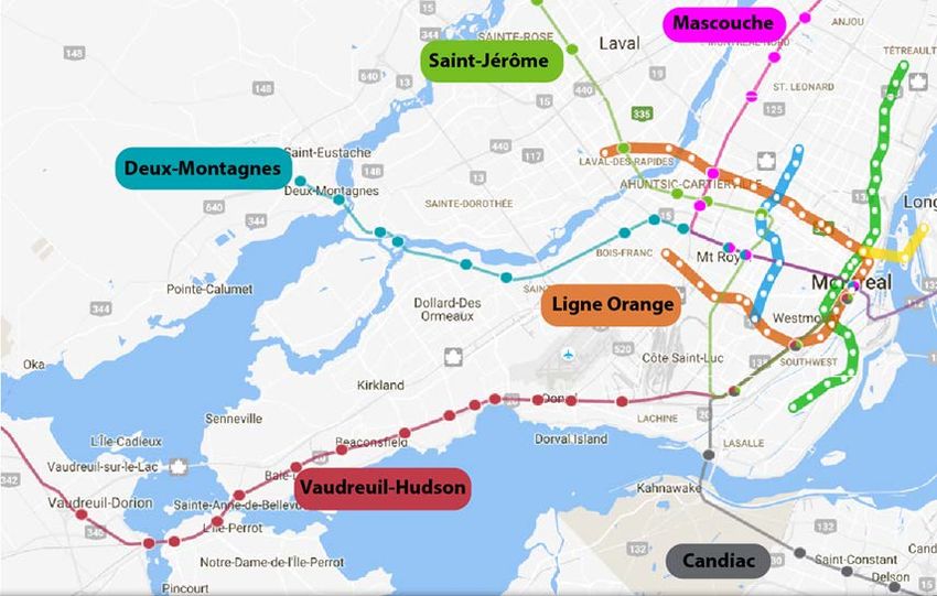
6   Model Calibration................................................................................................................... 35
    Traffic Model .................................................................................................................................... 35
    Transit Model.................................................................................................................................... 37

7   REM Forecasting ..................................................................................................................... 41
    Sponsor Case Definition.................................................................................................................... 41
    Sponsor Case Forecast Overview (2015) .......................................................................................... 43
    Sponsor Case Forecasts (2021 and 2031) ......................................................................................... 45

8   Sensitivity Tests ...................................................................................................................... 53
    Identified risks .................................................................................................................................. 53
    Low and High Case Definition ........................................................................................................... 53
    Ridership Forecasts ........................................................................................................................... 55

    Figures
    Figure 2.1: REM Network .................................................................................................................... 3
    Figure 3-1: St Lawrence River Crossings ........................................................................................... 10
    Figure 3-2: St Lawrence River crossing transit alternatives.............................................................. 11
    Figure 3-3: West Island auto screenlines.......................................................................................... 13
    Figure 3-4: West Island rail and Metro network .............................................................................. 14
    Figure 3.5: AMT Fare Zone Map (August 2016) ................................................................................ 18
    Figure 4.1: Forecasting Model Overview .......................................................................................... 20
    Figure 4.2: Transit services coded by mode ..................................................................................... 22
    Figure 4.3: Weekday to Annual Expansion Analysis ......................................................................... 27
    Figure 5.1: West Island/Deux-Montagnes Line transit ridership and socio-economic parameters
    growth............................................................................................................................................... 30
    Figure 5.2: West Island/Deux-Montagnes Line Growth Model Results ........................................... 30
    Figure 5.3: South Shore/A10 boardings and socio-economic parameters growth .......................... 31
    Figure 5.4: South Shore/A10 Growth Model Calibration ................................................................. 32
    Figure 5.5: ADM airport growth forecast ......................................................................................... 32
    Figure 6.1: Deux-Montagnes Line Load Profile – AM Peak towards Montréal ................................ 38

                                                                                                                                          November 2016
Figure 6.2: Deux-Montagnes Line Load Profile – Inter Peak towards Montréal .............................. 38
Figure 6.3: Deux-Montagnes Line Load Profile – Inter Peak from Montréal.................................... 39
Figure 6.4: West Island Transit boarding calibration – AM Peak Average Hour .............................. 39
Figure 6.5: West Island Transit boarding calibration – Inter Peak Average Hour ............................ 40
Figure 6.6: South Shore/10 Transit Calibration ................................................................................ 40
Figure 7.1: Annual Ridership Profile (with ramp up) ........................................................................ 51
Figure 7.2: Annual Passenger Kilometre Profile (with ramp up) ...................................................... 52
Figure 8.1: Annual boardings – Low and High Cases (with ramp up) ............................................... 56
Figure 8.2: Annual Passenger Kilometres – Low and High Case (with ramp up) .............................. 56

Tables
Table 2.1: REM stations and travel times ........................................................................................... 4
Table 2.2: REM Operating Assumptions ............................................................................................. 5
Table 2.3: Park and Ride Assumptions ............................................................................................... 6
Table 3-1: 2013 St Lawrence River crossing traffic volumes ............................................................ 10
Table 3-2: South Shore/A10 corridor/Champlain Bridge demand (October weekday in 2015) ...... 12
Table 3-3: South Shore Park & Ride spaces and occupancy (2015).................................................. 12
Table 3-4: West Island corridor traffic demand (2013) .................................................................... 13
Table 3-5: AMT average ridership (2015) ......................................................................................... 14
Table 3-6: West Island Bus Demand (October 2015 weekday) ........................................................ 15
Table 3.7: West Island/Deux Montagnes Park & Ride sites ............................................................. 15
Table 3.8: 2015 In-scope airport passenger demand by market segment- AM peak and Interpeak
periods .............................................................................................................................................. 17
Table 3.9: AMT Average Fares (2015 $) ............................................................................................ 18
Table 3.10: Average Fares per trip – CIT (2015 $) ............................................................................ 19
Table 3.11: Average Fare – STM (2015 $) ......................................................................................... 19
Table 4.1: Corridor SP results ........................................................................................................... 23
Table 4.2: Generalized Cost components for existing modes .......................................................... 25
Table 4.3: Airport SP results summary ............................................................................................. 26

                                                                                                                                      November 2016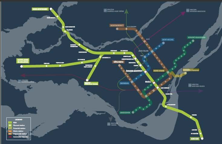
Table 4.4: Expansion Factor Analysis ................................................................................................ 26
Table 4.5: Ramp Up Factors .............................................................................................................. 27
Table 5.1: MOTREM Demand Total (2016) ....................................................................................... 28
Table 5.2: Demand data source summary ........................................................................................ 29
Table 5.3: Socio-economic variables and forecasts .......................................................................... 33
Table 5.4: Transit ridership growth estimates .................................................................................. 33
Table 5.5: Transit demand matrices by forecast year ...................................................................... 34
Table 6.1: Bridge Crossing Auto Screenline ...................................................................................... 36
Table 6.2: West Island Auto Screenline ............................................................................................ 37
Table 7.1: Sponsor Case Project Definition ...................................................................................... 41
Table 7.2: Sponsor Case Model Assumptions ................................................................................... 42
Table 7.3: REM Demand captured by Market(2015) ........................................................................ 43
Table 7.4: REM transit shift capture (2015)...................................................................................... 43
Table 7.5: REM Airport Demand Capture (2015).............................................................................. 43
Table 7.6: REM Car shift capture (2015) ........................................................................................... 44
Table 7.7: 2015 AM Peak and Inter Peak REM Boardings ................................................................ 44
Table 7.8: AM Peak and Inter Peak REM Boardings ......................................................................... 45
Table 7.9: AM and Inter Peak Station Boardings and Alightings (2021 and 2031) ........................... 46
Table 7.10: Demand loads per line section ...................................................................................... 48
Table 7.11: REM Station Boardings (Daily and Annual) .................................................................... 49
Table 7.12: REM Daily and Annual Boardings (no ramp up)............................................................. 50
Table 7.13: REM Annual Passenger-Kilometres (no ramp up).......................................................... 50
Table 7.14: Ramp up ......................................................................................................................... 51
Table 7.15: REM Ridership and Passenger Kilometre Summary (with ramp up) ............................. 51
Table 8.1: Sensitivity test definition ................................................................................................. 54
Table 8.2: Ramp Up Assumptions – Low and High Case................................................................... 55
Table 8.3: Low and High Case Comparison....................................................................................... 57
Table 8.4: Low and High Case Peak Loads ........................................................................................ 57

                                                                                                                               November 2016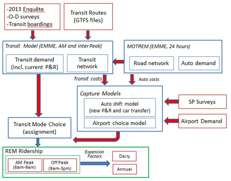
1     Introduction
1.1   Steer Davies Gleave was appointed by CDPQ Infra Inc. to develop investment grade forecasts for
      the Réseau Electrique Métropolitain system (REM), a 67 kilometre light rail network in
      metropolitan Montréal. This report represents the summary of the Forecasting Report dated
      November 2016.
      Report Structure
1.2   Following this introduction, this report includes the following:
      •   Section 2 describes the proposed REM project and plans for reorganising the bus and rail
          services in the REM corridor including proposed P&R sites at REM stations;
      •   Section 3 presents the current transport situation in Montréal and defines the 3 in-scope
          markets for REM: South Shore (Rive-Sud); West Island; and, Montréal-Trudeau Airport;
      •   Section 4 explains our modelling approach, the existing models and bespoke models prepared
          for this study;
      •   Section 5 describes how we have constructed the 2015 base year demand for the existing in-
          scope ridership, historic growth of public transport ridership in Montréal and future demand
          growth models;
      •   Section 6 presents the model calibration, that is, how well the model simulates reality in
          terms of demand by transport mode and travel times in 2015;
      •   Section 7 shows the REM reference case forecasts for 2015 (assuming the system was in place
          today), 2021 and 2031;
      •   Section 8 describes the identified risk and the results of sensitivity tests undertaken on the
          forecasts; and

                                                                                          November 2016 | 1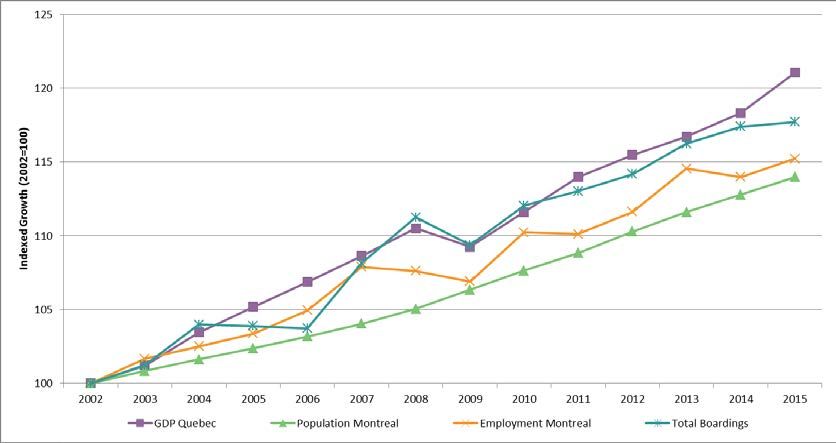
Disclaimer
This document is solely for the benefit of CDPQ Infra. No other person or entity may rely upon this
document without the prior written consent of Steer Davies Gleave which may be granted or
withheld in the Company’s sole discretion.
This document contains projected information and data (financial and otherwise), and other
forward-looking information, that may or may not occur or prove to be accurate. Such projected
and forward-looking information is based on current expectations and projections about future
events, many of which are beyond the control of the Company, the Client or any other participant
in the Project, and such projections and forward-looking information can be affected by inaccurate
assumptions. The projections and forward-looking information were prepared in good faith, but no
assurance can be given as to the accuracy or adequacy of such projections and forward-looking
information, or the assumptions underlying such projections and forward-looking information.
This document speaks only as of the date thereof and the Company does not undertake any
responsibility for updating this document for any reason, including as a result of new information,
future events or otherwise.

                                                                                      November 2016 | 2
2 Project Definition
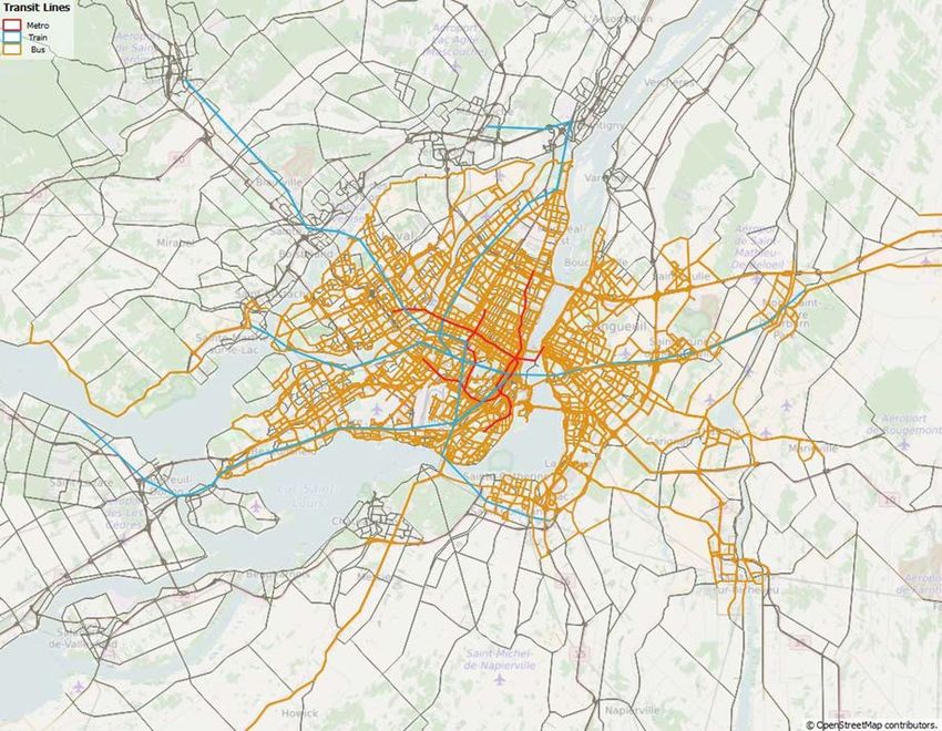
Alignment and Stations
2.1 REM will be a fully automated transportation system, 67 km long, which will provide access to 24
stations. Figure 2.1 shows the extent of the REM network.
Figure 2.1: REM Network
2.2 With a frequent and reliable service running from 5:00 am to 1:00 am – 20 hours a day, every day
– REM will provide a significantly enhanced travel experience for commuters and non-commuters
in the Montréal metropolitan region.
2.3 REM will provide services to those stations currently served by the Deux-Montagnes AMT Line and
it will substantially increase rail coverage with new stations in Rive-Sud, Sainte-Anne-de-Bellevue
and Aéroport Pierre-Elliott-Trudeau areas. Moreover, the dedicated tracks will allow for quick and
November 2016 | 3uninterrupted travel and passengers will enjoy substantial travel time savings. The location of the
stations and the travel times between stations are shown in Table 2.1.
Table 2.1: REM stations and travel times
Travel time
Station Station Distance (m)* Speed (km/h)
(mins)
DEUX-MONTAGNES
Gare Centrale Canora 5,410 05:05 64
Canora Mont-Royal 820 01:30 33
Mont-Royal Correspondance A40 1,470 01:58 45
Correspondance A40 Montpellier 940 01:37 35
Montpellier Du Ruisseau 1,460 02:00 44
Du Ruisseau Bois-Franc 1,720 02:07 49
Bois-Franc Sunnybrooke 6,390 05:13 73
Sunnybrooke Roxboro-Pierrefonds 2,170 02:50 46
Roxboro-Pierrefonds Île-Bigras 3,450 02:58 70
Île -Bigras Sainte-Dorothée 930 01:42 33
Sainte-Dorothée Grand-Moulin 2,700 02:47 58
Grand-Moulin Deux-Montages 2,200 02:33 52
Total 29,660 32:20 55 (average)
RIVE-SUD
Gare Centrale Île-des-Soeurs 5,050 04:57 61
Île-des-Soeurs Panama 5,410 04:36 71
Panama Du Quartier 3,670 03:20 66
Du Quartier Rive-Sud 1,030 01:34 55
Total 15,570 14:27 65 (average)
SAINTE-ANNE-DE-BELLEVUE
Bois-Franc Autoroute 13 4,440 03:58 67
Autoroute 13 Des Sources 3,780 03:25 66
Des Sources Pointe-Claire 4,130 03:42 67
Pointe-Claire Kirkland 2,580 02:49 55
Kirkland Sainte-Anne-de-Bellevue 4,280 03:45 68
Total 19,210 17:39 65 (average)
AÉROPORT PIERRE-ELLIOTT-TRUDEAU
Autoroute 13 Technoparc Saint-Laurent 2,500 02:55 51
Technoparc Saint-Laurent Aéroport Pierre-Elliott-Trudeau 2,780 02:53 58
Total 5,280 5:48 55 (average)
TOTAL 67,200 70:14 60 (average)
Note: Dwell time assumed is 30 seconds for all stations except for Gare Centrale and Panama where it is 40 seconds
*The total distance accounts for double tracking
November 2016 | 42.4 REM will provide enhanced frequencies to the Deux-Montagnes corridor (services every 12
minutes) compared to the existing AMT rail service. It will also introduce very frequent services to
the Rive-Sud area (every 2 minutes and 40 seconds) replacing the existing express bus services on
the Champlain Bridge. It will also include new rail services to the Aéroport Pierre-Elliott-Trudeau
and Sainte-Anne-de-Bellevue (every 12 minutes respectively), which will provide an alternative to
the existing express bus services and other local services feeding the Orange Metro line. Table 2.2
shows the key frequency assumptions.
Table 2.2: REM Operating Assumptions
Route Headway (mins) Travel time (mins)
AM (6am-9am) Inter Peak (9am-3pm)
Deux-Montagnes to Rive-Sud 12 15 46:47
Roxboro-Pierrefonds to Rive-Sud 12 - 36:47
Sainte-Anne-de-Bellevue to Rive-Sud 12 15 46:23
Aéroport Pierre-Elliott-Trudeau to Rive-Sud 12 15* 38:30
Correspondance A40 to Rive-Sud** 20 - 23:00
2mins 40sec. 5 mins
From From Gare Centrale to
Peak Headways per period -
Correspondance A40 Rive-Sud
to Rive-Sud
*Inter Peak service from Aéroport Pierre-Elliott-Trudeau is express from Bois-Franc to Gare Centrale
** In the AM peak it is assumed a new additional service from Correspondance A40 to cover the demand alighting from
the Mascouche Line service
2.5 In summary, REM will not only provide an additional service to critical corridors in the
Métropolitan area (Deux-Montagnes, Rive-Sud, Sainte-Anne-de-Bellevue and Aéroport Pierre-
Elliott-Trudeau), but it will also provide a new alternative to the Métro Orange Line to access
Downtown Montréal.
November 2016 | 5Park and Ride
2.6 Another change brought about as a result of the introduction of the REM network is changes to
the Park & Ride provision. Table 2.3 provides a summary of the current and future Park & Ride
provision for the REM network.
Table 2.3: Park and Ride Assumptions
Stations Current Capacity REM Capacity
Gare Centrale 0 0
Canora 0 0
Mont-Royal 0 0
Correspondance A40 - 0
Montpellier 0 0
Du Ruisseau 1,063 1,060
Bois-Franc 742 740
Sunnybrooke 515 400
Roxboro-Pierrefonds 918 1,040
Île-Bigras 65 45
Sainte-Dorothée 1,101 975
Grand-Moulin 304 230
Deux-Montagnes 1,256 1,160
Île-des-Soeurs - 0
Panama 962 700
Du Quartier - 0
Rive-Sud - 3,000
Autoroute 13 - 500
Des Sources - 500
Pointe-Claire - 700
Kirkland - 500
Sainte-Anne-De-Bellevue - 2,000
Technoparc Saint-Laurent - 0
Aéroport Pierre-Elliott-Trudeau - 0
TOTAL 6,926 13,550
November 2016 | 6Rail Network Reorganisation
2.7 The introduction of REM will result in the following changes to the rail network:
• Deux-Montagnes existing rail service will cease to operate and will be replaced by the REM
• Mascouche Line service will be terminated at Correspondance A40 station and will cease to
provide service to Gare Centrale. An additional REM service from A40 has been introduced in
the operating plan in order to cover this demand and ensure full integration and capacity of
the system (see Table 2.2).
Bus Network Reorganization
2.8 The introduction of REM will be complemented with a full reorganization of the transit network in
the South Shore/A10 and the West Island/Deux-Montagnes Corridors. The extent of the bus
reorganization has been defined by the Agence métropolitaine de transport (AMT) in
collaboration with the various Conseil intermunicipal de transport (CITs) and Société de transport
de Montréal (STM) in order to optimize the system by avoiding duplication of services, and
increasing the network coverage and service levels. This section summarizes the future bus
network reorganization assumptions.
A-10 Corridor/South Shore
2.9 The South Shore bus network reorganisation is based on assumptions developed by AMT in
February 2016. The main objective of the reorganization is to truncate all express bus services that
currently cross the Champlain Bridge, in order not to duplicate services and eliminate bus traffic
on the Bridge. The approach adopted by AMT was to terminate these services in the most
accessible REM station.
West Island/Deux-Montagnes Line
2.10 Assumptions regarding the West Island bus network reorganisation are based on the preliminary
assumptions provided by STM in September 2016. The approach was to develop a new feeder bus
system for the West Island that avoids duplication of services and is better integrated with the
REM.
2.11 The following summarizes Steer Davies Gleave’s understanding of the STM proposed bus network
reorganisation:
• Most routes are maintained with some alignment modifications that better serve existing
communities and feed the REM service.
• 17 services are deleted (8 of them are express services) and 14 new services are created.
These new services directly feed REM.
• For most of the remaining services, levels of service during peak periods increase and stay
relatively the same during the inter peak.
• Levels of service for the new routes during the peak period are high and similar to current
express services headways (lower than 12 minutes and average of 8 minutes).
2.12 STM also operates 747 Express Airport Shuttle. However, it has not provided any assumption for
the level of service when the REM starts operation, which will have a significant impact in
November 2016 | 7ridership on the Aéroport Pierre-Elliott-Trudeau branch. For the base case, as requested by the
client, it has assumed that this service will be eliminated from service.
Fare Assumptions
2.13 It is expected that the current fare structure will remain in place and the REM will be fully
integrated into Greater Montréal’s fare structure.
2.14 The only major modification would be related to the REM airport branch, where fares have been
assumed to be $5 higher compared to the current 747 average fare.
November 2016 | 83 Current situation
Background
3.1 The REM project will transform the transit offer in the Greater Montréal Area, by providing a new
efficient, frequent and reliable service between the South Shore, Downtown Montréal, the West
Island, City of Deux-Montagnes and the Aéroport Pierre-Elliott-Trudeau (ADM).
3.2 Although REM will be fully integrated, it will service three very different markets:
• South Shore/A10: clearly dominated by a commuting demand which is very high in the AM
peak in the Montréal direction. This demand is currently served by express bus services that
cross the Champlain Bridge using dedicated bus lanes.
• West Island/Deux-Montagnes Line: similar to the above, this is a very strong commuting
market. However this demand is served by a variety of services, including rail services and
express and local bus services that feed the Orange Line into Montréal.
• Airport: very specific demand driven by the Aéroport Pierre-Elliott-Trudeau activity, with a
flatter daily profile and peak in the afternoon between 3pm and 6pm.
South Shore/A10 Market
3.3 The REM will provide a frequent and reliable rail link between the South Shore and Downtown
Montréal (as well as the rest of the West Island corridor and the airport corridor).
3.4 There is a very strong commuter-driven demand between the South Shore and the Montréal
downtown area, with high peaks in the AM peak towards Montréal and in the PM peak towards
the South Shore. Given the natural barrier of the Saint Lawrence river, the river crossing
alternatives are limited and as a result the A10 is one of the highest demand corridors in the
region for auto and transit users. We describe the existing auto and transit users and current
transport provision in the following sections.
Auto Users
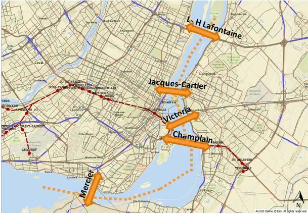
3.5 Figure 3-1 shows the most important five crossings from the South Shore.
November 2016 | 9Figure 3-1: St Lawrence River Crossings
3.6 The Champlain Bridge carries approximately 28% of the total traffic crossing to/from South Shore.
Although there is a strong component of commuting traffic heading to Downtown Montréal
during the AM period, Table 3-1 also shows significant demand levels in the Inter Peak period.
Table 3-1: 2013 St Lawrence River crossing traffic volumes
Screenline 6:00 to 9:00 am 9:00 am to 15:00 pm
Name Direction
Num. (3 hours) (6 hours)
Louis Hippolyte Lafontaine
1 To Montréal 13,364 19,939
tunnel (A25)
From Montréal 11,450 20,830
2 Jacques Cartier Bridge (R134) To Montréal 12,757 13,863
From Montréal 5,530 12,663
3 Victoria Bridge (R112) To Montréal 6,765 4,043
From Montréal - 3,697
4 Champlain Bridge (A10) To Montréal 17,046 17,956
From Montréal 6,750 18,003
5 Honoré Mercier Bridge(R138) To Montréal 7,285 9,040
From Montréal 3,152 8,803
TOTAL To Montréal 57,217 64,841
From Montréal 26,882 63,996
November 2016 | 10Transit Users
3.7 Transit options are also limited to the limited crossings along the St Lawrence River. The key
existing transit options are shown in Figure 3-2.
Figure 3-2: St Lawrence River crossing transit alternatives
A10 corridor
3.8 These 48 routes provide a combined frequency over the Champlain bridge of approximately 200
services in the AM peak hour. However, this frequency drops to approximately 21 services in the
Inter Peak period (9am–3pm), which clearly shows that the service is driven by the commuter
needs of residents of the South Shore.
3.9 These express bus services provide very competitive travel times in the peaks (despite high levels
of congestion on Champlain Bridge) as transit services use segregated bus lanes across the bridge.
As a result, travel times only increase from 19 minutes in the Inter Peak direction to 24 minutes in
the peak direction.
3.10 The competitiveness and convenience of the South Shore/A10 transit corridor has encouraged the
use of transit, presenting very high transit market share compared to other corridors. Table 3-2
presents the demand in the corridor per transit agency and for those bus routes that cross the
Bridge to access Downtown Montréal.
November 2016 | 11Table 3-2: South Shore/A10 corridor/Champlain Bridge demand (October weekday in 2015)
Transit agency Peak (6am-9am) Off-peak (9am-3pm)
RTL 9,557 6,399
AMT 2,768 783
Ville de Saint-Jean-sur-
1,336 958
Richelieu
CITLR 2,025 476
CITVR 149 64
CITCRC 1,577 286
CITROUS 875 214
OMITSJU 481 20
total 18,287 9,180
3.11 Within the South Shore/A10 transit corridor, Park & Ride facilities are provided at the critical
transit interchange stations. Currently Panama and Chevrier stations have a total capacity of 3,275
spaces (see Table 3-3). These facilities are currently free of charge and are typically at full capacity
from early in the AM peak which suggests that there is unsatisfied demand due to parking capacity
constraints.
Table 3-3: South Shore Park & Ride spaces and occupancy (2015)
Location Size Occupancy
Panama 962 100%
Chevrier 2,313 89%
Total 3,275 92%
West Island/Deux-Montagnes Line Market
3.12 The REM will provide a frequent and reliable rail link between the West Island/Deux-Montagnes
Line and Downtown Montréal (as well as the South Shore/A10). It will not only improve the
service currently provided by the Deux-Montagnes Line, but it will also extend its alignment to the
Point Claire and Sainte-Anne-de-Bellevue areas.
3.13 As a result, there is a very strong commuter-driven demand between the West Island/Deux -
Montagnes corridor and the Downtown Montréal area, with high peaks in the AM towards
Montréal and in the PM in the reverse direction.
Auto Users
3.14 The REM line will operate in parallel with the A40 and the A20. Total traffic volumes from the two
screenlines by direction are detailed in Table 3-4. The location of the screenlines is shown in
Figure 3-3.
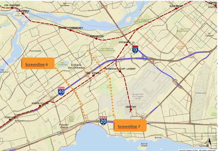
November 2016 | 12Figure 3-3: West Island auto screenlines
Screenline 1
Screenline 2
3.15 Traffic volumes peak between 6am to 9am heading into the Montréal area, as a result of the high
proportion of commuting traffic. Screenline 2, which lies closer to Downtown Montréal displays
significantly higher traffic volumes (approximately twice as high) as Screenline 1.
Table 3-4: West Island corridor traffic demand (2013)
Screenline 1 Screenline 2
Direction
6:00 to 9:00 am 9:00 am to 15:00 pm 6:00 to 9:00 am 9:00 am to 15:00 pm
To Montréal 21,893 26,476 43,385 55,860
Towards West 10,489 23,818 19,424 42,008
Transit Users
3.16 The West Island of Montréal covers a very large area. To cater for this demand, there is an
extensive transit network of; commuting rail (Deux-Montagnes Line and Vaudreuil-Hudson Line)
and bus services, that provide access to Downtown Montréal either directly or via the Orange
Line.
Rail Network
3.17 Figure 3-4 shows the rail and Metro line alignments and stations on the West Island.
November 2016 | 13Figure 3-4: West Island rail and Metro network
3.18 Currently, the Deux-Montagne line (DM) has the highest ridership, with almost 32,000 daily riders.
Table 3-5 shows that most of the rail services have a strong component of commuting demand,
with majority of demand in the peak periods.
Table 3-5: AMT average ridership (2015)
AMT commuter rail 6am-9am 9am-3pm Daily
Deux-Montagnes Line 14,371 4,580 31,835
Vaudreuil-Hudson Line 8,450 1,238 17,588
Mascouche Line 2,421 199 4,905
Saint-Jérôme Line 6,792 1,068 13,709
Source: Agence Métropolitaine de Transport
Bus Network
3.19 STM is the main bus service provider on the West Island. It operates 53 in-scope bus services,
which cover both express and local services with frequencies vary depending on the route
3.20 Table 3-6 presents the demand for each type of bus route and for an average weekday in October
2015. The express routes have higher demand in the peak period, as expected, while the non-
express routes have higher demand in the off-peak period due to shorter trips on these services.
November 2016 | 14Table 3-6: West Island Bus Demand (October 2015 weekday)
Peak (6am- Off-peak
DAILY
9am) (9am-3pm)
Express routes in scope 12,580 10,611 41,403
Non-express routes in scope 42,392 50,902 174,782
747 493 1,730 5,304
Total 55,465 63,242 221,490
Park and Ride Facilities
3.21 In the West Island/Deux-Montagnes Corridor, many of the rail stations currently have Park & Ride
facilities. Stations on the Deux-Montagnes Line provide a total capacity of 5,964 spaces (see Table
3.7). These facilities are currently free of charge and are typically at full capacity from the early
peak hour period (average occupancy of 91%), which suggests that there is unsatisfied demand
due to the capacity constraints of the car parks.
Table 3.7: West Island/Deux Montagnes Park & Ride sites
Deux-Montagnes
Size (and occupancy) Occupancy
Line
Du Ruisseau 1,063 82%
Bois-Franc 742 91%
Sunnybrooke 515 98%
Roxboro–
918 92%
Pierrefonds
Île-Bigras 65 99%
Sainte-Dorothée 1,101 92%
Grand-Moulin 304 96%
Deux-Montagnes 1,256 92%
Total 5,964 91%
Aéroport Pierre-Elliott-Trudeau Market
3.22 The REM will provide frequent and reliable access to/from Aéroport Pierre-Elliott-Trudeau for air
passengers and staff travelling from the South Shore, Downtown Montréal, the West Island and
Deux-Montagnes. At the moment, the majority of people drive and park at the airport. There is
also a significant number of people who are driven to the airport either by a friend/family member
or in a taxi.
3.23 The only current public transport option is the 747 bus route operated by STM. The 747 service
runs 24 hours a day, 7 days a week, between Aéroport Pierre-Elliott-Trudeau and Berri/UQAM
Métro station, east of Downtown Montréal. Frequencies vary through the day, from one bus every
7-10 minutes to two buses per hour.
November 2016 | 153.24 The total end to end travel time ranges from 45 minutes to 60 minutes, depending on traffic
conditions. Travel times particularly vary on the A20 and on René-Lévesque, the main road
through Downtown Montréal.
Demand
3.25 Demand for travel to the Aéroport Pierre-Elliott-Trudeau includes:
• Aéroport Pierre-Elliott-Trudeau passenger demand; and
• Aéroport Pierre-Elliott-Trudeau staff demand
3.26 Aéroport Pierre-Elliott-Trudeau passenger demand is based on the actual number of air
passengers flying into or out of Aéroport Pierre-Elliott-Trudeau using information directly from
Aéroports de Montréal (ADM).
3.27 The total passenger demand for the airport is estimated to be 15.5 million passengers in 2015.
Clearly not all airport passengers could use REM for their journey to/from the airport. Some
passengers were excluded from our analysis for the following reasons:
• Passengers who are using Aéroport Pierre-Elliott-Trudeau to connect to another flight and do
not leave the Airport (18%).
• Passengers who were arriving/leaving the Aéroport Pierre-Elliott-Trudeau while REM is not in
operation (e.g. in the middle of the night) (7%).
3.28 Airport staff demand has also been calculated using information from ADM. ADM also provided
details of roles and working patterns, which showed that in 2015, 41% of staff worked ‘normal
hours’, 46% worked long shifts and 13% were pilots or cabin crew.
3.29 In order to convert the number of employees in to the number of trips to/from the airport, we
made a number of assumptions and estimated that airport staff made over 8.8 million staff trips
per year in 2015 (our model base year). However, many of those trips are out of the scope of the
REM, and it is estimated that around 1.5m of staff trips are using currently the airport staff
parking facilities.
Distribution of demand
3.30 The airport model includes a number of different levels of segmentation. This allows us to have
different profiles for different types of people. The profiles determine how likely someone is to
switch to REM given their current travel time (which includes walk time, wait time, in vehicle
travel time and fare (if they use public transport).
3.31 Table 3.8 provides a summary of total airport passengers demand by market segment airport
passengers demand by market segment in the AM Peak and Interpeak periods.
November 2016 | 16Table 3.8: 2015 In-scope airport passenger demand by market segment- AM peak and Interpeak periods
Bus Taxi Car Park & Fly Car Kiss & Fly
Time of Day AM peak (6am-
493 1,362 1,072 1,973
9am)
Inter peak (9am-
1,730 3,234 1,502 4,456
3pm)
Journey purpose Business 509 1,824 1,007 922
Non Business 1,715 2,772 1,567 5,507
Residency Non-resident 342 966 57 686
Resident 1,881 3,630 2,517 5,743
Group size Alone 1,917 2,868 1,814 3,743
In a group 306 1,728 760 2,687
Total 2,223 4,596 2,574 6,429
3.32 The main transit access to the Aéroport Pierre-Elliott-Trudeau is the 747 shuttle service. This
service registered an average daily demand of 5,300 passengers for an average weekday in
October 2015 (493 passengers in the AM peak and 1,730 in the interpeak). The peak demand for
this service occurs between 2pm and 5 pm, which partially overlaps with the commuting PM peak.
Existing Fares
3.33 The REM area of influence is covered by Greater Montreal’s integrated ticketing structure, which
allows passengers to use the whole transit network in the Montréal Region. Transit operators
offer a wide variety of products and concessions with fares differentiated by:
• Zones
• Type of user: regular (ordinaire), reduced (réduit) and student (étudiant)
• Mode: for example AMT offers TRAM (Commuter rail, bus and Métro) and TRAIN (Commuter
rail only) tickets
• Products: Tickets are available for different frequency users; daily, weekly and monthly
3.34 In order to estimate the average assumptions are required on the number of trips per ticket type.
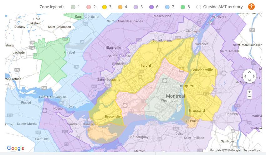
3.35 AMT fares are classified according to a zoning system of 8 zones. Figure 3.5 shows the fare zone
map.
November 2016 | 17Figure 3.5: AMT Fare Zone Map (August 2016)
3.36 Table 3.9 shows the average fare estimated for each zone for adults and students.
Table 3.9: AMT Average Fares (2015 $)
AVERAGE AVERAGE
ZONE ADULT STUDENT
1 $2.01 $1.66
2 $2.38 $1.95
3 $2.77 $2.34
4 $3.02 $2.52
5 $3.47 $2.92
6 $4.14 $3.49
7 $5.19 $4.00
3.37 On the South Shore/A10, more than 50% of the total transit demand that cross the Champlain
Bridge has an origin or destination within AMT fare zone 3. However, for other areas, in addition
to AMT products, there are a number of agencies that also provide products for users that only
use that specific transit agency service (products are not integrated with AMT or STM services).
These are shown below.
November 2016 | 18Table 3.10: Average Fares per trip – CIT (2015 $)
AV
FARE
CITCRC CITVR OMIT-SJU CITROUS CITLR
Zone ADULT STUDENT ADULT STUDENT ADULT STUDENT ADULT STUDENT ADULT STUDENT
4 2.65 2.24
5 3.23 2.78 3.71 2.78 3.42 2.78 2.90 2.58 2.71 2.29
6 3.48 3.28 4.25 3.28 3.69 3.27 3.04 2.99 2.75 2.60
3.38 Table 3.11 shows the average fare estimated for the whole Montréal Island and by ticket type.
Table 3.11: Average Fare – STM (2015 $)
Av Fare Monthly Hebdo single 2 trips 10 trips TOTAL
Adult $1.58 $2.10 $3.21 $2.93 $2.35 $1.93
Student $1.02 $1.29 - - - $1.03
3.39 The STM 747 service is the only service that has a different fare structure. The average fare is
$3.15, which has been calculated based on ticket type sales and usage data provided by STM.
November 2016 | 194 Modelling approach
Model overview
4.1 An overview of the forecasting model framework is shown below.
Figure 4.1: Forecasting Model Overview
November 2016 | 204.2 To support all models, a road and transit network has been developed including the following
features:
• Base year (2015) and two future years (2021 and 2031)
• Two time periods
• AM Peak: 6 to 9am
• Inter Peak: 9am to 3pm
Network development
Road Network
4.3 In order to characterize the existing road network, the team has used the MOTREM model, a road
transportation model developed for the Montréal region, using the EMME software platform.
MOTREM is owned and maintained by MTQ and it was provided to CDPQ for the purposes of this
study.
4.4 MOTREM is disaggregated geographically into 1,766 traffic zones. MOTREM includes auto Origin-
Destination (OD) demand matrices for the zones identified above for the base and future years
(2008, 2016, 2021 and 2031). The demand matrices are split into four vehicle types; cars,
commercial cars, light goods vehicles and heavy good vehicles.
4.5 The model road network is represented as nodes, links and zones. Links contain network
information such as the number of lanes per direction and the volume delay function (vdf). This
function estimates the average speed on that particular link depending on the volume of traffic-
and could be different depending on the road characteristics, maximum speed limit, etc.
4.6 MOTREM assigns auto and goods vehicle demand to the road network via a series of iterations
designed to reach convergence or equilibrium based on the Generalized Costs which account for
travel time, operating costs and tolls (on the A25 and A30 and not very relevant to REM).
Future Road network
4.7 MOTREM includes a number of road network changes. Of particular interest to this project are the
following:
• Champlain Bridge replacement: construction of new 6 lane bridge across the St Lawrence
River and access roads to replace existing bridge (currently under construction)
• Turcot Interchange: reconstruction of the interchange for Highways 15, 20 and 720. This
includes the introduction of reserved bus lanes along Highway 20 (between the St-Pierre and
Turcot Interchanges), inside lane of the Ville-Marie in the eastbound direction and the new
Pullman Boulevard.
Transit Network
4.8 MOTREM only represents the road network relevant to auto users and it has been necessary to
incorporate all the transit network links (rail and Métro) and transit services. Rail and Métro lines
have been coded as separate links and stations have been ‘connected’ to the street network as
required.
November 2016 | 214.9 Transit service route GTFS files were downloaded from the different transit agencies in the
Montréal region and imported as transit routes to EMME. 852 transit routes were coded into
EMME.Figure below shows a plot with the transit services by mode.
Figure 4.2: Transit services coded by mode
Corridor Demand Choice Models
Model Overview
4.10 In order to estimate REM, future demand and capture from alternative modes for the “corridor”
demand, two separate choice models have been developed.
• Auto shift model: estimates the demand that shifts from auto to REM
• Transit mode choice model: estimates the redistribution of demand between the different
transit modes (bus, rail, Métro and REM).
Generalized Cost
4.11 The key attributes for transit users include:
• Fare of the trip (in Canadian Dollars)
• In-vehicle travel time (in minutes)
• Access/egress time (in minutes)
• Waiting time (in minutes)
• Transfer time (in minutes)
November 2016 | 22• Perceived quality of the service: There are intrinsic and intangible benefits perceived by
passengers between rail-based modes and conventional bus related to the quality and
reliability of the service.
4.12 The attributes included to estimate the Generalized Costs of P&R users are the same parameters
as those described for transit users, but it also includes the auto travel times and costs associated
with accessing the P&R station. The monetary costs include fuel and parking costs (if applicable).
4.13 The attributes used to estimate the Generalized Costs of Auto users include travel time, fuel,
parking and tolls.
4.14 Given that some of the Generalized Cost components are measured in time and others in
monetary values, the value of time (VoT) is used to homogenize the different costs in the same
units (minutes or CAD$). The value of time provides an indication of how much an individual is
prepared to pay in order to save a given amount of journey time.
Generalized Cost Parameters
4.15 In order to assess the specific model parameters (values of times, weights and mode preference)
associated with the different users in the corridor, a number of Stated Preference surveys were
carried out by Steer Davies Gleave in May and June 2016.
4.16 Respondents were presented with 8 cards with different hypothetical scenarios where REM was
compared to other modes. These scenarios were designed for each individual respondent based
on their existing trip patterns (Origin/Destination, mode used and existing trip travel time). The
behaviour parameters and value of time for each type of user were estimated based on the
responses to these scenarios.
4.17 Table 4.1 shows the behaviour parameters extracted from the SP analysis.
Table 4.1: Corridor SP results
Parameter Transit Users Car Users
VoT Work $7.37 $14.85
VoT Non-work $7.91 $14.85
Access time factor 1.6 2.7
Wait time factor 1.6 1.8
Transfer Penalty +4 min
REM with transit access (vs
REM vs Rail/Métro: +11 Car): +21 min
Mode penalties min
REM with Park & Ride (vs Car):
REM vs Bus: +6 min
+4 min
November 2016 | 23Airport model
Model Overview
4.18 The airport model is a standalone spreadsheet model, which estimates the level of demand that
will switch to REM from each of the existing modes (Bus, Car Park and Fly, Car Kiss and Fly and
Taxi).
4.19 REM capture is calculated by comparing the Generalized Cost for travel using the existing mode
with the Generalized Cost for travel using REM. Generalized cost includes:
• Walk time
• Wait time (which for transit includes any interchange time)
• In-vehicle time
• Fare or parking charge
4.20 Airport passenger and staff demand has been estimated and distributed by market segment using
the assumptions in Section 3, (see Table 3.8 for the distribution of in-scope demand by market
segment). A binary choice model is then used to understand how each market segment reacts to
the change in Generalized Cost when comparing their existing mode to REM. The greater the
Generalized Cost advantage of REM compared with the existing mode, the more capture is likely
to be abstracted.
4.21 REM capture is calculated for an average hour in the AM peak (6-9 am) and an average hour in the
Inter Peak (9-3pm).
Generalized Cost components
4.22 Table 4.2 shows the Generalized Cost components for each mode and their source.
November 2016 | 24Table 4.2: Generalized Cost components for existing modes
Source
Walk Time Bus Varies for each trip Estimated in Transit Mode Choice model
Taxi 0 minutes
Car (Park & Fly) 10 minutes Based on data on car parks on ADM website.
Car (Kiss & Fly) 0 minutes
Wait Time Bus Varies for each trip Estimated in Transit Mode Choice model
Taxi 0 minutes Assumed no wait time.
Car (Park & Fly) 10 minutes Based on data on car parks on ADM website.
Car (Kiss & Fly) 0 minutes Assumed no wait time.
In-vehicle Time Bus Varies for each trip Estimated in Transit Mode Choice model
Taxi
Same times for all of
Car (Park & Fly) Estimated in Network Model
these modes.
Car (Kiss & Fly)
Fare Bus Varies for each trip Estimated in Transit Mode Choice model
$40 fixed downtown fare Based on Steer Davies Gleave online research of
Taxi
$4.86 + $1.7 per km standard taxi fares in Montréal
Passenger charge based on an assumed average
$140 parking charge for 9 nights stay at the Aéroport Pierre-Elliott-
passengers Trudeau (using 2016 SP survey data) and average
Car (Park & Fly)
$16 per night from Steer Davies Gleave online
$0 for staff research of Aéroport Pierre-Elliott-Trudeau car
park charges.
Assumed no charge for drop off at the Aéroport
Car (Kiss & Fly) $0
Pierre-Elliott-Trudeau.
Generalized Cost Parameters
4.23 In order to assess the specific model parameters (values of times, weights and mode preference)
associated with the different type of airport users, Stated Preference interviews were undertaken
with passengers in the departure lounge of Montréal-Trudeau Airport in the summer of 2016.
4.24 Respondents were presented with eight cards with different hypothetical scenarios where REM
was compared to the current mode used to access the airport (Park & Fly, Dropped-off, Taxi or
747 bus). These scenarios were designed for each individual respondent based on their existing
trip patterns (Origin/Destination, mode used and existing trip travel time). The behaviour
parameters and value of time for each type of user were estimated based on their responses to
these scenarios.
4.25 Table 4.3 shows the behaviour parameters extracted from the SP analysis:
November 2016 | 25Table 4.3: Airport SP results summary
Parameter Car Park & Fly Car Kiss & Fly Taxi 747 Bus Airport Staff
VoT Business $166.6 $37.5 $52.80
$13 $65.00
VoT Non-business $58.3 $35.3 $28.10
Access time factor x1.0 x1.3 (Business) x2.8 x1.0 x1.0
x1.4
Wait time factor x1.0 (Nonbusiness) x 5.6 x4.4 x1.0
Expansion factors
4.26 The demand modelling has been carried out for the AM peak period (6am-9am) and the Inter Peak
period (9am-3pm). In order to translate into daily and annual ridership, we have estimated the
following factors:
• Weekday factor: translates AM peak and Inter Peak demand into an average week day, using
the following:
• AM Peak to Total Peak factor
• Inter Peak to Total Off Peak factor
• Annual factor: translates average weekday demand into annual demand.
4.27 In order to estimate the potential annualization factors to apply to the REM forecasts, Steer
Davies Gleave has reviewed the most recent factors for the most relevant services in the corridor.
Table 4.4: Expansion Factor Analysis
West Island/Deux- AM PEAK INTER PEAK WEEKDAY TO
%PEAK
Montagnes TO PEAK TO OFF PEAK ANNUAL
DM 1.88 241 85%
Express routes 1.95 1.59 273 59%
Orange Line 2.18 1.78 293 52%
ESTIMATED REM 1.94 1.63 * *
AM PEAK INTER PEAK WEEKDAY TO
South Shore/A10 %PEAK
TO PEAK TO OFF PEAK ANNUAL
RTL 1.98 1.55 284 66%
AMT 1.83 1.70 239 79%
Ville de Saint-Jean-
2.09 1.58 287 65%
sur-Richelieu
CIT 1.90 2.15 192 81%
Total 1.94 1.63 258 70%
ESTIMATED REM 1.94 1.63
4.28 The annual factor reflects the multiplier that should be applied to convert weekday demand into
annual demand. This incorporates weekend, public holidays and seasonality (with commuter
service demand reducing over the Christmas and summer holidays).
4.29 There is normally a correlation between the level of service provision/demand in the Peak period
of a weekday and that over the weekend and low season. Figure 4.3 plots the correlation between
the percentage of demand in the peak periods over the average weekday, and the annual factor
for some of the key services in the corridor.
November 2016 | 26Figure 4.3: Weekday to Annual Expansion Analysis
4.30 The 747 bus service has a very different hourly profile, since it reflects the airport demand based
on flight schedules, instead of commuting demand. Based on the 747 bus data the following 747
expansion factors have been estimated:
• AM peak + Inter Peak to weekday: 2.38
• Daily to annual: 277
Ramp up
4.31 Ramp up is the reduction in potential ridership during the first years of operation as users
gradually become fully aware of the alignment, service patterns and benefits of the new system.
The extent of the ramp up depends on the type of user captured and is unique to every transport
infrastructure project. While users from the existing transit system are expected to transfer
almost immediately if the existing rail/bus routes are removed, shifts from competing transit
modes or from car will take longer to be implemented.
4.32 We have applied the following ramp up factors for the REM system.
Table 4.5: Ramp Up Factors
West-Island/Deux- Airport Corridor South Shore/A10
Montagnes Line Corridor Corridor
Existing DM New New New Existing
Year Express New
(eliminated)
2022 100% 60% 80% 60% 90% 60%
2023 100% 80% 90% 80% 95% 80%
2024 100% 90% 95% 90% 100% 90%
2025 100% 100% 100% 100% 100% 100%
November 2016 | 275 Demand Development
5.1 The existing and future demand is incorporated in the model in the form of an OD matrix, which
defines the demand between each origin and destination, and in some cases segregated by type
of user. Different sources have been used in order to define the base matrices, which in some
cases have been complemented with data collection (described in the Data Collection report).
2015 Base Year Demand
Auto demand
5.2 The MOTREM model auto demand OD matrix was used as the basis to estimate auto demand.
MOTREM was calibrated to the Enquête 2013 and matrix developed for 2016 which is summarized
in Table 5.1.
Table 5.1: MOTREM Demand Total (2016)
AM (6am-9am) Inter Peak (9am-3pm) 24 hours
Auto 1,166,657 1,350,718 4,800,628
Auto Commercial 146,799 664,107 1,057,953
Light Goods Vehicles 61,210 141,535 308,561
Heavy Goods Vehicles 20,272 55,763 127,309
TOTAL 1,394,938 2,212,122 6,294,451
5.3 The MOTREM auto demand was reviewed and auto calibration is presented in Section 6.
Demand development
Data sources
5.4 Demand matrices were developed by combining data from the sources indicated above and
following an extensive process to review and check the accuracy and validity of each data source.
The matrices were developed into:
• 3 demand segments (Work, Student and Other)
• 2 time periods: AM peak from 6am-9am and inter peak from 9am-3pm
5.5 Table 5.2 summarizes the data sources by mode and period.
November 2016 | 28You can also read