Temporada di orkan 2021 - Hulanda Karibense
←
→
Page content transcription
If your browser does not render page correctly, please read the page content below
Temporada di
orkan 2021
Hulanda Karibense
E temporada durante kua por surgi orkan den Oséano Atlántiko ta dura ofishalmente di promé di yüni t/k 30 di
novèmber. Mayoria aktividat ta tuma lugá normalmente den e lunanan ougùstùs, sèptèmber i òktober.
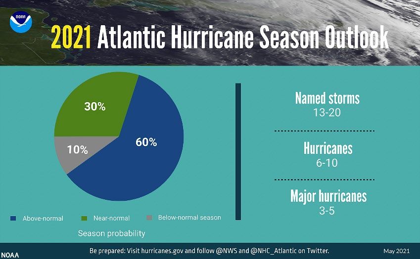
NOAA ta ferwagt ku e temporada di orkan akí lo ta riba promedio den término di aktividat. Esaki ta nifiká mas òf
ménos 13-20 tormenta, di kua 6-10 lo krese bira orkan i di esakinan 3-5 lo bira un orkan grandi (kategoria 3, 4 òf
5). Den un temporada promedio di orkan ta surgi 14 tormenta ku ta haña nòmber, di kua 7 lo krese i bira un
orkan, di nan 3 ta orkannan grandi (kategoria 3,4 5). Wak pa e espektativa kompletu di e temporada:
https://www.noaa.gov/media-release/noaa-predicts-another-active-atlantic-hurricane-season
http://www.cpc.ncep.noaa.gov/products/outlooks/hurricane.shtml
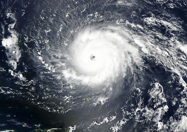
Probabilidat temporada di orkan i kantidat di tormentanan. (NOAA)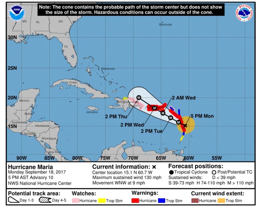
Dunamentu di nòmber na orkan- i tormentanan tropikal pa 2021 ta lo siguiente:

Nòmbernan pa e temporada di orkan 2021. (NOAA)

E sistema di atvertensia
E sistema di atvertensia ku KNMI ta usa pa orkan- i tormentanan tropikal konosé 5 fase.

Fase                               Definishon:

                                   No tin menasa.

Informashon                        Un tormenta tropikal òf orkan ta forma un posibel menasa den e
--- Sea alerta ---                 siguiente 48 te 72 oranan.

Watch (Alerta)                    Tin posibilidat pa kondishonnan di tormenta tropikal òf bientunan di
--- Prepará bo mes ---            orkan den e próksimo 48 oranan.

Warning (Atvertensia)              Ta spera bientunan di tormenta tropikal òf orkan den e próksimo 36
--- Protehá bo mes ---             oranan.

Strike (Impakto)
                                   Ta spera bientunan di tormenta tropikal òf orkan den 6 te 9 ora.
--- Buska lugá di skonde ---

Advisory (Aviso)                   Ta spera yobida pisá i/òf laman brutu, pero sin bientunan di tormenta
--- Sea kouteloso ---              tropikal òf orkan.

Liña di guia: probabel ta ≥ 10% posibilidat, espektativa ta ≥ 50% posibilidat.

Durante e fase di informashon KNMI ta emití un ‘Tropical Cyclone Bulletin’ 2 bia pa dia. Durante e fasenan di
alerta i atvertensia (di impakto) esei ta 4 bia pa dia. Ta inisiá e fasenan di alerta i atvertensia den kooperashon ku
National Hurricane Center (NHC). Un Tropical Cyclone Bulletin ta deskribí e atvertensianan emití, e Key Messages
(informashon mas importante), den kua ta deskribí e espektativa pa loke ta trata bientu, presipitashon i
kondishonnan di laman mas amplio.

Wèpsaitnan importante
National Hurricane Center: http://www.nhc.noaa.gov
Espektativa- i atvertensianan di KNMI: https://www.knmidc.org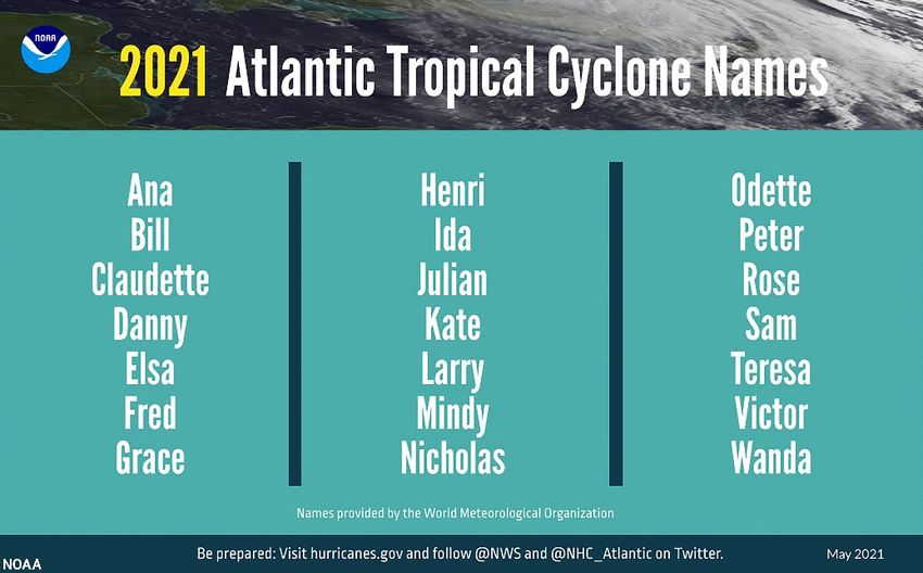
Ehèmpel: Tropical Cyclone Bulletin

TROPICAL CYCLONE BULLETIN NO. 10

WARNING MESSAGE NO. 5
Date: Monday September 18, 2017 Time: 16:30 local time

Key Messages:

- Hurricane watch in effect for dangerous hurricane Maria

- Maria is expected to pass 70 miles (112 km) south of St. Eustatius on Tuesday September 19, 16:00

- Tropical storm winds are expected from Tuesday September 19, 12:00 until Wednesday September
  20, 06:00

- 20-30% risk Hurricane force winds (CAT-1, gusts 85 mph/140 km/h) from Tuesday September 19,
  18:00 until Wednesday September 20, 00:00

- Dangerous 25 ft high waves expected from Tuesday 06:00 till Wednesday 18:00, especially during
  the nearest approach on Tuesday 16:00

- Accumulated rainfall 4-6 inch, possibly up to 8 inch, forecasted with risk of life-threatening flash
  floods and mud slides

Effect on local conditions

Winds:
Tuesday morning easterly winds will increase to tropical storm conditions (maximum gusts 60 mph – 100 km/h)
and may continue till the early night to Wednesday. In this period there is a small risk (20-30%) for hurricane
wind conditions (CAT-1), with gusts up to 85 mph - 140 km/h from Tuesday afternoon. From Wednesday morning
wind speeds are expected to decrease to normal conditions. Wind will turn from East to South during Wednesday
afternoon and evening.

Seas:
A dangerous storm surge accompanied by large and destructive waves will raise water levels by as much as 6 to 9
ft above normal tide levels near where the center of Maria moves across the Leeward Islands.

Rainfall:
Maria is expected to produce total rain accumulations of 4 to 6 inches with isolated maximum amounts of 8
inches. Rainfall could cause life-threatening flash floods and mudslides.

Local authorities and residents of Saba and St. Eustatius are advised to continue monitoring the
further progress of this weather system and to take all necessary measures to safeguard life and
property.

Center's latest and forecast positions:

SABA:
Till Sat Sep 23 14:00 AST, the nearest position is estimated at:

Mon Sep 18 17:00 AST 15.1N 60.7W Category 4 Hurricane 390 km (243 mi) SE of Saba
Tue Sep 19 02:00 AST 15.7N 61.9W Category 4 Hurricane 258 km (160 mi) SE of Saba
Tue Sep 19 14:00 AST 16.5N 63.3W Category 4 Hurricane 126 km (78 mi) S of Saba
Wed Sep 20 02:00 AST 17.3N 64.7W Category 4 Hurricane 160 km (99 mi) WSW of Saba
Wed Sep 20 14:00 AST 18.2N 66.2W Category 4 Hurricane 320 km (199 mi) W of Saba

ST. EUSTATIUS:
Till Sat Sep 23 14:00 AST, the nearest position is estimated at:
Mon Sep 18 17:00 AST 15.1N 60.7W Category 4 Hurricane 360 km (224 mi) SE of St. Eustatius
Tue Sep 19 02:00 AST 15.7N 61.9W Category 4 Hurricane 230 km (143 mi) SSE of St. Eustatius
Tue Sep 19 14:00 AST 16.5N 63.3W Category 4 Hurricane 115 km (72 mi) SSW of St. Eustatius
Wed Sep 20 02:00 AST 17.3N 64.7W Category 4 Hurricane 184 km (114 mi) W of St. Eustatius
Wed Sep 20 14:00 AST 18.2N 66.2W Category 4 Hurricane 350 km (218 mi) WNW of St. Eustatius

Definitions:

HURRICANE WATCH: A warning for hurricane conditions, including sustained winds within the range ≥118 km/h
(≥ 74 mph) (≥64 knots) are possible in specified areas in 48 hours or less.

Next bulletin:

Monday September 18, 2017, 22:30 local time
You can also read