The Imperial Cathedral in Königslutter (Germany) as an Immersive Experience in Virtual Reality with Integrated 360 Panoramic Photography - MDPI
←
→
Page content transcription
If your browser does not render page correctly, please read the page content below
applied
           sciences
Article
The Imperial Cathedral in Königslutter (Germany) as
an Immersive Experience in Virtual Reality with
Integrated 360◦ Panoramic Photography
Alexander P. Walmsley and Thomas P. Kersten *
 HafenCity University Hamburg, Photogrammetry & Laser Scanning lab, Überseeallee 16, 20457 Hamburg,
 Germany; Alexander.Walmsley@hcu-hamburg.de
 * Correspondence: Thomas.Kersten@hcu-hamburg.de

 Received: 6 January 2020; Accepted: 7 February 2020; Published: 23 February 2020

 Abstract: As virtual reality (VR) and the corresponding 3D documentation and modelling technologies
 evolve into increasingly powerful and established tools for numerous applications in architecture,
 monument preservation, conservation/restoration and the presentation of cultural heritage, new
 methods for creating information-rich interactive 3D environments are increasingly in demand.
 In this article, we describe the development of an immersive virtual reality application for the
 Imperial Cathedral in Königslutter, in which 360◦ panoramic photographs were integrated within the
 virtual environment as a novel and complementary form of visualization. The Imperial Cathedral
 (Kaiserdom) of Königslutter is one of the most important examples of Romanesque architecture north
 of the Alps. The Cathedral had previously been subjected to laser-scanning and recording with
 360◦ panoramic photography by the Photogrammetry & Laser Scanning lab of HafenCity University
 Hamburg in 2010. With the recent rapid development of consumer VR technology, it was subsequently
 decided to investigate how these two data sources could be combined within an immersive VR
 application for tourism and for architectural heritage preservation. A specialised technical workflow
 was developed to build the virtual environment in Unreal Engine 4 (UE4) and integrate the panorama
 photographs so as to ensure the seamless integration of these two datasets. A simple mechanic was
 developed using the native UE4 node-based programming language to switch between these two
 modes of visualisation.

 Keywords: 3D modelling; 3D representation; game engine; laser scanning; panoramic photography;
 virtual reality

1. Introduction
      Virtual reality has recently become a much broader field, finding applications in medicine,
architecture, military training, and cultural heritage, among other fields. With this growth has come
some discrepancy in the definition of the medium: while in some fields VR is used to refer to 360◦
immersive panoramas and videos, in other fields it refers to fully-realised interactive CGI environments.
These two “kinds” of VR have traditionally been approached very differently, owing to highly diverging
workflows and the different data sources required. However, there are currently no effective ways of
bringing together these two kinds of data (each of which have their own complementary advantages
in visualisation) into a single VR application. This is particularly important for applications in cultural
heritage, where documentation often takes the form of multiple different kinds of complementary data
(e.g., written, photographic, 3D, video and field recordings, among other forms).
      Virtual reality is defined by Merriam Webster as “an artificial environment which is experienced
through sensory stimuli (such as sights and sounds) provided by a computer and in which one’s

Appl. Sci. 2020, 10, 1517; doi:10.3390/app10041517                              www.mdpi.com/journal/applsci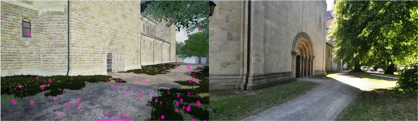
Appl. Sci. 2020, 10, 1517                                                                             2 of 11

actions partially determine what happens in the environment” [1]. This very broad definition allows
for most modern applications of VR to be taken into account. Additional definitions may be found in
literature by Dörner et al. [2], Freina and Ott [3], and Portman et al. [4].
      In the following we present the development workflow for a room-scale virtual reality experience
of a cultural heritage monument which integrates a high-resolution CGI environment with 360◦
panoramic photography, allowing the user to “toggle” between the virtual and the real environments
from within the VR headset. This implementation has the advantage of exploiting the potential for the
interactivity of a real-time game engine environment with the high-fidelity of high dynamic range
image (HDRI) panoramic photography.

2. Related Work
     While much credit for the generalization of VR technology and its increasing accessibility is due
to the video game industry, which has invested heavily in pushing the industry forward [5], VR is now
being employed in a wide range of disciplines. To date, VR has been successfully used for, among
other applications, virtual surgery, virtual therapy, and flight and vehicle simulations. In the field of
cultural heritage, VR has been instrumental in the development of the field of virtual heritage [6–8]. At
the HafenCity University Hamburg, several VR projects concerning this subject have already been
realized. The town museum in Bad Segeberg, housed in a 17th-century townhouse, was digitally
constructed for a VR experience using the HTC Vive Pro [9]. Three historical cities (as well as their
surrounding environments) have been developed as VR experiences: Duisburg in 1566 [10], Segeberg
in 1600 [11], and Stade in 1620 [12]. In addition, two religious and cultural monuments are also
available as VR experiences: the Selimiye Mosque in Edirne, Turkey [13], and a wooden model of
Solomon’s Temple [14].
     The amount of work specifically regarding the real-time VR visualization of cultural heritage
monuments is currently limited but growing. Recent museum exhibits using real-time VR to visualize
cultural heritage include Batavia 1627 at the Westfries Museum in Hoorn, Netherlands [15], and Viking
VR, developed to accompany an exhibit at the British Museum [16]. A number of recent research
projects also focus on the use of VR for cultural heritage visualization [17–20], as well as on aspects
beyond visualisation, including recreating the physical environmental stimuli [21]. The current paper
contributes to this growing discussion by seeking to integrate 360◦ panorama photographs within an
immersive real-time visualization of a cultural heritage monument. At this stage, only very limited
work regarding panoramic photography integration in real-time VR is known to the authors [22].

3. The Imperial Cathedral (Kaiserdom) in Königslutter, Germany
     The town of Königslutter, some 20 km east of Braunschweig (Lower Saxony, Germany),
is dominated by the Imperial Cathedral, known in German as the Kaiserdom (Figure 1). One of the
most impressive examples of Romanesque architecture north of the alps, the cathedral’s construction
was begun under the direction of Kaiser Lothar III, German emperor from 1133 onwards [23,24]. The
church was built in the form of a three-aisled cross-shaped column basilica. The cathedral is notable
particularly for its repeated architectural references to northern Italian architectural styles of the time,
indicating that it might be the work of an Italian architect or indeed someone who was well-travelled
in those regions. Among the most important features of the cathedral is an ornamental hunting frieze,
which hugs the external wall of the main aisle (see Figure 1 centre). Between 2002 and 2006, restoration
was carried out on the exterior of the cathedral, followed by the interior between 2006 and 2010. The
cathedral measures 75 m in length, 42 m in width, and 56 m in height.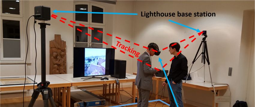
Appl. Sci. 2020, 10, 1517 3 of 11
Appl. Sci. 2020, 10, x FOR PEER REVIEW 3 of 11
Figure1.
Figure 1. Panoramic
Panoramicview
viewofofthe
theImperial
ImperialCathedral in Königslutter,
Cathedral Germany
in Königslutter, Germany(top),(top),
the hunting frieze
the hunting
frieze on the external wall of the main apsis of the cathedral with story-telling figures (centre), and aa
on the external wall of the main apsis of the cathedral with story-telling figures (centre), and
panoramicview
panoramic viewof
ofthe
theinterior
interiorofofthe
thecathedral
cathedral(bottom).
(bottom).
4.4. Methodology
Methodology
4.1.
4.1. Project
Project Workflow
Workflow
The
Theoverall
overallworkflow
workflowfor forthe
theproduction
productionof ofthe
theVR
VRexperience
experienceof ofthe
the Kaiserdom
Kaiserdomisis schematically
schematically
represented
represented in in Figure
Figure 2.2. Special
Special focus
focus was
was given
given to
to achieving
achieving aa realistic
realistic 1:1
1:1 representation
representation of of the
the
cathedral, including the integration of panoramic photos in the VR experience (see
cathedral, including the integration of panoramic photos in the VR experience (see Section 4.6). The Section 4.6). The
project
projectwas
wasdivided
divided intointo
fivefive
major phases
major of development
phases (Figure (Figure
of development 2): (1a) data acquisition
2): (1a) by terrestrial
data acquisition by
laser scanning with one Riegl VZ-400 scanner (outside) and two Zoller + Fröhlich
terrestrial laser scanning with one Riegl VZ-400 scanner (outside) and two Zoller + Fröhlich IMAGER IMAGER 5006
scanners (inside),(inside),
5006 scanners (1b) registration and geo-referencing
(1b) registration of scans usingofRiScan
and geo-referencing scansPro and LaserControl,
using RiScan Pro (1c) and
segmentation
LaserControl,of(1c)point clouds into object
segmentation tiles, clouds
of point (2a) 3D into
solid object
modelling
tiles,with
(2a)AutoCAD
3D solidusing segmented
modelling with
point clouds,using
AutoCAD (2b) generation
segmentedofpointpanoramic
clouds,images
(2b) using PTGui,of(3)panoramic
generation texture mapping
imagesofusing
polygon models
PTGui, (3)
using Autodesk Maya and Substance Painter, (4a) placement of meshes and
texture mapping of polygon models using Autodesk Maya and Substance Painter, (4a) placement building the scene within of
the UE4 game
meshes engine, the
and building (4b)scene
integration
within ofthemotion
UE4 gamecontrol and interactions
engine, in UE4,
(4b) integration (4c) integration
of motion control andof
360 ◦ panoramic imagery, and (5) immersive and interactive visualisation of the cathedral in the VR
interactions in UE4, (4c) integration of 360° panoramic imagery, and (5) immersive and interactive
system HTC Vive
visualisation of thePro using Steam
cathedral in theVRVR2.0 as an HTC
system interface
Vivebetween
Pro using theSteam
game VR engine and
2.0 as anthe Head
interface
Mounted Display (HMD).
between the game engine and the Head Mounted Display (HMD).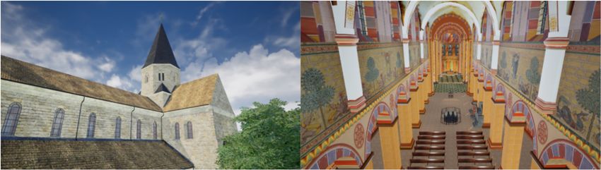
Appl. Sci. 2020, 10, 1517 4 of 11
Appl.
Appl.Sci.
Sci.2020,
2020,10,
10,xxFOR
FORPEER
PEERREVIEW
REVIEW 44ofof11
11
Figure
Figure2.
Figure 2.Workflow
2. Workflowfor
Workflow forthe
for thedevelopment
the developmentofofthe
development thevirtual
virtualreality
reality(VR)
(VR)experience.
experience.
4.2. Data
4.2. Data Acquisition
4.2. DataAcquisition
Acquisition
The
The data acquisition was was already described
described in 2012
2012 in Kersten
Kersten and Lindstaedt
Lindstaedt [25] and and is
The data
data acquisition
acquisition was alreadyalready described in in 2012 inin Kersten and and Lindstaedt [25] [25] and isis
summarised in
summarised in the following.
following. The laserlaser scan data
data for the
the Kaiserdom was was acquired at at 55 stations
stations inside
summarised inthe the following.The The laserscan
scan dataforfor theKaiserdom
Kaiserdom wasacquired
acquired at55 55 stationsinside
inside
the
the cathedral
cathedral by
by two
two Zoller
Zoller +
+ Froehlich
Froehlich IMAGER
IMAGER 5006
5006 (www.zf-laser.com)
(www.zf-laser.com) terrestrial
terrestrial laser
laser scanners,
scanners,
the cathedral by two Zoller + Froehlich IMAGER 5006 (www.zf-laser.com) terrestrial laser scanners,
and at
and 8 stations outside the cathedral by one Riegl VZ-400 (www.riegl.com) on 5on January and 23 June
andatat88stations
stationsoutside
outsidethe thecathedral
cathedralby byone
oneRiegl
RieglVZ-400
VZ-400(www.riegl.com)
(www.riegl.com) on55January Januaryand and23 23
2010
June (Figure
2010 3).
(Figure In total,
3). In the scanning
total, the took
scanning 15 h.
took The
15 scanning
h. The resolution
scanning was set
resolution to
was high
set (6
to mm
high @(610mmm)
June 2010 (Figure 3). In total, the scanning took 15 h. The scanning resolution was set to high (6 mm
for10the
@ IMAGER 5006 and to 5 and mm at 5object space forspace
the RiegltheVZ-400. The precisionprecision
of the geodetic
@ 10m) m)for
forthe
theIMAGER
IMAGER5006 5006 andto to 5mm
mmatatobject
object spacefor
for theRiegl
RieglVZ-400.
VZ-400.The The precisionof ofthe
the
network stations
geodetic network was 2.5 mm,
stations was while
2.5 the precision
mm, while ofprecision
the the controlof points
the for laser
control scanning
points for was scanning
laser 5 mm. In
geodetic network stations was 2.5 mm, while the precision of the control points for laser scanning
order5 to
was later colourise the point cloud, aspoint
well as for the building of the virtual 360◦ panoramic
tour, the
was 5mm.mm.In Inorder
orderto tolater
latercolourise
colourisethethe pointcloud,
cloud,asaswell
wellas asfor
forthe
thebuilding
buildingof of thevirtual
virtualtour,
tour,
photos
360° were taken
panoramic at each
photos wereIMAGER
taken at5006
each scan station5006
IMAGER andscan
at a few supplementary
station and at a few stations using a
supplementary
360° panoramic photos were taken at each IMAGER 5006 scan station and at a few supplementary
Nikon DSLR
stations camera (see Section 4.4).(see Section 3.4).
stationsusing
usingaaNikon
NikonDSLRDSLRcamera
camera (see Section 3.4).
Figure
Figure3.3.Geodetic
Geodetic3D3Dnetwork
network(blue
(blueand
andgreen
greenlines)
lines)and
andposition
positionofofthe
thescan
scanstations
stations(IMAGER
(IMAGER50065006
Figure 3. Geodetic 3D network (blue and green lines) and position of the scan stations (IMAGER 5006 =
==yellow triangles, Riegl VZ-400 = red dots) at the cathedral (left), Riegl VZ-400 point cloud
yellow triangles, Riegl VZ-400 = red dots) at the cathedral (left), Riegl VZ-400 point cloud of (top of (top
yellow triangles, Riegl VZ-400 = red dots) at the cathedral (left), Riegl VZ-400 point cloud of (top right)
right) and 2D 2Dpresentation ofofan
anIMAGER 5006 scan
scan(bottom right).
and 2Dand
right) presentation
presentation of an IMAGER IMAGER 5006
5006 scan (bottom (bottom
right). right).
4.3.
4.3.3D
4.3. 3DModelling
3D Modelling
Modelling
The
The 3D
The 3D modelling
3D modelling was
modelling was also
was also described
also described in
described in 2012
in 2012 in
2012 in Kersten
in Kersten and
Kersten and Lindstaedt
and Lindstaedt [25]
Lindstaedt [25] and
[25] and is
and isis briefly
briefly
briefly
summarised
summarisedin
summarised in the
inthe following.
thefollowing.
following. The
TheThe generated
generated
generated point
point
point cloud,
cloud,
cloud, being
tootoo
being
being toolarge
largelarge to
toimport
import
to import directly
into ainto
directly
directly into
CAD aa
CAD program, was first segmented and then transferred to AutoCAD using the plugin
CAD program, was first segmented and then transferred to AutoCAD using the plugin PointCloud. PointCloud.
Once
Onceimported,
imported,the
thecathedral
cathedralwas
wasblocked
blockedout
outmanually
manuallywith withaa3D
3Dmesh
meshby byextruding
extrudingpolylines
polylinesalong
along
the surfaces and edges of the point cloud structure. This method has the advantage of not
the surfaces and edges of the point cloud structure. This method has the advantage of not generating generating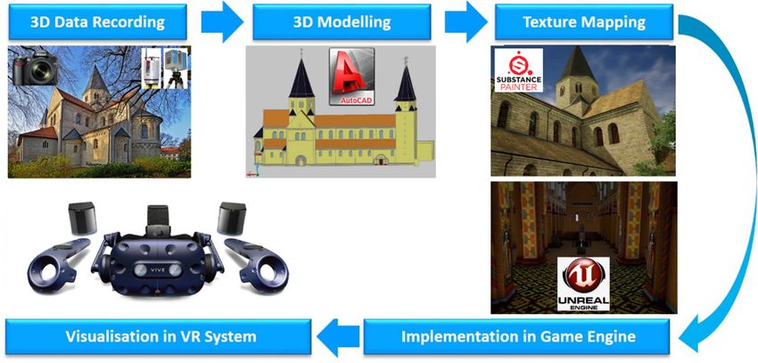
Appl. Sci. 2020, 10, x FOR PEER REVIEW                                                                             5 of 11
Appl. Sci. 2020, 10, 1517                                                                                           5 of 11
too large a file, while retaining visual control of the built model using a superimposed point cloud.
Figure 4 shows the final constructed 3D CAD model of the entire cathedral in four different
program, was first segmented and then transferred to AutoCAD using the plugin PointCloud. Once
perspective views.
imported, the cathedral was blocked out manually with a 3D mesh by extruding polylines along the
      For some smaller details on the cathedral, the automated meshing functions in Geomagic were
surfaces    and10,
Appl. Sci. 2020, edges
                    x FORofPEER
                            the point cloud structure. This method has the advantage of not generating  5 oftoo
used to quickly       generate REVIEW
                                a mesh directly from the point cloud (Figure 5). This works by means      of11a
large a file, while retaining visual control of the built model using a superimposed point cloud. Figure 4
simple triangulation algorithm, which works better for more complex and irregular shapes and
too large
shows    theafinal
               file, constructed
                     while retaining  visualmodel
                                  3D CAD     control of the
                                                  of the    built
                                                         entire   model using
                                                                cathedral       a superimposed
                                                                          in four                point cloud.
                                                                                  different perspective views.
surfaces.
Figure 4 shows the final constructed 3D CAD model of the entire cathedral in four different
perspective views.
      For some smaller details on the cathedral, the automated meshing functions in Geomagic were
used to quickly generate a mesh directly from the point cloud (Figure 5). This works by means of a
simple triangulation algorithm, which works better for more complex and irregular shapes and
surfaces.

     Figure 4.
     Figure  4. Constructed
                Constructed 3D
                            3D model
                               model of
                                     of the
                                         theimperial
                                             imperial cathedral
                                                      cathedral in
                                                                 inKönigslutter,
                                                                   Königslutter, Germany—View of the
                                                                                 Germany—View of the four
                                                                                                     four
     fronts in
     fronts in AutoCAD.
               AutoCAD.

     For some smaller details on the cathedral, the automated meshing functions in Geomagic were
used to quickly generate a mesh directly from the point cloud (Figure 5). This works by means
of a simple triangulation algorithm, which works better for more complex and irregular shapes
     Figure 4. Constructed 3D model of the imperial cathedral in Königslutter, Germany—View of the four
and surfaces.
     fronts in AutoCAD.

     Figure 5. Generation of small complex objects of the cathedral using the meshing function in
     Geomagic for the segmented point clouds.

4.4. Panoramic Photography
      In order to subsequently colourise the point cloud, as well as to generate a virtual online tour of
the cathedral,     aGeneration
                      series of 360°
      Figure 5.5. Generation          panoramic     photos    werethetaken  at eachusing
                                                                                      IMAGER    5006 scan stationinusing
      Figure                   ofof  small
                                  small      complex
                                         complex       objects
                                                  objects of theofcathedral
                                                                        cathedral
                                                                            using the      the meshing
                                                                                       meshing function infunction
                                                                                                            Geomagic
a Nikon    DSLR
      Geomagic
      for
                     camera   with  a
                    for the segmented
          the segmented
                                      nodal   point adapter.
                                         point clouds.
                             point clouds.
                                                                Supplementary       panoramic   photos were also taken
at 10 additional locations outside the cathedral, as well as 19 further points within the cathedral.
4.4.
These
4.4. Panoramic
        were taken
     Panoramic      Photography
                         without any laser-scanning targets or extraneous objects present in the shot. The
                    Photography
acquisition
      In      and
          order to    processing
                  to subsequently
                      subsequently  of the  panoramic
                                        colourise        photography
                                                   thepoint
                                                        point             was
                                                                cloud,asaswell
                                                                            wellalso  described  ina2012   in Kersten   and
      In order                         colourise  the         cloud,            asastoto generate
                                                                                       generate      virtual
                                                                                                a virtual      online
                                                                                                            online     tour
                                                                                                                    tour of
Lindstaedt
of            [25]. For     betterofunderstanding
                                          ◦ panoramic of photos
                                                          the whole     workflow,     the processing  of thescan
                                                                                                               panoramic
thethe  cathedral,
     cathedral,         a series
                   a series  of 360°360
                                      panoramic     photos    werewere
                                                                     takentaken   at IMAGER
                                                                            at each   each IMAGER     5006
                                                                                                5006 scan    stationstation
                                                                                                                     using
photography is briefly summarised in the following. Each set of photographs consists of 16 images—
a Nikon DSLR camera with a nodal point adapter. Supplementary panoramic photos were also taken
at 10 additional locations outside the cathedral, as well as 19 further points within the cathedral.
These were taken without any laser-scanning targets or extraneous objects present in the shot. The
acquisition and processing of the panoramic photography was also described in 2012 in Kersten and
Lindstaedt [25]. For better understanding of the whole workflow, the processing of the panoramic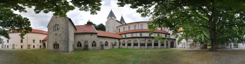
Appl. Sci. 2020, 10, 1517 6 of 11
using a Nikon DSLR camera with a nodal point adapter. Supplementary panoramic photos were
also taken at 10 additional locations outside the cathedral, as well as 19 further points within the
cathedral. These were taken without any laser-scanning targets or extraneous objects present in the
shot. The acquisition and processing of the panoramic photography was also described in 2012 in
Kersten and Lindstaedt [25]. For better understanding of the whole workflow, the processing of the
Appl. Sci. 2020, 10, x FOR PEER REVIEW 6 of 11
panoramic photography is briefly summarised in the following. Each set of photographs consists of 16
images—one
one pointingpointing
towardstowards
the sky,the sky,towards
three three towards the ground
the ground and 12and 12 photos
photos for thefor 360◦ circle
thecircle
360° in the
inhorizontal
the horizontal position.
position. The software
The software PTGuiPTGui automatically
automatically generated
generated a spherical
a spherical panorama
panorama with
with 11,700
11,700 × 5850 pixels (ca. 43 MB) for each camera station. These panorama images
× 5850 pixels (ca. 43 MB) for each camera station. These panorama images were converted into a setwere converted into a
set of six cube images (in total ca. 5 MB). The panorama viewing software KRpano
of six cube images (in total ca. 5 MB). The panorama viewing software KRpano (https://krpano.com) (https://krpano.com)
was
wasinitially
initiallyused
usedtotogenerate
generatean aninteractive
interactivevirtual
virtualtour
tourfor
forweb
webbrowsers
browsers(Figure
(Figure6).6).The
Thetour
tourcan
canbebe
viewed at https://www.koenigslutter-kaiserdom.de/virtuelleTour/tour.html (must
viewed at https://www.koenigslutter-kaiserdom.de/virtuelleTour/tour.html (must have Adobe Flash have Adobe Flash
9/10
9/10enabled).
enabled). In In
thisthis
browser-based
browser-based tour,tour,
all spherical panoramas
all spherical are linked
panoramas are tolinked
each other via hotspots
to each other via
orhotspots
via the overview map (bottom-right corner). This provides a quick and convenient
or via the overview map (bottom-right corner). This provides a quick and convenient way way of navigating
through the panoramas,
of navigating through the simply by clicking
panoramas, on the
simply by relevant
clicking onmap
theicon.
relevant map icon.
Figure6.6. Interactive
Figure Interactive virtual
virtual tour
tour through
through the
theimperial
imperialcathedral
cathedralusing
usingfull
fullspherical
sphericalpanorama
panorama
photographyon
photography onseveral
severalstations
stationsinside
insideand
andoutside
outsideofofthe
thebuilding,
building,including
includingananoverview
overviewmap
mapofof
stations (bottom-right corner).
stations (bottom-right corner).
4.5.
4.5.Game
GameEngine
EngineUnreal
Unrealand
andVR
VRSystem
SystemHTC
HTCVive
Vive
AAgame
game engine is aissimulation
engine a simulationenvironment
environmentwherewhere
2D or 3D
2D graphics can be manipulated
or 3D graphics through
can be manipulated
code. Developed
through primarily by
code. Developed the videoby
primarily games industry,
the video gamestheyindustry,
provide ideal
they platforms
provide idealfor the creation of
platforms for
VR
theexperiences
creation offorVRother purposes
experiences (e.g.,
for othercultural heritage),
purposes as manyheritage),
(e.g., cultural of the necessary
as many functionalities are
of the necessary
already built in, eliminating
functionalities are already the need
built in, to engineer these
eliminating features
the need independently.
to engineer While there
these features are dozens
independently.
ofWhile there are
appropriate dozens
game of appropriate
engines that could game engines
be used, thatpopular
the most could befor
used,
smallthestudios
most popular for small
and production
studios
teams tendand production
to be the Unityteamsenginetend
(Unityto Technologies,
be the Unity San engine (Unity California,
Francisco, Technologies, USA), SanCryEngine
Francisco,
California,
(Crytek, USA), CryEngine
Frankfurt (Crytek, Frankfurt
am Main, Germany) and Unreal amEngine
Main, Germany)
(Epic Games,andCary,
Unreal Engine
North (Epic Games,
Carolina, USA).
Cary,
For thisNorth Carolina,
project, USA).Engine
the Unreal For this
wasproject,
chosen thefor
Unreal Engine was
its advantage in chosen for itsblueprints
the built-in advantagevisual
in the
built-insystem,
coding blueprints
whichvisual
allows coding
users tosystem,
build inwhich
simple allows users toand
interactions build in simple
animations interactions
without and
any prior
animationsofwithout
knowledge C++, the any prior knowledge
programming of C++,
language on the programming
which the engine islanguage on which the engine is
built [26].
built [26].
The specific hardware required to run VR is a VR headset, two “lighthouse” base stations, two
controllers, and a VR-ready PC. For this project, the HTC Vive Pro was chosen as a headset. The
lighthouses are needed to track the user’s movement in 3D space (Figure 7), while the controllers are
used for mapping interactions in the virtual world. Tracking is achieved with a gyroscope,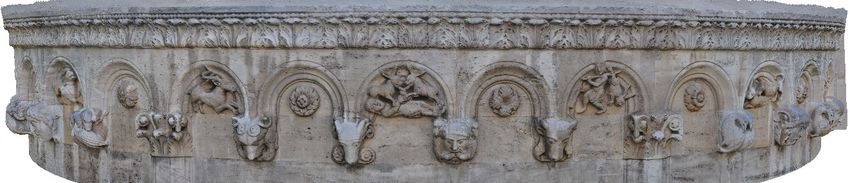
Appl. Sci. 2020, 10, 1517                                                                                7 of 11

     The specific hardware required to run VR is a VR headset, two “lighthouse” base stations, two
controllers, and a VR-ready PC. For this project, the HTC Vive Pro was chosen as a headset. The
lighthouses are needed to track the user’s movement in 3D space (Figure 7), while the controllers
are used for mapping interactions in the virtual world. Tracking is achieved with a gyroscope,
accelerometer, and laser position sensor within the VR headset itself, and can detect movements with
an accuracy of 0.1◦ [27]. Figure 7 shows the setup of the VR system HTC Vive Pro, including the
interaction area (blue) for the user.
 Appl. Sci. 2020, 10, x FOR PEER REVIEW                                                                  7 of 11

       Figure7.7.Components
      Figure      Componentsand schematic
                              and         setup
                                   schematic    of the
                                             setup  of VR
                                                       thesystem HTC Vive
                                                           VR system HTCPro with
                                                                          Vive Prointeraction area (blue).
                                                                                    with interaction   area
       (blue).
4.6. Implementation In Virtual Reality
 4.6. In
      Implementation  in the
         order to bring  Virtual Reality
                             model  into virtual reality, some changes had to be made to the mesh and
textures in order to make them run more efficiently within the game engine. The strict performance
       In order to bring the model into virtual reality, some changes had to be made to the mesh and
criteria of VR mean that every effort needs to be made to optimize the models and ensure that a
 textures in order to make them run more efficiently within the game engine. The strict performance
sufficiently high frame rate (ideally 90 frames per second, though for many applications above 40 is
 criteria of VR mean that every effort needs to be made to optimize the models and ensure that a
sufficient) can be achieved. Much of this part of the workflow was done manually.
 sufficiently high frame rate (ideally 90 frames per second, though for many applications above 40 is
      First, the mesh was split into different parts in order to make the data volume of the files smaller
 sufficient) can be achieved. Much of this part of the workflow was done manually.
and therefore speed up the time taken for each iteration of the texturing process. Because UE4’s built-in
       First, the mesh was split into different parts in order to make the data volume of the files smaller
render engine renders only those meshes and textures that are within the screen-space of the viewer at
 and therefore speed up the time taken for each iteration of the texturing process. Because UE4’s built-
any one time, a logical approach is to separate the interior from the exterior meshes, so as to unload
 in render engine renders only those meshes and textures that are within the screen-space of the
the exterior data when the user is inside the cathedral and vice versa when they are outside. The two
 viewer at any one time, a logical approach is to separate the interior from the exterior meshes, so as
principal parts of the Kaiserdom—the central nave and the cloisters—were also processed separately
 to unload the exterior data when the user is inside the cathedral and vice versa when they are outside.
for the same reason. In a few areas of the model, such as the southern side of the cloister, additional
 The two principal parts of the Kaiserdom—the central nave and the cloisters—were also processed
modelling was done in order to supplement the scan data. A low-poly city model provided by the
 separately for the same reason. In a few areas of the model, such as the southern side of the cloister,
company CPA Software GmbH (Siegburg, Germany) was used as a basis to model low-poly buildings
 additional modelling was done in order to supplement the scan data. A low-poly city model provided
in the area around the Cathedral. As these buildings were not central to the experience, they were
 by the company CPA Software GmbH (Siegburg, Germany) was used as a basis to model low-poly
modelled only in low detail so as not to take up too much rendering space on the GPU. Buildings
 buildings in the area around the Cathedral. As these buildings were not central to the experience,
further away from the Cathedral, which were only visible on the periphery of the virtual environment,
 they were modelled only in low detail so as not to take up too much rendering space on the GPU.
were left in their raw form (simple grey rectangular meshes) to avoid any extraneous modelling work.
 Buildings further away from the Cathedral, which were only visible on the periphery of the virtual
 environment, were left in their raw form (simple grey rectangular meshes) to avoid any extraneous
 modelling work.
       Much of the work in the VR optimization process was dedicated to the production of high-
 quality textures suitable for real-time VR. There is a fundamental trade-off here between the quality
 of the textures needed to appear photorealistic at close range and the data streaming limit of the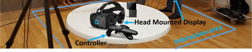
Appl. Sci. 2020, 10, 1517                                                                             8 of 11

      Much of the work in the VR optimization process was dedicated to the production of high-quality
textures suitable for real-time VR. There is a fundamental trade-off here between the quality of the
textures needed to appear photorealistic at close range and the data streaming limit of the engine (which
varies due to hardware and software specifications). As a rule, creating a photorealistic environment
for VR requires high-quality textures in order to boost the experience of immersion. While the Unreal
Engine automatically implements level-of-detail algorithms to reduce the load on the render engine, a
certain amount of manual optimization must be done in addition to achieve performance goals. As
such, texture resolution was varied depending on how far the texture would be from eye-level in the
virtual environment. 4K textures (4096 × 4096 px) were used for high-detail textures that would appear
at eye level, while 2K textures (2048 × 2048 px) were used for textures that appear well above eye
level (for example, the ceiling and roof textures). While many of the textures for this process were
adapted from photos taken at the Kaiserdom, supplementary photo-textures were sourced from a
creative commons licensed CGI texture database (https://texturehaven.com/). For those materials with
more exaggerated relief, such as the building stone and roof tiles, normal maps were also added and
accentuated with a parallax displacement effect built with the native UE4 material creation tools.
      The 3D models with their corresponding textures were exported into UE4 for placement and
real-time visualization (Figure 8A,B). The version of UE4 used in this case was 4.22. Additional
elements such as plant meshes, clouds, fog, environmental lighting, and audio were added to heighten
the sense of photorealism and immersion. In addition, simple interactions were integrated in order to
help the user navigate around the environment. Firstly, a teleportation mechanic was implemented,
allowing the user to jump from location to location. This mechanic makes use of a simple ray-tracer,
pre-built into UE4, that allows the user to point to any location in the virtual world and check that
the location is a valid teleportation point according to a certain set of criteria (these criteria, including
the space available and the slope angle at the location, are calculated by UE4 with its “Navigation
Mesh” feature). If the location is valid as a teleportation point, the user can teleport there with the click
of the trigger button on the controller (Figure 8D). In addition, automatic door-opening animations
were added to several doors in the cathedral, allowing users to move between different parts of
the building as in the real world. A short trailer of the virtual environment can be viewed online
(https://www.youtube.com/watch?v=hmO0JOdlLgw).
      Once the real-time environment was built and VR interactions set up, the 360◦ panoramas could
be integrated. A simple mechanism was implemented in the UE4 engine to make each panorama
viewable. This mechanism was made up of: (1) a visual clue in the virtual world that indicated where
the panorama was located. As an example we used a glowing ring, which stands out well from the rest
of the environment (Figure 8C)—a wide variety of other visual clues may be appropriate; (2) A trigger
box overlapping with the ring, coupled with a function that fires when a certain button is pressed on
the HTC Vive motion controller; (3) A separate, empty map or level in the UE4 editor; and (4) A skybox
in the empty level onto which to project the cube-map panorama. Using this mechanism, the player
can approach a glowing ring, representing a panorama taken on that spot, press a button on the motion
controller, and be transported into the 360◦ panorama. By toggling the button press on the motion
controller, the player can come out of the panorama and be placed back in the virtual world (Figure 9).
Certain variations in this mechanic were tested (e.g., projecting the panoramic photo on the inside of a
sphere in the virtual world, then using a button on the motion controller to alternately showing and
hiding this sphere when the player was in the right area), but the method described above was found
to provide the simplest and most robust way of toggling between the panoramic photos in the scene
while retaining the original perspective of the photographs.
      The finished version of the VR experience was tested with the HTC Vive Pro headset running on a
PC with an 8-Core Intel Xeon CPU (3.10 GHz), an NVIDIA GTX 1070i GPU, and 32.0 GB RAM. With
this setup, the experience achieved an average frame rate of 40–50 frames per second.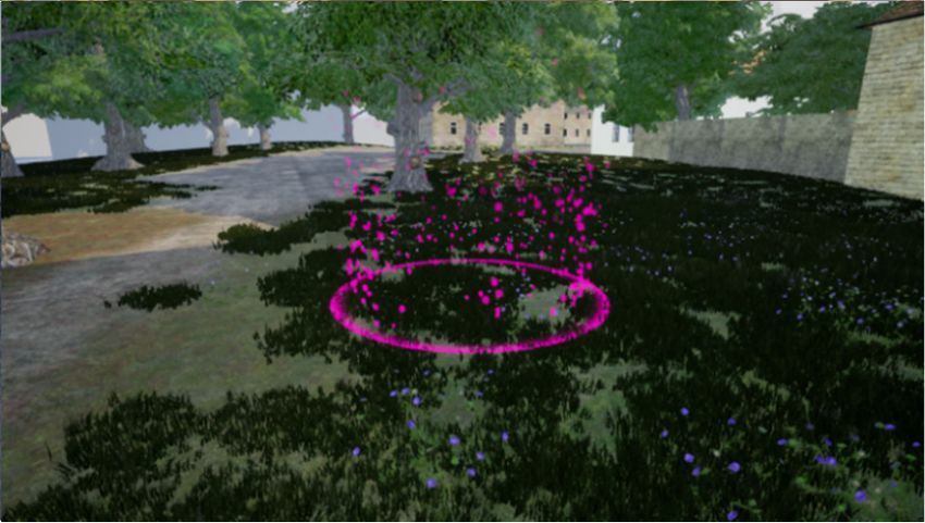
appear well above eye level (for example, the ceiling and roof textures). While many of the textures
for this process were adapted from photos taken at the Kaiserdom, supplementary photo-textures
were sourced from a creative commons licensed CGI texture database (https://texturehaven.com/).
For those materials with more exaggerated relief, such as the building stone and roof tiles, normal
Appl.
maps Sci.were 10, 1517
2020, also added and accentuated with a parallax displacement effect built with the native9 of
UE411
material creation tools.
A B
Appl. Sci. 2020, 10, x FOR PEER REVIEW 9 of 11
C D
(4) A skybox in the empty level onto which to project the cube-map panorama. Using this mechanism,
the player can approach a glowing ring, representing a panorama taken on that spot, press a button
on the motion controller, and be transported into the 360° panorama. By toggling the button press on
the motion controller, the player can come out of the panorama and be placed back in the virtual
world (Figure 9). Certain variations in this mechanic were tested (e.g., projecting the panoramic photo
on the inside of a sphere in the virtual world, then using a button on the motion controller to
alternately showing and hiding this sphere when the player was in the right area), but the method
described above was found to provide the simplest and most robust way of toggling between the
Figure8.photos
panoramic
Figure 8.Two
Twoviewsviews
in the of
thethe
of scene Kaiserdom,
while
Kaiserdom, inside
retaining
inside (A)the(A)
and and outside
original
outside (B). A (B).
thirdAimage
perspective third
of the image
(C) (C)anshows
photographs.
shows example an
example
The of
finished the teleportation
version of mechanic
the VR in action.
experience Image
was (D)
tested shows
with an
theexample
HTC
of the teleportation mechanic in action. Image (D) shows an example of a visual clue placed in the of
Vive a visual
Pro clue
headset placed
running
in
PCthe
on avirtual virtual
with world,
where awhere
an 8-Core
world, Intel a panoramic
Xeon
panoramic CPU (3.10
photo photo
can can bean
beGHz),
viewed. viewed.
NVIDIA GTX 1070i GPU, and 32.0 GB RAM.
With this setup, the experience achieved an average frame rate of 40–50 frames per second.
The 3D models with their corresponding textures were exported into UE4 for placement and
real-time visualization (Figure 8A,B). The version of UE4 used in this case was 4.22. Additional
A
elements such as plant meshes, clouds, fog, environmental lighting, and audio were added to
B
heighten the sense of photorealism and immersion. In addition, simple interactions were integrated
in order to help the user navigate around the environment. Firstly, a teleportation mechanic was
implemented, allowing the user to jump from location to location. This mechanic makes use of a
simple ray-tracer, pre-built into UE4, that allows the user to point to any location in the virtual world
and check that the location is a valid teleportation point according to a certain set of criteria (these
criteria, including the space available and the slope angle at the location, are calculated by UE4 with
its “Navigation Mesh” feature). If the location is valid as a teleportation point, the user can teleport
there with the click of the trigger button on the controller (Figure 8D). In addition, automatic door-
opening animations
Figure
Figure 9.9.View
Viewfrom were
from theadded
the same
to several
sameposition
position inthe
in thedoors inworld,
virtual
virtual
the cathedral,
world, withthe
with
allowing switched
thepanorama
panorama users
switchedto off
move
off(A) between
(A)and
and
different
on parts
(B).
on (B). of the building as in the real world. A short trailer of the virtual environment can be
viewed online (https://www.youtube.com/watch?v=hmO0JOdlLgw).
5.5. Conclusions
Conclusions and Outlook
and
Once the real-time Outlook
environment was built and VR interactions set up, the 360° panoramas could
be integrated.
Thispaper
This A simple
paperpresented
presented mechanism
interestwas
theinterest
the andimplemented
and workflowin
workflow in the UE4
increating
creating aaVR
VRengine to make with
visualization
visualization each panorama
withintegrated
integrated
viewable.
◦
360°panoramic
360 This mechanism
panoramicphotography was
photographyofofthe made up
theKaiserdomof:
Kaiserdom (1) a visual
inin clue
Königslutter.
Königslutter. in the
The virtual
The world
combination
combination that indicated
of these
of these twotwo where
kinds
kinds of
the panorama
of media—real-time
media—real-time was located.
3D3D As an
visualization
visualization example
and and we
HDRI
HDRI used a glowing ring,
panoramicphotography—allows
panoramic which
photography—allowsthe stands out well
theinteractivefrom
interactiveand the
and
rest of the potential
immersive
immersive environment
potentialofof (Figure
thethe 8C)—a
former
former wide variety
to complement
to complement of high-fidelity
the other visual
the high-fidelity clues may be of
and photorealism
and photorealism appropriate; (2) A
of the While
the latter. latter.
trigger box overlapping
While traditionally
traditionally these two these with
two the
“kinds” ring,
“kinds”
of VR coupled
of
have VR have
remainedwith a function
remained
separate, that
separate,
it is fires
it iswhen
important importanta certain button
to investigate
to investigate ways of is
pressed
ways of on
integrating the HTC
integrating
them Vive
themto
in order motion
inbuild controller;
order to build (3)
experiences A separate,
experiences
that are ablethat empty
to mapdifferent
are able
integrate or integrate
to level in the
kinds UE4
different editor;
of data. kinds
Thisandof
is
data. This isimportant
particularly particularly
for important
those fields,for those
such fields, such
as heritage, as heritage,
where where documentation
documentation can take multiplecan take
forms,
multiple
such forms, such as
as photographs, photographs,
objects, 3D data,objects, 3D data,
or written or written
documents. Thedocuments. The futureof
future development development
the virtual
of the virtual
museum, museum,depends
for example, for example, depends
on being onintegrate
able to being able to integrate
different kindsdifferent kinds
of data into of dataspace
a virtual into a
virtual
that canspace that canintuitively
be navigated be navigated intuitively
in virtual in [28].
reality virtual reality [28].
Furtherapplications
Further applicationsof ofthe
theworkflow
workflowdescribed
describedabove
abovecancanalso
alsobebeenvisioned.
envisioned.InInanother
anotherrecent
recent
project,a recreation
project, a recreation of town
of the the town
of Stadeof (Lower
Stade Saxony)
(Lower inSaxony)
the yearin1620
the[12],
yearpanoramic
1620 [12], panoramic
photography
photography is implemented so that users can jump between the real-time visualization of the town
in 1620 and 360° photos from the modern day. This implementation allows users to directly juxtapose
the historic and contemporary city, as an entry point to comparing the historical conditions of the
two periods. In particular, this feature could have extra meaning for users who are already familiar
with the town, by revealing the perhaps unknown history of certain well-known locations. While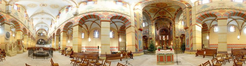
Appl. Sci. 2020, 10, 1517                                                                                  10 of 11

is implemented so that users can jump between the real-time visualization of the town in 1620 and
360◦ photos from the modern day. This implementation allows users to directly juxtapose the historic
and contemporary city, as an entry point to comparing the historical conditions of the two periods. In
particular, this feature could have extra meaning for users who are already familiar with the town,
by revealing the perhaps unknown history of certain well-known locations. While real-time 3D
visualizations on their own may provide a certain degree of immersion, the integration of different
kinds of data in these virtual worlds, such as panoramic photography, can greatly enrich the experience
by inviting the user to compare different kinds of visualizations.
     In addition, by taking real-time visualisations beyond being simply static virtual worlds through
the integration of different kinds of information, VR becomes much more powerful as a tool for
education in museums. Cultural heritage monuments such as the Kaiserdom of Königslutter are
particularly suited to VR exhibition due a substantial existing audience that may be looking for new
ways to extend their visitor experience. By extending real-time visualisations through panoramic
photography and other kinds of information, VR can come closer to realising its potential as a tool for
cultural heritage education.

Author Contributions: T.P.K. and A.P.W. conceived the main research idea about VR; T.P.K. generated the
panorama photography; A.P.W. processed all data and developed the VR application; A.P.W. and T.P.K. wrote
the manuscript and generated the illustrations. All authors have read and agreed to the published version of
the manuscript.
Funding: This research was supported by HafenCity University Hamburg, Lab for Photogrammetry &
Laser Scanning.
Conflicts of Interest: The authors declare no conflicts of interest.

References
1.    “Virtual Reality”. Merriam-Webster.com Dictionary, Merriam-Webster. Available online: https://www.
      merriam-webster.com/dictionary/virtual%20reality (accessed on 4 February 2020).
2.    Dörner, R.; Broll, W.; Grimm, P.; Jung, B. Virtual und Augmented Reality (VR/AR): Grundlagen und Methoden der
      Virtuellen und Augmentierten Realität; Springer: Berlin, Germany, 2014.
3.    Freina, L.; Ott, M. A Literature Review on Immersive Virtual Reality in Education: State of The Art and
      Perspectives; eLearning & Software for Education. Available online: https://ppm.itd.cnr.it/download/eLSE%
      202015%20Freina%20Ott%20Paper.pdf (accessed on 18 December 2019).
4.    Portman, M.E.; Natapov, A.; Fisher-Gewirtzman, D. To go where no man has gone before: Virtual reality in
      architecture, landscape architecture and environmental planning. Comput. Environ. Urban Syst. 2015, 54,
      376–384. [CrossRef]
5.    Fuchs, P. Virtual Reality Headsets—A Theoretical and Pragmatic Approach; CRC Press: London, UK, 2017.
6.    Addison Alonzo, C. Emerging Trends in Virtual Heritage. IEEE MultiMedia 2000, 7, 22–25. [CrossRef]
7.    Stone, R.; Ojika, T. Virtual heritage: What next? IEEE MultiMedia 2000, 7, 73–74. [CrossRef]
8.    Affleck, J.; Thomas, K. Reinterpreting Virtual Heritage. In Proceedings of the CAADRIA 2005, New Delhi,
      India, 28–30 April 2005; Volume 1, pp. 169–178.
9.    Kersten, T.; Tschirschwitz, F.; Deggim, S. Development of a Virtual Museum including a 4D Presentation of
      Building History in Virtual Reality. Int. Arch. Photogramm. Remote Sens. Spat. Inf. Sci. 2017, 42, 361–367.
      [CrossRef]
10.   Tschirschwitz, F.; Richerzhagen, C.; Przybilla, H.-J.; Kersten, T. Duisburg 1566–Transferring a Historic 3D
      City Model from Google Earth into a Virtual Reality Application. PFG J. Photogramm. Remote Sens. Geoinf.
      Sci. 2019, 87, 1–10. [CrossRef]
11.   Deggim, S.; Kersten, T.; Tschirschwitz, F.; Hinrichsen, N. Segeberg 1600–Reconstructing a Historic Town for
      Virtual Reality Visualisation as an Immersive Experience. Int. Arch. Photogramm. Remote Sens. Spat. Inf. Sci.
      2017, 42, 87–94. [CrossRef]
12.   Walmsley, A.; Kersten, T. Low-cost development of an interactive, immersive virtual reality experience of
      the historic city model Stade 1620. Int. Arch. Photogramm. Remote Sens. Spat. Inf. Sci. 2019, 42, 405–411.
      [CrossRef]
Appl. Sci. 2020, 10, 1517 11 of 11
13. Kersten, T.; Büyüksalih, G.; Tschirschwitz, F.; Kan, T.; Deggim, S.; Kaya, Y.; Baskaraca, A.P. The Selimiye
Mosque of Edirne, Turkey—An Immersive and Interactive Virtual Reality Experience using HTC Vive. Int.
Arch. Photogramm. Remote Sens. Spat. Inf. Sci. 2017, 42, 403–409. [CrossRef]
14. Kersten, T.; Tschirschwitz, F.; Lindstaedt, M.; Deggim, S. The historic wooden model of Solomon’s Temple:
3D recording, modelling and immersive virtual reality visualisation. J. Cult. Herit. Manag. Sustain. Dev.
2018, 8, 448–464. [CrossRef]
15. Westfries Museum. Batavia 1627 in Virtual Reality. Hoorn, Netherlands. Available online: https://wfm.nl/
batavia-1627vr (accessed on 17 December 2019).
16. Schofield, G.; Beale, G.; Beale, N.; Fell, M.; Hadley, D.; Hook, J.; Murphy, D.; Richards, J.; Thresh, L. Viking
VR: Designing a Virtual Reality Experience for a Museum. In Proceedings of the Designing Interactive
Systems Conference, ACM DIS Conference on Designing Interactive Systems 2018, Hong Kong, China, 9–13
June 2018; Association for Computing Machinery (ACM): New York, NY, USA, 2018; pp. 805–816.
17. Fassi, F.; Mandelli, A.; Teruggi, S.; Rechichi, F.; Fiorillo, F.; Achille, C. VR for Cultural Heritage. In International
Conference on Augmented Reality, Virtual Reality and Computer Graphics; Springer: Cham, Switzerland, 2016;
pp. 139–157.
18. Dhanda, A.; Reina Ortiz, M.; Weigert, A.; Paladini, A.; Min, A.; Gyi, M.; Su, S.; Fai, S.; Santana Quintero, M.
Recreating cultural heritage environments for VR using photogrammetry. Int. Arch. Photogramm. Remote
Sens. Spat. Inf. Sci. 2019, 42, 305–310. [CrossRef]
19. Skarlatos, D.; Agrafiotis, P.; Balogh, T.; Bruno, F.; Castro, F.; Petriaggi, B.D.; Demesticha, S.; Doulamis, A.;
Drap, P.; Georgopoulos, A.; et al. Project iMARECULTURE: Advanced VR, iMmersive serious games and
augmented REality as tools to raise awareness and access to European underwater CULTURal heritagE. In
Euro-Mediterranean Conference; Springer: Cham, Switzerland, 2016; pp. 805–813.
20. See, Z.S.; Santano, D.; Sansom, M.; Fong, C.H.; Thwaites, H. Tomb of a Sultan: A VR Digital Heritage
Approach. In Proceedings of the 3rd Digital Heritage International Congress (Digital HERITAGE) Held
Jointly with 24th International Conference on Virtual Systems & Multimedia (VSMM 2018), San Francisco,
CA, USA, 26–30 October 2018; pp. 1–4.
21. Manghisi, V.M.; Fiorentino, M.; Gattullo, M.; Boccaccio, A.; Bevilacqua, V.; Cascella, G.L.; Dassisti, M.;
Uva, A.E. Experiencing the sights, smells, sounds, and climate of southern Italy in VR. IEEE Comput.
Graph. Appl. 2018, 37, 19–25.
22. Ramsey, E. Virtual Wolverhampton: Recreating the historic city in virtual reality. ArchNet Int. J. Archit. Res.
2017, 11, 42–57. [CrossRef]
23. Bergmann, N.; Dobler, G.; Funke, N. Kaiserdom Königslutter—Geschichte und Restaurierung; Michael Imhof
Verlag: Petersberg, Germany, 2008.
24. Stiftung Braunschweigischer Kulturbesitz. Königslutter Kaiserdom—The Key Facts. Available
online: https://www.koenigslutter-kaiserdom.de/images/cache/Kaiserdom%20Koenigslutter%20THE%
20KEY%20FACTS.pdf (accessed on 6 January 2020).
25. Kersten, T.; Lindstaedt, M. Virtual Architectural 3D Model of the Imperial Cathedral (Kaiserdom)
of Königslutter, Germany through Terrestrial Laser Scanning. In Proceedings of the EuroMed
2012—International Conference on Cultural Heritage, Limassol, Cyprus, 29 October–3 November 2012;
Lecture Notes in Computer Science (LNCS). Ioannides, M., Fritsch, D., Leissner, J., Davies, R., Remondino, F.,
Caffo, R., Eds.; Springer: Berlin/Heidelberg, Germany, 2012; Volume 7616, pp. 201–210.
26. McCaffrey, M. Unreal Engine VR Cookbook; Addison-Wesley Professional: Boston, MA, USA, 2017.
27. Painter, L. Hands on with HTC Vive Virtual Reality Headset. 2015. Available online: http://www.pcadvisor.
co.uk/feature/gadget/hands-on-with-htc-vive-virtual-reality-headset-experience-2015-3631768/ (accessed
on 18 December 2019).
28. Giangreco, I.; Sauter, L.; Parian, M.A.; Gasser, R.; Heller, S.; Rossetto, L.; Schuldt, H. VIRTUE: A Virtual Reality
Museum Experience. In Proceedings of the 24th International Conference on Intelligent User Interfaces:
Companion IUI’ 19, Los Angeles, CA, USA, 16–20 March 2019; pp. 119–120.
© 2020 by the authors. Licensee MDPI, Basel, Switzerland. This article is an open access
article distributed under the terms and conditions of the Creative Commons Attribution
(CC BY) license (http://creativecommons.org/licenses/by/4.0/).You can also read