Background conditions for an urban greenhouse gas network in the Washington, DC, and Baltimore metropolitan region
←
→
Page content transcription
If your browser does not render page correctly, please read the page content below
Atmos. Chem. Phys., 21, 6257–6273, 2021
https://doi.org/10.5194/acp-21-6257-2021
© Author(s) 2021. This work is distributed under
the Creative Commons Attribution 4.0 License.

Background conditions for an urban greenhouse gas network
in the Washington, DC, and Baltimore metropolitan region
Anna Karion1 , Israel Lopez-Coto1,2 , Sharon M. Gourdji1 , Kimberly Mueller1 , Subhomoy Ghosh1,3 ,
William Callahan4 , Michael Stock4 , Elizabeth DiGangi4 , Steve Prinzivalli4 , and James Whetstone1
1 Special Programs Office, National Institute of Standards and Technology, Gaithersburg, MD 20899, USA
2 School of Marine and Atmospheric Sciences, Stony Brook University, Stony Brook, NY 11794, USA
3 Center for Research Computing, University of Notre Dame, South Bend, IN 46556, USA
4 Earth Networks, Germantown, MD 20876, USA

Correspondence: Anna Karion (anna.karion@nist.gov)

Received: 10 December 2020 – Discussion started: 15 January 2021
Revised: 20 March 2021 – Accepted: 22 March 2021 – Published: 26 April 2021

Abstract. As city governments take steps towards estab-         1   Introduction
lishing emissions reduction targets, the atmospheric research
community is increasingly able to assist in tracking emis-
sions reductions. Researchers have established systems for      In efforts to increase sustainability and address climate
observing atmospheric greenhouse gases in urban areas with      change, governments, private entities, and other stakehold-
the aim of attributing greenhouse gas concentration enhance-    ers are tracking their greenhouse gas (GHG) emissions over
ments (and thus emissions) to the region in question. How-      time. Atmospheric observations have a crucial role to play
ever, to attribute enhancements to a particular region, one     in this effort, as they have the potential to provide a use-
must isolate the component of the observed concentration at-    ful tool for assessing the effectiveness of emissions mitiga-
tributable to fluxes inside the region by removing the back-    tion efforts. Urban atmospheric GHG monitoring networks
ground, which is the component due to fluxes outside. In        have proliferated in the past decade, established by the car-
this study, we demonstrate methods to construct several ver-    bon cycle research community to assess the ability of such
sions of a background for our carbon dioxide and methane        networks to detect trends and anomalies in urban emissions
observing network in the Washington, DC, and Baltimore,         (Mitchell et al., 2018; Sargent et al., 2018; Lauvaux et al.,
MD, metropolitan region. Some of these versions rely on         2020). Emissions estimates from such atmospheric obser-
transport and flux models, while others are based on obser-     vations rely on separating observed concentrations into two
vations upwind of the domain. First, we evaluate the back-      components: the concentration in the air entering the study
grounds in a synthetic data framework, and then we eval-        domain and the enhancements in concentration attributable
uate against real observations from our urban network. We       to emissions within the domain. This enhancement isolation
find that backgrounds based on upwind observations cap-         is necessary for analysis, whether it be for formal statisti-
ture the variability better than model-based backgrounds, al-   cal inverse modeling of surface fluxes or for unbiased trend
though care must be taken to avoid bias from biospheric         detection. In urban areas, background determination is of-
carbon dioxide fluxes near background stations in summer.       ten difficult given the typically smaller study domain and the
Model-based backgrounds also perform well when upwind           temporal and spatial variability of the background conditions
fluxes can be modeled accurately. Our study evaluates differ-   relative to regional or global studies (Mueller et al., 2018;
ent background methods and provides guidance in determin-       Balashov et al., 2020; Xueref-Remy et al., 2018).
ing background methodology that can impact the design of           Previous GHG studies in urban regions have utilized ob-
urban monitoring networks.                                      servations from a variety of platforms, including aircraft,
                                                                ground-based column instruments, satellites, and in situ sta-
                                                                tionary locations (such as rooftops or towers). Different ap-

Published by Copernicus Publications on behalf of the European Geosciences Union.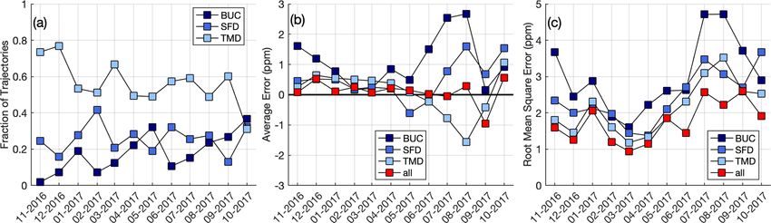
6258                  A. Karion et al.: Background conditions for an urban greenhouse gas network in Washington, DC

proaches have been used to isolate the background from ob-        time series constructed in different ways, including methods
served concentrations from any of these platforms in order        that rely on modeled upwind fluxes, against observations and
to perform analysis on enhancements. Urban analyses based         compare their performance. Section 5 includes discussion of
on ground-based in situ GHG observations often establish          the results, and Sect. 6 gives conclusions and recommenda-
background concentrations using measurements from sta-            tions.
tions outside the urban domain, either upwind (often filter-
ing data for a given wind sector) or in an area far from ur-
ban emissions. Sometimes these are from observations from         2     Methods
a remote or baseline station, such as a mountain top or off-
shore location (Mitchell et al., 2018; Verhulst et al., 2017).    2.1    Definition of domain and background
These background measurements are filtered for clean condi-
                                                                  Here we define the background for a given urban measure-
tions to remove pollution events for example. A lowest per-
                                                                  ment as the mole fraction that would be observed at that
centile method has also been used as background, e.g., the
                                                                  location and time in the absence of any GHG fluxes inside
lowest 5 % of measurements during a certain time period,
                                                                  the domain of interest. Therefore, we separate the CO2 or
or a network-wide minimum value (Shusterman et al., 2016;
                                                                  CH4 mole fraction measured at each station (y) as a com-
Ammoura et al., 2016). In many studies, observations from a
                                                                  bination of a background (yBG ) and an enhancement from
station that is upwind given daily meteorological conditions
                                                                  fluxes within the domain of interest (yenh ):
are used for background (Xueref-Remy et al., 2018; Lau-
vaux et al., 2016; Breon et al., 2015; Balashov et al., 2020),    y = yBG + yenh .                                           (1)
most often using observations from the same time of day as
the urban station. A recent study of carbon dioxide (CO2 ) in     We note that yenh may be positive or negative, depending on
Boston used a more complex back-trajectory-based method           the direction of fluxes in the domain. For our study, this do-
to sample the upwind station (Sargent et al., 2018). The back-    main is an area approximately 140 km by 135 km surround-
ground could also be optimized along with the urban fluxes        ing the cities of Washington, DC, and Baltimore, MD, and
within the inverse analysis (Nickless et al., 2018).              encompassing their larger metropolitan areas (Fig. 1). A net-
   The goal of this study is to construct and evaluate a back-    work of observation stations on existing towers has been es-
ground for the Northeast Corridor Washington DC/Baltimore         tablished by Earth Networks and NIST comprising 11 urban
tower-based urban network described in Karion et al. (2020).      towers, i.e., towers situated inside the domain, and 3 back-
We investigate many of the methods mentioned above, with          ground towers, i.e., towers situated near the edges (TMD,
some exceptions: we do not investigate the baseline/remote        SFD, and BUC in Fig. 1). Locations were determined by net-
station, low-percentile, or optimized background methods.         work design studies (Lopez-Coto et al., 2017; Mueller et al.,
The Washington/Baltimore region is downwind of many               2018). Details on the atmospheric CO2 and CH4 mole frac-
large flux regions (both anthropogenic and biospheric), and       tion measurements from this network are found in Karion
previous work has shown large synoptic variability in the         et al. (2020). In this study we use observations from the six
background for the urban area (Mueller et al., 2018), so the      urban sites in Fig. 1, as we focus on November 2016 through
use of a remote station or a lowest percentile method is not      October 2017, when only these six had been established. In
likely to produce an accurate representation of background        this work, CO2 measurements are given as dry air mole frac-
variability. Optimizing the background in an inversion frame-     tions, with units of µmol mol−1 , or parts per million (ppm);
work along with fluxes could be an option for our domain,         CH4 dry air mole fractions are in units of nmol mol−1 , or
but we do not perform an inverse analysis here. Instead, we       parts per billion (ppb).
present some background options that could be used as initial
guesses, or priors, in a Bayesian framework for optimization      2.2    Transport model
in the future.
   Although the analysis we present is focused on CO2 and         Many of the methods we use for estimating yBG rely on
methane (CH4 ) in the Washington DC/Baltimore urban do-           a transport model simulation of the domain. We use me-
main, we expect many of the overall methods for background        teorological fields from the Weather Research and Fore-
estimation and evaluation explored in this study to be extensi-   cast (WRF) model to drive the Stochastic Time-Inverted La-
ble to other urban or regional networks. In Sect. 2, we outline   grangian Model (STILT; Lin et al., 2003). Following Lopez-
the methods for the study, including how we determine back-       Coto et al. (2020a), WRF is configured with the RRTMG
ground values for the Washington DC/Baltimore network. In         radiation scheme (Mlawer et al., 1997), Thompson micro-
Sect. 3, we perform a synthetic data analysis to evaluate CO2     physics scheme (Thompson et al., 2004, 2008), Noah land
biases in three methods that use upwind observations from         surface model (Chen and Dudhia, 2001), Kain–Fritsch cu-
surface stations near the domain edge. We use the synthetic       mulus scheme (for the 9 km domain only) (Kain, 2004), 1.5-
experiment to determine the best way to use these upwind ob-      order closure scheme MYNN (Nakanishi and Niino, 2004,
servations. In Sect. 4 we evaluate CO2 and CH4 background         2006) with the eddy mass-flux option (Olson et al., 2019)

Atmos. Chem. Phys., 21, 6257–6273, 2021                                              https://doi.org/10.5194/acp-21-6257-2021
A. Karion et al.: Background conditions for an urban greenhouse gas network in Washington, DC 6259
larger of the two domains by that time. The analysis covers
the 1-year time period from November 2016 through October
2017.
2.3 Sampling a global model at the urban domain
boundary
In the next few sub-sections we describe several methods for
estimating the background that we investigate in this work
(Table 1), beginning with methods relying on global model
output.
In the global model method, a 4D field of the GHG mole
fractions from an existing global model is sampled by each
STILT particle as it exits (enters) the urban domain (Fig. 1)
at a given latitude, longitude, altitude, and time. Here, for
CO2 we use publicly available mole fraction output from
two different global CO2 inversion models: CarbonTracker
(CT) version CT2019 (http://carbontracker.noaa.gov, last ac-
Figure 1. Domain of interest for our study (red square), surround-
cess: 6 January 2020; Peters et al., 2007; Jacobson et al.,
ing the metropolitan regions of Washington, DC, and Baltimore,
2020) and Carbon Tracker Europe (CTE (obtained by re-
MD. Gray shading indicates U.S. Census-designated urban areas
(http://www.census.gov, last access: 23 March 2017). Red triangles quest); Peters et al., 2010). These two are referred to as
indicate urban stations used in this study, and blue triangles indicate Global-CT and Global-CTE (Table 1). Both global models
background stations. All map data layers obtained from either Nat- provide vertically resolved, 3-hourly, 1◦ resolution CO2 mole
ural Earth (naturalearthdata.com) or U.S. Government sources and fraction fields. For CH4 , we use the Copernicus Atmosphere
in the public domain. Monitoring Service (CAMS) global inversion 4D fields at
4-hourly, 2◦ × 3◦ resolution (v17rs1, available at https://
apps.ecmwf.int/datasets/data/cams-ghg-inversions/, last ac-
and the land-use classification from the 2011 National Land cess: 26 April 2019; Segers and Houweling, 2018) (Global-
Cover Database (Homer et al., 2015). Three nested domains CAMS). The advantage of sampling a global model as a
are used (9, 3 and 1 km), with the innermost domain covering background is that the mole fraction field varies in space and
the urban area of interest, with 60 vertical levels with mono- time, and this field is generated from fluxes optimized us-
tonically increasing thickness from the surface (34 levels be- ing atmospheric observations. A disadvantage, however, is
low 3 km) and driven by initial and boundary conditions from the global models’ resolution is quite coarse relative to our
the North American Regional Reanalysis (NARR) 3-hourly small (∼ 140 km across) domain and may not provide suf-
data (Mesinger et al., 2006). ficient spatial resolution for the background (i.e., the entire
STILT generates influence functions, or footprints, that re- domain is only slightly larger than one CarbonTracker grid
late the enhancement measured at a given observation loca- cell).
tion to fluxes from an area at the surface. STILT also tracks
mass-less particles backward in time, and here we use the 2.4 Using a nested domain to define a two-component
particles from each observation to determine the location and background
time of exit from the domain (i.e., this is analogous to the
location of entry of each air parcel into the domain before A second method of estimating a background is to use a
eventually reaching the observation point). For this work, we nested domain and separate the background yBG from Eq. (1)
emit 960 particles for each hourly mean observation from into two components (Eq. 2).
both urban and background towers. Particles are released
over the entire hour to simulate the hourly mean and tracked yBG = yBGfar + yBGnear (2)
back in time for 5 d. Footprints are calculated for two nested
domains: an inner domain with a footprint gridded at 0.01◦ The first component, yBGfar , is obtained by sampling a global
(shown in Fig. 1) and an outer domain with a footprint grid- model as described above but at a boundary far from the
ded at 0.1◦ (Fig. 2); the exit points of the particles are de- domain of interest (magenta boundary in Fig. 2). The sec-
termined for both domains. The choice of the two domains ond component, yBGnear , is determined from convolutions of
was made specifically for our region in order to capture large STILT footprints with a flux field in the outer domain. The
emissions sources and other urban areas outside Washington, fluxes within the inner domain of interest are set to zero, so
DC, and Baltimore. The simulation time for STILT of 5 d was that yBGnear does not include any enhancements from the in-
chosen so that most of the particles (over 90 %) had exited the ner domain. It only represents enhancements from fluxes be-
https://doi.org/10.5194/acp-21-6257-2021 Atmos. Chem. Phys., 21, 6257–6273, 20216260 A. Karion et al.: Background conditions for an urban greenhouse gas network in Washington, DC
Figure 2. Maps of nested domains used to calculate the two-component background. The outer domain (magenta) is used to determine the
near-field background (yBGnear ) using footprints from STILT and existing flux inventories. (a) January 2015 mean of fossil-fuel CO2 from
Vulcan 3.0 with FFDAS in the Canada portion of the domain is shown in log scale. (b) January 2015 mean of the EPA CH4 inventory with
EDGAR in the Canada portion of the domain is shown in log scale. A global model is sampled at the edge of the outer domain for the far-field
background (yBGfar ). The red square over Washington, DC, and Baltimore, MD, corresponds to the domain shown in Fig. 1. The white star
indicates the location of the NOAA aircraft site CMA. All map data layers obtained from U.S. Government sources and in the public domain.
tween the outer domain and the inner domain (Fig. 2 shows ically, this method is problematic for CH4 , where existing
examples of these fluxes). inventories have been shown to disagree significantly with
One disadvantage of this two-component background is measurements in the region upwind of our domain, likely due
that, in our case, the fluxes used in the outer domain are not to underestimation of oil and gas emissions (Barkley et al.,
optimized using atmospheric observations; we rely on exist- 2019). We also note that these inventories are for different
ing inventories and biospheric models. In addition, the ex- years than our study. One future goal of our project is to use
isting anthropogenic inventories were developed for a dif- inverse modeling to optimize fluxes in the outer domain to
ferent year than the study (for both CO2 and CH4 ), intro- improve the accuracy of the background for the inner do-
ducing additional uncertainty. However, the spatial resolu- main.
tion of the fluxes and meteorological model is better than for
the global models (9 km for WRF and 0.1◦ for the fluxes vs. 2.5 Using observations upwind of the urban domain,
1◦ or more for the global models) and thus may better cap- three different ways
ture variability in background concentrations. We also can
use different flux fields to estimate a range of background
Observations upwind of the domain of interest have been
options using this method. For CO2 we have used Vulcan
the most commonly used choice for background for urban
3.0 (Gurney et al., 2020b, a) for anthropogenic fluxes in the
studies (Lauvaux et al., 2016; Sargent et al., 2018; Nick-
US and the Fossil Fuel Data Assimilation System (FFDAS)
less et al., 2018). The advantage to using observations over
(Asefi-Najafabady et al., 2014) in Canada. Both products are
model-based estimates is clear: there is no need to depend on
for the year 2015 and are adjusted to match the day of the
a global model or assume upwind fluxes are known. A back-
week in the study year (2016/17) (Fig. 2a). We also use out-
ground station also captures the variability in time that is ex-
put from two biosphere models: a custom Vegetation Pho-
pected of the background but will not capture the variability
tosynthesis and Respiration Model (VPRM) (Gourdji et al.,
in space, a consideration in this area with large spatial vari-
2021) and an ensemble mean of the Carnegie-Ames-Stanford
ability in upwind fluxes. In this study, we determine the up-
Approach (CASA) model run (Zhou et al., 2020) for bio-
wind station as the location that minimizes the difference be-
sphere fluxes (both for the time period of our study). We
tween the mean particle exit angle and the angle to the back-
refer to these two combinations as CT + V3 + VPRM and
ground site. First, each particle from our WRF-STILT model
CT + V3 + CASA (Table 1). For CH4 , we have used the EPA
of an urban tower observation is tracked back to its exit lo-
2012 gridded inventory (Maasakkers et al., 2016) (Fig. 2b)
cation from the domain, and the nearest background station
and EDGAR v5.0 2015 (https://edgar.jrc.ec.europa.eu, last
is determined by comparing the exit angle and the angle be-
access: 11 February 2020; Crippa et al., 2019) (referred to as
tween the background site and the urban station. We choose
CAMS + EPA and CAMS + EDGAR, respectively). We do
between the stations in Thurmont, MD (TMD), Stafford, VA
not expect large biases in the anthropogenic CO2 inventory
(SFD), and Bucktown, MD (BUC). If the nearest station does
fluxes at this regional scale, but the CH4 and biosphere CO2
not have observations for the time that the particle exited, the
fluxes are less well-known and may introduce error. Specif-
next nearest is used. Until May 2017, only one background
Atmos. Chem. Phys., 21, 6257–6273, 2021 https://doi.org/10.5194/acp-21-6257-2021A. Karion et al.: Background conditions for an urban greenhouse gas network in Washington, DC 6261
Table 1. Summary of background methods compared and evaluated for CO2 and CH4 . References for all the models can be found in the
pertinent Methods section.
Abbreviation Type of background yBGfar yBGnear yBG Evaluation
methodb
(S: synthetic,
R: real)
CO2
Global-CTE Global model sampling at CarbonTracker Europe R
inner domain boundary
Global-CT Global model sampling at CarbonTracker CT2019 R
inner domain boundary
CT + V3 + VPRM Nested background CarbonTracker Vulcan yBGfar + yBGnear R
CT2019 3.0a + VPRM
(1◦ × 1◦ ) (0.1◦ × 0.1◦ )
CT + V3 + CASA Nested background CarbonTracker Vulcan yBGfar + yBGnear R
CT2019 3.0a + CASA
(1◦ × 1◦ ) (0.1◦ × 0.1◦ )
Upwind lagged Observations from upwind Sampled at the time of S
site air mass exit
Upwind aft Observations from upwind Mean afternoon S, R
site average from same day
Upwind column Observations from upwind Sampled from a vertical S, R
site column (profile)
CH4
Global-CAMS Global model sampling at CAMS CH4 v17r1s R
inner domain boundary
CAMS + EPA Nested background CAMS CH4 EPA 2012a yBGfar + yBGnear R
v17r1s (2◦ ×3◦ ) (0.1◦ × 0.1◦ )
CAMS + EDGAR Nested background CAMS CH4 EDGAR v5.0 yBGfar + yBGnear R
v17r1s (2◦ ×3◦ ) 2015
(0.1◦ × 0.1◦ )
Upwind lagged Observations from upwind Sampled at the time of R
site air mass entrance
Upwind aft Observations from upwind Mean afternoon R
site average from same day
Upwind column Observations from upwind Sampled from a vertical R
site column
a Models using Vulcan 3.0 as the flux in the near-field background use FFDAS 2015 and models using EPA use EDGAR v4.2 for the small region in Canada within our outer
domain (Fig. 2). b The rightmost column indicates whether this background was evaluated in the synthetic data study (S; Sect. 3) or against actual (real) observations (R; Sect. 4).
site was operational, BUC, meaning that backgrounds con- only one site without filtering for particular wind directions,
structed using any of the upwind-observation-based methods as other studies have done.
always use BUC until May 2017, when TMD was estab- In this section, we describe three ways to use measure-
lished. SFD was established in July 2017, so after that pe- ments from an upwind measurement station and then evalu-
riod all three stations were options. Note that in the synthetic ate them for CO2 in Sect. 3 using a synthetic data study. We
data study, we use all three sites for the entire year as the choose the best method among these to evaluate along with
ideal case scenario and then investigate the effect of using model-based methods for both CO2 and CH4 in the real data
study (Sect. 4).
https://doi.org/10.5194/acp-21-6257-2021 Atmos. Chem. Phys., 21, 6257–6273, 20216262 A. Karion et al.: Background conditions for an urban greenhouse gas network in Washington, DC
2.5.1 Upwind lagged method wind location using an ensemble of particle trajectories from
STILT, as was done to sample the global model (Sect. 2.3).
We investigate using measurements from an upwind station This method has been used previously in regional studies
in a truly Lagrangian fashion, i.e., to sample the upwind ob- to sample an upwind curtain that was constructed using
servations at the time an air parcel enters the domain of in- smoothed long-term measurements (Jeong et al., 2016; Kar-
terest. This is typically not an effective method because at ion et al., 2016). In those studies, the STILT particles were
earlier times of the day, the mixing depth is often shallower used to sample a mole fraction field (curtain) at the edge of
than it is later in the day, and this method does not account for the domain with latitudinal, vertical, and temporal variability.
dilution of concentrations due to a growing planetary bound- Unfortunately, in our case, we do not have enough upwind
ary layer (PBL). The background will be biased high and, measurements to construct a full boundary curtain. Instead,
thus, the enhancement determined at the urban tower would we combine the idea of sampling a background curtain using
be negatively biased. In a synthetic data investigation of how the particles’ exit locations and times with the idea of sam-
to site background stations, Mueller et al. (2018) showed that pling an upwind measurement station, similarly to Sargent
although the upwind measurements sampled in this manner et al. (2018). We construct vertical profile columns of CO2
correlated well with the true background at the urban sites, and CH4 that do not vary laterally but allow the particles to
they were biased high. sample a realistic vertical mole fraction gradient and aver-
age the mole fractions in the column across the particles to
2.5.2 Upwind afternoon method calculate at the background value (yBG ). Below we describe
the method for constructing vertical profile CO2 and CH4
A common method for overcoming the problem of diurnally columns at upwind sites for use with this method.
varying boundary layer depth is to approximate the dilution For every urban observation that we model using STILT,
in concentration by using upwind observations at the same we construct a vertical profile, or column, background to
time as the observations at the urban site, when the PBL is sample with the particle trajectories. Once the background
similar between the two (e.g., Lauvaux et al., 2016). In our station is identified using the particle trajectories as described
case, because we restrict our analysis to afternoon hours at earlier, the modeled boundary layer height associated with
the urban sites, this translates to sampling the upwind tower the exiting particle’s exit location and time is used to con-
in the afternoon as well. This method must be considered struct a vertical profile y(z) as shown in Eqs. (3) and (4) and
carefully, and its effectiveness depends on the specific geog- described below, where y is the mole fraction in the column
raphy and location of the urban and rural measurement sta- and z is the altitude above ground level (a.g.l.). We define two
tions as well as the size of the domain. For example, on a cases: one for afternoon hours (Eqs. 3a and 3b) and one for
summer day, a rural upwind tower at mid-day could be influ- non-afternoon hours (Eqs. 3c through 3e); note that the time
enced by strong local photosynthetic uptake causing a bias of day referred to here is the local time at which the particles
relative to the air measured at the urban tower at the same exit the domain, not the time of the urban observation.
time; even if the same air mass passed the upwind tower, it Afternoon hours:
did so earlier in the day when there was less uptake. An-
other concern is that on days with more complex or shifting y(z) = yobs , z ≤ PBL, (3a)
winds, the upwind tower may not represent air originating in y(z) = yFT , z > PBL. (3b)
the same area as the air mass sampled farther downwind in
the city. In a smaller domain, transit times to the boundaries Non-afternoon hours:
are shorter in general, and this effect may not cause much
error. Otherwise, to alleviate the effect of these near-field y(z) = yobs , z ≤ PBL, (3c)
fluxes when using a background observation at the same time y(z) = A + Be(−z/800 m) , PBL < z ≤ 2000 m, (3d)
as the urban observation, modeled enhancements (estimated y(z) = yFT , z > 2000 m, (3e)
using inventories inside the domain) from sources within the
domain could be subtracted from the upwind concentration where the parameters A and B are constants calculated by
(Lauvaux et al., 2016). However, if near-field fluxes outside imposing two boundary conditions on Eq. (3d):
the model domain influence the upwind towers (as is the
case in our domain, because our background towers are ei- y(z = PBL) = yobs , (4a)
ther very close to the edge or outside the domain entirely), y(z = 2000) = yprevAFT . (4b)
this correction may not entirely eliminate the problem.
If the particle exited during afternoon hours (defined as 5 h
2.5.3 Upwind column method after sunrise and before sundown), then the profile repre-
sents a two-layer troposphere consisting of the background
This method accounts for dilution by free tropospheric air site observation (yobs ) from the ground to the top of the PBL
being entrained into the growing PBL by sampling the up- and the free troposphere value, yFT (discussed below), above
Atmos. Chem. Phys., 21, 6257–6273, 2021 https://doi.org/10.5194/acp-21-6257-2021A. Karion et al.: Background conditions for an urban greenhouse gas network in Washington, DC 6263
the PBL (Eqs. 3a and 3b). If the particle exits during non- with a large influence of local wetlands (Karion et al., 2020),
afternoon hours, the profile is constructed in three layers. The so that the synthetic experiment would not yield necessar-
lowest layer, below the PBL, consists of the observation at ily realistic results without an accurate wetland model. The
the background tower at the exit time, yobs (Eq. 3c). From same-day afternoon sampling of CO2 is also more likely to
the PBL to 2000 m a.g.l., the profile is assumed to be a resid- be a problem due to strong biospheric fluxes in summer in-
ual layer and is modeled as an exponential decay function fluencing observed concentrations at the background station;
beginning with the tower observation (yobs ) at the PBL top whether the column method alleviates this issue was a key
to the concentration measured at that same site the previous question to answer with the synthetic experiment.
day (mid-day afternoon average), yprevAFT (Eq. 3d). Above A set of synthetic CO2 observations y was constructed us-
2000 m a.g.l., the profile is based on the free-tropospheric ing the WRF-STILT footprints from our model for 5 Novem-
value yFT (Eq. 3e). The height of the residual layer (2000 m) ber 2016 through 30 October 2017, for six urban sites (NWB,
and the length scale of the exponential function (800 m) NEB, HAL, JES, NDC, and ARL) and all three background
were determined using the synthetic experiment described sites (BUC, SFD, TMD) for the entire time period; see Fig. 1
in Sect. 3 by testing several values and choosing the best- for locations). Note that in order to evaluate the effectiveness
performing combination (not shown). The choices for both of the method, we simulated all three upwind sites for the en-
of these values introduce error in the column background; tire year even though in reality two of them were established
for example, the height of the residual layer would change later in the year (May 2017 and July 2017 for TMD and SFD,
from day to day, and here it is assumed constant. respectively). The nested domain setup was used to construct
The free-tropospheric mole fractions for all profiles (yFT ) observations for each afternoon hour at the urban sites (af-
are derived from binned and smoothed CO2 and CH4 ob- ternoon defined as the period between 5 h after sunrise until
servations from the National Oceanic and Atmospheric Ad- sundown):
ministration’s Global Monitoring Laboratory (NOAA/GML)
y = yBGnear + yBGfar + yenh . (5)
regular aircraft sampling at site CMA (Sweeney et al.,
2015), available from the CO2 GLOBALVIEWplus v5.0 For the synthetic observations, yBGfar is derived by sam-
ObsPack (Cooperative Global Atmospheric Data Integra- pling CarbonTracker CT2019 at the edge of the outer domain
tion Project, 2019) and the CH4 GLOBALVIEWplus v2.0 (Fig. 2). yBGnear is derived from convolving WRF-STILT
ObsPack (Cooperative Global Atmospheric Data Integra- footprints in the outer domain with 2015 Vulcan 3.0 (Gurney
tion Project, 2020). These observations are made on flights et al., 2020b) (with FFDAS for the small Canadian portion of
conducted approximately every 2 weeks collecting whole- the domain) anthropogenic fluxes and VPRM (Gourdji et al.,
air samples in flasks at nine altitudes between 300 and 2021) with zero fluxes in the inner domain. In other words,
8000 m a.s.l., offshore and almost directly east of our do- we construct the “true” background as CT + V3 + VPRM
main (Fig. 2). We assume that the CMA observations above as defined in Table 1. Although the anthropogenic flux data
2000 m are not influenced by fluxes in our inner domain and products are derived for the year 2015, they represent a plau-
are representative of typical seasonally varying concentra- sible representation of sources in our domain for this syn-
tions in the free troposphere above our domain. We bin the thetic experiment. The enhancement from fluxes in the inner
data into nine altitude bins between 0 and 9000 m designed domain, yenh , is the convolution of the footprints in the in-
to evenly distribute observations between bins and use the ner domain with Vulcan 3.0 and VPRM. Thus the true back-
ccgcrv software from NOAA/ESRL (Thoning et al., 1989), ground, yBG = yBGnear + yBGfar , is known for each synthetic
available and documented at https://www.esrl.noaa.gov/gmd/ observation y.
ccgg/mbl/crvfit/crvfit.html (last access: 15 June 2018), to We also construct observations y for all 24 h at the back-
smooth the time series within each altitude bin with four an- ground sites (BUC, TMD, SFD) in exactly the same man-
nual harmonics and three polynomial terms. Example pro- ner and use them to construct the synthetic upwind col-
files over BUC are shown in Fig. 3. umn background described in Sect. 2.5.3. For the synthetic
column, free-troposphere values are sampled from Carbon-
Tracker CT2019 (Jacobson et al., 2020) at the CMA location.
3 Synthetic experiment evaluation of upwind Thus, the experiment assumes perfectly known transport and
observation-based CO2 backgrounds perfectly consistent fluxes and allows for the determination
of how well a column background sampled above an up-
To evaluate the three upwind-observation-based CO2 back- wind site represents the true background observed by the ur-
ground conditions described in Sect. 2.5, a synthetic data ban towers at any given afternoon hour. We also determine
experiment was devised similar to that described in Mueller a background based on sampling the synthetic observations
et al. (2018). CO2 was chosen rather than CH4 because we at the upwind site at the same time as the urban site (i.e.,
believe we have a relatively realistic flux field to use for CO2 , upwind afternoon observations, as described in Sect. 2.5.2,
whereas for CH4 , we find large differences between model with modeled in-domain enhancements removed) and sam-
estimates and observations. In particular, BUC is in an area pling the upwind site at a lagged time based on particle exit
https://doi.org/10.5194/acp-21-6257-2021 Atmos. Chem. Phys., 21, 6257–6273, 20216264 A. Karion et al.: Background conditions for an urban greenhouse gas network in Washington, DC Figure 3. Examples of CO2 (a, b) and CH4 (c, d) vertical column profiles above BUC for morning (a, c) and afternoon (b, d) on a summer day with winds from the east (i.e., when the site is upwind of the urban domain). Profiles are constructed as described in the text. (i.e., upwind lagged observations, Sect. 2.5.1) to quantify the wise, strong biosphere fluxes near the background sites that biases in these three methods. are unaccounted for can cause an overall summertime bias We evaluate the error (defined as the true background sub- in the background at monthly scales. This conclusion may tracted from the background constructed using upwind ob- not be extensible to other network configurations (for exam- servations) by looking at the mean as a function of differ- ple, depending on the location of background sites in rela- ent factors: month of the year (Fig. 4a), mean distance from tion to strong biological fluxes) but shows that for the net- the background site (Fig. 4b), mean trajectory exit altitude work design here, sampling the background site at the same (Fig. 4c), and mean trajectory exit time of day (Fig. 4d). time as the urban site gives a biased background in sum- The overall annual statistics (mean bias, standard deviation, mer. Figure 4c indicates that the biases in non-column meth- and R 2 ) (Fig. 4a) indicate that the column-based background ods occur when particles exit at higher altitudes, likely be- (red) is the best performer. The results also indicate that sam- cause these methods do not account for mixing of air from pling the upwind site at the time the air mass entered the do- the free troposphere into the urban domain. However, they main (upwind lagged) yields a high bias in the background also show that the column-based background, as constructed (as described in Sect. 2.5.2) due to PBL dynamics (blue). Us- here, does well at eliminating these biases. Figure 4 shows ing the upwind observations from the mid-afternoon (upwind the results for one site (HAL) only, but the results do not aft) causes a summertime negative bias due to biospheric up- vary much between sites (annual biases range from −0.02 to take (negative fluxes) near the upwind tower (green). Fig- 0.16 ppm; root-mean-square error (RMSE) ranges from 1.81 ure 4d indicates that the largest errors in the non-column to 1.91 ppm). backgrounds occur when the air mass enters the domain early As noted earlier, synthetic observations from all three in the morning, as is typical when using afternoon observa- background towers were used in this analysis, even though tions in this domain. SFD and TMD were not established for some of the time pe- These results support using the upwind site observations riod. Somewhat surprisingly, we do not see a large bias as at the same time as the downwind observations (upwind aft) a function of the distance between the exit trajectory and the if diurnally varying fluxes near the upwind tower are not a upwind station below 100 km (Fig. 4b) but a sharp increase in concern (for example, for fossil-fuel CO2 only or winter- bias after that. Given that the distance between the trajectory time only) or for instances where the domain is small enough exit and the designated upwind site should affect the error, that the transit time is short between the two stations. Other- we also investigated the bias and RMSE for configurations in Atmos. Chem. Phys., 21, 6257–6273, 2021 https://doi.org/10.5194/acp-21-6257-2021
A. Karion et al.: Background conditions for an urban greenhouse gas network in Washington, DC                                                 6265

Figure 4. Results of the synthetic data study. Error in background (constructed background–true background) at HAL (afternoon hours only)
for each method of using upwind site observations described in the text. Results for the other urban towers are similar. Red points indicate
the column-based background (upwind column); green from sampling upwind sites at the same time as urban sites (upwind aft); blue from
sampling upwind sites at the time of the particle exit (air mass entrance) earlier in the day (upwind lagged). Text in (a) indicates the coefficient
of determination (R 2 ) and mean bias ± 1 standard deviation of the error over the entire year for each method in the corresponding colors.
(a) Monthly mean, (b) binned by mean particle exit distance from the closest upwind tower, (c) binned by mean exit altitude, and (d) binned
by mean exit time of day. Error bars are standard deviations.

Figure 5. Results from synthetic experiment. (a) Fraction of STILT particle trajectories exiting closest to each background tower by month
(MM-YYYY). (b) Bias and (c) RMSE for column-based upwind backgrounds (relative to the true background) in the synthetic data experi-
ment using only a single background site (shades of blue), compared with the ideal scenario of all three background towers having available
observations (red). Average values over the six urban sites for each month are shown.

which only a single background site was available (Fig. 5).                 periods, depending on wind directions (e.g., BUC would be
Particle trajectory statistics from STILT indicate that most                downwind when winds are from the west, so observations
air masses enter the domain closest to TMD, the site in the                 there would be likely to be enhanced relative to the true back-
northwest of the domain, with the fewest entering near BUC                  ground). The RMSE might be further reduced if additional
for most months of the year (Fig. 5a), confirming that the                  background towers were available; for our domain, specifi-
predominant wind direction for this region is west or north-                cally, we plan to establish an additional background site in
west. Both monthly biases and RMSE are generally larger                     the northeastern corner of the domain. This site should better
when only using a single background site (Fig. 5b and c); as                represent the background when winds are from that direction
one might expect, biases tend to be positive because the sin-               (14 % of the time), given the likelihood of elevated concen-
gle site may be downwind of the urban area for some time                    trations entering the domain from upwind urban areas (e.g.,

https://doi.org/10.5194/acp-21-6257-2021                                                        Atmos. Chem. Phys., 21, 6257–6273, 2021
6266                  A. Karion et al.: Background conditions for an urban greenhouse gas network in Washington, DC

Wilmington, DE, or Philadelphia, PA), which are not cap-             The model bias (modeled–observed) indicates that the up-
tured by the current background stations.                         wind column background (red) performs well for CO2 but
                                                                  is negatively biased in the summer months (Fig. 6a). Some
                                                                  positive bias in the upwind background is expected due to
4   Evaluation of CO2 and CH4 background                          the lack of upwind observations available from November
    performance using urban tower observations                    through April from TMD or SFD. The synthetic data study
                                                                  had indicated that using BUC alone leads to a high bias be-
The synthetic study described above is valuable in determin-
                                                                  cause it is not always upwind of the urban area (Fig. 5), but
ing how to best use the upwind site observations to con-
                                                                  in this evaluation, only January has a positive bias using the
struct an unbiased background. From that analysis, we con-
                                                                  upwind column background. There may be an offsetting neg-
clude that the upwind column method performs best among
                                                                  ative bias; this and some of the negative summertime bias
the upwind observation methods. However, there are sev-
                                                                  may be caused by inaccuracy in the fluxes inside the domain
eral sources of error that are not accounted for in that setup.
                                                                  (Vulcan 3.0 + VPRM) rather than the backgrounds. This re-
Specifically, errors in transport (for example in the modeled
                                                                  sult suggests the possibility that the biosphere model is bi-
PBL depth) would cause errors in the upwind column back-
                                                                  ased in the same direction (too much summertime uptake or
ground, as would errors stemming from the sparse sampling
                                                                  too little respiration) or that the error is not from the bio-
at CMA (which was binned and smoothed), which affect the
                                                                  sphere model. The anthropogenic emissions in the domain
free tropospheric value used in the upwind column, while in
                                                                  could also be incorrect, affecting this result and possibly off-
the synthetic study those were modeled using CarbonTracker
                                                                  setting a wintertime positive bias in the background. The up-
fields that are fully simulated in space and time. Here we
                                                                  wind aft background (green, Fig. 6a) has an even larger neg-
evaluate the upwind column method against the model-based
                                                                  ative bias in summer, a result consistent with the synthetic
methods described in Sect. 2 and Table 1 against real obser-
                                                                  data analysis. The RMSE indicates significant hourly vari-
vations of CO2 and CH4 from the urban sites. Because it is
                                                                  ability (RMSE ranging from 1 to 8 ppm) in the background
commonly used in urban studies, we also evaluate the upwind
                                                                  errors even when there is little bias (Fig. 6b).
afternoon method for comparison, even though we found it
                                                                     Methane results indicate that the four backgrounds relying
to be biased for CO2 in the summer in the synthetic study.
                                                                  on inventory or modeled emissions outside the domain have
   In this real-data comparison, we only use observations dur-
                                                                  a negative bias, while backgrounds based on upwind obser-
ing times when we expect minimal contribution to the urban
                                                                  vations (both upwind column and upwind aft) are less bi-
enhancements from the urban domain. The goal is to iso-
                                                                  ased throughout the year (Fig. 6c). RMSE analysis confirms
late errors that are most likely to be caused by background
                                                                  that the upwind observation-based backgrounds perform bet-
choice rather than the flux model inside the domain. To do
                                                                  ter than the model-based backgrounds for CH4 . Monthly
this, we choose afternoon hours for which the magnitudes
                                                                  variability of CH4 RMSE follows similar patterns to CO2
of the STILT influence functions (footprints) are in the 10th
                                                                  (Fig. 6b vs. d); for example, in April 2017 both show large
percentile of all afternoon hours over the entire year-long
                                                                  RMSE values, indicating that some of the error is likely from
study period, resulting in 50 to 300 compared observations
                                                                  transport. Figure 6 shows statistics averaged over the six ur-
per month, with generally greater numbers in the summer
                                                                  ban sites; monthly patterns in both bias and RMSE for each
months due to the longer afternoon time period.
                                                                  site are very similar to the mean.
   We calculate backgrounds for each urban site observation
                                                                     Analyzing the full year from all six urban sites together
meeting the footprint strength criteria using multiple meth-
                                                                  (all afternoon hours, Fig. 7), for CO2 , the model-based back-
ods described in Sect. 2 and summarized in Table 1, all uti-
                                                                  grounds and the upwind column have close to zero net bias
lizing the same WRF-STILT transport. We chose these as a
                                                                  over the whole year, but the upwind column background per-
set of reasonable backgrounds; we also evaluated additional
                                                                  forms best in terms of hourly scatter, as indicated by the
combinations for the nested methods, but there was no signif-
                                                                  smaller inter-quartile range in the box plot (Fig. 7a). The
icant difference from those shown (e.g., choosing a different
                                                                  CO2 Taylor diagram (Taylor, 2001) in Fig. 7b indicates that
product for anthropogenic emissions for yBGnear or a differ-
                                                                  the correlation coefficient is quite high, close to 0.9 for all
ent global model for yBGfar ). All combinations use the same
                                                                  backgrounds, because they all successfully diagnose the sea-
fluxes inside the inner domain to calculate yenh : Vulcan 3.0
                                                                  sonal cycle. The two backgrounds based on upwind obser-
and VPRM for CO2 and EPA (Maasakkers et al., 2016) for
                                                                  vations perform best in terms of correlation coefficient and
CH4 . Modeled inner domain enhancements for these obser-
                                                                  have lower root-mean-square deviations and standard devia-
vations range from 0 to 7 ppm of CO2 (2 to 16 ppb CH4 ) in
                                                                  tions closer to those of the observations (black circle on the
any given month, with all months except November and Jan-
                                                                  x axis), with the column background (red) performing best.
uary at or below 2 ppm (CO2 ) and 6 ppb (CH4 ). Error in the
                                                                  We also evaluate the performance of a background that is the
assumed fluxes inside the domain would affect these mod-
                                                                  hourly mean of the first five backgrounds, i.e., excluding the
eled enhancements and contribute to the errors calculated in
                                                                  upwind aft background which has a distinct low bias. This
this analysis.

Atmos. Chem. Phys., 21, 6257–6273, 2021                                             https://doi.org/10.5194/acp-21-6257-2021
A. Karion et al.: Background conditions for an urban greenhouse gas network in Washington, DC 6267
Figure 6. Average monthly bias (model–observation) (a, c) and RMSE (b, d) for different backgrounds over all six urban sites during periods
of low influence from within the domain of interest. (a, b) are for CO2 ; (c, d) are for CH4 . All models use the same fluxes inside the urban
domain; only the background varies, as indicated in the legends above each set of panels, with abbreviations from Table 1.
mean background performs fairly well, although not as well poor performance especially when winds are from the east.
as the upwind column. The small negative biases of the upwind aft and upwind col
We evaluate five similarly constructed backgrounds for backgrounds over the year (3 and 4 ppb, respectively) are to
CH4 (see Table 1 for specifics), and, just as in the monthly be expected if emissions inside the domain are lower than
analysis (Fig. 6c and d), find that the two backgrounds based the EPA 2012 inventory, which previous work suggests is the
on upwind observations perform best (Fig. 7c and d). Unlike case (Lopez-Coto et al., 2020b).
for CO2 , using the upwind afternoon observations (green)
performs just as well as (even slightly better than, in terms of
bias) the upwind column (red), with near-zero bias through 5 Discussion
the year. Both the bias box plots and Taylor diagram in-
dicate that using an upwind observation for CH4 is highly The large hourly variability of error in the background (as
preferable to a background that relies on modeled emis- indicated in the inter-quartile differences shown in Fig. 7)
sions, because the models used here (EPA gridded inven- leads to the question of what the uncertainty is on enhance-
tory; Maasakkers et al., 2016, and EDGAR v5.0; Crippa et ments from the urban network. This uncertainty is crucial to
al., 2019, along with the global CAMS inversion; Segers and understanding the signal-to-noise ratio and is often required
Houweling, 2018) are likely too low in their outer domain for any analysis, such as an atmospheric inversion. Unfor-
emissions. Correlation coefficients for CH4 are significantly tunately, the true uncertainty of the background is unknown.
lower overall than for CO2 , even for the observation-based However, we can observe the differences between the various
backgrounds, due to the lack of a strong seasonal cycle. In- realistic and plausible representations of the true background
terestingly, the correlations are higher for the upwind back- that we have constructed for CO2 . We limit this set of plausi-
grounds (coefficients close to 0.6) than for the model-based ble backgrounds to the first five backgrounds listed in Table 1
backgrounds (coefficients of 0.4 to 0.5), even though the (i.e., omitting the upwind aft background, which we found to
model-based backgrounds might be assumed to better cap- be biased in summer). Although this set of five background
ture the spatial variability of incoming air, which does not time series does not represent a formal probabilistic ensem-
seem to be the case, likely because the poor quality of the ble, the spread of these members can still inform us as to the
emissions products used here negates this advantage. We also confidence we have in any one of them or their mean. Here
note that in the EPA or EDGAR emissions do not include for CO2 we investigate and compare two different proxies for
emissions from wetlands, which may explain some of the background uncertainty. The first is to use the standard devi-
ation of the first five backgrounds listed in Table 1. The sec-
https://doi.org/10.5194/acp-21-6257-2021 Atmos. Chem. Phys., 21, 6257–6273, 20216268 A. Karion et al.: Background conditions for an urban greenhouse gas network in Washington, DC
Figure 7. Annual statistics for modeled vs. observed mole fractions over all six urban sites for CO2 (a, b) and CH4 (c, d) using identical
fluxes in the inner domain with the different backgrounds from Table 1. For CO2 , we also include the mean of the first five (excluding upwind
aft). (a, c) Bias (model–observations, afternoon hours); center line is the median value of the bias over all low-footprint hours of the year;
symbol is the mean; box edges indicate 25th and 75th percentiles (inter-quartile range); whiskers show range excluding outliers; outliers not
shown. (b, d) Taylor diagram (Taylor, 2001) illustrating performance replicating the standard deviation of the afternoon observations (black
axes at constant radius), correlation (blue angular axes), and root-mean-square deviation (RMSD, green arcs).
ond is to use the standard deviation of the difference between
modeled and observed CO2 when using the best-performing
background (in our case, upwind column as shown in Sect.
4) during times of low domain influence (i.e., the data shown
in the box plot in Fig. 7a). These two quantities (shown as
monthly means in Fig. 8) have similar magnitudes in winter
months, but the uncertainty estimated using the modeled-to-
observation difference during low footprints (red) is larger in
the summer. As this second method also includes uncertainty
from the fluxes inside the domain, it may be an overestimate
of the uncertainty. Note that we cannot estimate the uncer-
tainty for CH4 using the set of backgrounds in Table 1 as the
four model-based backgrounds are clearly underperforming
Figure 8. Comparison of two methods for estimating uncertainty
relative to the other two, so they cannot be considered realis-
on CO2 background at HAL. The blue squares indicate monthly
tic or plausible representations of the true background. means of the standard deviation of five different backgrounds (light
We explore the impact of the background errors on the blue circles are daily). Red points indicate the monthly means of the
ability of an urban measurement station to detect a signal in standard deviation of the difference between modeled and observed
CO2 enhancement. Figure 9a shows the background, chosen mole fractions using the upwind column background during low-
as the mean of the first five backgrounds we investigated in footprint periods. The other sites show identical patterns and very
Table 1 (blue), along with observations (black), at HAL. We similar values.
use the standard deviation of the five backgrounds, shown in
blue circles and blue squares in Fig. 8, as a proxy for the
Atmos. Chem. Phys., 21, 6257–6273, 2021 https://doi.org/10.5194/acp-21-6257-2021A. Karion et al.: Background conditions for an urban greenhouse gas network in Washington, DC 6269 Figure 9. (a) Observed CO2 time series at HAL for 1 year (black) with the background (blue) as the mean of five backgrounds from Table 1. (b) Corresponding CO2 enhancement time series. We note that in summer the enhancements can be small or even negative, because they represent the impact of both positive (anthropogenic and biogenic) and negative (biogenic) fluxes in the urban domain. In both panels, lines are the 7 d moving average of mid-afternoon daily means; blue shading indicates the standard deviation of the five backgrounds. Figure 10. (a) Monthly box plot of the hourly signal-to-noise ratio (SNR) at all sites (afternoon hours only), calculated as the CO2 enhance- ment (yenh ) above the background divided by the standard deviation of the backgrounds (Fig. 8) for each hour. Red lines are medians; box edges indicate the 25th and 75th percentiles; whiskers indicate the extent excluding outliers, which are shown in red + marks. The y axis has been truncated for readability, so some outliers, up to 30, are not shown. (b) Average SNR by month for each site. Black solid line in both panels indicates SNR = 1. noise, or possible error, on each hourly background mole by the significant vegetation in the domain. A similar result fraction (blue shading, Fig. 9). Figure 9b shows the corre- was found in Boston (Sargent et al., 2018), where net summer sponding daily mean mid-afternoon enhancement (the back- enhancements were essentially zero in that similarly highly ground subtracted from the observed CO2 mole fraction). vegetated metropolitan area. We note that if the influence of The signal-to-noise ratio (SNR) is calculated as the ratio be- urban biospheric fluxes on enhancements were removed (by tween the absolute value of the enhancement and the daily using a biospheric flux model, for example), the SNR on the mean mid-afternoon standard deviation from the five back- anthropogenic enhancements alone would be larger in sum- grounds. Figure 10a shows the SNR box plot for each month mer, although that analysis would introduce errors associated of the year for all sites together, while the mean SNR at each with the biosphere flux modeling as well. Estimating CO2 site is shown in Fig. 10b. The analysis indicates that through fluxes in summer will thus be a challenge, requiring accurate the year there are periods, mostly in late fall and winter, when modeling of both biospheric fluxes (within the domain and the observations show a clear enhancement above the uncer- close to upwind sites) and meteorology to be able to over- tainty range of the background and higher SNR. However, come the uncertainty in the background conditions. The dif- the median and mean SNR are low for much of the May to ficulty of background determination in summer is additional September time frame, because the enhancements over back- to the challenge of separating biospheric and anthropogenic ground are quite small during that time period, while back- fluxes inside the domain during the growing season. ground uncertainties are larger than in winter (Figs. 8 and 9b). Most of the loss of the SNR is driven by small summer enhancements caused by lower anthropogenic emissions that are diluted by deeper planetary boundary layers and taken up https://doi.org/10.5194/acp-21-6257-2021 Atmos. Chem. Phys., 21, 6257–6273, 2021
6270                  A. Karion et al.: Background conditions for an urban greenhouse gas network in Washington, DC

6   Conclusions                                                  based backgrounds should still be considered, especially in
                                                                 cases where they can either be optimized in the urban in-
Previous work has shown that the background conditions in        version directly or informed by a nested inversion frame-
the Washington/Baltimore area have significant variability in    work that allows upwind fluxes to be estimated rather than
both space and time (Mueller et al., 2018), as strong upwind     assumed. We did not extend our study to optimizing the mod-
sources of both CO2 and CH4 influence concentrations ob-         eled backgrounds using the tower observations, but it would
served at urban tower sites. Here we compare a series of         be one way to adjust the modeled background and improve
model-based backgrounds as well as backgrounds derived           performance.
using upwind observations. Our evaluation against observa-          Our estimates of urban enhancement uncertainty stem-
tions over 1 calendar year indicates that a background con-      ming from background errors show that signal-to-noise ratios
centration derived from sampling observations from an up-        are small in the Washington/Baltimore domain, drawing at-
wind tower at the same time as the urban measurement per-        tention to the fact that background errors must be accounted
forms well in the case of CH4 and wintertime CO2 but is neg-     for in any analysis of enhancements. This finding may not ap-
atively biased in summer due to diurnally varying biogenic       ply to a different urban region, for example a city with larger
CO2 fluxes near upwind sites. However, we find that a simi-      anthropogenic enhancements and smaller biospheric influ-
lar upwind observation-based background that also accounts       ence both within and outside its bounds. However, we be-
for vertical dispersion using a Lagrangian particle dispersion   lieve the methods used here to evaluate different background
model performs best for summertime CO2 and equally well          products and assess uncertainty are extensible and can be ap-
for CH4 and wintertime CO2 , with little bias over the year.     plied in other urban and regional studies. We specifically fo-
However, for CO2 , we find that this upwind column method        cus our evaluation metrics on bias, as biases will have the
may not be able to entirely eliminate a summertime low bias.     largest impact on posteriors from atmospheric flux inversions
   In evaluating backgrounds based on sampling global or re-     (as compared with random errors). We recommend evalua-
gional modeled concentrations at the edge of the domain, we      tion of background methods for a given urban domain, as the
found that they perform almost as well for CO2 as the best       same background methodology may not be the best-suited
upwind observation-based background. For CH4 , the conclu-       for a different network design, region, or trace gas of inter-
sion is different: the less accurate regional and global mod-    est.
eled concentrations and the lack of strong diurnally varying
biospheric fluxes near our background sites mean that using
upwind observations (either using the vertical column or us-     Data availability. All observational data in this work are archived
ing same-time observations) as a background is a much better     at https://doi.org/10.18434/M32126 (Karion et al., 2019). CMA
choice. Our analysis shows, however, that even when using        data are available from the CO2 GLOBALVIEWplus v5.0 ObsPack
the optimal choice of background, uncertainty in any indi-       (https://doi.org/10.25925/20190812) (Cooperative Global Atmo-
                                                                 spheric Data Integration Project, 2019) and the CH4 GLOB-
vidual hour or even month can be large, with summer mean
                                                                 ALVIEWplus v2.0 ObsPack (https://doi.org/10.25925/20200424)
monthly biases up to 2 ppm for CO2 with significant scat-        (Cooperative Global Atmospheric Data Integration Project, 2020).
ter of 1 to 3 ppm and estimated random CH4 uncertainties at
25 ppb (although this is likely an upper bound, as some of
this scatter is from unknown fluxes inside the domain).          Author contributions. The study was conceptualized by AK with
   Our study allows us to give some guidance with regard to      input from KM, ILC, SMG, and SG. AK performed the investiga-
background for researchers establishing urban GHG tower          tion and analysis; data were provided by WC, EG, MS, and SP;
networks. First, establishing stations upwind of the area of     model output was provided by ILC (transport) and SMG (VPRM).
interest in a configuration that has been shown to capture       AK wrote the manuscript with review and editing by SMG, SG,
incoming air from the predominant wind directions is cru-        ILC, KM, and JW.
cial. For our network, a synthetic design study by Mueller
et al. (2018) identified locations whose observations best
correlated with the “true” background. Second, the best-         Competing interests. The authors declare that they have no conflict
performing background for summertime CO2 required in-            of interest.
tegration of the upwind tower observations with knowledge
of boundary layer height and observations in the free tropo-
sphere. We used existing free tropospheric observations from     Disclaimer. References are made to certain commercially available
                                                                 products in this paper to adequately specify the experimental proce-
the NOAA/GML aircraft network, which provided measure-
                                                                 dures involved. Such identification does not imply recommendation
ments every 2 weeks at best. More frequent observations
                                                                 or endorsement by NIST, nor does it imply that these products are
would have better captured synoptic-scale variability above      the best for the purpose specified.
the PBL and likely improved the upwind column back-
ground. Some capacity to conduct such airborne measure-
ments should be considered in urban studies. Third, model-

Atmos. Chem. Phys., 21, 6257–6273, 2021                                             https://doi.org/10.5194/acp-21-6257-2021
You can also read