Mining at the Fringes. High-Altitude Prehistoric Copper Mining in the Oberhalbstein Valley (Grisons, Switzerland)

Page created by Casey Hoffman
 
CONTINUE READING
Mining at the Fringes. High-Altitude Prehistoric Copper Mining in the Oberhalbstein Valley (Grisons, Switzerland)
Archaeologia Austriaca, Band 104/2020, 123–151
                   © 2020 by Österreichische Akademie der Wissenschaften, Wien                                                                           123
                   doi: 10.1553/archaeologia104s123

                   Mining at the Fringes. High-Altitude Prehistoric
                   Copper Mining in the Oberhalbstein Valley
                   (Grisons, Switzerland)

                   Leandra Reitmaier-Naef
                   Peter Thomas
                   Julia Bucher
                   Monika Oberhänsli
                   Caroline O. Grutsch
                   Klaus-Peter Martinek
                   Mathias Seifert
                   Philippe Rentzel
                   Rouven Turck
                   Thomas Reitmaier
                   Philippe Della Casa

                   Abstract                                                                Zeitstellung zu beobachten. Genauer untersucht wurde die abgesof-
                   The mining region of Oberhalbstein, to date sparsely studied, has       fene Grube 1. Nach dem Abpumpen der feuergesetzten Hohlräume
                   been the subject of archaeological research since 2013. Two mining      kamen 66 Holzobjekte zum Vorschein – darunter bergbauspezifische
                   areas which lie well above the forest line were studied in the sum-     Geräte aus dem 1. Jh. v. Chr. 14C-Datierungen belegen hier darüber
                   mer of 2017. The Avagna-Ochsenalp site includes multi-phased heap       hinaus spätbronzezeitliche sowie früh- und späteisenzeitliche Akti-
                   features, of which the earliest phase has been dendrochronologically    vitäten. Im angrenzenden Haldengelände wurden außerdem Steinge-
                   dated to the 11th century BC. In Cotschens, mining traces in an area    räte dokumentiert, die eine prähistorische Erzaufbereitung vor Ort
                   of approximately 0.1 km2 from an unknown time period have been          bezeugen – ein bisher einzigartiger Befund im Oberhalbstein.
                   observed. Here, the flooded mine 1 was studied in more detail. After
                   the cavity had been drained, 66 wood objects were revealed, including   Schlüsselbegriffe
                   mining tools from the 1st century BC. 14C dating further confirms       Montanarchäologie, Kupferproduktion, Zentralalpen, Spätbronze-
                   Late Bronze Age and Early to Late Iron Age activity. Stone tools        zeit, Hallstattzeit, Latènezeit.
                   from the adjacent heap also confirm prehistoric on-site ore process-
                   ing, a unique find so far in the Oberhalbstein region.
                                                                                           1. Introduction
                   Keywords                                                                The Oberhalbstein is situated in the Central Alpine region
                   Mining archaeology, copper production, Central Alps, Late Bronze        of the canton of Grisons (GR) in southeast Switzerland. It
                   Age, Hallstatt period, La Tène period.
                                                                                           is the only region of the country in which evidence of pre-
                   Zusammenfassung – Bergbau in Randzonen. Prähistorischer                 historic copper mining has been found so far. The valley is
                   Kupferbergbau im Hochgebirge des Oberhalbsteins (Graubünden,            divided into a lower northern and an upper southern step
                   Schweiz)                                                                (Fig. 1).
                   Die bislang kaum erforschte Montanregion Oberhalbstein ist seit              Evidence of several settlements1 on the lower valley step
                   2013 Gegenstand archäologischer Untersuchungen. Im Sommer               confirms that this area was inhabited from the 2nd millenni-
                   2017 wurden zwei deutlich über der Waldgrenze gelegene Abbau-
                                                                                           um BC onwards, by a society based largely on agriculture
                   areale erforscht. Die Fundstelle Avagna-Ochsenalp umfasst ein
                   mehrphasiges Haldengelände, dessen älteste Phase mittels Dendro-
                   chronologie ins 11. Jh. v. Chr. datiert wurde. In Cotschens sind auf    1 Cunter-Caschligns, Salouf-Motta Vallac, Savognin-Padnal, Sa-
                   einer Fläche von ca. 0,1 km2 zahlreiche Abbauspuren unbekannter         vognin-Rudnal.

4-ArchA104-2020-Reitmaier et at.indd 123                                                                                                                  11.11.2020 13:17:33
Mining at the Fringes. High-Altitude Prehistoric Copper Mining in the Oberhalbstein Valley (Grisons, Switzerland)
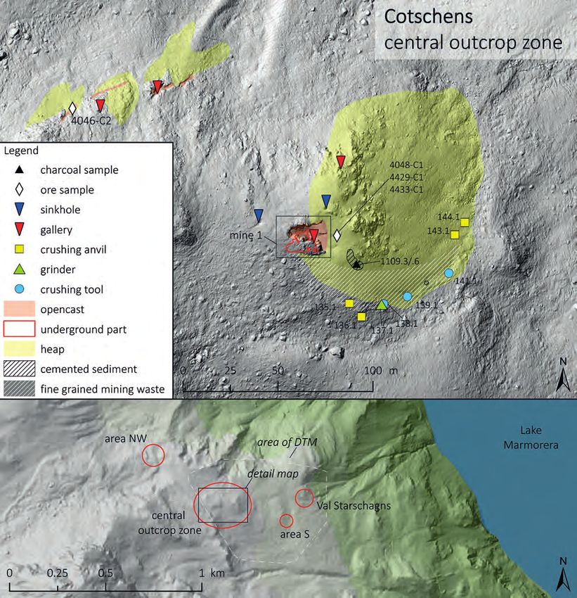
124                                                  Leandra Reitmaier-Naef et al.

               Fig. 1. Overview of the Alpine region of Oberhalbstein, showing the sites described in the text (Map: L. Reitmaier-Naef, UZH; geodata:
               Federal Office of Topography and Canton of Grisons).

               and livestock farming. The Oberhalbstein has played an im-               dates to the Late Bronze Age.3 However, mining activity in
               portant role as an Alpine transit route at the latest since the          the region seems to have reached its peak in the Early Iron
               Middle Bronze Age, connecting Domleschg and the Albula                   Age, when dozens of smelting sites and several mines were
               Valley in the north to Engadin and the Bergell Valley in the             established on the upper valley step.4 Written sources for
               south, by way of the Julier and Septimer passes.2                        historical ore mining in the Oberhalbstein begin in the Late
                   Early evidence of local copper production – smelting
               sites and single finds of smelting slag in settlement contexts –
                                                                                        3Wyss 1993. – Schaer 2003. – Fasnacht 2004. – Wyss 2004.
                                                                                        4Turck, Della Casa, Naef 2014. – Reitmaier-Naef, Turck,
               2   Rageth 1986.                                                         Della Casa 2015. – Della Casa, Naef, Turck 2016.

4-ArchA104-2020-Reitmaier et at.indd 124                                                                                                                11.11.2020 13:17:36
Mining at the Fringes. High-Altitude Prehistoric Copper Mining in the Oberhalbstein Valley (Grisons, Switzerland)
Mining at the Fringes. High-Altitude Prehistoric Copper Mining in the Oberhalbstein Valley                  125

                   Middle Ages but only sporadically document the following               is normally partially flooded. After the cavity had been
                   centuries, leaving the scope of the mining activity unknown.           drained, a substantial part of the mine was accessible for ar-
                   All of Grisons was finally seized by a full-blown mining               chaeological investigations for the first time. In addition to
                   boom during the industrialization of the early 19th century.           a detailed documentation of the mine, a complex profile of
                   However, in view of the unprofitable nature of most of the             the underground area could be uncovered, documented and
                   mines, this came to an end towards the middle of the 19th              sampled. The results of these studies are presented below.
                   century, and apart from manganese mines during the world
                   wars, there has been no mining activity in the Oberhalbstein           2. Avagna-Ochsenalp
                   region since.5                                                         2.1. Mining Site
                       Prehistoric mining activity was focused around iron-               The area known as Ochsenalp is situated between the main
                   rich sulfidic copper ore, which crops out in several areas             valley and the Val d’Err, which lies to the east and parallel
                   of the valley. These mineralizations are found only in the             to the main valley (Fig. 2). Here, the mining site Avagna
                   upper Pennine Platta nappe, which is comprised primarily               (l’Avagna, Romansh: (ore) vein) is one of the few known
                   of ophiolites. The mineralizations are mainly contained in             copper mineralizations on the lower valley step. This site
                   serpentinite sequences, more rarely in metabasalt.6                    has long been considered the potential source of raw ma-
                       Evidence of prehistoric metal production in the Ober-              terials for the many known prehistoric smelting sites in the
                   halbstein region has been known since the beginning of                 lower part of the valley.9
                   the 20th century. In recent years, it has been the subject of              Written sources attest to the relatively intensive histori-
                   systematic investigation by the University of Zurich’s De-             cal usage of the Avagna site compared to other mining sites
                   partment of Prehistory, as part of the international research          in the valley. The earliest written evidence for historical
                   project ‘Prehistoric copper production in the Eastern and              mining in the Oberhalbstein region is an agreement between
                   Central Alps’. The field work completed between 2013 and               members of the local ministerial family ‘von Marmels’ on
                   2018 included extensive surveys as well as excavations in the          the usage of the ore veins in the Val d’Err, which dates to the
                   areas of known smelting sites around Lake Marmorera, on                year 1338 AD.10 The locality is named ‘Jsenberg11 … Emede’,
                   the upper valley step.7                                                indicating that the extracted ore was not only used for cop-
                       While there had previously been no direct archaeolog-              per at this point, but also for iron production. Despite the
                   ical evidence of prehistoric mining activity in the investi-           mineral royalties staying in the hands of the von Marmels
                   gated area, today at least four mines8 and several as yet un-          for a further two hundred years, no further documentation
                   studied or inaccessible potential sites are known. Two of              for the duration and the extent of mining activity in Avag-
                   the most striking mining sites, situated well above the forest         na-Ochsenalp is known.12 Several mines on the lower valley
                   line, are Avagna-Ochsenalp (Tinizong GR) and Cotschens                 step are mentioned in the 1606 records of a mining judge
                   (Marmorera GR) (Fig. 1). Both sites were first studied more            named Gadmer,13 although the location of these mines is un-
                   closely in August 2017 by an international team. In advance            known today. It is unclear whether Avagna-Ochsenalp was
                   of the field work, high-resolution orthophoto and terrain              not in use at this point, or if there are other reasons for it not
                   models (SfM) of both mining sites were taken with the aid              being included in these records. It is certain, however, that
                   of a drone. These served as a basis for further work and sur-          the mineralization on the Ochsenalp was periodically ex-
                   veys. Subsequently, the two sites were subjected to a mining           ploited in the first third of the 19th century. Beside iron and/
                   archaeological survey in order to describe, map and pho-               or copper, vitriol was also extracted from the sulphidic ores
                   tograph the numerous structures and features in detail and             of the Ochsenalp at this time. The ruins of the Cruschetta
                   to sample the localized mineralizations for geochemical and            vitriol factory, situated at the end of the Val d’Err (Fig. 2),
                   mineralogical investigations. Small trenches were opened at            as well as the partially preserved road for ore transportation
                   archaeologically promising spots within the heaps of both              between Avagna and Cruschetta, attest to this.14 Mining ac-
                   sites. The main focus, however, was on the initial investi-            tivity in Avagna came to an end in the 1830s at the latest.
                   gation of mine 1 in Cotschens, whose underground part                  This is indicated by both the lack of written mining records

                   5  Brun 1987.                                                          9 Rageth 1986. – Wyss 1993.
                   6  Dietrich 1972. – Peters, Dietrich 2008.                             10 Hitz 2012.
                   7 Della Casa, Naef, Turck 2016. – Turck 2019.                          11 Jsenberg or Eisenberg means iron mountain in German.
                   8 Besides the two sites presented here: Gruba II (Marmorera GR),       12 Brun 1987.
                   see Turck et al. 2018. – Vals (Marmorera GR), see Reitmaier-Naef,      13 Brügger 1866.
                   Turck, Della Casa 2015.                                                14 Brun 1987.

4-ArchA104-2020-Reitmaier et at.indd 125                                                                                                                11.11.2020 13:17:36
Mining at the Fringes. High-Altitude Prehistoric Copper Mining in the Oberhalbstein Valley (Grisons, Switzerland)
126                                                Leandra Reitmaier-Naef et al.
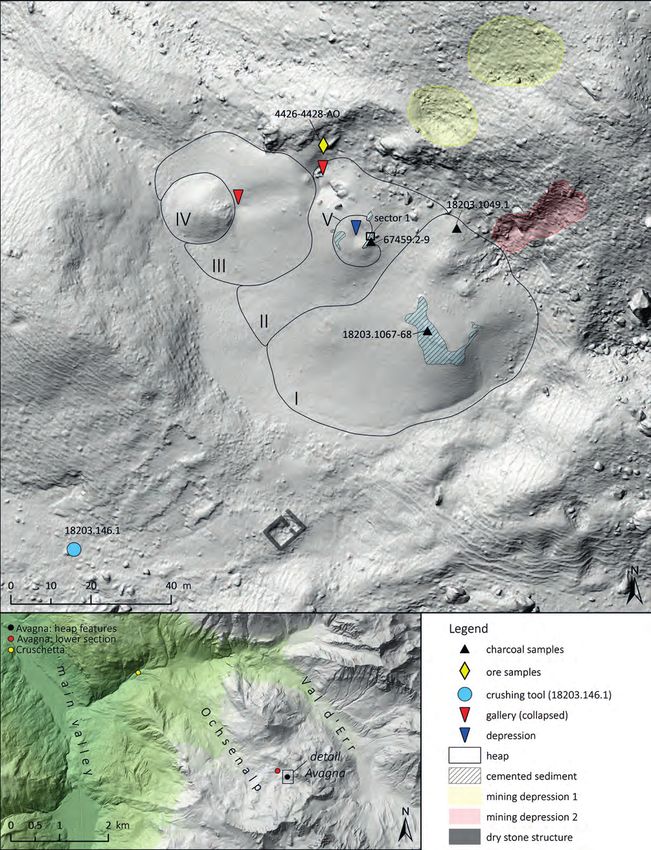
                    Avagna-Ochsenalp
                    heap features

               Fig. 2. Avagna-Ochsenalp, map of the described structures, finds and samples (Map: L. Reitmaier-Naef, UZH; terrain model: A. Zwicky and
               Ch. Walser, ADG; geodata: Federal Office of Topography and Canton of Grisons).

4-ArchA104-2020-Reitmaier et at.indd 126                                                                                                                 11.11.2020 13:17:37
Mining at the Fringes. High-Altitude Prehistoric Copper Mining in the Oberhalbstein Valley (Grisons, Switzerland)
Mining at the Fringes. High-Altitude Prehistoric Copper Mining in the Oberhalbstein Valley                 127

                   Fig. 3. Avagna-Ochsenalp, panorama of the upper section of the site with heap features (Photo: P. Thomas, DBM).

                   and the description of abandoned, inaccessible mines in                 characterized by an intensive red colouring and a predomi-
                   slightly younger geological literature.15                               nance of fine-grained mining waste.
                                                                                                A stratigraphically younger heap (III) adjoins the two
                   2.2. Description of the Mining Structures                               older heaps at the northwestern end of the site. It is roughly
                   The site is situated in the upper part of the Ochsenalp area,           circular and has a diameter of 40 m. The top of heap III is
                   which opens to the northwest, and can be divided into an                also flattened, and a disturbance of the older, covered heap
                   upper and a lower section. These sections are separated by a            (II) runs from this plateau towards the northeast. Parts of
                   distance of around 100 m (Figs. 2–3).                                   the older heap were apparently removed, exposing sections
                        The upper section is situated at approximately                     of the bedrock. The mining waste in heap III is significant-
                   2480 masl16. Characterized by a large heap which stands out             ly yellower, the characteristic red only occurring on its
                   from afar due to its striking red colouring, it lies halfway up         southeastern side. In addition, an elongated depression runs
                   the northeastern flank of the valley. A clearly defined step in         across the surface of the heap, beginning at the upper edge
                   the terrain to the southwest and northwest separates it from            and continuing down the slope in a west-southwest direc-
                   the slope below. The maximum extent of the area parallel to             tion.
                   the slope is approximately 100 m from northwest to south-                    Another, younger heap (IV) lies below the linear depres-
                   east, and approximately 70 m from northeast to southwest.               sion and covers the lower part of heap III. This heap is also
                   The heap is not uniform, its shape and coloration show that             circular, with a diameter of 17 m and a mostly yellow col-
                   it in fact consists of several features which follow each other         ouring, with grey in the northwest area. The mining waste
                   both chronologically and spatially (Fig. 3).                            on its surface is finely grained, interspersed with larger stone
                        One of the oldest features is a heap (I) which occupies            blocks which show evidence of drill holes from blasting
                   the southeast of the site over an area of 40 × 65 m. Its up-            work (Fig. 4).
                   per section is a flattened plateau which holds debris from                   The fifth feature (V) lies to the south of the disturbance
                   the slope above. Several isolated piles of rocks and mining             in heap II, slightly beneath its peak. It is crescent shaped,
                   waste are grouped around it. A similar plateau lies around              with a width of 14 m, and borders a depression with a di-
                   15 m northwest of the first heap. It can be assumed that                ameter of 4 m. Feature V is stratigraphically younger than
                   this is a second, comparable heap (II). This heap has been              feature II. Due to the lack of overlap with the other features,
                   disturbed by stratigraphically younger features, making its             its temporal relation to them cannot be determined.
                   original extent difficult to determine. The older features are               Beginning above the heaps, two features follow the
                                                                                           slope upwards to the north. The northwestern feature
                   15   E.g. Theobald 1862.                                                (mining depression 1) is comprised of several depressions
                   16   Metres above sea level.                                            which can be followed over a length of approximately 50 m.

4-ArchA104-2020-Reitmaier et at.indd 127                                                                                                               11.11.2020 13:17:38
Mining at the Fringes. High-Altitude Prehistoric Copper Mining in the Oberhalbstein Valley (Grisons, Switzerland)
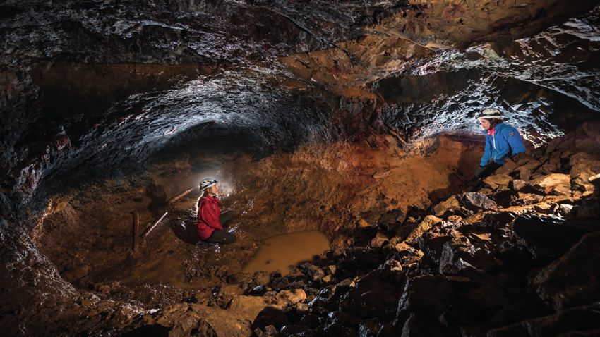
128                                                  Leandra Reitmaier-Naef et al.

                                                                                     near the rectangular building suggest that this group of finds
                                                                                     may be connected to mining activity. However, in what pe-
                                                                                     riod these structures were in use remains undetermined at
                                                                                     this point.

                                                                                     2.3. Description of the Findings
                                                                                     Almost the entire area surrounding the heaps of the upper
                                                                                     section, especially the steep slopes, is covered with fine,
                                                                                     loose rubble. The red colour of the largest heaps (I and II) is
                                                                                     most intense on the surface and changes to a yellow-grey or
                                                                                     ochre-yellow shade in the layers beneath.
                                                                                         The mining waste appears as compact, layered, brec-
                                                                                     cia-like cemented sediment in the upper areas of heaps I and
                                                                                     II, especially at the edges of the plateaus (Fig. 5). Regular-
                                                                                     ly occurring charcoal fragments und negative imprints of
                                                                                     wood splints are found in these areas. Some of the wood
                                                                                     imprints from the edge of heap I have square or rectangular
                                                                                     cross sections of 3–8 mm and are occasionally found in pairs
                                                                                     (Fig. 6).
               Fig. 4. Avagna-Ochsenalp, large stone blocks on heap IV with drill
               holes from blasting work (Photo: P. Thomas, DBM).                         An area of mining waste in the northwest of the heap
                                                                                     features was excavated in a sector of 1.5 × 2 m, the stratig-
                                                                                     raphy was documented and sampled (Figs. 2, 5, sector 1).
               The southeastern feature (mining depression 2) is a distinct          These layers belong stratigraphically to the older heap II
               trench of around 25 m in length.                                      and not to the younger, crescent-shaped heap V. The trench
                   A final feature in this area of the site is the dry-stone         revealed a sequence of layers of differing thickness, which
               walls of a building, which lie approximately 20 m to the              also differ significantly in their composition. The layers run
               south of the heaps (Fig. 2). The 10 × 6 m structure built of          horizontally or at a slight downhill slant. The uppermost
               rough stone blocks contains a visible partition wall, which           20–30 cm are the most compactly cemented, and mainly
               indicates the division of the interior into at least two rooms.       consist of rubble (1–10 cm) that shows varying degrees of
                   A hand-held crushing tool, a so-called pestle (Fig. 19,           weathering. The polished section of a micromorphologi-
               18203.146.1), was found on the slope below the building               cal block sample (67459.4.1) of this area reveals a stratified
               structure. This is the only artefact found in this area of the        sequence with layers a few centimetres thick. Beneath this
               site. The raw material is an augite-biotite-diorite, a pluton-        cemented upper part lies a noticeably looser, subhorizon-
               ic rock possibly originating from the bedrock of the Err              tally bedded deposit of 10–20 cm thickness. It contains iso-
               nappe, which lies above the site. The artefact was artificially       lated charcoal fragments (5–50 mm), and partially burned,
               worked into a rounded, flattened shape. It has a relatively           fine-grained reddish sediment. Below this follows a more
               regular diameter of 10 cm and weighs just under 600 g. Trac-          compact layer which contains rock fragments up to 20 cm
               es of use are visible on the worn edges of the tool.                  in diameter.
                   The lower section of the site lies at approximately                   The polished section of a micromorphological sample
               2410 masl, northwest and down-slope, at the foot of the               from the uppermost layer of the edge of heap I shows a sim-
               terrain step which borders the heap features in the upper             ilar composition and an even more pronounced stratifica-
               area of the site. Several building structures and small heaps         tion (Fig. 7, 18203.115.1). These deposits, consisting mainly
               are found in this area, which extends over 125 m from east            of weathered greenish to brownish serpentinite fragments
               to west and reaches 50 m at its widest point. The former are          (ultramafic bedrock) are strongly cemented by iron hydrox-
               two round buildings which are sunk into the ground, and               ides. The angular rock fragments (0.1–2 cm) generally occur
               the foundations of a smaller, rectangular building. One of            as elongated flakes and contain occasional ore inclusions
               the round structures shows evidence of burning on the inner           (chalcopyrite or pyrite). The uppermost layer is dominated
               walls. The heaps have a distinctive red colouring, and one            by big, well-preserved and subangular charcoal fragments
               contains a noticeable amount of stones with secondary cop-            (1–20 mm). Interestingly, in the central area of the sample,
               per mineralization. The heaps and a possible gallery situated         there are indications of a trampled surface on top of layer 4,

4-ArchA104-2020-Reitmaier et at.indd 128                                                                                                           11.11.2020 13:17:39
Mining at the Fringes. High-Altitude Prehistoric Copper Mining in the Oberhalbstein Valley (Grisons, Switzerland)
Mining at the Fringes. High-Altitude Prehistoric Copper Mining in the Oberhalbstein Valley                       129

                   Fig. 5. Avagna-Ochsenalp, area of oldest heap features with solidi-     Fig. 6. Avagna-Ochsenalp, negative imprint of two wood shavings
                   fied ridges, view to southeast. – In foreground: documented sector 1    (picture centre; width: 4 mm) – presumably lighting tapers – from
                   with heaps II and V (Photo: P. Thomas, DBM).                            the upper cemented area of heap I (Photo: P. Thomas, DBM).

                                                                                              1

                                                                                              2

                                                                                              3

                                                                                              4                                    1 Charcoal layer
                                                                                                                                   2 Layer of weathered, angular
                                                                                                                                     serpen�nite fragments
                                                                                                                                   3 Horizontally oriented
                                                                                                                                     serpen�nite fragments with
                                                                                              5                                      loamy groundmass.
                                                                                                                                     Ac�vity area (?)
                                                                                                                                   4 As layer 3, with compacted
                                                                                                                                     (trampled?) surface
                     0                                5 cm                                                                         5 Weathered serpen�nite
                                                                                                                                     fragments

                   Fig. 7. Avagna-Ochsenalp, polished section of a micromorphological sample from the cemented area of heap I, showing delineated layer
                   boundaries (Photo and illustration: J. Bucher, UZH).

                   in the form of compacted sediment and horizontally orient-              waste, presumably from an area west of and below the
                   ed components.17 Layer 3 shows similar features and prob-               building structure. Three new 14C samples of cemented sed-
                   ably represents an activity area.                                       iment from heap I (18203.1067–68, 18203.1049.1) also date
                                                                                           to the Late Bronze Age (Fig. 8). However, due to the lack of
                   2.4. Dating                                                             waney edges and sapwood, it is not possible to estimate how
                   Previous research had yielded a Late Bronze Age 14C date                accurately these samples date the mining activities. In view
                   for Avagna-Ochsenalp18 from a charcoal fragment found                   of the narrow growth of the tree rings, a single year as well
                   in what is apparently a piece of smelting slag. However, an             as even entire centuries could be missing.
                   appraisal of the original sample material showed that it was                Newer samples of the mining waste from heap II tak-
                   not slag, but a piece of the aforementioned cemented mining             en for the present study proved more suitable for dendro-
                                                                                           chronological dating. A mean curve was constructed of a
                                                                                           total of 25 charcoal fragments (Fig. 8, 67459.2–9), the end
                   17  Rentzel et al. 2017.
                   18  Wyss 1993, 202: B-4188: 2990 ± 90 BP; 1433–976 calBC (2σ) [new      year being 1043 BC. Short sequences were only taken into
                   calibrated].

4-ArchA104-2020-Reitmaier et at.indd 129                                                                                                                     11.11.2020 13:17:40
Mining at the Fringes. High-Altitude Prehistoric Copper Mining in the Oberhalbstein Valley (Grisons, Switzerland)
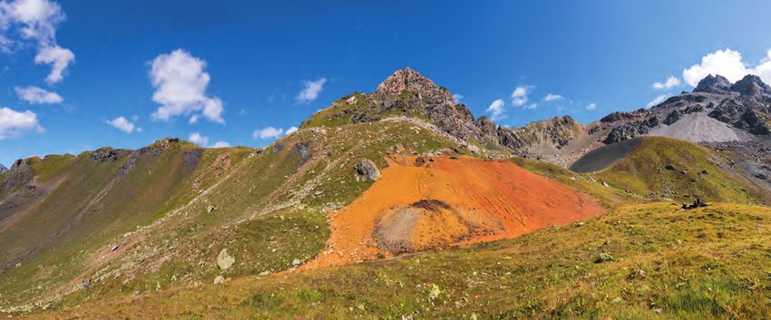
130                                                                                                      Leandra Reitmaier-Naef et al.

                 a)                                                                                                                                                                               overlapping mean curves
                                                                                                                                                                                                  3187 (Höhenbiel 6, Larix decidua)
                                                                                                                                                                                                  5096 (Avagna-Ochsenalp, conifera)
                                                                                                                                                                                                  Gleichläufigkeit: 59.4%
                                                                                                                                                                                                  t-value (a�er Hollstein): 6.7

                                                                                                                                                                                                  find no.          sample no.
                                                                                                                   -5                                                    - 43                     67459.9.4        88692
                      legend                                                                                  -9                                                  - 58                            67459.2.5        88633
                      first tree ring                   last tree ring
                                                                                                - 19                                                             - 59                             67459.2.16       88644
                                                                                                                         - 96                                  - 61                               67459.2.7        88635
                                          heartwood
                                                       ending with                                        - 12                                                 - 61                               67459.2.25       88653
                                                       heartwood
                                                                                                                  -7                                           - 61                               67459.8.5        88687
                                       wane autumn/winter
                                                                                                    - 16                                                       - 61                               67459.9.1        88689
                                                                                                                  -7                                          - 62                                67459.5.1        88658
                                                                                                                   -6                                        - 63                                 67459.5.2        88659
                                                                                              - 21                                                           - 63                                 67459.6.1        88671
                                                                                                                    -4                                     - 65                                   67459.2.20       88648
                                                                                            - 23                                                         - 67                                     67459.2.9        88637
                                                                                                                   -6                                  - 69                       heap II         67459.2.11       88639
                                                                                                                  -8                                 - 71                                         67459.6.5        88675
                                                                                                                        -2                           - 71                                         67459.9.7        88695
                                                                                                   - 17                                          - 75                                             67459.5.5        88662
                                                                                                           - 12                                 - 76                                              67459.5.11       88668
                                                                                                          - 13                                - 78                                                67459.2.28       88656
                                                                                                - 19                                         - 78                                                 67459.8.2        88684
                                                                                                                        -2                  - 79                                                  67459.2.19       88647
                                                                                                                       -3                   - 79                                                  67459.2.27       88655
                                                                                                   - 18                                   - 81                                                    67459.6.4        88674
                                                       - 61                                                                             - 83                                                      67459.9.3        88691
                                                                 - 54                                                         -5                                                                  67459.6.8        88678
                        - 86                                                                                           - 11                                                                       67459.6.6        88676

                                - 79                                                                                   - 12                                                       heap I          18203.1049.1     87897

                                                                                                       14C-sample ETH-86921 (tree rings 57-68)

                                                                        1150                                            1100                                    1050                        1000 BC

                 b)                                                                                                                                                                               18203.1068
                                                                                                                                                                                                  space
                                                                                                                                                                                                                   ETH-63990
                                                                                                                                                                                                  date: 3088 ± 16 BP
                                                                                                                                                                                                  2-σ (95.4%): 1414-1296 cal. BC

                                                                                                                                                                                                  18203.1067
                                                                                                                                                                                                  ace
                                                                                                                                                                                                                   ETH-63993
                                                                                                                                                                                                  date: 3015 ± 16 BP
                                                                                                                                                                                  heap I
                                                                                                                                                                                                  2-σ (95.4%): 1375-1209 cal. BC

                                                                                                                                                                                                  18203.1049.1
                                                                                                                                                                                                  ace
                                                                                                                                                                                                                   ETH-86921
                                                                                                                                                                                                  date: 2973 ± 21 BP
                                                                                                                                                                                                  2-σ (95.4%): 1261-1122 cal. BC

                                                      1400                         1300                                   1200                   1100                      1000              900 cal. BC
                OxCal v4.3.2 Bronk Ramsey (2017); r:5 IntCal13 atmospheric curve (Reimer et al 2013)

               Fig. 8. Avagna-Ochsenalp, absolute dates. – a. Cross-correlation and dendrochronological dating of mean curve 5096 and bar chart of all 25 se-
               ries from heaps I and II. – b. 14C dates of charcoal fragments from heaps I and II (Illustration: L. Reitmaier-Naef, UZH).

               account if other samples from the same layer had more than                                                                         However, definitive activity in Avagna can be dated at the
               50 tree rings. Waney edges are generally difficult to detect in                                                                    earliest to 1043 BC, based on the later end year dates.
               charcoal fragments; experience has shown that within dat-                                                                               The dendrochronological date of a charcoal fragment
               ed sample groups there are sometimes waney edges that are                                                                          (18203.1049.1) from heap I was gained with the help of a
               older than the youngest end year, indicating the sporadic                                                                          14
                                                                                                                                                     C dating to the end year 1112 BC (without a waney edge)
               use of old wood.19 Here, bast remains confirm the only defi-                                                                       (Fig. 8). This series correlates with the samples from heap II.
               nite waney edges, which dates to the year 1061 BC (Fig. 9).                                                                        Due to the fact that most of the waney edges are missing, it
                                                                                                                                                  is chronologically possible, but not absolutely certain, that
                                                                                                                                                  the heaps are contemporaneous.
               19     Oberhänsli et al. 2019.

4-ArchA104-2020-Reitmaier et at.indd 130                                                                                                                                                                                              11.11.2020 13:17:40
Mining at the Fringes. High-Altitude Prehistoric Copper Mining in the Oberhalbstein Valley (Grisons, Switzerland)
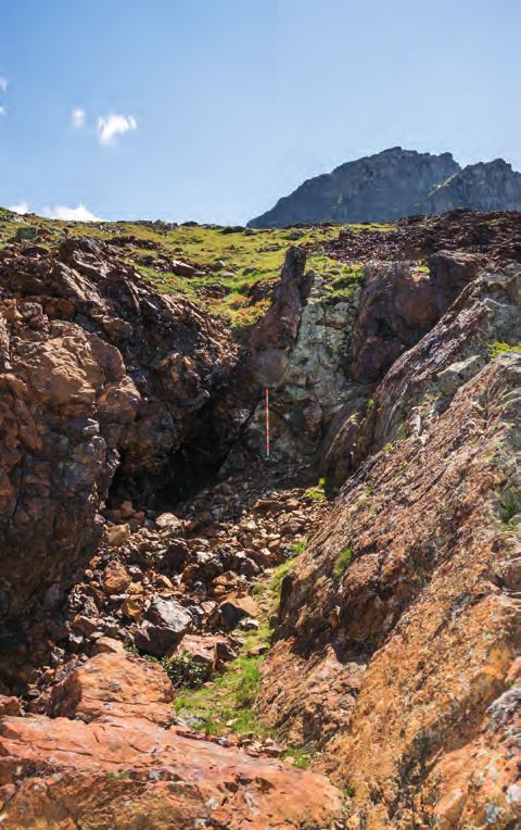
Mining at the Fringes. High-Altitude Prehistoric Copper Mining in the Oberhalbstein Valley                    131

                                                                                          Fig. 10. Avagna-Ochsenalp, cross sections (reflected light). – Ore
                                                                                          Sample 4428-AO (left): pyrite (Py), largely replaced by chalcopyrite
                                                                                          (Cp). – Ore Sample 4426-AO (right): pyrite with small amounts of
                                                                                          chalcopyrite spreading along the fractured edges
                                                                                          (Photos: L. Reitmaier-Naef, UZH).

                   Fig. 9. Avagna-Ochsenalp, sample 67459.2.25 (reflected light):
                   waney edge confirmed by bast remains, dated to 1061 BC (Photo:
                   W. H. Schoch, Laboratory for Ancient Wood Research, Langnau                While both mineralizations may have been of interest
                   am Albis).                                                             for the vitriol mines of the modern period, it can be assumed
                                                                                          that only copper ore was mined and processed in the prehis-
                                                                                          toric period. However, it is unclear if or how well both types
                   2.5. Mineralization                                                    could be separated during the mining process. The copper
                   The mineralized outcrop in Avagna is one of the most cop-              produced from this ore cannot be definitively characterized
                   per rich mineralizations in the Oberhalbstein region. Be-              with a single general chemical analysis, but it would be gen-
                   cause the bedrock of the site is almost completely covered             erally low in trace elements and – in contrast to copper from
                   by the heap features, the mineralization is only visible in            the upper valley step (see section 3.7) – it would not contain
                   the terrain to the north of the mining area. It lies roughly           high Ni levels (Tabs. 1a–1b).
                   horizontally in a heterogenous fault zone in the upper Platta
                   nappe. Two distinct areas can be differentiated within the             2.6. Interpretation
                   ore mineralization. The footwall comprises mainly pyrite               Written sources attest to mining activity in Avagna-Ochsen­
                   (FeS2) in a chloritic-calcitic matrix, while the hanging wall          alp from the Middle Ages at the latest. Existing radiocarbon
                   contains a larger concentration of chalcopyrite (CuFeS2) in a          data from earlier studies suggested older, prehistoric phas-
                   mylonitic matrix of chlorite, muscovite and quartz.20 Com-             es of use, which led to the mining archaeological survey in
                   pared with other locations in the Oberhalbstein, the miner-            2017.
                   alization in Avagna-Ochsenalp is mineralogically relatively                 The most prominent features are the multi-phased heaps
                   simple. The lack of ore minerals such as pyrrhotite (FeS) or           of the upper section. The evaluation of a detailed digital ter-
                   magnetite (Fe3O4), which appear regularly in typical serpen-           rain model allowed at least five separate heaps to be identi-
                   tinite mineralizations in the Oberhalbstein, is particularly           fied, which can be assigned to at least two different oper-
                   noticeable.                                                            ating phases. The two oldest, largest heaps date to the Late
                       Three ore samples were taken from the northern border              Bronze Age. The tops of these heaps have been flattened
                   of the heap features of Avagna-Ochsenalp, where remains                to plateaus. The sediment on the plateaus is compact and
                   of the mineralization can be found in situ. They represent             finely layered, which allows an interpretation as a trampling
                   the two distinct areas of the mineralization (Fig. 10):                surface. Presumably, these are the peaks that lay directly in
                       1. The samples 4426-AO and 4428-AO both primari-                   front of and functioned as access areas to the mines that are
                   ly contain pyrite, which is reflected in high FeO and S and            found in the adjoining mining depressions.
                   low Cu levels in the overall chemistry. In polished sections                The Bronze Age heaps make up the bulk of the features,
                   chalcopyrite has been accordingly observed only in minor               while the heaps from later activities are less extensive. They
                   amounts, replacing pyrite along fractured edges.                       lie at the northwestern edge of the terrain and, due to their
                       2. In contrast, ore microscopy showed no pyrite in sam-            location and size, can be interpreted as the results of later
                   ple 4427-AO. The sample contains only chalcopyrite, as in-             prospections and clearing-up efforts. The older heaps were
                   dicated by the corresponding Cu and S levels of the analysis.          partially disturbed or repositioned during these activities.
                   The gangue material of this mineralization is quartz.                  Only the youngest phase can be dated with certainty; due
                                                                                          to the use of gunpowder, this phase can be placed in the
                   20   Dietrich 1972.

4-ArchA104-2020-Reitmaier et at.indd 131                                                                                                                  11.11.2020 13:17:48
Mining at the Fringes. High-Altitude Prehistoric Copper Mining in the Oberhalbstein Valley (Grisons, Switzerland)
132                                                      Leandra Reitmaier-Naef et al.

                    Sample        SiO2     TiO2   Al2O3   FeO    MgO      MnO     CaO    Na2O     K2O    P2O5     S      Cu     ZnO     Sum
                 4426-AO           16,0    0,29   11,16   43,6   2,53      0,05   0,01    0,04    0,97   0,01   22,78    0,72   0,02     98
                 4427-AO           57,1    0,20   5,27    14,1   2,27      0,08   0,89    0,03    0,12   1,08    3,32    3,26   0,01     88
                 4428-AO            9,5    0,10   8,11    43,8   3,26      0,04   0,01
Mining at the Fringes. High-Altitude Prehistoric Copper Mining in the Oberhalbstein Valley                    133

                   Fig. 11. Cotschens, maps of the mines, heaps, finds (18203.[…]), charcoal samples (18203.[…]) and ore samples (Map: L. Reitmaier-Naef, UZH;
                   terrain model: A. Zwicky and Ch. Walser, ADG; geodata: Federal Office of Topography and Canton of Grisons).

                   Central Outcrop Zone                                                    archaeology. Here, the outcrop zone extends over an area of
                   The largest area of activity lies at a central position in the          70 × 65 m. A heap measuring 120 × 60 m lies in front of this
                   terrain and is visible from afar due to its extensive, striking-        to the east. Mine 1, which was archaeologically surveyed in
                   ly red mining waste heaps. This colour is eponymous for                 the summer of 2017, is situated in this area. At least two col-
                   the entire mining area of Cotschens (cotschen, Romansh:                 lapsed portals, a sinkhole directly northeast of mine 1 and a
                   red). The area is divided into an eastern and a western part,           similar depression 16 m to the west of the mine all indicate
                   the eastern part being more productive in terms of mining               further underground mining activity. Cemented sediment,

4-ArchA104-2020-Reitmaier et at.indd 133                                                                                                                  11.11.2020 13:17:51
134                                                  Leandra Reitmaier-Naef et al.

               which contains numerous fragments of wood and charcoal,               Area NW
               is found around the heap, especially southeast of mine 1.             A smaller, previously completely unknown mining area
               The upper and middle part of the southern side of the heap            lies roughly 250 m northwest of the central outcrop zone.
               contains comparatively fine material. Based on the stone              It comprises several features: an elongated trench runs
               tools found here, this area could be interpreted as a process-        west-southwest to east-northeast over approximately 30 m,
               ing site, which is a unique find so far in the Oberhalbstein          an approximately 65 × 20 m heap of noticeably fine-grained
               region (Fig. 11).                                                     material adjoins the trench to the north, and a small but
                   In the western part of the area, the outcrop stretches            pronounced southwest-northeast striking trench, which
               over 120 × 60 m. Heaps are found mainly to the northeast              consists of three mining depressions of up to 10 m in size is
               and to a lesser extent to the northwest. Traces of mining are         situated in the eastern part of the area.
               found here mainly as mining depressions and trenches that
               follow diabase dykes which strike from northeast to south-            3.2. Description of Mine 1
               west (Fig. 12), as well as isolated collapsed portals which           The mine is situated at the southern edge of the eastern part
               seem to follow the direction of the dykes. Finally, at the            of the central outcrop zone. It consists of two main parts: an
               northwestern edge of the outcrop, there are several small             elongated opencast and an underground part which adjoins
               test trenches.                                                        to the south.
                                                                                         The opencast strikes in an east-west direction for around
                                                                                     20 m (Fig. 13). Its widest point of 12 m lies at the eastern,
                                                                                     down-slope end. As it extends up the slope, it narrows to
                                                                                     around 6 m and ends in a working face that is around 3 m
                                                                                     high. The northern side wall also has a height of around 3 m
                                                                                     and inclines noticeably to the south, especially in the back,
                                                                                     western end of the opencast. At the eastern end, the wall
                                                                                     is set more to the north over a length of 5 m, and slightly
                                                                                     undercut. The southern side wall is slightly higher than its
                                                                                     northern counterpart. However, because the infill of the
                                                                                     opencast slopes to the south, the southern side wall rises
                                                                                     significantly higher and reaches a height of up to 5 m. It is
                                                                                     almost vertical and in places also slightly undercut.
                                                                                         Due to the fissured rock, the surfaces of the side walls
                                                                                     are very irregular, making traces of mining work difficult
                                                                                     to detect. Rounded forms have only been preserved in a few
                                                                                     places in the harder areas of the rock, especially on the south
                                                                                     wall and on the western working face.
                                                                                         The opencast mine is partially filled with rubble, which
                                                                                     covers the entire floor of the mine. The sediment generally
                                                                                     inclines to the east and south. In the eastern area, several
                                                                                     boulders protrude from the sediment; some are collapsed
                                                                                     blocks, while others seem to be part of the bedrock. This
                                                                                     also seems to be the case for a low step that runs through the
                                                                                     middle of the mine, following the line of strike. A massive
                                                                                     rock spur to the southwest of this forms a northeast-south-
                                                                                     west wall, which only shows traces of deep incisions at its
                                                                                     southwestern end and is thus separated from the southern
                                                                                     wall of the mine. On its southeastern side, a rounded mining
                                                                                     feature undercuts the spur in a western direction. However,
                                                                                     the full extent of this feature cannot be determined due to
               Fig. 12. Cotschens, view of an undated mining trench in the
                                                                                     the infill.
               north-western area of the central outcrop zone, which follows a
               diabase dike (pale stone, center of image). View to southwest             In the area surrounded by the described structures, the
               (Photo: P. Thomas, DBM).                                              surface of the infill is markedly lower than in the rest of the

4-ArchA104-2020-Reitmaier et at.indd 134                                                                                                           11.11.2020 13:17:53
Mining at the Fringes. High-Altitude Prehistoric Copper Mining in the Oberhalbstein Valley                  135

                   opencast, the difference in height reaching up to 3 m in some          especially in the area of the walls, the material is so solidified
                   areas. The entrance to the underground part of the mine is             that it is almost impossible to remove it manually.
                   situated here, lying at the foot of the south wall and opening             The underground part of mine 1 is currently flooded;
                   to the southwest.                                                      water fills the entire lower area of the stope. The flooding
                        The entrance to the underground part from the opencast            contributed to the good preservation of the wooden ob-
                   is around 9 m wide. Most of this, however, is filled with rub-         jects. After the stope had been drained, a layer of mud a
                   ble which has entered the mine from the opencast. Access               few centimetres thick remained. Most of the wooden arte-
                   to the mine is only possible from the east, where the infill           facts were found in this layer. Many of them were probably
                   is lower.                                                              moved by the water and date from different periods of use.
                        The underground part of the mine inclines by 20° to the           A trough, of which more than half was preserved (Figs. 16,
                   west-southwest and has a length of 17 m. The total height              18, 67457.22.1) was found on the floor of the small drift in
                   is around 8 m, and the maximum width reaches 12 m in the               the northern wall.
                   line of strike (Fig. 14). The mine comprises several domed                 In a small, raised recess in the southern wall of the lower
                   working sections which intersect and are arranged in a lin-            stope, sediment was preserved between the mud layer and
                   ear fashion along the incline. At least three such structures          the bedrock. This was excavated manually and documented
                   can be differentiated. Their roofs are domed, but the walls            (Fig. 14, sector 2). The up to 5 cm-thick sediment consist-
                   are partially segmented into smaller structures with further           ed of partially oxidized, fine angular rock fragments. This
                   domes and recesses, most prominently in the central area of            layer also contained several charcoal fragments and further
                   the south wall of the mine. Two structures which seem to               wooden artefacts, including a spatula (Fig. 18, 67457.38.1)
                   differ from this principle extend the mine to the north. A             in situ.
                   small drift is situated at the mine’s lowest point and extends             The largest outcrop is situated in the upper area of the
                   from the north wall for around 1.5 m to the north. While the           mine, between the portal and the northern wall (Fig. 14,
                   cross section is rounded, the ground plan is clearly rectan-           sector 3). From here, the infill inclines sharply from the
                   gular. A larger drift in the upper section of the mine shows           roof to the southwest into the mine. The loose rubble on
                   similar characteristics. This drift extends over 4 m to the            the surface, presumably originating from the opencast, was
                   northwest. It is considerably larger, with a width of around           removed from an area of approximately 3.5 × 3.5 m (sloping
                   4 m and a height of over 4 m. Straight walls and an irregular          over a height of almost 4 m). Several layers of older filling,
                   profile suggest that a different mining technique was used             levels with evidence of burning and stone structures were
                   here.                                                                  revealed beneath. The layers, partially cemented due to sec-
                        Large parts of the floor of the mine are covered with rub-        ondary oxidization, had been almost vertically truncated
                   ble, making it difficult to completely determine its southern          even before they were covered by the loose material. They
                   extent. Only the lowest stope and the two drifts which ex-             were generally left as found, which is why the documented
                   tend to the north are free of sediment (Fig. 15). Beginning at         profile is stepped.
                   the opencast mine, the infill slopes steeply to the southwest,             These layers are aligned horizontally south-north and
                   south and southeast. Rough rubble is concentrated at the               cover the floor in the northern part of the mine (Fig. 17).
                   foot of the incline, while the material in the upper part of           Three to four thick layers of rough infill, separated by thin
                   the mine is finer. Two large rocks found here in the infill            sediment layers containing fine charcoal, make up the lower
                   are presumably collapsed blocks from the roof of the mine.             half. Two of these thin charcoal layers are visibly reddened
                                                                                          by exposure to heat in their lower area. Two charred ani-
                   3.3. Description of the Findings in Mine 1                             mal bones were found in the uppermost layer of the two.
                   In order to study the infill in the opencast, a test trench            The roughly layered infill consists of sharp-edged serpen-
                   measuring 80 × 80 cm was opened directly at the base of                tinite rubble of varying sizes (0.5–30 cm) and proportions.
                   the southern wall (Fig. 13, sector 1). From just a few cen-            The coarse-grained, porous infill generally seems to be
                   timetres below the surface, the bedrock below is relatively            more cemented than the finer material. The deposit has a
                   flat, sloping only slightly to the east, indicating that the infill    reddish-brown to violet-black colour and shows a glossy
                   may not be very thick in the southwest part of the opencast.           surface in the cemented areas. Polished sections show that
                   It consists of heterogeneously distributed, partly sub-hori-           the dark-green serpentinite and especially the ore-bearing
                   zontally stratified serpentinite rubble (mainly 0.5–10 cm).            veins are heavily weathered, leading to a porous structure
                   The components are strongly weathered and cemented to                  or a peripheral weathering zone. At least one fragment is
                   a hard, breccia-like deposit. At a depth of around 30 cm,              completely coloured red, presumably due to exposure to

4-ArchA104-2020-Reitmaier et at.indd 135                                                                                                                11.11.2020 13:17:53
136                                                  Leandra Reitmaier-Naef et al.

                mag.   N

                                              sector 1

                                                                                                                   E

                                                                                                                            0     1                   5m

               Fig. 13. Cotschens, mine 1, opencast with underground cavity. – Top: ground plan. – Bottom: vertical projection (Plan: P. Thomas and
               G. Steffens, DBM).

4-ArchA104-2020-Reitmaier et at.indd 136                                                                                                              11.11.2020 13:17:54
Mining at the Fringes. High-Altitude Prehistoric Copper Mining in the Oberhalbstein Valley                                                   137

                                                                                                                                    a´
                                                                                                                                                                                mag.   N
                               a                                    a´

                                                                                                    d´
                                                                                                                                                           HP1
                                                                                                                                               sector 3
                                                                                          b                           b´
                                                                                                                  a
                                                                              c´
                                                                                                                                         HP2

                              b                           b´

                                                                                                                                                                              E

                                                                                          sector 2
                                                                              c
                               c                                         c´
                                                                                                   d

                              d                                                           d´

                                                                                                                                                     0       1                        5m

                                    rockline, section                                     underlying part (plan)                                          prehistoric copper-mining
                                    step line (transition to vertical)
                                                                                          sediment (section)
                                                                                                                                                                 Cotschens
                                                                                          dripline                                                         mine 1
                                    slope line (transition to horizontal)                     clastic sediment with stones, slope        opencast with underground part (left side)
                                                                                                                                               underground part (this side)
                                                                                              stone setting
                                                                                                                                                  plan, cross-section and
                                                                                              sectors of excavation                                  vertical projection
                                                                                              survey point

                                                                                      E       entrance                                            Oberhalbstein, Canton of Grisons
                                                     Survey: P. Thomas 08/17
                          Deutsches Bergbau-Museum
                          Bochum                     Computer drafting: G. Steffens
                                                                                                                                                            Switzerland

                   Fig. 14. Cotschens, mine 1, underground part with cross sections and vertical projection (Plan: P. Thomas and G. Steffens, DBM).

4-ArchA104-2020-Reitmaier et at.indd 137                                                                                                                                                   11.11.2020 13:17:56
138                                                    Leandra Reitmaier-Naef et al.

               Fig. 15. Cotschens, mine 1, lowest stope area with wood finds and small northern drift, view to the west (Photo: P. Thomas, DBM).

               Fig. 16. Cotschens, mine 1, one of the La Tène period troughs (67457.22.1) in its original position on the floor of the small drift in the northern
               side wall of the lowest stope area (Photo: P. Thomas, DBM).

4-ArchA104-2020-Reitmaier et at.indd 138                                                                                                                             11.11.2020 13:18:00
Mining at the Fringes. High-Altitude Prehistoric Copper Mining in the Oberhalbstein Valley                                                                                                                                                   139

                                                                                                                            N-NO                                                    S-SW                                  ŽƉĞŶŝŶŐ

                                                                                                                                                                                                                                                                                   ƉŽƌƚĂů
                                                                                                                                                                roof
                                                                                            ce
                                                                                                                                                                                                                                  slo

                                                                                         rfa                                                                                                           14
                                                                                                                                                                                                                                   pe

                                                                                       su
                                                                                 old
                                                                                                                                                                                                                                          su
                                                                                                                                                                                                                                              rfa

                                                                                                                                                            ĐĞŵĞŶƚĞĚ
                                                                                                                                                                                                                                                ce

                                                                                                                                                                                                                                                                                                       1m
                                                                                 ŐĞ                                                                         area
                                                                            ĞĚ                            ƐĞĐƟŽŶƐƚĞƉ
                                                        f

                                                                                                                                                                                        ƐĞĐƟŽŶƐƚĞƉ
                                                       o
                                                    ro

                                                             ĞĚŐĞ            
                                                                                                     14
                        ϭŵƚŽ                 
                                                                
                        ŶŽƌƚŚĞƌŶ
                        ŶŝĐŚĞ                                                                                                           15                                                                            16
                                                        7                                                                                                                                                                         
                                                                                                                                                                                                
                                                                                                                                                                                                                                                                          collapsed
                                                    
                                                                                        ĐĞŵĞŶƚĞĚĂƌĞĂ                                                                        
                                                                                                                                                                                                                                                                         blocks
                                                                                                                                                                        17         
                                                                                                                           29
                                                                                                                                                                                                                                                                                                       0

                                                        11                                                                      18                                                                12

                                                                                                                                                                                                                                          collapsed blocks
                                                                         ďƵƌŶƚďŽŶĞ                                                            19
                                                                         67457.36.1                                                                                                                           
                                                                                                                                                                                                                             
                                                                                                                                                                                                                                                    30
                                                                                                 21                                                                             
                                                                                                                                                                                             13            
                                                                                                                                 ƐĞĐƟŽŶƐƚĞƉ

                                                                                                                                                        
                                                                                                                                                                                        22                            
                                                     ĐŚĂƌĐŽĂůĨƌĂŐŵĞŶƚƐ                                                                                                                         

                                                          ĮƌĞƌĞĚĚĞŶŝŶŐ
                                                                                                                                                    HPЈ
                                                                                                                                                                                                                                                    
                                                                                                                                                                                                                                                                                                 ůƟƚƵĚĞ
                                                          ĞdžĐĂǀĂƟŽŶůŝŵŝƚ                                                                                                                                                                         HPЇ
                                                                                                     23


                                                                                                                                                                                                                                                                                                PЉ͵35 cm
                                                                                                                                                                                                                                          6
                                                                                                                      27                                                                                                           
                    ϭϰ                                     ĮŶĞĮůů͕ƐůŝƉƉĞĚŝŶ                                                                                                                       24


                    ϭϮ͕ϭϳ͕ϭϵ                             ƉŽƐƐŝďůĞĚƌLJǁĂůůƐƚƌƵĐƚƵƌĞƐ
                    ϭϭ͕ϭϱ͕ϭϲ͕ϭϴ͕Ϯϵ                    ĮŶĞƚŽĐŽĂƌƐĞƐƚŽŶĞĮůůŝŶŐǁŝƚŚĐŚĂƌĐŽĂůĨƌĂŐŵĞŶƚƐ͕                                                                                                                                                

                                                           ƉĂƌƚůLJĐĞŵĞŶƚĞĚ͘/ŶϭϭŵŝŶĞƌĂůŝƐĞĚǁŽŽĚĞŶƐƉŝůůƐ                                                                                      25
                                                                                                                                                                              ƐŽů
                                                                                                                                                                                   ŝĚƌ
                    ϳ                                      ĮŶĞƚŽĐŽĂƌƐĞƐƚŽŶĞĮůůŝŶŐǁŝƚŚĐŚĂƌĐŽĂůĨƌĂŐŵĞŶƚƐ͕ůĂLJĞƌĞĚ͕ƉĂƌƚůLJĐĞŵĞŶƚĞĚ                                               ŽĐŬ
                                                                                                                                                                                                                                                            28   ƒƒƒƒƒƒƒƒƒƒƒƒƒƒƒƒƒƒƒƒƒƒƒƒƒƒƒƒ
                    ϭϯ͕Ϯϭ                                 ĂĐƟǀŝƚLJƐƵƌĨĂĐĞǁŝƚŚďƵƌŶŝŶŐƚƌĂĐĞƐ͕ĐŚĂƌĐŽĂůĚƵƐƚĂŶĚĨƌĂŐŵĞŶƚƐ͕ďƵƌŶƚďŽŶĞ                                                                                                         
                                                                                                                                                                                                                                          
                    30                                      collapsed roof blocks                                                                                                                                                         31                                ŶŽƚŽŶƉŚŽƚŽŐƌĂƉŚ
                    ϲ͕ϮϮ                                  ĐŽĂƌƐĞƐƚŽŶĞĮůůŝŶŐ͕ĐĞŵĞŶƚĞĚ͕ĐŚĂƌĐŽĂůĨƌĂŐŵĞŶƚƐ͕ĮŶĞǁŽŽĚƐƉůŝŶƚƐ
                                                                                                                                                                                                                                                    
                    Ϯϯ                                     ĂĐƟǀŝƚLJƐƵƌĨĂĐĞǁŝƚŚďƵƌŶŝŶŐƚƌĂĐĞƐ͕ĐŚĂƌĐŽĂůĚƵƐƚĂŶĚĨƌĂŐŵĞŶƚƐ
                    Ϯϰ                                     ĮŶĞƚŽĐŽĂƌƐĞƐƚŽŶĞĮůůŝŶŐǁŝƚŚĐŚĂƌĐŽĂůĨƌĂŐŵĞŶƚƐ͕ǁŽŽĚƐŚĂǀŝŶŐƐ
                    Ϯϱ                                     ƉŽƐƐŝďůĞĚƌLJǁĂůůƐƚƌƵĐƚƵƌĞ                                                                                                                ĐŚĂƌĐŽĂůƐĂŵƉůĞ
                    Ϯϳ͕Ϯϴ                                 ĂĐƟǀŝƚLJƐƵƌĨĂĐĞ͍ǁŝƚŚĐŚĂƌĐŽĂůĚƵƐƚĂŶĚĨƌĂŐŵĞŶƚƐ͕;ĮŶĞǁŽŽĚƐƉůŝŶƚƐͿ                                                                      67457.10.1
                    ϯϭ                                     ĮŶĞƚŽĐŽĂƌƐĞƐƚŽŶĞĮůůŝŶŐǁŝƚŚĐŚĂƌĐŽĂůĨƌĂŐŵĞŶƚƐ͕ĐĞŵĞŶƚĞĚ͕;ĮŶĞǁŽŽĚƐƉůŝŶƚƐͿ

                   Fig. 17. Cotschens, mine 1, sector 3, east section (Photo: P. Thomas, DBM; drawing: J. Bucher, UZH and M. Huwiler, ADG).

4-ArchA104-2020-Reitmaier et at.indd 139                                                                                                                                                                                                                                                                     11.11.2020 13:18:01
140                                                 Leandra Reitmaier-Naef et al.

               intense heat. The locally abundant charcoal fragments, as             been worked out of their upper edges. A cavity was worked
               well as the smaller wood shavings, are mostly either partial-         into the upper side which is trapezoidal in both longitudinal
               ly or completely impregnated by iron precipitations.                  and cross section. Traces of manufacturing are only found
                   The two large boulders, which presumably stem from                on the inner end sides and floor. The toolmarks, visible due
               the roof of the mine, lie on top of the three lowest infill lay-      to the excellent state of preservation of these parts, indicates
               ers. The uppermost burned layer abuts these blocks, indi-             the use of a single axe.24 Most of one longitudinal half of the
               cating that the collapse took place while the mine was in use.        trough is missing from its present form, having broken off
                   The stone structures in sector 3 may be walls construct-          along a longitudinal fracture. A similar fracture runs along
               ed as the western border of the infill of the east section. The       the intact side wall. The second preserved fragment is the
               structures cannot be stratigraphically placed with certainty          handle of another, presumably slightly smaller trough.
               and may belong to a younger phase of mining activity. The                  A shovel-like tool (Fig. 18, 67457.9.1) with a maximum
               infill layers in the western area of the documented profile           width of 8.4 cm and a length of 52.7 cm, which was carved
               may have slipped away or been removed in this phase.                  from a log, also dates to the La Tène period. The handle, al-
                                                                                     most round in cross section and roughly worked at the end,
               3.4. Wood Objects                                                     merges smoothly with the narrow blade. The blade consti-
               A total of 66 wood objects were found in mine 1 in Cotschens,         tutes approximately two thirds of the length of the tool and
               50 of which have been worked. Both the excellent preserva-            is flattened on the underside and only slightly concave on
               tion of the objects and the partial traces of washing out are         the upper side. Large-scale charring appears in the area of
               due to the waterlogged preservation conditions.                       the hollow. Traces of manufacture are mainly found around
                    While the purpose of 14 of the objects is unclear, the           the handle. In addition, the underside of the tool shows ex-
               remaining 36 artefacts could be assigned to ten object                tensive marking, with 165 vertical tool or chopping marks.
               groups (Tab. 2). These include three modern artefacts: a                   The spatula (Fig. 18, 67457.38.1) dating to the Hallstatt
               machine-produced, burned matchstick (67457.35.3), which               period was carved from a radially split piece of wood and
               dates to the 19th century at the earliest,23 a red and white paint-   has a flat cross section and longitudinal section. The pre-
               ed snow pole (67457.13.1) and a roof batten (67457.12.1).             served length of 27.8 cm almost entirely comprises the elon-
                    The determination of the wood species revealed that              gated blade, which transitions smoothly to the stub of the
               – apart from the matchstick, which was made of poplar                 broken handle. The surface is slightly washed out, making
               (Populus) – the objects were made of Scots pine or mountain           it impossible to see potential traces of use on the long and
               pine (Pinus sylvestris or mugo Turra), Swiss stone pine (Pi-          broad sides.
               nus cembra) or spruce (Picea abies)/larch (Larix decidua).                 An undated fragment of an object of unknown purpose
               While the larch and spruce are particularly suitable for sta-         (Fig. 18, 67457.14.1/15.1/23.1) shows noticeably careful
               ble constructions and robust tools, the Swiss stone pine and          shaping and working around the edge, despite poor surface
               the mountain pine are softer conifer species that are suitable        preservation.
               as firewood. Grouping these 36 artefacts according to func-                Seven lighting tapers and wedges with charred ends, of
               tion-specific ideal properties, even this small sample size           different shapes and dimensions and made of both branch
               showed a tendency towards an intentional choice of wood,              and trunk wood, were also found in Cotschens. Only one
               which takes into account the suitability of hard wood for             lighting taper (67457.35.2) – dating from the modern period
               tools or soft wood as firewood.                                       – is known to be fully preserved. Axe marks that have clearly
                    The most significant finds will be discussed below.              cut the shaft are visible at the end of the taper. The other
                    Fragments of two troughs (Fig. 18, 67457.22.1;                   lighting tapers show signs of breaking or erosion at the ends.
               67457.28.1) dated to the La Tène period (see section 3.6 and          In addition, nine contorted, charred wooden objects were
               Fig. 20) are among the most spectacular finds. The larger of          assigned to a group of objects of unknown function. They
               these fragments can be described in more detail. The pre-             were presumably used for timbering or as firewood. Three
               served segment, made of a half section, has a reconstructed           wedges, a fragment of a shaft and four wood shavings were
               width of 22 cm and a length of 51.8 cm. A segment was re-             also found. The latter in particular can be seen as waste from
               moved tangentially from the bottom to form a base. The end            the woodworking process.
               faces are inclined slightly outward and short handles have

               23   Bujard 1910.                                                     24   Sands 1997.

4-ArchA104-2020-Reitmaier et at.indd 140                                                                                                            11.11.2020 13:18:01
Mining at the Fringes. High-Altitude Prehistoric Copper Mining in the Oberhalbstein Valley                           141

                     Categories                    Object groups (number of objects)        Larix decidua/          Pinus cembra    Pinus sylvestris/   Populus
                                                                                            Picea abies                             mugo Turra
                     Tools                         Shovel-like tool (1)                                                   1
                                                   Spatula (1)                                          1
                                                   Troughs (2)                                          1                 1
                                                   Shaft (1)                                            1
                                                   Wedges (3)                                           1                 1                 1
                     Manufacturing waste           Wood shavings (4)                                    4
                     Lighting                      Lighting tapers (7)                                  1                 1                 5
                     Building/firewood             Split wood with charred ends (4)                      2                1                 1
                                                   Contorted, charred wood artefacts (9)                 1                5                 3
                     Tally stick                   Tally stick (1)                                       1
                     Unknown                       Unknown (14)                                          8                3                 3
                     Modern artefacts              Match stick (1)                                                                                          1
                                                   Roof batten (1)                                       1
                                                   Snow pole (1)                                         1
                                                   Total                                                23                13               13               1

                   Tab. 2. Cotschens, mine 1, distribution of wood artefacts by object groups.

                       A fragment of notched wood (Fig. 18, 67457.30.1) show-                    show similar patterns of charring. This may indicate the use
                   ing symbols carved with a knife dates to the early modern                     of these shovels to carry embers.30 The notched wood can
                   period.                                                                       be interpreted as a tally stick. These objects were used in
                       The spectrum of prehistoric wood artefacts found in                       some areas into the 20th century, and recorded house signs,
                   Cotschens corresponds well with mining finds from other                       ownership status or the calculations of shepherds, Alpine
                   periods. Troughs similar in all characteristic details to those               dairymen and farmers with carvings and decorations that
                   found in Cotschens appear in earlier, Bronze Age contexts,                    ranged from simple to elaborate.31
                   and can be traced almost unchanged to the modern period.
                   These vessels are ore or mining troughs, used to transport                    3.5. Stone Objects
                   extracted ore or mining waste.25 The same applies to the                      An assemblage of stone artefacts that fit well into the spec-
                   spatula-like tools. While these are also found in settlement                  trum of prehistoric ore beneficiation tools32 was found in
                   contexts,26 some examples have been found in Alpine min-                      the area of the heap south of the mine: several hand-held
                   ing contexts, where they are associated with the haulage and                  crushing tools or pestles, anvil stones and the fragment of a
                   the beneficiation of ore.27 Shovels are also a part of the stand-             grinder (Fig. 19).
                   ard repertoire of mining tools for both prehistoric and later                     Two of the pestles are preserved completely (Fig. 19,
                   mines,28 although the artefact from Cotschens is distinct due                 13203.138.1/139.1), while the third is fragmented
                   to its clumsy design. It is possible that it was made as an ad                (18203.141.1). Gneiss which probably originates in the
                   hoc tool. Similar objects were deposited in large numbers                     Julier crystalline was used to craft two of these tools, while
                   on the Schöllberg-Göge in South Tyrol, presumably as part                     the third is made from local serpentinite. The rough stones
                   of a ritual act.29 The charring on the blade of this fragment,                were artificially worked into flattened spherical to discoid
                   however, corresponds with other Alpine mining finds that                      shapes. Their diameter is between 8 and 11 cm, the weight of
                                                                                                 the complete pestles between 600 and 700 g. Only half of the
                   25 Thomas 2018.                                                               fragmented pestle has survived. This fragment alone weighs
                   26 E.g. Perini 1987.
                   27 Goldenberg et al. 2011. – Stöllner et al. 2012. – Koch Wald-
                   ner 2017. – Thomas 2018.                                                      30   See Thomas 2018.
                   28 Thomas 2018.                                                               31   Stebler 1907. – Weiss 1941.
                   29 Steiner et al. 2009. – Steiner 2010.                                       32   Stöllner et al. 2012. – Timberlake 2014.

4-ArchA104-2020-Reitmaier et at.indd 141                                                                                                                          11.11.2020 13:18:01
142                                                   Leandra Reitmaier-Naef et al.

                                                                                               38.1

                                                                                               30.1

                                                                                    14.1, 15.1, 23.1                                                  28.1

                    22.1

                                                                                                                                               M 1:4
                     9.1                                                                                                                       0          5 cm

               Fig. 18. Cotschens, mine 1, wood artefacts: spatula (67457.38.1), tally stick (67457.30.1), unknown objects (reconstructed from three fragments
               67457.14.1/15.1/23.1), trough fragment (67457.28.1), trough (67457.22.1), shovel-like tool (67457.9.1) (Illustration: L. Gredig, ADG).

4-ArchA104-2020-Reitmaier et at.indd 142                                                                                                                         11.11.2020 13:18:02
Mining at the Fringes. High-Altitude Prehistoric Copper Mining in the Oberhalbstein Valley                           143

                        146.1

                                                                        137.1

                        138.1

                        139.1                                           142.1

                        135.1
                                                                                                                             0          5 cm
                                                                                                                                                  M 1:4

                    Fig. 19. Stone tools. – Avagna-Ochsenalp: pestle (18203.146.1). – Cotschens: pestles (18203.138.1/139.1), grinder (18203.137.1), anvil stones
                    (18203.135.1/142.1) (3D models: A. Zwicky, ADG; illustration: L. Reitmaier-Naef, UZH).

                   700 g, which indicates the use of much larger tools. Traces of              They vary in size, from 20 to 30 cm in length and a weight
                   use can be seen in the form of worn edges and flaking around                of 3 to 7.5 kg, to the largest blocks which are over 40 cm in
                   the longest perimeter.                                                      length and weigh almost 30 kg. The raw material is usually
                       The anvil stones are heterogenous in appearance, de-                    local stone that was roughly hewn into shape. Flaking is rare
                   spite the small sample size. Two anvil stones are complete                  and only found on the ridges and flat surfaces. Dimples in
                   (18203.136.1/Fig. 19, 18203.142.1), three are damaged                       the surfaces of the stones, sometimes on several surfaces of
                   (Fig. 19, 18203.135.1) or fragmented (18203.143.1/144.1).                   the same stone, attest to the use of these stone tools. Their

4-ArchA104-2020-Reitmaier et at.indd 143                                                                                                                            11.11.2020 13:18:02
144                                               Leandra Reitmaier-Naef et al.

               size ranges from small, shallow dimples of a few centimetres       the lower half of the stratigraphy to the early 8th to the mid-
               in diameter to hollows over 20 cm wide and over 4 cm deep.         6th century BC.
               The diameter and depth of the dimples remain in propor-                 The shovel-like tool (Fig. 18, 67457.9.1), the trough
               tion to one another: the wider hollows are also deeper than        fragment (Fig. 18, 67457.28.1) and the partially preserved
               smaller ones.                                                      trough (Fig. 18, 67457.22.1) all date to the later La Tène peri-
                   The final stone object found in this area is a fragment of     od. For the latter, the most likely synchronisation of the tree
               a grinder (Fig. 19, 18203.137.1) made from biotite-diorite.        ring series lies at the end year 67 BC. For the artefacts dat-
               Originally roughly loaf-shaped, the artefact has broken off        ing to the La Tène period, only a few tree rings are missing
               diagonally. It has a length of 22 cm and a weight of approx-       before the waney edge, meaning any significant old wood
               imately 5.5 kg. The underside is noticeably flat and slightly      effect can be ruled out.
               convex, which supports an interpretation as a grinder. The              Younger 14C dates confirm that there was occasional ac-
               slight roughness of the surface may indicate that the tool         tivity in the mine after this period (Fig. 21). A contorted,
               was not in use long before it broke.                               charred wood artefact dates to the Roman period (67457.18.1;
                                                                                  near waney edge). The tally stick (Fig. 18, 67457.30.1; near
               3.6. Dating                                                        waney edge), a lighting taper (67457.35.2; near waney edge)
               Absolute dates could only be gained with material sam-             and the fragment of a shaft (67457.25.1; near waney edge)
               ples collected from around the central outcrop zone of             date to the modern period. Other wood artefacts such as a
               Cotschens. Since a reliable dendrochronological date was           matchstick (67457.35.3), a snow pole (67457.13.1) and a roof
               not possible in any case, additional radiometric age deter-        batten (67457.12.1) are also clearly modern.
               mination was carried out (Fig. 20).
                   The cemented material from the heap southeast of               3.7. Mineralization
               mine 1 yielded a dendrochronological date (b-quality/              The mineralizations in Cotschens, like the majority of
               uncertain dating) with the end year 1131 BC. Because the           copper mineralizations in the area, are embedded in a ser-
               mean curve extrapolated from the two charcoal fragments            pentinite sequence of the Platta nappe.34 Several mineral-
               (18203.1109.3, 18203.1109.6) is relatively short (56 tree          izations can be differentiated in the central outcrop zone
               rings), this date was further ensured through wiggle-match-        of Cotschens, two of which are relevant for the study of
               ing. For this, 14C samples of the youngest and oldest tree         prehistoric copper mining (Fig. 22):
               rings were analysed. However, the 2σ range (94.4 % con-                1. A first type of mineralization (type 1) occurs in the
               fidence) of the youngest tree rings lies between 1362 and          eastern area of the central outcrop zone (mine 1) and com-
               1278 BC – over 150 years earlier than the putative dendro-         prises pyrrhotite, chalcopyrite and minor bornite. It is gen-
               chronological date.33 The cause of this deviation from the         erally associated with ilavite and the host rock is serpent-
               otherwise internally consistent wiggle-matching is as yet          inite, particularly antigorite.
               unclear and cannot be clarified with the progression of the            The analysed samples show high concentrations of FeO
               calibration curve. It cannot be estimated how many tree            (>30 wt-%) and SiO2 (approx. 30 wt-%) and MgO (up to
               rings are missing between the end year 1131 BC, which re-          15 wt-%) and only minor copper (240 ppm) and Co (30–400 ppm)
               the sampled tree rings and the waney edge cannot be de-            and very low proportions of Ag, Sb and As which is typical
               termined. The samples from the east profile documented in          for mineralizations in serpentinites. Copper produced from
               mine 1 also date to the Early Iron Age. The charred rib frag-      these ores is characterized by low impurities apart from a
               ment from an animal the size of an ovicaprid (67457.36.1),         certain Ni content and as such is easily discernible from cop-
               found in the uppermost burned layer, and a charcoal frag-          per produced from fahlores (Tabs. 3a–3b).
               ment (67457.120.1) from the lowest burned layer were also              The samples were taken from heap material because the
               dated. Both dates fall into the Hallstatt plateau and thus date    in-situ mineralization was not accessible. However, in the
                                                                                  eastern area of the central outcrop zone, the heap material
               33 For raw data of 14C and dendrochronology, see Fig. 20 and Ap-
               pendix 1 (supplementary data).                                     34   Dietrich 1972.

4-ArchA104-2020-Reitmaier et at.indd 144                                                                                                         11.11.2020 13:18:03
Mining at the Fringes. High-Altitude Prehistoric Copper Mining in the Oberhalbstein Valley                                                                                       145

                     a)                                                                                      overlapping mean curves               b)                                        overlapping series & mean curve
                                                                                                             3187 (Höhenbiel 6, Larix decidua)                                               5105 (EACC: Eastern Alpine Conifer
                                                                                                             5095 (Cotschens, conifera)                                                      Chronology; K. Nicolussi, Innsbruck)
                                                                                                             Gleichläufigkeit: 72.7%                                                          88581 (Cotschens, Larix decidua/
                                                                                                             t-value (a�er Hollstein): 6.5                                                   Picea abies)
                                                                                                                                                                                             Gleichläufigkeit: 72.7%
                                                                                                             overlapping series                                                              t-value (a�er Hollstein): 6.5
                                                                                                             find no.           sample no.
                                                                                                             18203.1109.6      88596                                                         find no.                sample no.
                                                                                                             18203.1109.3      88593                        - 54                      - 67   67457.22.1             88581
                                                                                                             Gleichläufigkeit: 72.2%
                                                                                                             t-value (a�er Hollstein): 12.3
                                                                                                                                                                                             legend
                                   - 73                                        - 31                          18203.1109.6      88596                                                         first tree ring               last tree ring
                      - 86                                             - 37                                  18203.1109.3      88593
                                                                                                                                                                                                              heartwood
                                                                                                                                                                                                                          ending with
                                   14C-sample ETH-86920             14C-sample ETH-84251                                                                                                             pith                 heartwood
                                   (tree rings 6-20)                (tree rings 33-43)

                                                       1150                                      1100 BC                                                           150     100           50 BC

                     c)                                                                                                                                                                      18203.1109.6 ETH-84251
                                                                                                                                                                                             space

                                                                                                                                                                                             heap, wiggle matching I (conifera)
                                                                                                                                                                                             date: 3073 ± 17 BP
                                                                                                                                                                                             2-σ (95.4%): 1406-1282 cal. BC
                                                                                                                                                                                             18203.1109.3 ETH-86920
                                                                                                                                                                                             space

                                                                                                                                                                                             heap, wiggle matching II (conifera)
                                                                                                                                                                                             date: 3054 ± 22 BP
                                                                                                                                                                                             2-σ (95.4%): 1400-1233 cal. BC
                                                                                                                                                                                             67457.38.1
                                                                                                                                                                                             space
                                                                                                                                                                                                                ETH-84252
                                                                                                                                                                                             spatula (Larix decidua/Picea abies)
                                                                                                                                                                                             date: 2563 ± 17 BP
                                                                                                                                                                                             2-σ (95.4%): 801-761 cal. BC
                                                                                                                                                                                             67457.120.1
                                                                                                                                                                                             space
                                                                                                                                                                                                                 ETH-84249
                                                                                                                                                                                             sector 3, layer 28 (conifera)
                                                                                                                                                                                             date: 2540 ± 17 BP
                                                                                                                                                                                             2-σ (95.4%): 796-566 cal. BC
                                                                                                                                                                                             67457.36.1
                                                                                                                                                                                             space
                                                                                                                                                                                                                 ETH-84253
                                                                                                                                                                                             sector 3, layer 13 (bone)
                                                                                                                                                                                             date: 2504 ± 17 BP
                                                                                                                                                                                             2-σ (95.4%): 774-544 cal. BC
                                                                                                                                                                                             67457.28.1
                                                                                                                                                                                             space
                                                                                                                                                                                                               ETH-86917
                                                                                                                                                                                             trough fragment (Pinus cembra)
                                                                                                                                                                                             date: 2087 ± 21 BP
                                                                                                                                                                                             2-σ (95.4%): 172-47 cal. BC
                                                                                                                                                                                             67457.22.1
                                                                                                                                                                                             space
                                                                                                                                                                                                                ETH-84250
                                                                                                                                                                                             trough (Larix decidua/Picea abies)
                                                                                                                                                                                             date: 2076 ± 17 BP
                                                                                                                                                                                             2-σ (95.4%): 164-45 cal. BC
                                                                                                                                                                                             67457.9.1           ETH-86915
                                                                                                                                                                                             showel-like tool (Pinus cembra)
                                                                                                                                                                                             date: 2059 ± 21 BP
                                                                                                                                                                                             2-σ (95.4%): 163-1 cal. BC

                                          1500                       1250                        1000                     750                    500               250      0           250 cal. BC/AD
                     OxCal v4.3.2 Bronk Ramsey (2017); r:5 IntCal13 atmospheric curve (Reimer et al. 2013)

                   Fig. 20. Cotschens, central outcrop zone and mine 1, absolute dates. – a. Dendrochronological dates from charcoal from the heap. – b. Dendro-
                   chronological date of the trough (67457.22.1). – c. 14C dates from prehistoric wood objects, charcoal fragments and bones from mine 1 and the
                   surrounding heap (Illustration: L. Reitmaier-Naef, UZH).

                   contains this ore paragenesis quite regularly and it can be                                                                         of remaining chalcopyrite. In contrast to the first mineral-
                   assumed that the ore extracted from mine 1 corresponds to                                                                           ization type and the majority of local copper ore minerali-
                   this first type of mineralization.                                                                                                  zation, this mineralization is embedded in a pale metabasalt
                       2. A further, copper-rich mineralization is situated at                                                                         host rock. The mineralization runs northeast-southwest
                   the northwestern edge of the central outcrop zone. An un-                                                                           through the almost vertically inclining diabase dyke that
                   dated opencast of several metres in length exposes the min-                                                                         traverses the outcrop zone, following the junction of the
                   eralization, which was sampled directly from the ore vein.                                                                          diabase and the surrounding serpentinite.
                   This mineralization is mainly comprised of the copper-rich                                                                              In comparison to mineralization type 1, this sample is
                   minerals bornite and chalcocite, with very small amounts                                                                            comprised of SiO2, CaO and Al2O3, with significantly lower

4-ArchA104-2020-Reitmaier et at.indd 145                                                                                                                                                                                                   11.11.2020 13:18:03
You can also read