Timing of exotic, far-traveled boulder emplacement and paleo-outburst flooding in the central Himalayas - ESurf
←
→
Page content transcription
If your browser does not render page correctly, please read the page content below
Earth Surf. Dynam., 8, 769–787, 2020
https://doi.org/10.5194/esurf-8-769-2020
© Author(s) 2020. This work is distributed under
the Creative Commons Attribution 4.0 License.

         Timing of exotic, far-traveled boulder emplacement and
            paleo-outburst flooding in the central Himalayas
           Marius L. Huber1,a , Maarten Lupker1 , Sean F. Gallen2 , Marcus Christl3 , and Ananta P. Gajurel4
                 1 Geological  Institute, Department of Earth Sciences, ETH Zurich, Zurich 8092, Switzerland
                2 Department    of Geosciences, Colorado State University, Fort Collins, Colorado 80523, USA
           3 Laboratory of Ion Beam Physics (LIP), Department of Physics, ETH Zurich, Zurich 8093, Switzerland
                         4 Department of Geology, Tribhuvan University, Kirtipur, Kathmandu, Nepal
                        a current address: Université de Lorraine, CNRS, CRPG, 54000 Nancy, France

                            Correspondence: Marius L. Huber (marius.huber@univ-lorraine.fr)

                                  Received: 28 February 2020 – Discussion started: 20 March 2020
                         Revised: 21 July 2020 – Accepted: 11 August 2020 – Published: 22 September 2020

       Abstract. Large boulders, ca. 10 m in diameter or more, commonly linger in Himalayan river channels. In many
       cases, their lithology is consistent with source areas located more than 10 km upstream, suggesting long trans-
       port distances. The mechanisms and timing of “exotic” boulder emplacement are poorly constrained, but their
       presence hints at processes that are relevant for landscape evolution and geohazard assessments in mountainous
       regions. We surveyed river reaches of the Trishuli and Sunkoshi, two trans-Himalayan rivers in central Nepal,
       to improve our understanding of the processes responsible for exotic boulder transport and the timing of em-
       placement. Boulder size and channel hydraulic geometry were used to constrain paleo-flood discharge assuming
       turbulent, Newtonian fluid flow conditions, and boulder exposure ages were determined using cosmogenic nu-
       clide exposure dating. Modeled discharges required for boulder transport of ca. 103 to 105 m3 s−1 exceed typical
       monsoonal floods in these river reaches. Exposure ages range between ca. 1.5 and 13.5 ka with a clustering of
       ages around 4.5 and 5.5 ka in both studied valleys. This later period is coeval with a broader weakening of the
       Indian summer monsoon and glacial retreat after the Early Holocene Climatic Optimum (EHCO), suggesting
       glacial lake outburst floods (GLOFs) as a possible cause for boulder transport. We, therefore, propose that ex-
       ceptional outburst events in the central Himalayan range could be modulated by climate and occur in the wake
       of transitions to drier climates leading to glacier retreat rather than during wetter periods. Furthermore, the old
       ages and prolonged preservation of these large boulders in or near the active channels shows that these infrequent
       events have long-lasting consequences on valley bottoms and channel morphology. Overall, this study sheds light
       on the possible coupling between large and infrequent events and bedrock incision patterns in Himalayan rivers
       with broader implications for landscape evolution.

1   Introduction                                                   Schwanghart et al., 2016a; Roback et al., 2018) and lake out-
                                                                   burst floods (LOFs), whereby large volumes of impounded
                                                                   water is suddenly released into the fluvial network (Ives et
Active tectonics, steep topography, dynamic surface pro-           al., 2010; Ruiz-Villanueva et al., 2017). LOF events in the
cesses and extensive glacier cover expose the Himalayas to         Himalayas received widespread attention as the generated
a range of catastrophic events that remain relatively rare on      discharges may exceed typical precipitation-induced floods
observational timescales and hence are poorly understood.          by orders of magnitude (e.g., Costa and Schuster, 1988;
Amongst the most striking manifestations of catastrophic           Cenderelli, 2000; O’Connor and Beebee, 2009; Korup and
events are high magnitude earthquakes (e.g., Avouac, 2003)         Tweed, 2007; Wohl, 2013; Cook et al., 2018). LOFs repre-
and resulting widespread landsliding or valley fills (e.g.,

Published by Copernicus Publications on behalf of the European Geosciences Union.
770                      M. L. Huber et al.: Timing of exotic, far-traveled boulder emplacement and paleo-outburst flooding

sent both a significant hazard (Kattelmann, 2003; Schwang-         sion in the upper reaches of mountainous catchments where
hart et al., 2016b) and an active geomorphic agent of land-        typical monsoonal discharges are too low to mobilize large
scape evolution (Wohl, 2013; Cook et al., 2018; Turzewski          grain sizes that cover channel beds, thereby setting the pace
et al., 2019).                                                     of landscape evolution (Cook et al., 2018). The timing, fre-
   LOF generation can be related to the formation of               quency and magnitude of these events, as well as their impact
proglacial lakes at higher elevations as glacier dynamics          on landscape evolution as discontinuous singular events, are,
or frontal moraines trap meltwater that, when rapidly re-          however, still poorly understood and documented, emphasiz-
leased, can generate glacier lake outburst floods (GLOFs)          ing the need to bridge the gap between modern observations
(Richardson and Reynolds, 2000). LOFs may also be linked           and the long-term evolution of landscapes.
to the sudden damming of river channels by large land-                To better understand catastrophic erosion and mass trans-
slides reaching the valley floor. The impounded water is then      port events, as well as their potential impact on landscape
prone to catastrophic release as landslide lake outburst floods    evolution and related hazards, we focused on the occurrence,
(LLOFs). A recent inventory of modern GLOF occurrences             provenance, mechanisms and timing of large boulder em-
(1988–2017) along the entire Himalayan range shows a re-           placement in central Himalayan river valleys. In the studied
currence of ca. 1.3 significant GLOF events per year (Veh          valleys, numerous large boulders of ca. 10 m in diameter and
et al., 2019). A modern inventory of LLOFs has not been            more are found in or near the present-day channel beds. The
compiled as systematically, but recent reviews also suggest        lithology of many of these large boulders differs from those
widespread occurrences along the Himalayan range (Ruiz-            present on the adjacent hillslopes but is the same as geologic
Villanueva et al., 2017). Since most of the existing informa-      units located tens of kilometers upstream. Their elevation,
tion about LOFs in the Himalayas is derived from observa-          well below the last and previous glacial maximum ice extents
tional or historical records, limited insight is available with    (e.g., Owen and Benn, 2005; Owen and Dorch, 2014; Owen,
respect to the maximum magnitudes that can be expected for         2020), excludes glacial transport. The exact transport mech-
these events or the evolution of their occurrence frequency        anisms of such exceptionally large grain sizes remain un-
through time, for example in response to climatic change.          known and may be linked to reoccurring catastrophic events
   The majority of LOF events originate in sparsely popu-          such as LOFs. In this contribution, we test this hypothesis
lated areas, but the steep slopes and high connectivity of up-     using the boulder geometry and channel hydraulic geome-
stream fluvial networks mean that flood waves can travel sig-      try to estimate paleo-discharges required for their mobiliza-
nificant distances downstream with adverse effects for popu-       tion and use cosmogenic nuclide exposure dating to constrain
lation and infrastructure (e.g., Gupta and Sah, 2008; Ziegler      their emplacement age. We discuss our findings in the con-
et al., 2014; Schwanghart et al., 2016b). The catastrophic         text of landscape evolution and natural hazards in the Hi-
draining of impounded lakes generally occurs rapidly, evok-        malayas and point to possible directions for future research.
ing spiky hydrographs (Cenderelli, 2000), and leaves little
time for early warning, protection or evacuation measures.
Better constraining the controls on LOF magnitude and fre-         2   Study area
quency is, therefore, imperative for improved risk assess-
ments in the Himalayas especially since these risks may            The central Himalayas of Nepal accommodate ca.
evolve due to anthropogenic climate change and increasing          18 mm yr−1 of the convergence between India and Eurasia
land use change (e.g., Korup and Tweed, 2007; Huggel et al.,       (Ader et al., 2012), which translates into high tectonic uplift
2012; Stoffel et al., 2014).                                       rates reaching 10 mm yr−1 (Bilham et al., 1997; Lavé and
   LOFs are generally infrequent but have the potential to         Avouac, 2001) and a dramatic topographic gradient where
provoke rapid incision or aggradation in fluvial systems with      elevations rise from about 200 m above sea level at the range
a long-lasting impact on erosion rates, sediment yields and        front to more than 8000 m of elevation across a horizontal
landscape morphology (e.g., Davies and Korup, 2010; Worni          distance of ∼ 150 km. Great earthquakes (Mw ≥ 8.0) along
et al., 2012; Lang et al., 2013). Tectonically active landscapes   the central Himalayan front happen irregularly with esti-
develop equilibrium and steady-state topography by balanc-         mated reoccurrence intervals of less than 750 to 1000 yr
ing rock uplift and erosion over long timescales (> 1 Myr)         (e.g., Bollinger et al., 2014; Sapkota et al., 2013; Stevens
(e.g., Willett and Brandon, 2002). On shorter timescales           and Avouac, 2016).
(< 105 yr), landscape evolution is characterized by phases            A main fault present on the central Himalayan moun-
of erosion and aggradation induced by changes in climatic          tain front is the Main Central Thrust (MCT), first named by
forcing and the frequency of flooding capable of breach-           Heim and Gansser (1938) (Fig. 1). The MCT marks a distinct
ing thresholds of bed load entrainment and bedrock detach-         change in rock type and separates Lesser Himalayan rocks,
ment (e.g., Bull, 1991; DiBiase and Whipple, 2011). LOFs           which are mostly phyllites, slates, schists, metasandstones,
have the potential to move coarse grain sizes through the          limestones and dolomites, as well as minor amounts of gneiss
fluvial network that would otherwise be immobile during            (e.g., the Ulleri gneiss), from crystalline higher Himalayan
typical floods. These events may hence promote rapid inci-         rocks, which include mostly augen gneiss, orthogneiss and

Earth Surf. Dynam., 8, 769–787, 2020                                                 https://doi.org/10.5194/esurf-8-769-2020
M. L. Huber et al.: Timing of exotic, far-traveled boulder emplacement and paleo-outburst flooding                          771

paragneiss (leucogranites and minor quartzites) within the         recent toppling were not sampled. For large boulders that
central Himalayan region (e.g., Gansser, 1964; Stöcklin,           showed “pristine” surfaces and no evidence of postdeposi-
1980; Shrestha et al., 1986; Amatya and Jnawali, 1994; Up-         tional movement, flat surfaces were sampled in areas that
reti, 1999; Rai, 2001; Dhital, 2015). Lower-grade metamor-         minimized chances for burial by sediment or vegetation (e.g.,
phic rocks of the Lesser Himalayas show prograde metamor-          the top of the boulder) (Fig. 2). Rock material was removed
phosis related to MCT thrusting and an increase in metamor-        using a chisel or a blade saw, and the average sample thick-
phic grade toward the MCT (from greenschist to amphibolite         ness was recorded (Sects. S1 and S3). Topographic shielding
in the vicinity of MCT). The higher Himalayan units have           was measured in the field with a laser range finder neglecting
higher metamorphic grades (amphibolite to granulite facies)        vegetation.
compared to the overridden Lesser Himalayan rocks (e.g.,
Pêcher, 1989; Rai, 2001).                                          3.2   Paleo-hydrologic discharge estimation
   The Trishuli and Sunkoshi/Balephi rivers are the targets of
this investigation, and they are located in central Nepal north-   Paleo-discharges necessary to transport large grain sizes
west and northeast of Kathmandu, respectively. They span           were computed based on boulder sizes and channel hydraulic
the Greater Himalayan range from the arid high-elevation Ti-       geometry. Boulder diameter was determined from high-
betan Plateau to the Himalayan range front and are tributaries     resolution satellite imagery (Google Earth) as field measure-
of the Narayani and Kosi rivers, respectively. Both catch-         ments were found impractical for boulders in the active chan-
ments are separated by a main drainage divide in their head-       nel. A succession of imagery of the same object covering sev-
waters and the moderately sized Melamchi Khola drainage            eral years was used to calculate an arithmetic mean for boul-
basin at a lower elevation (Fig. 1). The Indian summer             der diameter to minimize error due to imagery distortion (Ta-
monsoon, with highly seasonal distributed rainfall, affects        ble 1). We cross-checked our boulder size estimates by com-
both catchments with peak rainfall from June to September          parison with objects of known size both in high-resolution
(Bookhagen and Burbank, 2010), which is marked by high             satellite imagery (Google Earth) and pictures taken during
river discharge and sediment transport (Andermann et al.,          field campaign (e.g., persons, vehicles). The minimum di-
2012).                                                             ameter in bird’s-eye view was taken as the intermediate di-
   GLOF events have been reported for both rivers. The Tr-         ameter under the assumption that clasts were emplaced with
ishuli has been affected by the breach of lake Longda-Cho          approximatively vertical short axes. Rock density was esti-
in Tibet during August 1964 (ICIMOD, 2011), but little             mated based on typical densities reported for the sampled
is known about the downstream impact of that event. The            lithologies. Hydraulic geometry measurements included val-
Sunkoshi was affected by GLOF events in 1935, 1964, 1981           ley cross sections and channel bed slopes, which are needed
and 2016 (Shrestha et al., 2010; ICIMOD, 2011; Cook et             to calculate flow channel characteristics during emplacement
al., 2018), and the last event of 2016 was closely monitored       and were obtained by digitizing 1 : 25 000 and 1 : 50 000
revealing the impact of the GLOF that originated from the          scale maps of the Survey Department of Nepal (Sect. S2).
breach of a Tibetan proglacial lake on the channel bed mor-        These estimates were made using straight river reaches di-
phology (Cook et al., 2018). The upstream catchments of            rectly upstream of the studied boulders and were found to
both river reaches are heavily glaciated, and a number of po-      better render the channel cross-sectional shape compared to
tentially hazardous lakes have been identified (Maharjan et        the global digital elevation models we could access for this
al., 2018; Liu et al., 2020) so it is likely that GLOF activity    study.
extended in the past.                                                 Three different approaches were adopted to derive peak
                                                                   discharge values from the boulders surveyed in the Trishuli
                                                                   and Sunkoshi River valleys: (i) the empirical approach based
3     Material and methods
                                                                   on Costa (1983), based on a literature compilation describ-
3.1    Sampling
                                                                   ing average flow velocity that led to the transport of large
                                                                   boulders; (ii) the force balance approach of Clarke (1996)
Fieldwork took place during two field campaigns in May and         which computes cross-sectional averaged velocities based on
October/November 2016 along the Trishuli and Sunkoshi              methods described by Costa (1983) and Bradley and Mears
main trunk river channels. In the field, boulders visibly larger   (1980); (iii) the approach of Alexander and Cooker (2016)
than the surrounding overall bed load sediment grain sizes         that allows flow velocities to be estimated from a theoreti-
were sampled for surface exposure dating and boulder prove-        cal force balance equation and takes into account an impul-
nance analysis (Fig. 2; Table 1; Supplement Sect. S1). Sam-        sive force to account for “inherently unsteady” and “nonuni-
ples consisted of ca. 1 to 2 kg of fresh rock from the top of      form” flow. All three approaches take advantage of the in-
the boulders. Fractured or weathered surfaces on boulders          cipient motion principle and compute velocities for turbulent
were avoided to minimize potential complications associated        Newtonian fluid flow when a sediment particle of a given in-
with postdepositional erosion. Boulders that exhibited clear       termediate particle diameter initiates motion on the stream’s
evidence of postdepositional movement like, for example,           bed. The Gauckler–Manning formula (Gauckler, 1867; Man-

https://doi.org/10.5194/esurf-8-769-2020                                               Earth Surf. Dynam., 8, 769–787, 2020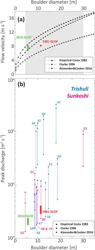
772 M. L. Huber et al.: Timing of exotic, far-traveled boulder emplacement and paleo-outburst flooding
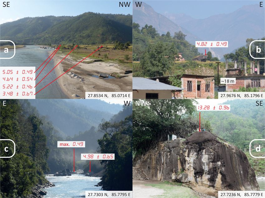
Figure 1. (a) Regional overview of the study area (red box). (b) Location of the studied river reaches in central Nepal (main catchments
of Trishuli and Sunkoshi, as well as the Sunkoshi subcatchment of Balephi), boulder locations studied and hydrological stations from the
Nepal Department of Hydrology and Meteorology (along with station number). Also shown is the trace of the Main Frontal Thrust (MCT;
see references in text), glacier cover (Global Land Ice Measurements from Space; GLIMS and NSIDC, 2005, updated March 2018) and an
estimate of maximum Quaternary glacial extent in the Langtang valley through evidence of valley morphology (Shiraiwa and Watanabe,
1991). The shaded relief is based on digital elevation model AW3D30, © Japan Aerospace Exploration Agency.
ning, 1891) was then used to estimate peak discharge from sample mass at each step (Lupker et al., 2012). Pure quartz
the peak flow velocity determined above and the valley cross- was dissolved after the addition of ca. 250 µg of 9 Be car-
sectional geometry using the numerical optimization scheme rier solution, and Be was isolated using sequential ion ex-
of Rosenwinkel et al. (2017). Peak discharges and maximum change column chromatography. The 10 Be concentrations
flood heights were calculated from flow velocities using the were measured for each sample at the Laboratory of Ion
average of two valley cross sections and bed slope for each Beam Physics of ETH Zurich using the 0.5 MV TANDY
boulder considered (Sect. S2). Access to MATLAB scripts AMS facility (Christl et al., 2013). Cosmogenic exposure
used for these calculations are detailed in the code availabil- ages were computed from the blank-corrected 10 Be/9 Be ra-
ity section below. tios using the online Cosmic Ray Exposure program (CREp)
calculator (http://crep.crpg.cnrs-nancy.fr, last access: 7 June
2018; Martin et al., 2017) and a global production rate 4.08±
3.3 Surface exposure dating 0.23 (atoms) g−1 yr−1 , the ERA40 standard atmosphere and
The samples for Beryllium-10 (10 Be) exposure dating were a correction for geomagnetic dipole moment changes. See
prepared in the laboratories of the Geological Institute in Supplement (Sect. S3) for more detailed information on sam-
the Earth Science Department at ETH Zurich. Bedrock was ple preparation and exposure age calculation.
crushed and sieved to 250–1000 µm. Quartz was isolated
by magnetic separation followed by five to seven sequen-
tial leaching steps with H2 SiF6 and HCl (two-thirds to one-
third by volume). Meteoric beryllium (Be) was removed by
three additional leachings with HF to dissolve ∼ 10 % of the
Earth Surf. Dynam., 8, 769–787, 2020 https://doi.org/10.5194/esurf-8-769-2020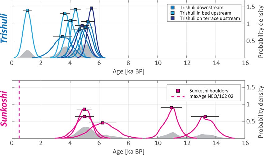
M. L. Huber et al.: Timing of exotic, far-traveled boulder emplacement and paleo-outburst flooding                                                                        773

Table 1. Summary table of boulder location, lithology, minimum travel distance and exposure age. Further details can be found in the
Supplement (Sects. S1 and S3).

  Sample number        Catchment                 Lat. (◦ )    Lon. (◦ )         Alt.         Boulder      Lithology                     Age (ka)   1σ (ka)        Minimum
                                                                           (m a.s.l.)   intermediate                                                                   travel
                                                                                        diameter (m)                                                         distance (km)∗
  NEQ/161 01           Sunkoshi                27.72911      85.77910           674               8.7     Orthogneiss                       4.98     0.65                 17
  NEQ/161 02           Sunkoshi                27.72805      85.77883           672               4.5     Whitish orthogneiss          max. 0.49                          17
  NEQ/161 03           Sunkoshi                27.72371      85.77810           668              29.9     Orthogneiss, augen gneiss,      13.28      0.96                 13
                                                                                                          Ulleri gneiss
  NEQ/162 44           Trishuli                27.85610      85.06961           441               9.2     Orthogneiss                      3.48      0.67            46 (13)
  NEQ/162 45           Trishuli                27.85601      85.06905           440               9.9     Orthogneiss                      5.22      0.46            46 (13)
  NEQ/162 46           Trishuli                27.85551      85.06886           445              12.5     Orthogneiss                      4.64      0.54            46 (13)
  NEQ/162 47           Trishuli                27.85589      85.06848           445                18     Phyllitic schist                 5.05      0.49            46 (13)
  NEQ/162 58           Trishuli                28.00898      85.18383           679              13.4     Phyllite                         3.63      0.35                  0
  NEQ/162 59           Trishuli                28.00888      85.18438           680               8.5     Orthogneiss                      1.06      0.29                 22
  NEQ/162 60           Trishuli                27.96964      85.18269           593              18.6     Schist                           4.35      0.37                  0
  NEQ/162 61           Trishuli                27.96942      85.18208           593              14.7     Schist                           4.01      0.43                  0
  NEQ/162 66           Trishuli                27.97021      85.17987           613               8.8     Schist                           4.82      0.49                  0
  NEQ/162 67           Trishuli                27.97065      85.17986           613               9.9     Phyllitic schist                 5.46      0.38                  0
  NEQ/162 79           Sunkoshi, Balephi       27.73503      85.78021           680               9.5     Orthogneiss, augen gneiss        6.23      0.92                 16
  NEQ/162 80           Sunkoshi                27.73389      85.78328           695              11.4     Orthogneiss, augen gneiss       10.96      0.73                 12
  NEQ/162 98           Sunkoshi, Balephi       27.74063      85.77722           693               9.4     Orthogneiss, augen gneiss        4.97      0.51                 11

∗ In brackets if drainage from eastern, non-glaciated and smaller tributaries is included (i.e., shortest distance to MCT).

Figure 2. (a) Boulders lying on a tributary fan south of Devighat, Trishuli valley. The main valley widens substantially at this location.
Sample from top to bottom (as shown in the figure): NEQ/162 47, 46, 45 and 44. (b) Boulder appears subangular sitting on top of terrace
deposit at Betrawati (NEQ/162 66), Trishuli valley. In the background, peaks rise more than 5000 m. (c) Narrow part of Sunkoshi River after
its confluence with Balephi Khola. Sample from top to bottom (as shown in the figure): NEQ/161 02 and 01. (d) Largest boulder surveyed
in this study (NEQ/161 03) in Sunkoshi valley with an intermediate diameter of 29.9 m consists of gneiss lithology (Ulleri gneiss) and has a
minimum travel distance of 13 km. The 10 Be surface exposure ages (in ka). Coordinates of viewpoints are given.

https://doi.org/10.5194/esurf-8-769-2020                                                                                      Earth Surf. Dynam., 8, 769–787, 2020
774                     M. L. Huber et al.: Timing of exotic, far-traveled boulder emplacement and paleo-outburst flooding

4     Results                                                     S2-3). Flow velocities calculated using a fluid density of
                                                                  1500 kg m−3 range between 6.7 and 17.3 m s−1 using the
4.1    Field survey and boulder lithology                         Clarke (1996) method and between 4.3 and 11.2 m s−1 us-
                                                                  ing that of Alexander and Cooker (2016) (Sect. S2, Table
We surveyed and sampled a total of 16 boulders: 10 boul-          S2-3). The approaches of Costa (1983) and Clarke (1996)
ders in the Trishuli River valley and 6 in the Sunkoshi River     produce similar results, while the method of Alexander and
valley (Figs. 1 and 3; Table 1). Along the Trishuli, the sam-     Cooker (2016) yields values less than an order of magni-
pled boulders are found in different locations and configura-     tude lower (Fig. 3). Paleo-discharge derived from these ve-
tions and have intermediate diameters ranging between 8.5 to      locities are shown in Fig. 3 (Sect S2, Table S2-3). Peak
18.6 m. Detailed descriptions of the boulders are in Sect. S1.    discharge values derived from Costa (1983), Clarke (1996),
In the upstream part of the studied reach, near the village of    and Alexander and Cooker (2016) range from 3.63 × 10³ to
Betrawati (27.974◦ N, 85.184◦ E), boulders are located both       1.97 × 10⁵ m3 s−1 for boulders in the Trishuli and 1.34 × 10³
in the modern floodplain close to the channel and on top of       to 1.03 × 10⁵ m3 s−1 for the boulders in the Sunkoshi.
terrace deposits ca. 18 m above the present-day channel el-
evation. Additional boulders ca. 15 km farther downstream
close to the village of Devighat (27.859◦ N, 85.109◦ E) are       4.3    Boulder exposure ages
deposited at the margin and close to the present-day channel      The 10 Be cosmogenic exposure ages of boulders in the Tr-
on a tributary fan. A total of 4 of the 10 boulders in the Tr-    ishuli valley have ages ranging between 2.81 and 5.84 ka
ishuli valley consist of gneiss, most likely orthogneiss origi-   (Fig. 4; Table 1) with overall 1σ uncertainties ranging from
nating from an intrusive protolith. Three gneiss boulders are     0.35 to 0.67 ka and the mode of the summed probability den-
located downstream of Devighat on a tributary fan, and one        sity functions around 4.5 ka. A total of 1 out of the 10 boul-
gneiss boulder is found north of Betrawati (Fig. 2, Table 1).     ders sampled upstream of Betrawati (NEQ/162 59; Fig. 4;
In both locations, the surrounding hillslopes are composed        Table 1; Sect. S3, Table S3-1) shows a significantly younger
of metasedimentary rocks of clearly differing fabric, so it is    exposure age of 1.06 ± 0.29 ka. This outlier concentration
unlikely that these boulders are locally derived. The other       probably reflects the effects of erosion or more likely burial
boulders surveyed in the Trishuli valley are bluish or green-     of the sampled flat top surface in the terrace deposit during a
ish phyllitic schists with a high phyllosilicate content with     more recent stage in time and thus may not represent the true
slightly differing fabrics among samples (Fig. 2; Table 1).       emplacement age.
These boulders have a lithology compatible with the bedrock          The Sunkoshi exposure ages can be assigned to three dif-
in the adjacent hillslopes but also areas farther upstream.       ferent age groups (Fig. 4). For one boulder with the small-
   Along the Sunkoshi, all the studied and sampled boul-          est intermediate diameter in this study of 4.5 m (NEQ/161
ders were found within ca. 3 km of the town of Balephi            02), the low 10 Be concentration only allows us to deter-
(27.732◦ N, 85.780◦ E) and downstream along the Sunkoshi.         mine a maximum age of 0.49 ka (Figs. 2 and 4; Table 1;
The six studied boulders have intermediate diameters ranging      Sect. S3, Table S3-1), which could indicate recent move-
from 4.5 to 29.9 m (Fig. 2; Table 1). Only one boulder sam-       ment (emplacement or toppling from an adjacent terrace de-
pled and surveyed was not exposed in the river channel but        posit). The next three older boulders (NEQ/161 01, NEQ/162
was embedded in a terrace deposit just upstream of Balephi        98 and NEQ/162 79) show consistent ages within 1σ un-
Khola’s confluence with the Sunkoshi main trunk (Fig. 2).         certainty with 4.98 ± 0.65, 4.97 ± 0.51 and 6.23 ± 0.92 ka
The lithology of these Sunkoshi boulders consists of a vari-      (Figs. 2 and 4; Table 1; Sect. S3, Table S3-1). Two older boul-
ety of gneisses (Fig. 2; Table 1); some show big porphyritic      ders are located in the Sunkoshi main channel with exposure
feldspar laths deformed to augen structures (NEQ/162 79, 80       ages of 10.96 ± 0.73 and 13.28 ± 0.96 ka (NEQ/162 80 and
and 98). Boulder sample NEQ/162 03, the largest boulder           NEQ/162 03, respectively) (Figs. 2 and 4; Table 1; Sect. S3,
surveyed in this study, has an augen fabric that looks more       Table S3-1).
homogenous and slightly less deformed than the other sam-
ples (Fig. 2; Table 1). The lithology of all boulders sampled
in the Sunkoshi is different from the schists found in bedrock    5     Discussion
on the adjacent hillslopes, and they are thus not locally de-
rived but allochthonous.                                          5.1    Boulder provenances and travel distances

                                                                  The schist and phyllite boulder lithologies in the Trishuli val-
4.2    Paleo-hydrologic discharge estimation                      ley are associated with the Paleoproterozoic lower Nuwakot
                                                                  group of the Lesser Himalayan sequence and more precisely
The average flow velocity values calculated based on the          are from the Kuncha Formation or the overlying Dandagaon
empirical approach of Costa (1983) are only dependent on          phyllites that could be found locally in the valley (Stöcklin,
the intermediate boulder diameter and range between 7.8           1980; Upreti, 1999). The Trishuli phyllite and schist boulders
and 16.7 m s−1 for the surveyed boulders (Sect. S2, Table         might, therefore, originate from adjacent hillslopes. How-

Earth Surf. Dynam., 8, 769–787, 2020                                                 https://doi.org/10.5194/esurf-8-769-2020
M. L. Huber et al.: Timing of exotic, far-traveled boulder emplacement and paleo-outburst flooding 775 Figure 3. (a) Theoretical flow velocities required to move boulders of a given diameter with explanatory input parameters (channel bed slope 0.03, rock material density 2700 kg m−3 , fluid density 1500 kg m−3 ) according to the parameterizations and models of Costa (1983), Clarke (1996), and Alexander and Cooker (2016). The gray shaded area indicates the range of boulder intermediate diameters from this study. Green and red rectangles are bounded by velocity estimates upstream and downstream of boulders (5.7 and 11.3 m in diameter) mobilized during the 2016 and 1981 GLOF events in the upper Sunkoshi (Cook et al., 2018; Xu, 1988). The Clarke (1996) method is plotted with a channel bed slope adjusted to Cook et al. (2018) which is the gradient of the Sunkoshi reach at the location of boulder movement (0.0245). (b) Estimated peak paleo-discharges required to move the studied boulders according to the three models that were used for paleo-discharge calculations. Green and red rectangles are bounded by upstream and downstream estimates of observed boulder movements for the 2016 and 1981 GLOF events in the upper Sunkoshi (Cook et al., 2018; Xu, 1988). https://doi.org/10.5194/esurf-8-769-2020 Earth Surf. Dynam., 8, 769–787, 2020
776                       M. L. Huber et al.: Timing of exotic, far-traveled boulder emplacement and paleo-outburst flooding

                                                                       an abundance of boulders present in the bed of the Balephi
                                                                       Khola.
                                                                          As noted above, boulders in both valleys are well below
                                                                       the extent of alpine glaciers in the modern period or during
                                                                       the last and previous glacial maximum stages and their asso-
                                                                       ciated glacial deposits (e.g., Shiraiwa and Watanabe, 1991;
                                                                       Owen and Benn, 2005; Owen and Dorch, 2014; Owen, 2020;
                                                                       Figs. 1 and 2). The low elevations where the exotic boul-
                                                                       ders are presently observed exclude a glacial transport mech-
                                                                       anism. Rather, the observed locations and our provenance
                                                                       analysis indicate that the mobilization and transport of large
                                                                       grain sizes occurred in central Himalayan river valleys over
                                                                       long distances (> 10 km) most likely through fluvial pro-
Figure 4. Probability density function for the 10 Be boulder ex-
                                                                       cesses.
posure ages in the Trishuli and Sunkoshi River reaches. The Tr-
ishuli boulders were subdivided in groups depending on boulder
geographical location (upstream vs. downstream) and position rel-      5.2   Paleo-discharge estimates
ative to the present-day channel. The gray shaded area in the back-
ground of each plot shows the cumulative sum of the probability        The range of discharge estimates derived in this work is a
distributions normalized by the quantity of boulders measured in the   first-order estimate and carries important assumptions. The
respective valley. Ages are indicated with 1σ error bars and were      sediment concentration of the flow directly influences trans-
calculated using the online CREp calculator (Martin et al., 2017)      port capacity through flow density and flow mechanics (e.g.,
accessed in June 2018 with a sea level high latitude production rate   Pierson and Costa, 1987). In hyperconcentrated flows with
of 4.08 ± 0.23 (atoms) g−1 yr−1 .                                      40 wt % to 70 wt % sediment entrainment, non-Newtonian
                                                                       plastic fluid behavior and laminar flow can arise due to the
                                                                       establishment of shear strength in the fluid material (e.g.,
ever, similar to the gneiss boulders, they are, in most cases,         Pierson and Costa, 1987). However, if the amount of sed-
subangular to subrounded with crescentic abrasion marks                iment entrainment remains at the lower end of this hyper-
suggesting substantial fluvial transport distances (Sect. S1).         concentrated range, flow mechanics are still adequately ap-
Diagnostic mineralogy and fabric of the other surveyed or-             proximated by Newtonian turbulent flow of a “clear” water
thogneiss boulders in the Trishuli catchment are not present           flood (Costa, 1984; Pierson and Costa, 1987; Pierson, 2005;
in the Lesser Himalayan sequence and, therefore, must origi-           Wang et al., 2009; Hungr et al., 2014), as was assumed here.
nate from areas upstream (or structurally above) of the MCT            Nevertheless, our calculations do not apply to higher sedi-
(Fig. 1). No known higher Himalayan unit klippe is mapped              ment load conditions like, for example, conditions associated
on hillslopes directly above the studied reaches, and the              with debris flows. Other uncertainty arises from the extrac-
mixed boulder lithologies make a local emplacement source              tion of valley cross-sectional profiles using topographic maps
through mass-wasting unlikely. These observations, there-              (see Sect. S2 for more details). Terrace flats and channel
fore, require minimum transport distances of approximately             widths are only crudely represented and do not account for
22 to 46 km depending on the present boulder location (Ta-             past channel morphologies before and during the time of the
ble 1).                                                                floods. Since detailed riverbed morphology is required for the
   A variety of gneiss boulder lithologies are found in the            hydraulic discharge calculation, additional uncertainty arises
Sunkoshi/Balephi Khola catchment. Orthogneiss and augen-               from the resolution of the data used here and the necessity
gneiss lithologies among boulders around Balephi are of                of using the modern channel geometry for these calculations.
higher metamorphic grade (amphibolite to granulite facies)             We hypothesize that these uncertainties are the main reason
and must originate upstream to the north across the MCT                for the discrepancies between peak paleo-discharge estimates
from higher Himalayan crystalline rocks present in these               for boulders from a similar age range that were presumably
areas or from gneiss to be found just below the MCT in                 moved during a single event (Fig. 3). First-order discharge
the Lesser Himalayan footwall (Ulleri-type augen gneiss                estimates for boulder transport of surveyed clast sizes, there-
for NEQ/162 03; see Sect. S1) (Shrestha et al., 1986; Am-              fore, broadly range from ca. 103 to 105 m3 s−1 .
atya and Jnawali, 1994; Dhital, 2015). In the absence of                  These estimates are corroborated by observed boulder
known higher Himalayan units directly upslope above this               movement under known discharges (Fig. 3a) reported in
reach of the Sunkoshi, this analysis suggests minimum                  Xu (1988) and Cook et al. (2018) in the upper Sunkoshi
transport distances of ca. 11 to 17 km (Fig. 1; Table 1).              (some 30 km upstream of Balephi). During the 2016 GLOF
While the surveyed boulders are mostly located below the               event, Cook et al. (2018) report the movement of a ca. 5.7 m
Sunkoshi/Balephi Khola confluence and could, therefore,                diameter boulder for mean flow velocities between 8.2 and
have been transported by both rivers, field observations show          6.8 m s−1 . An earlier study also reported the movement of a

Earth Surf. Dynam., 8, 769–787, 2020                                                     https://doi.org/10.5194/esurf-8-769-2020
M. L. Huber et al.: Timing of exotic, far-traveled boulder emplacement and paleo-outburst flooding 777 boulder of ca. 11.3 m in intermediate diameter for water flow the hydrological stations shows that flows needed to mobi- velocities between 8.4 and 8.0 m s−1 during the 1981 GLOF lize the studied boulders generally exceed the largest flows in the same reach (Xu, 1988). Velocity and discharge esti- on record (Figs. 3 and 5). Discharge records may also in- mates broadly agree with our estimates derived from the re- clude LOF events and, therefore, not only reflect monsoonal- lations for boulder incipient motion of Costa (1983), Clarke precipitation-driven discharge. This finding suggests that (1996), and Alexander and Cooker (2016). It is important to typical monsoonal floods are unlikely to have the ability to mention that peak discharges cannot be directly compared move boulders of exceptionally large size (> 10 m) and that because of the various distances to potential source areas. LOFs are the most likely events responsible for large boul- To place our results in the context of previous studies, we der displacement. The reconstruction of flood duration or ini- compare our discharge to those from the literature and histor- tial lake size is, however, hampered by the multiple possible ical records. Cenderelli and Wohl (2001) compared seasonal lake locations, unknown breach mechanisms and the large high flow floods (SHFFs) with discharges of recent GLOF uncertainties of our paleo-flood discharge estimates. Such a events, and they appeared to be at least 1 order of magnitude reconstruction is beyond the scope of this work and would higher than monsoonal precipitation peak discharges in the require dedicated and computationally expensive fluid flow central Himalayan Mount Everest region for reaches span- numerical models (e.g., Carling et al., 2010; Denlinger and ning many tens of kilometers downstream of the breach lo- O’Connell, 2010; Turzewski et al., 2019). cations. Peak discharges reaching 105 m3 s−1 substantial dis- tances downstream have been documented or suggested for 5.3 Timing and boulder emplacement mechanisms a few historical events in the Himalayas mainly associated with LLOFs such as the great Indus flood of 1841 (Mason, The boulder population in the Trishuli valley displays a broad 1929; Shroder et al., 1991), the great outburst in April 2000 range of exposure ages from ca. 3 to 6 ka with the notable in the Tibetan Yigong Zangbo River (Shang et al., 2003; De- exception of NEQ/162 59 which is significantly younger at laney and Evans, 2015; Turzewski et al., 2019) and the large ca. 1 ka (Fig. 4). The NEQ/162 59 boulder is still buried to LLOFs at Dadu River and Yalong River in the years 1786 a large extent, and its flat surface is only slightly elevated and 1967 in Sichuan province, China (Dai et al., 2005; Run- from the surrounding ground surface, suggesting that it was qiu, 2009). These events are, however, rarely observed even likely covered by sediment until recently. There is a system- though there is sedimentological evidence that large-scale atic offset in age (up to 2 kyr) between older exposure ages LLOF events happened regularly throughout the Holocene of boulders currently located on the fill terrace near the town within the same catchments (e.g., Hewitt et al., 2011; Wasson of Betrawati and younger boulder ages in the channel or fur- et al., 2013). To our knowledge, GLOF discharge estimates ther downstream in the wider valley reach (Fig. 4). In the of historically documented events in the Himalayas reach ca. Sunkoshi/Balephi Khola, three exposure age groups can be 104 m3 s−1 (e.g., Vuichard and Zimmermann, 1987; Hewitt, identified: (i) the youngest but also the smallest boulder sur- 1982; Xu, 1988; Yamada and Sharma, 1993; ICIMOD et al., veyed only yields a maximum age of ca. 500 yr given mea- 2011; Cook et al., 2018) with Holocene-reconstructed dis- surement uncertainties, (ii) a group of three boulders with charge estimates that exceed 105 m3 s−1 , such as that recon- exposure ages ranging from ca. 3.5 and 6.5 ka, and (iii) two structed by Montgomery et al. (2004) for the Tsangpo River late Pleistocene boulders, one of which is the largest sur- gorge outburst flood for locations more than 10 km down- veyed boulder in our dataset. Based on these exposure ages stream of the paleolake. and considerations presented in the previous sections, three Hydrological stations from the Department of Hydrology main scenarios can be proposed for the emplacement of the and Meteorology, government of Nepal, allow the compari- surveyed boulders: (1) repeated boulder transport events, (2) son of our paleo-discharge estimates to measured discharges excavation of boulders from large, older fill deposits, and (3) over the last decades. For the Trishuli reach, station num- catastrophic events that resulted in long-range fluvial trans- ber 447 (27.97◦ N, 85.18◦ E) near the town of Betrawati port of the boulders. These scenarios are further discussed in is located in between the two studied upstream and down- the following paragraphs. stream boulder fields (Fig. 1). For the Sunkoshi boulders, The slow transport of the boulders during repeated catas- two stations provide background hydrological information trophic events requires reoccurring exceptional discharges (Fig. 1). First, station number 620 (27.80◦ N, 85.77◦ E) is throughout the Holocene, as suggested by the flow veloci- on the Balephi Khola about 8 km upstream of the most up- ties that are required to mobilize these boulders. Such a sce- stream boulder and 9 km upstream from the confluence with nario is compatible with repeated GLOFs that frequently af- the Sunkoshi main stem (without any major tributary con- fect central Himalayan valleys (e.g., Veh et al., 2019). How- fluences). Second, station number 610 (27.79◦ N, 85.9◦ E) is ever, it is unlikely that such a mechanism is able to explain on the Sunkoshi at Bahrabise that is located about 14 km up- the distribution of exposure ages observed in this study. Re- stream of the Balephi Khola and Sunkoshi confluence. Com- peated transport episodes will displace and rotate boulders, parison of the estimated paleo-discharges, which range be- successively exposing different faces to dosing by cosmic tween ca. 103 to 105 m3 s−1 with flow duration curves of rays. In such a case, boulder exposure ages would show a https://doi.org/10.5194/esurf-8-769-2020 Earth Surf. Dynam., 8, 769–787, 2020
778                       M. L. Huber et al.: Timing of exotic, far-traveled boulder emplacement and paleo-outburst flooding

broad distribution of ages reflecting repeating episodes of          of boulders with the existence of at least one event in the
transport, stabilization and exposure. Therefore, the consis-        Trishuli and at least two events in the Sunkoshi/Balephi
tency of the age distributions makes it unlikely that the suite      Khola reaches. Such catastrophic events are also likely to in-
of sampled boulders was transported during multiple events.          duce downstream landsliding by undercutting channel banks
This interpretation is also supported by the observation of          (Cook et al., 2018) and hence to entrain boulders from dif-
similar age distributions for boulders in valleys separated by       ferent lithologies along its flow path while resulting in simi-
a main drainage divide; the clustering of boulder ages in ad-        lar exposure ages across lithologies once deposited. It would
jacent valleys hints at a process capable of affecting flood         also explain the observation in the Sunkoshi/Balephi Khola
distributions in two rivers around the same time. It should          reach that the smallest boulder has the youngest exposure age
also be noted that there is a likely upper limit to the survival     and the largest the oldest, which is consistent with the fact
duration of boulders in a fluvial channel as fluvial abrasion        that the boulders of older, larger events are not remobilized
and comminution processes during transport (Attal and Lavé,          by subsequent smaller ones (also suggesting that our dataset
2009; Carling and Fan, 2020) or while at rest in the channel         is likely biased towards large events as the smaller events are
bed (Shobe et al., 2016; Glade et al., 2019) will ultimately re-     likely erased). We, therefore, suggest that catastrophic long-
duce the size of the boulder until it can be exported by more        range transport and rapid emplacement are the most likely
frequent smaller flows.                                              scenario to explain our data.
    Large valley-fill deposits are frequently observed in Hi-           In the Trishuli reach, the timing of a single catastrophic
malayan valleys and span a wide range of ages (Lavé and              event is most accurately recorded by the ages of boulders
Avouac, 2001; Pratt-Sitaula et al., 2004; Stolle et al., 2017).      on top of the small fill terrace in the upstream reach, and
The evacuation and re-incision of such deposits could expose         the downstream boulders with a similar age (Fig. 4) as up-
boulders that were entrained and emplaced during the initial         stream boulders in the active channel have likely experienced
event and result in apparent exposure ages that are contem-          shielding by the terrace fill sediments, as discussed above.
poraneous to the incision of the fill instead of the boulder         This yields an emplacement age estimate for the Trishuli of
transport. Remnants of such large fill deposits are not visible      around 5.0 ± 0.3 ka (arithmetic mean with 1σ error of boul-
on the valley flanks in the direct vicinity of the studied lo-       der samples NEQ/162 45, 46, 47, 66 and 67; Table 1). In the
cations. A large (> 100 m thickness) presumably Pleistocene          Sunkoshi/Balephi Khola reach, the oldest event is recorded
fill terrace is nevertheless present farther downstream of the       by two boulders, NEQ/161 03 and NEQ/162 80, transported
upstream Trishuli boulder locations (27.888◦ N, 85.141◦ E)           during the same event or series of events (within dating un-
near the town of Trishuli Bazar (Lavé and Avouac, 2001).             certainty) that occurred at ∼ 11 to 13 ka (Fig. 4; Table 1). It
However, the highly weathered state of this fill deposit ma-         is followed by a second event recorded by the exposure age
terial suggests that large boulders would unlikely be pre-           of three boulders with ages that agree within dating uncer-
served intact in such a warm and humid climate. A fill de-           tainty of around 5.4 ± 0.7 ka (arithmetic mean with 1σ error
posit re-incision scenario would require these processes to          of boulder samples NEQ/161 01, 79 and 98; Table 1). Finally,
be synchronous across the drainage divide to explain the             a single boulder (NEQ/161 02; Table 1) only resulted in the
broadly similar age cluster at 5 ka observed in the Trishuli         determination of maximum exposure age based on the low
and Sunkoshi reaches. Re-incision would also need to oc-             10 Be concentration of ca. 0.5 ka. This is the smallest boulder

cur rapidly to explain the relatively narrow age distribution        surveyed and could have been mobilized during a smaller re-
of boulders sampled at different locations along the stream          cent LOF or alternatively could have toppled over or was af-
as slow excavation since the Pleistocene would result in a           fected by unrecognized large surface erosion, both of which
broad range of ages. While not impossible, this process is           would result in a younger exposure age.
more complex and nuanced than our preferred interpreta-                 The relatively large spread of exposure ages compared to
tion of mobilization and emplacement during a single large           other settings such as moraine boulders, for instance, can
flood event. However, as we noted earlier, the upstream Tr-          likely be attributed to the fluvial setting. Boulders can be af-
ishuli reach boulders in the active channel are systematically       fected by nuclide inheritance if surfaces were exposed for
younger (1–2 ka) compared to boulders located on the adja-           significant durations prior to entrainment, which would bias
cent terrace. We interpret these younger ages to be the result       the ages to be too old. Erosion of the boulder surface, a plau-
of the shielding of the boulders trapped in this thin fill deposit   sible process for boulders sitting in the channel of a moun-
(< 20 m thickness) before being exposed when the river re-           tainous stream, would bias the ages to be too young. But
incised the deposit (Figs. 2 and 4; Table 1; Sect. S1). This         only significant erosion, such as the fracturing of a sizable
re-incision, however, had to occur rapidly or the age differ-        part of the boulder surface (which was avoided for sam-
ence between in-channel and terrace-top would be larger.             pling if recognized in the field), would affect the exposure
    The third possible mechanism of emplacement is the               ages (a steady-state weathering of the boulder surface of
mobilization of these boulders by catastrophic high dis-             10 mm kyr−1 would reduce the exposure age of a 5 kyr old
charge events capable of mobilizing boulders over long dis-          boulder by ca. 150 yr). Partial cover by sediments is also a
tances. Such a scenario would explain the age distribution           plausible explanation for the scatter in exposure ages, and

Earth Surf. Dynam., 8, 769–787, 2020                                                    https://doi.org/10.5194/esurf-8-769-2020
M. L. Huber et al.: Timing of exotic, far-traveled boulder emplacement and paleo-outburst flooding 779
we invoke this effect for the younger ages of the boulders in
the channel of the upstream reach of the Trishuli or boulder
NEQ/162 59. However, since these processes (inheritance,
erosion and partial sediment cover) are stochastic, it would
be expected that if they dominated the signal, exposure age
distributions would be more widespread than what was ob-
served.
Trishuli and part of the Sunkoshi/Balephi Khola boulders
show a clustering around 5 ka across a major drainage di-
vide in the central Himalayas (Figs. 1 and 4). At least two
older ages in the Sunkoshi indicate flooding during the late
Pleistocene (Fig. 4); similar ages were not observed in the
Trishuli valley (Fig. 4). The events that emplaced these large-
sized boulders of ca. 10 m in diameter or more are rare since
they represent the remnants of the last largest floods that
were not remobilized by subsequent floods (Carling and Tin-
kler, 1998). The resolution of 10 Be exposure ages and uncer-
tainty on the state of dated boulder surfaces does not defi-
nitely point toward a single event that affected both catch- Figure 5. Flow frequency curves of daily discharge data from
ments. Boulder emplacement could potentially be the result the Trishuli at Betrawati (station no. 447), the Sunkoshi in Bahra-
of a series of events that occurred in a short time period bise (station no. 610) and the Balephi Khola in Jalbire (station no.
620) along with the period covered by the data and the number of
of a few hundred years within the range of dating uncer-
daily discharge measurements (data from the government of Nepal,
tainty (Fig. 4). However, the assumption that the boulder em- Department of Hydrology and Meteorology). The range of paleo-
placements only record a flood of maximum magnitude (see discharges required to mobilize the studied boulders is shown in
above), the rarity of emplacement and the absence of obvi- shades of gray. The discharge measured in Bahrabise for the 2016
ous stratification in the fill terraces (Fig. 2; Sect. S1, Fig. S1- GLOF on the Sunkoshi is also shown for comparison (Cook et al.,
3A) point toward synchronous middle Holocene emplace- 2018).
ment events in each valley.
The timing of the Trishuli and Sunkoshi/Balephi Khola
events found in this study is comparable to another large likely needed to explain the emplacement of large boul-
event responsible for the extensive fill terraces found in the ders in the Trishuli and Sunkoshi drainage catchments and
central Himalayan Marsyangdi river valley about 90 km to that these events were clustered in time around 5 ka in at
the west of the Trishuli valley (Pratt-Sitaula et al., 2004). least two distinct valleys (Figs. 3, 4 and 5). To attribute
The authors of that study found large terraces (middle ter- these events to LLOFs or GLOFs requires evaluating our
races) composed of heterolithic conglomerates and boulders data in light of typical earthquake recurrence times and re-
with lithologic evidence of transport distances of over 40 km. gional climate variability. Earthquakes and their associated
These fill terraces were interpreted as the result of a single coseismic landslides provide a mechanism that could syn-
massive earthquake-triggered landslide event that caused a chronously emplace large landslide dams in main valleys
catastrophic debris flow. Recalibrated radiocarbon ages of across water divides, exposing downstream reaches to LLOF
that infill date back to 4.6 to 5.1 ka (Yamanaka, 1982; ages events. Climate variability can directly affect precipitation
recalculated with OxCal online calibrator; Bronk Ramsay, patterns and intensity during the monsoon or indirectly affect
2013; Reimer et al., 2013). The ages determined for the Tr- glacial dynamics through its modulation of glacier extent and
ishuli and Sunkoshi/Balephi Khola boulders are, however, proglacial lake volumes. Climate can, therefore, also be in-
older compared to the exposure age of another large far- voked as a potential trigger of large LOF events in multiple
traveled boulder studied which caps the Pokhara formation valleys during a short period of time, as observed in our data.
further west in Nepal (ca. 1680 CE) (Fort, 1987; Schwang- The timing of the boulder emplacement in the Trishuli and
hart et al., 2016a). The emplacement of this later boulder Sunkoshi/Balephi Khola suggests that these high-magnitude
linked to a historical 1681 CE earthquake even though the flows last occurred ca. 5 kyr ago. Older, larger boulders in the
magnitude and epicenter of this later event remain poorly Sunkoshi/Balephi Khola suggest flows of even higher mag-
constrained (Chaulagain et al., 2018). nitude affecting trans-Himalayan valleys in the late Pleis-
tocene. While the dating precision available cannot strictly
5.4 Triggers of Holocene catastrophic LOFs
point towards a synchronous emplacement amongst the stud-
ied valleys (and the Marsyangdi valley; Pratt-Sitaula et al.,
Our results demonstrate that high-magnitude peak discharge 2004), major to great earthquakes (≥ Mw 7.0 and 8.0, re-
(103 to 105 m3 s−1 ) by lake outburst events (LOFs) are most spectively) periodically rupture large parts of the Main Hi-
https://doi.org/10.5194/esurf-8-769-2020 Earth Surf. Dynam., 8, 769–787, 2020780 M. L. Huber et al.: Timing of exotic, far-traveled boulder emplacement and paleo-outburst flooding malayan Thrust resulting in surface ground shaking over Tibetan plateau (Thompson et al., 1997) (Fig. 6). In response distances of hundreds of kilometers along the Himalayan to the decrease in monsoonal precipitation, a number of pre- range (e.g., Bilham, 2019). These earthquakes can trigger a served glacial landforms in the central Himalayas show a large surface response with intense coseismic landsliding, as phase of glacial retreat around 5 ka (Abramowski et al., 2003; was observed during the 2015 Mw 7.8 Gorkha earthquake Finkel et al., 2003; Gayer et al., 2006; Pratt-Sitaula et al., (Roback et al., 2018). Although the 2015 earthquake did not 2011; Fig. 6). This retreat has not been observed in all stud- result in significant valley blocking due to landsliding that ied valleys, but glacial moraines dated to around 5 ka are re- can result in large LLOFs, the total volume of coseismic ported in the Langtang valley (upstream Trishuli catchment) landsliding scales with earthquake magnitude (Marc et al., and in the Manaslu massif (Machakhola) by Abramowski et 2016), and hence LLOFs might more likely follow earth- al. (2003) (10 Be ages) and in the Khumbu Himal (Everest re- quakes with magnitudes larger than Gorkha. Great earth- gion) with the Thuklha stage by Finkel et al. (2003) (10 Be quakes (≥ Mw 8.0) in the Himalayas able to trigger large ages), as well as 3 He and 10 Be ages derived by Gayer et volumes of landsliding beyond what was observed during al. (2006) for moraines in the upper Mailun valley (Trishuli Gorkha have estimated recurrence times of 750 to 1000 yr catchment). These studies suggest a regional glacial response (Bollinger et al., 2014; Sapkota et al., 2013). If great earth- to aridification (Fig. 6). Although the relation between GLOF quakes had a large likelihood to trigger widespread LLOFs frequency and ongoing climate change remains unclear (Har- (as would be required to explain the emplacement of boul- rison et al., 2018; Veh et al., 2019), past large phases of ders and valley fills in two to three valleys), we would expect glacier retreat have been suggested to increase GLOF fre- the central Himalayan valleys to be strewn with boulders of quency (e.g., Walder and Costa, 1996; Clague and Evans, younger and possibly more diverse ages owing to the geo- 2000; Wohl, 2013). Moraine dams form especially if fast logically frequent recurrence interval of such events. Larger glacial retreat follows earlier advances (Korup and Tweed, events, such as the possibility for earthquakes greater than 2007). The documented phase of glacial retreat at ca. 5 ka, Mw 9.0 with a suggested recurrence interval of more than therefore, represents a possible triggering mechanism for the 800 yr along the entire Himalayan arc (Stevens and Avouac, emplacement of the studied boulders across river drainage di- 2016), could also trigger rare and large LLOFs. However, vides as it may have resulted in the more wide-spread occur- large hillslope failures and valley fills have been shown to oc- rence of glacier lakes prone to GLOFs. Climatic forcing of cur for lower earthquake magnitudes as well (e.g., Schwang- GLOFs is, therefore, a suitable explanation for the emplace- hart et al., 2016a), and other controls on landslide initiation ment of far-traveled fills in other valleys in the central Hi- are likely important factors as well, e.g., hillslope saturation malayas (e.g., Pratt-Sitaula et al., 2004) and agrees with the (Lu and Godt, 2013). We, therefore, consider it unlikely that provenance of a number of gneiss boulders originating from LLOFs are restricted to large (≥ Mw 9.0) events. Further- the glaciated higher Himalayan crystalline. It should also be more, the likelihood of an earthquake triggering LLOFs in noted that abrupt climatic shifts such as the one following the two to three valleys during the same event is small. While EHCO, occurred overall less frequently since the last glacial earthquake-triggered LLOFs cannot be excluded (and have maximum (LGM) compared to the recurrence time of great been proposed for other catastrophic valley fills; Schwang- earthquakes. hart et al., 2016a), we do not favor this explanation for the The older exposure ages derived in the Sunkoshi catch- emplacement of the boulders that are the focus of this inves- ment, including the largest boulder surveyed in this study tigation. (NEQ/161 03 with 29.9 m intermediate diameter; Figs. 2 and Climate change may be another LOF trigger. Given the 4; Table 1), could be attributed to an LGM or post-LGM large size of the studied catchments, as well as the modern glacial retreat that led to events being preserved in the chan- discharge record (Fig. 5), it is unlikely that exceptional and nel till today (see Schaefer et al., 2008; Fig. 6). If correct, our localized extreme rainfall could occur synchronously in two dataset reflects that long-term climate-modulated LOFs can large valleys. However, climate, through its modulation of alter Himalayan valleys on 103 to 104 yr timescales. glacier dynamics and the creation of proglacial lakes, could control the occurrence of GLOFs. Multiple terrestrial records 5.5 Implications for erosion and geohazards in the for the monsoon-influenced Himalayas and the Indian sub- Himalayas continent indicate a wet and strong monsoon phase during the Early Holocene Climatic Optimum (EHCO), followed by This study found evidence for high-magnitude discharge a dry phase between 5 and 4 ka. This dry phase is recorded events in the form of outburst flooding in central Himalayan amongst other proxy records by a compilation of Indian mon- river valleys. A record of exceptional flooding is preserved soon records (Herzschuh, 2006), the transition to more arid not only in the form of large boulders but also in the form of conditions in central India that led to a vegetation transition large alluvial fills in Himalayan valleys (Lavé and Avouac, towards C4 grasses as recorded in the Lonar Lake crater sed- 2001; Pratt-Sitaula et al., 2004; Stolle et al., 2017). As men- iments (Sarkar et al., 2015), and changes in moisture sources tioned before (Wohl, 2013; Cook et al., 2018), LOFs may as indicated by a drop in δ 18 O of the Guliya ice cap on the be responsible for channel incision and lateral erosion in Earth Surf. Dynam., 8, 769–787, 2020 https://doi.org/10.5194/esurf-8-769-2020
You can also read