East Africa Flood Scenarios 2020 - World Food Programme, Climate and Earth ObservationTeam Research Assessment and Monitoring Division - WFP
←
→
Page content transcription
If your browser does not render page correctly, please read the page content below
East Africa Flood Scenarios 2020

World Food Programme,
Climate and Earth ObservationTeam
Research Assessment and Monitoring Division   20 May 2020   1
SUMMARY

 •   After a drier than average period across East Africa until mid 2019, conditions turned sharply to much wetter
     than average weather. Across vast areas of the region, the last nine months have been the wettest ever in the
     near 40 year data record. The most affected areas include the South Sudan – Ethiopia borders, Lake Victoria
     and western-central Kenya and SE Ethiopia and northern Somalia.
 •   Sustained, extreme rains have resulted in floods and landslides across Kenya and Uganda since mid 2019 to
     now and additional flooding in SE Ethiopia and Somalia both during the Short Rains of late 2019 and the
     current Long Rains season. In South Sudan, huge increases in wetland extent led to localised famine events
     while flooding of dry season pastures led to massive inter-communal fighting that is still on-going. In Uganda,
     Lake Victoria hit record height levels leading to floods and destruction of livelihood infra-structures.
 •   Latest seasonal forecasts from a wide variety of sources unanimously indicate a continuation of much wetter
     than average conditions until September 2020, in particular for a region extending from NW Kenya to western
     Ethiopia and eastern South Sudan.
 •   Expected consequences include: a continuation of flooding and landslides in western Kenya and Karamoja;
     additional flooding in eastern South Sudan, possibly leading to acute food insecurity and further inter-
     communal fighting later in the year; heavy rains along the Blue Nile catchment and increased White Nile flows
     may lead to flooding along both rivers within Sudan.

                                                                                                                       2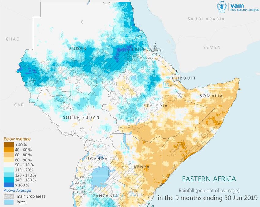
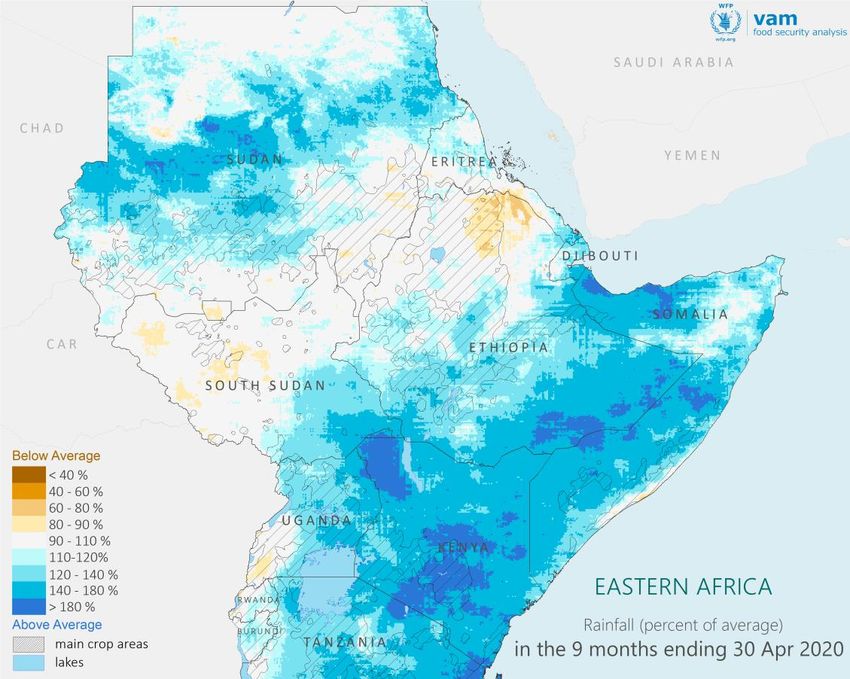
Context: Regional Rainfall 2019-2020

Rainfall in the 9 months ending in June 2019 (left) and 9 months ending in April 2020 (right) as a percent of the long term average. Blues for wetter than average, browns for drier than average.

 Floods follow Drought across East Africa
 A long drier than average period affected East Africa during the Short Rains of late 2018 and the Long Rains of 2019 (March to May). From mid-2019
 however, conditions changed sharply bringing much wetter than average weather across the region. These conditions have remained in place since
 then, with the sustained heavy rains leading to flooding events across the region during the Short Rains of late 2019 and the Long Rains of March to
 May of 2020.
                                                                                                                                                                                                     3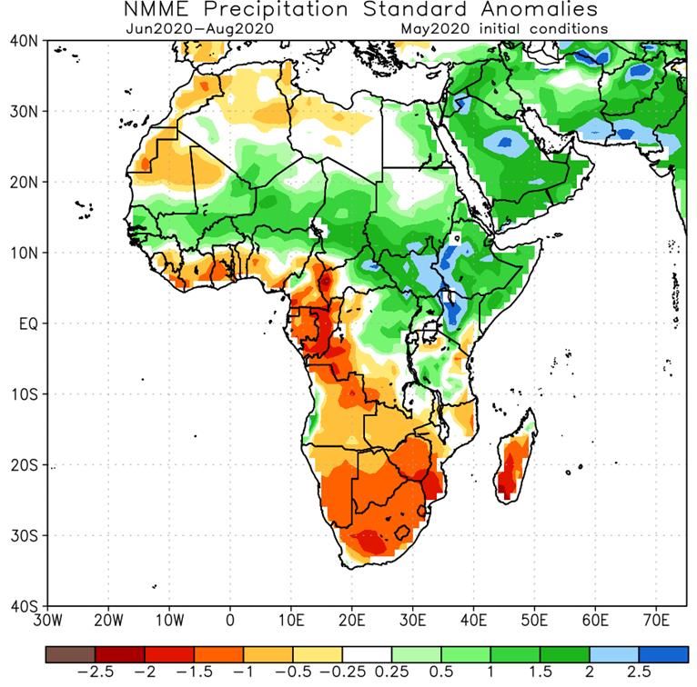
Context: Rainfall Extremes 2019-2020
                                                                                                          Widespread Extreme Rainfall 2019-2020
                                                                                                          The East Africa region is undergoing an extremely wetter than
                                                                                                          average period across most of the region. To map the intensity and
                                                                                                          spatial extent of possible extremes, recent rainfall data was
                                                                                                          expressed as ranks within the nearly 40 year CHIRPS rainfall archive.
                                                                                                          The results for a 9 month rainfall total ending in April 2020 are
                                                                                                          shown in the map. This 9 month period includes the current Long
                                                                                                          Rains, the previous Short rains (late 2019) and the late stages of the
                                                                                                          main season in the Sudans and Ethiopia.
                                                                                                          Areas in darkest blue show where this 9 month rainfall was the
                                                                                                          highest ever since 1981. Areas with second and third highest rainfall
                                                                                                          are also shown as lighter blues. The huge extent of the wettest-ever
                                                                                                          areas is unprecedented.
                                                                                                          Several areas of extreme rainfall with different timings are: around
                                                                                                          Lake Victoria and western-central Kenya which is still on-going; the
                                                                                                          border between South Sudan and Ethiopia which eased off in late
                                                                                                          2019; SE Ethiopia and northern Somalia, during the recent season
                                                                                                          (March-April).
                                                                                                          These resulted in floods and landslides across Kenya and Uganda
                                                                                                          during this whole period, in eastern South Sudan and in Somalia
                                                                                                          along rivers swollen by heavy rains in SE Ethiopia. Displacement in
                                                                                                          Kenya and heavy armed conflict in Jonglei, South Sudan were the
                                                                                                          most evident consequences.
Rainfall amounts from August 2019 to April 2020 expressed as ranks in the historical record since 1981.
Wet extremes in shades of blue, Dry extremes in shades of red.
                                                                                                                                                                                   4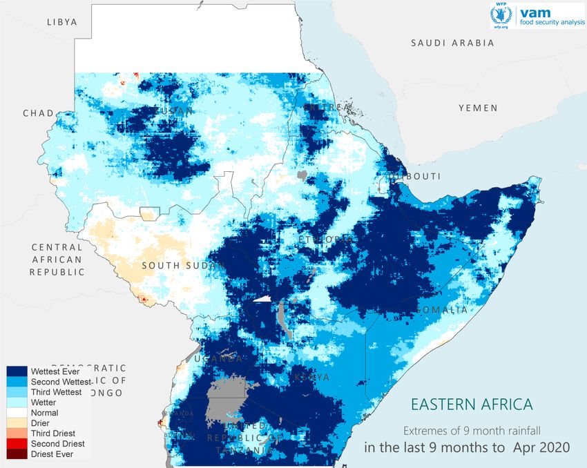
Context: River Basins
Lake Victoria Rainfall
The 39 year record for Lake
Victoria catchment rainfall was
broken twice in succession in
2018 and 2019. Most of the
rainfall behind the 2019 record
fell in the second half of the year.
Rainfall in 2020 is already above
the long term average by 16%. Annual rainfall over the Lake Victoria catchment from 1981 to 2019
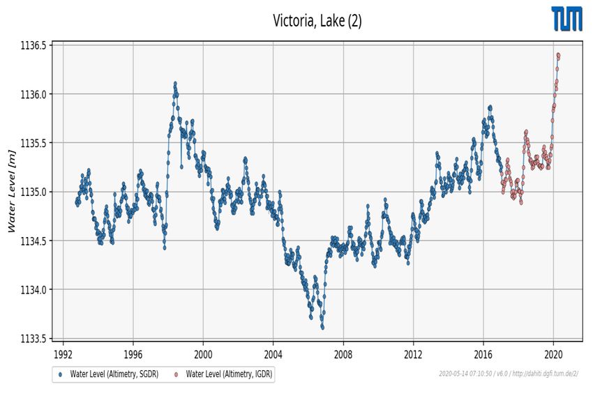
Altitude of Lake Victoria surface since 1992 to present day from altimetry measurements
Lake Levels
The sustained high rainfall in the Lake Victoria catchment for the past
two years is likely the main driver behind the recent and sharp rise in
the levels of the Lake since late 2019 – these are heading to 3m above
the minimum of 2007 and well above the peak reached during the
strong El Nino of 1997. This has led to flooding in coastal lake areas,
damage to infra-structure and potentially may damage energy supply.
Besides these immediate effects, high lake levels will lead to slow
changes in the extent of the huge wetland systems of South Sudan,
influencing the local dynamics of natural and livelihood resources in
complex ways.
5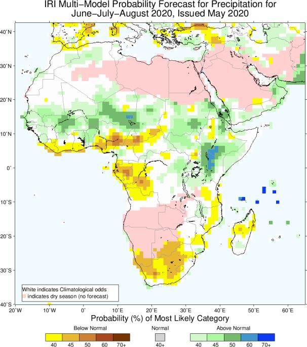
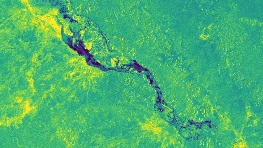
Context: River Basins
                                                                        Record Wetland Extent in South Sudan: late 2019 – early 2020
Floods, Famine and Conflict in South Sudan 2019
Heavy rains affected South Sudan and neighbouring regions in
2019, in particular within the Pibor-Akobo-Sobat catchment, which
drains into the states of Jonglei and Upper Nile. Record rains within
the catchment led to extensive flooding in Jonglei state that were
the driver for localised famine conditions in late 2019.
By early 2020, wetlands within Jonglei had reached an
unprecedented extent, destroying dry season pastures and leading
to large scale communal fighting which at some stage involved
close to 8,000 combatants. Retaliation attacks have continued until
very recently.

Record Rains Elsewhere
Other catchments of the wider Nile River basin have also been
registering record rainfalls.
                                                                         Wetland extent in South Sudan in late 2019-early 2020 following
Rainfall in 2019 was a record for the basin of Lake Albert - Lake        record rains in the Pibor-Akobo-Sobat river basin.
Kyoga, in the vicinity of Lake Victoria.                                 Note the huge extent of “new” wetland within Jonglei State,
                                                                         within the red circle. Flooding of dry season pastures led to
The huge Blue Nile catchment (mostly in Ethiopia) also registered        intense large scale inter-communal fighting.
record rainfall in 2019 with 2017 a close second.

                                                                                                                                           6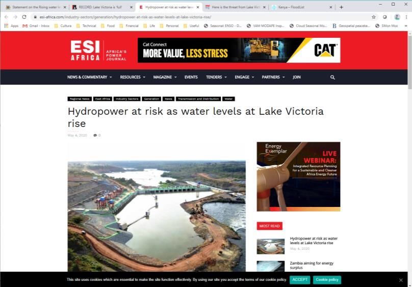
Outlook: Seasonal Forecasts

                                                                                                          Area of
                                                                                                          Likely
                                                                                                          Extreme
                                                                                                          Rainfall

                                                                                                                 Six-forecast consensus published by ECMWF. In red areas where June-
                                                                                                                 August rainfall is expected to fall in the top 20% of the historical record.

 Seasonal rainfall forecasts for June-August 2020: Left, from NCEP-CPC, Middle, from IRI.
 Greens and blues for wetter than average, reds and browns for drier than average

Forecasts Indicate Further Flooding is Likely                                                     Most of these regions are already suffering from the effects of extreme rains – given the
                                                                                                  unanimity in the seasonal forecasts, there is high confidence that further impacts are to
Seasonal forecasts from a wide variety of sources unanimously indicate much wetter                be expected.
than average conditions for the period from June to September 2020, in most of the
same areas that have been already affected by rainfall extremes since August 2019.                Besides a continuation of flooding and landslides in western Kenya and Karamoja, there
Some forecasts indicate a high probability of the rainfall in this period to fall in top 20% of   is a significant likelihood of additional flooding in eastern South Sudan – this may lead to
the historical record.                                                                            a repeat of localized famine events and renewed heavy inter-communal fighting as a
                                                                                                  result of flooding of pasture resources.
The area forecast to be most affected by these wetter and likely extreme conditions
extends from NW Kenya – eastern Uganda into western Ethiopia and along eastern South              Heavy rains along the Blue Nile catchment and additional waters flowing into the White
Sudan.                                                                                            Nile are likely to lead to flooding along both rivers and at their confluence within Sudan.

                                                                                                                                                                                                 7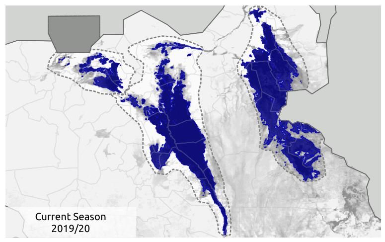
FOR FURTHER INFORMATION:
                                                                         Rogerio Bonifacio
                                                                rogerio.bonifacio@wfp.org
                                                                         +39 06 6513 3917

DATA SOURCES:
Rainfall: CHIRPS, Climate Hazards Group, UCSB
Vegetation: MODIS NDVI, EOSDIS-NASA
Land Cover: FAO GLC-Share

PROCESSING:
VAM software components, ArcGIS

                                                                                             8
You can also read