Survey of Dugong Feeding Grounds in Palk Bay, Southeast coast of India - Field Work Progress Report
←
→
Page content transcription
If your browser does not render page correctly, please read the page content below

Field Work Progress Report

     Survey of Dugong Feeding Grounds in
       Palk Bay, Southeast coast of India

              A long-term approach for Dugong Conservation in Palk Bay

Conservation Trust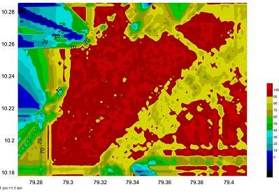
1. About this study…

This interim report provides activities and outputs of our ongoing project. We have
carried out extensive seagrass habitat mapping echo sounder survey and have been
interviewing fishers.

Our last few months of field work has given interesting thematic maps of bathymetry,
seagrass height, seagrass coverage and we discovered and mapped a micro river
canyon. Please see thematic maps at the end of this document.

The maps have given new insight into finding possible dugong feeding grounds in the
next few months. We are further looking forward new explorations and tasks with our
new underwater research equipment.

We sincerely thank Light House Foundation and National Geographic Conservation Trust
for this wonderful opportunity.
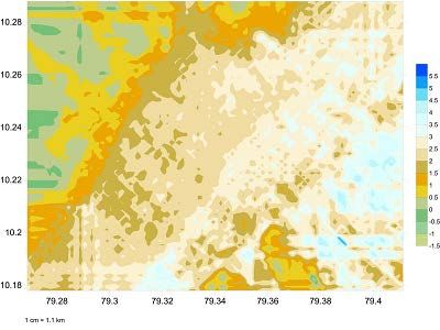
Figure 1: This photo was taken in June 2011 in our coast, a dead female dugong washed ashore in Palk Bay. This photo is a
motivation for us to do something for protecting dugongs and their habitats in our region, which becomes this ongoing project.
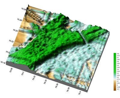
Figure 2: Map Showing study area of this ongoing project in southeast coast of India
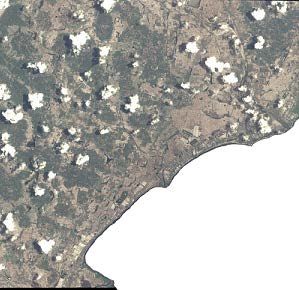
Figure 3: Survey Boat
                                                                            Figure 4: Halophila ovalis found in deeper areas. This
                                                                            species small found in areas where large seagrasses not
                                                                            found.

   Figure: 4.1. Cymodocea serrulata is the widely distributed, dominant seagrass species in the study area.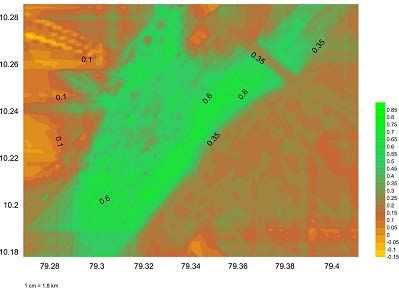
3. Results
A total area of 110 square kilometres was covered by this acoustic survey in 2013. This study found a continuous seagrass
meadows of 7278 hectares in 110 square kilometre of study area. The continuous seagrass meadows are extended very close to the
shoreline between Manora and Mallipattinam fishing ports. The seagrass beds in Sethubhavachatthiram fishing port are about 2.6
km away from shore, due to accumulation of algae in near shore. During our boat survey, we found six species of sea grasses. We
have to check for more species by systematic sampling and visual analysis with scuba diving, which is the next step from January
2014.
Already dugong death was reported in this area (Figure 1) and students visiting to our centre for monthly education events
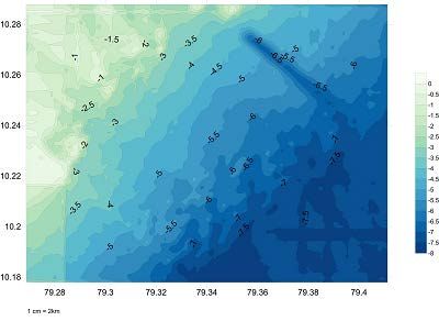
have been informing a recent death of dugongs by hunting in small fisher villages. The bathymetry map showed that the study area
has very shallow seafloor with gentle slope. Maximum depth range is about 7.5m – 8m beyond the seaward edge of seagrass beds
(Figure 5 and 6). With our random sampling, we found that the clay found in near shore area, sand clay soil found in seagrass areas
, sand found beyond seaward edge of seagrasses and patches of clay found in deeper sites (Figure 7). Maximum h e i g h t (0.8 m)
with uniform surface is found in seaward edge, where the landward edge of seagrass bed is highly disturbed by fishing pressure
(Figure 8 and 9). So, we predict that the healthy undisturbed seaward edge may be the feeding ground of dugongs.
During our fisher interviews, local fisher informed that the dugongs are not come close to the shore due to algal beds and fishing
pressures. They also suggested that the dugong feeding grounds might be located on the seaward edge of the seagrass meadow,
where the dugong gross (Syringodium isoetifolium) is growing well (Figure 10). This location is about seven km from the coast.
This survey has significantly discovered a shallow river canyon. This river canyon (named by us as “agni river canyon”) is
about three kilometre length and 0.5m width. Both sides of the river canyon are beautifully covered by seagrass beds. We are
planning to further explore this canyon by both acoustic and visual and scuba methods 2014.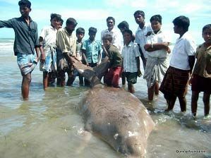
Figure 5: Showing 3D bathymetric map of the surveyed area. Slope is gentle with maximum depth is 8m. Seagrasses grow up to 7m depth.
Note the newly discovered shallow river canyon, which is uniquely covered by sea grasses on both sides.
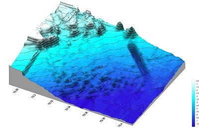
Figure 6: Showing contour bathymetric map of study area
A

                                                                          B
                                                                                                C

                                                                                                                       D

Figure 7: Showing different types of soils distributed in the study area. With our random sampling we found that the clay found in near shore
area (A) , sand clay soil found in seagrass areas (B), sand found beyond seaward edge of seagrasses (C) and patches of clay found in deeper sites
(D)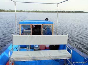
Figure 8: Showing height distribution in seagrasses meadows. Maximum height (0.8 m) with uniform surface is found in seaward edge, where
the landward edge of seagrass bed is highly disturbed by fishing pressure. So, we predict that the healthy undisturbed seaward edge may be
feeding ground of dugongs. See the dark green colour is showing large seagrasses Cymodocea serrulata and light green colour in deeper areas is
showing the small sea grasses Halophila ovalis.
Figure 9: Thematic map showing height distribution in seagrass meadows in the study area.
Canyon

Figure 10: Showing percentage cover of seagrasses. North western side has a uniform high percentage of seagrass cover. See the lack of
seagrasses in canyon. See high percentage of seagrasses in deeper edge, showing the presence of S.isoetifolium (dugong grass), which needs
to be further investigated in this study in forthcoming months.
The next phase of this ongoing study is…

   •   Checking possible dugong feeding grounds by scuba diving and underwater camera in the selected places of surveyed
       area.
   •   Deployment of acoustic autonomous recorder, if dugong feeding grounds are identified.
   •   Exploration of “Agni river canyon” and production of complete mapping.
   •   Ground-truthing of seagrass meadows based on the sites selected from thematic maps.
   •   Extension of acoustic survey to next 120 square kilometre on the south side.
   •   Compilation of fisher interview data sets to understand possible dugong sightings areas.

                                                          Report End
You can also read