The transition from Pyrenean shortening to Gulf of Lion rifting in Languedoc (South France) - A tectonic-sedimentation analysis
←
→
Page content transcription
If your browser does not render page correctly, please read the page content below
BSGF - Earth Sciences Bulletin 2021, 192, 27
© M. Séranne et al., Published by EDP Sciences 2021
https://doi.org/10.1051/bsgf/2021017

Special Issue Orogen lifecycle: learnings and perspectives from Pyrénées, Western Mediterranean and                                     Available online at:
analogues ed. O. Lacombe, S. Tavani, A. Teixell, D. Pedreira and S. Calassou (Guest editors)                                               www.bsgf.fr

The transition from Pyrenean shortening to Gulf of Lion rifting
in Languedoc (South France) – A tectonic-sedimentation analysis
Michel Séranne1,*, Renaud Couëffé2, Eglantine Husson2, Céline Baral1 and Justine Villard1
1
    Géosciences Montpellier, Université de Montpellier – CNRS, Montpellier, France
2
    BRGM, GeoResources Division, Orléans, France

             Received: 29 July 2020 / Accepted: 9 April 2021 / Publishing online: 4 May 2021

             Abstract – The Pyrenean orogen extended eastward, across the present-day Gulf of Lion margin. The late
             or post-orogenic dismantling of this orogen segment, contemporaneous with ongoing shortening in the
             Spanish Pyrénées, is still debated. Understanding the transition between the two geodynamic events requires
             to document the precise timing of the succession of the tectonic processes involved. We investigate the
             superposition of rifting structures over Pyrenean thrusts and folds in the onshore Languedoc. Compilation
             and reassessment of the regional chronostratigraphy, in the light of recent biostratigraphic dating and new
             mapping of Paleogene basins, lead to date the transition to the Priabonian. Tectonic-sedimentation
             relationship in the Eocene to Oligocene depocentres are analysed in surface exposures as well as in seismic
             reflection surveys. Bed-to bed mapping allowed us to: i) characterise an intermediate sequence of Priabonian
             age, bounded at the base and the top by unconformities; ii) evidence syn-depositional deformation within the
             Priabonian; iii) define the axes of Priabonian deformation. Interpretation of seismic reflection profiles,
             across the onshore basins covered by syn- and post-rift sequences, reveals the existence of an intermediate
             sequence displaying similar features, and that is correlated to the Priabonian. Syn-depositional deformation
             of some Priabonian basins correspond to extensional structure, whereas neighbouring, contemporaneous
             basins, reveal compressional deformation. The distribution of such apparently conflicting observations
             across the studied area provides evidence for left-lateral strike-slip deformation between two major regional
             faults (Cévennes and Nîmes faults). Left-lateral strike-slip along NE-trending faults accommodates E-W
             extension of the West European Rift (ECRIS) and part of the ongoing N-S shortening in the Central and
             Western Pyrénées. Priabonian clastic sedimentation and deformation in Languedoc witness the initial stages
             of the dismantling of the Languedoc-Provence Pyrénées, prior to Oligocene-Aquitanian back-arc rifting.

             Keywords: Pyrénées / Gulf of Lion / strike-slip basins / syn-depositional deformation / Priabonian

             Résumé – Transition entre la compression Pyrénéenne et l’extension du Golfe du Lion, dans le
             Languedoc (Sud de la France) par analyse des relations tectonique-sédimentation. L’orogène
             pyrénéen s’étendait vers l’est à l’emplacement actuel du Golfe du Lion. Contemporain de la poursuite de la
             compression dans les Pyrénées franco-espagnoles, le démantèlement tardi- ou post-orogénique de ce
             segment de l’orogène est encore mal compris. La compréhension de la transition entre l’orogénèse Pyrénéo-
             Provençale et le rifting du Golfe du Lion nécessite de préciser le calendrier des évènements ainsi que la
             succession des différents processus tectoniques mis en jeu. Nous analysons la superposition des structures
             du rifting sur les structures compressives Pyrénéennes exposées à terre, dans le Languedoc. Tout d’abord,
             nous compilons et révisons la chronostratigraphie régionale, à la lumière de datations postérieures à la
             publication des cartes au 1/50 000 du BRGM, et de la cartographie de plusieurs bassins paléogènes. Nous
             datons cette transition du Priabonien. Nous analysons les relations tectonique-sédimentation des
             dépocentres Eocène à Oligocène sur le terrain et en sismique réflexion. La cartographie banc-par-banc
             permet de : i) caractériser une séquence intermédiaire d’âge Priabonien encadrée par deux discordances, ii)
             mettre en évidence une déformation syn-dépôt dans le remplissage Priabonien, iii) définir les axes de la
             déformation priabonienne. L’interprétation de profils de sismique réflexion à travers les bassins paléogènes à
             terre, recouverts par les séries syn- et post-rift, révèle l’existence d’une séquence intermédiaire présentant
             des caractéristiques similaires et que nous corrélons avec le Priabonien. La déformation syn-dépôt de

*Corresponding author: michel.seranne@umontpellier.fr

This is an Open Access article distributed under the terms of the Creative Commons Attribution License (https://creativecommons.org/licenses/by/4.0), which permits
                           unrestricted use, distribution, and reproduction in any medium, provided the original work is properly cited.
M. Séranne et al.: BSGF 2021, 192, 27

           certains bassins est extensive, alors que dans des bassins voisins contemporains, elle est compressive. La
           distribution régionale de ces observations apparemment contradictoires est interprétée comme liée à un
           couloir de déformation en décrochement senestre entre les failles majeures des Cévennes et de Nîmes,
           d’orientation NE-SW. Ce décrochement accommode l’extension EW des rifts ouest-européens et contribue
           au raccourcissement N-S des Pyrénées franco-espagnoles, toujours actif au Priabonien. La sédimentation
           syn-tectonique clastique du Priabonien du Languedoc enregistre les premiers stades du démantèlement de la
           chaîne pyrénéo-provençale, plusieurs millions d’années avant l’initiation de l’extension d’arrière-arc.

           Mots clés : Pyrénées / Golfe du Lion / bassins sur décrochement / déformation syn-sédimentaire / Priabonien

1 Introduction                                                         outcrops that are relevant to address this question. There, the
                                                                       rare available stratigraphic data suggested that the Pyrenean
    The Pyrenean orogen results from the inversion of                  orogeny lasted until “Early Oligocene”, as reported on the
Mesozoic extensional basins, mostly formed during Mid-                 Saint-Martin-de-Londres 1/50 000-scale geological map
Cretaceous rifting and mantle denudation (Vergés and                   (Philip et al., 1978), while rifting took place in the late
Garcia-Senz, 2001; Lagabrielle and Bodinier, 2008;                     Rupelian according to the Montpellier map (Andrieux et al.,
Lagabrielle et al., 2010; Tugend et al., 2014; Chelalou                1971). Consequences of such a short delay implies: i) that
et al., 2016; Cochelin et al., 2018; Ternois et al., 2019). The        Pyrenean compression was polyphase, including a last
orogenic shortening was accommodated in the upper crust by             compressive phase, following a Late Eocene period of tectonic
reactivation of the inherited Cretaceous extensional faults, as        quiescence, and ii) rifting interrupted folding and thrusting,
thrust faults (Debroas, 1990), while the middle crust and              with no transition.
exhumed mantle were subducted beneath the European crust                   In this paper, we examine five Paleogene basins located in
(Teixell et al., 2016, 2018). The orogen extended eastwards            Languedoc, which developed at the front of the Eocene
(Ford and Vergés, 2020), in Corbières (Viallard, 1987; Lamotte         external thrusts of the Pyrenean belt and onshore of the Gulf of
et al., 2002), Languedoc (Arthaud and Laurent, 1995) and               Lion passive margin. The main objective of this contribution is
southern Provence (Lacombe and Jolivet, 2005; Bestani et al.,          to document, thanks to the revision of available biostrati-
2015), across the present-day Gulf of Lion (Arthaud and                graphic data and to detailed sedimentological, tectonic and
Séguret, 1981; Gorini et al., 1994). It was later dismantled in        seismic reflection analyses, the key period of the transition
Oligocene time to give way to the Gulf of Lion rifted margin           between the last stages of Pyrenean orogenic (mountain
(Arthaud et al., 1981; Arthaud and Séguret, 1981; Gorini et al.,       building) events and the earliest stages of rifting associated
1994; Séranne et al., 1995; Mauffret and Gorini, 1996; Mascle          with the opening of the Gulf of Lion. We aim at constraining
and Vially, 1999; Séranne, 1999; Guennoc et al., 2000;                 the tectonic setting associated with the deposition of
Lacombe and Jolivet, 2005). In the onshore Corbières area,             Priabonian continental units by analysing the tectonic-
upper crust extension is characterised by “negative inversion”         sedimentation relationships in 5 distinctive basins (Fig. 2).
of the Pyrenean thrusts, associated with deposition of                 Analyses are based on field observations (Guzargues, Les-
Oligocene-Aquitanian syn-rift sediments in the hanging-wall            Matelles, Saint-Martin-de-Londres basins) and subsurface
(Gorini et al., 1991). The crustal roots of the Pyrénées               data (Hérault and Saint-Chaptes-Gardon basins). This study
disappear eastwards (Chevrot et al., 2018) and the orogen              also relies on: i) new original investigation in the Guzargues
brutally gives way to the Gulf of Lion rift and margin, within         basin, ii) reappraisal of published works in Les-Matelles and
only tens of kilometres (Mauffret et al., 2001; Jolivet et al.,        Saint-Martin-de-Londres basins (the latter involving addition-
2020). Although documented both onshore and offshore,                  al mapping), and iii) the interpretation of ancient (1983–1992)
tectonics and kinematics of the superimposition of Pyrenean            seismic profiles tied to boreholes data in the Hérault and Saint-
structures by later rifting (Fig. 1) remains incompletely              Chaptes-Gardon basins.
understood. Transition of the compression to extension could
be driven by collapse of the elevated mountain range (Séranne
et al., 1995), it could be related to the southern propagation of
                                                                       2 Regional geological setting
the European Cenozoic Rift System (ECRIS) (Dèzes et al.,               2.1 Location of the studied area within the Pyrenean
2004), or to the onset of back-arc extension due to the NW-            orogen
dipping subduction roll-back of the old Tethyan lithosphere
(Séranne, 1999; Jolivet et al., 2020). Better constraints on               Languedoc, in the south of France, is located between the
tectonics and precise timing of the transition from the Pyrenean       Variscan basement of the Massif Central and the shores of the
orogeny to the Gulf of Lion rifting are needed in order to better      Mediterranean Sea; it links the Pyrénées (in the SW) to the
understand the origin and driving mechanism of the transition          Alps (to the NE), across the Rhône Valley (Fig. 1). Together
between the two major geodynamics events. Such data are also           with the Corbières, Languedoc forms a segment of the north
needed to constrain paleotectonic restorations (e.g. Bestani et al.,   foreland of the Pyreneo-Provençal fold and thrust belt
2015; Christophoul et al., 2016), and kinematic reconstructions of     (Arthaud and Séguret, 1981; Bestani et al., 2015).
the Mediterranean (e.g. Romagny et al., 2020).                             The Paleozoic (Variscan) basement is exposed in the
    Since most of the collapsed orogen is presently buried             Massif Central to the NW, in the Maure and Esterel massifs to
beneath the thick Neogene sequence of the Gulf of Lion                 the east. To the south, the basement has been reactivated during
margin, the onshore Languedoc provides the only geological             the Late Cretaceous to Eocene Pyrenean orogeny. It is exposed

                                                               Page 2 of 29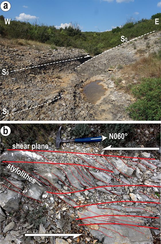
M. Séranne et al.: BSGF 2021, 192, 27

        Main extensional basins (Gulf of Lion rifting)
         Pyrenean syn-orogenic formations
        Mesozoic cover detached during Pyrenean orogeny

                                                                                                     Rho

                                                                                                                                                          Alpine
        Paleozoic basement involved in Pyrenean orogeny

                                                                                                      ne
        Unaffected during Pyrenean

                                                                                                                                                    t
                                                                                                          R.

                                                                                                                                                faul
        Alpine thrust (Mio-Pliocene)                    Massif Central                                                   lt
                                                                                                                   fau

                                                                                                                                              nce
        Normal fault (Oligocene)                                             lt                               es
                                                                         fau                              m                                              44
                                                                                                     Nî

                                                                                                                                             Dura
        Pyrenean thrusts (Eocene)                        2           s                                                                 MB.
                                                      g.          ne                       Ni                                                           Front
        Hangingwall cut-off of Pyrenean            Fi        v en
        thrust in Paleozoic                                é
                                                         C
        Pyrenean anticline
        Pyrenean compression                                                                                         P ro ve nc e
        Oligocene extension                                                Mo
                                                                     d oc
                                                                  ue
                                                             a ng
                                                           L
                                          s                                                                                       Ma
                                     è re                                                                                                                       re
                                                                                                                                                                     l
                                   i                                                                                                                       te
                                rb          Na                                Gulf of Lion margin
                             Co                                                                                                                         Es

   43                                                                                                                                                      43

               NPFZ
                                           Pe

     Pyrenees                                                                                 NW Mediterranean Sea
                                                                                                    50km
                2                                                                 4                                           5                     6

Fig. 1. Structural map southern France showing the relation between the Pyrénées and Gulf of Lion margin; modified from (Séranne et al.,
1995). Na: Narbonne; Pe: Perpignan; Mo: Montpellier; Ma: Marseille. Directions of Pyrenean shortening from Gaviglio and Gonzales (1987),
Lacombe et al. (1992), Arthaud and Laurent (1995) and Lamotte et al. (2002) and Oligocene extension from Arthaud et al. (1977), Benedicto
(1996) and Hippolyte et al. (1993).

in the Pyrénées and buried beneath the thick Neogene sequences                        developed series of E-W folds. Combined thin- and thick-
of the Gulf of Lion margin (Arthaud and Séguret, 1981; Gorini                         skinned shortening exceed 20 km in the Languedoc (Arthaud
et al., 1994; Guennoc et al., 2000) (Fig. 1). Onshore, the Variscan                   and Laurent, 1995) and 40 km in the Provence segment of the
basement is unconformably covered by Mesozoic sequence,                               orogen (Bestani et al., 2015, 2016). The Pyrénées-Provence
including at the base variable amounts of Triassic detritals and                      fold and thrust belt is segmented by NE- to NNE-trending
evaporites (Debrand-Passard and Courbouleix, 1984), which                             faults which separate areas of distinct structural styles and
have been used as decollement level during later tectonic phases.                     amounts of shortening. Left-lateral strike-slip along the
The Jurassic through to Neocomian marine marls and carbonates                         Cévennes Fault accommodated shortening of its hanging-wall
were deposited during the Tethyan rifting and subsequent                              while the NW footwall remained mostly undeformed during
thermal subsidence, controlled by NE-trending normal faults                           the Pyrenean orogeny (Arthaud and Laurent, 1995). In
such as the Cévennes, Nîmes and Durance faults. Thickness of                          Provence, the Durance Fault separates thin- and thick-skinned
the Jurassic increases southeastwards from the Cévennes fault                         Pyrenean deformation (Bestani, 2015; Bestani et al., 2016).
(less than 1.5 km), and maximum subsidence is recorded in the
hanging-wall of the Nîmes Fault, where seismic profiles show up                        2.2 Location of the studied area within the Gulf of
to 10 km of Trias to Neocomian sequences (Séguret et al., 1997;                       Lion rift and passive margin
Le Pichon et al., 2010).
     This Mesozoic sedimentary cover has been folded and                                  The studied area is affected by NE-trending normal faults
thrusted in the Pyrenean foreland, detached over Triassic                             bounding syn-rift Oligocene basins (Fig. 2). At least, some of
decollement. Thick-skinned thrusting presumably occurred                              these faults – if not all – are reactivated previous Pyrenean
close to the present day shoreline (Arthaud and Séguret, 1981;                        left-lateral strike-slips faults (i.e. the Cévennes fault, Matelles
Séranne et al., 1995; Lacombe and Jolivet, 2005), The style of                        Fault (Mattauer, 2002). Seismic reflection profiling has
the thrust and fold belt is mostly controlled by the thickness of                     shown that, during Oligocene rifting, such faults detached in
the detached Mesozoic sedimentary cover (Arthaud and                                  the Triassic decollement (Benedicto, 1996; Benedicto et al.,
Laurent, 1995): north-verging, EW-oriented thrusts dominate                           1999; Sanchis and Séranne, 2000; Husson, 2013). The
areas of thin cover ( 2.5 to 3 km) whereas thicker cover                             onshore syn-rift basins NW of the Nîmes Fault were formed

                                                                            Page 3 of 29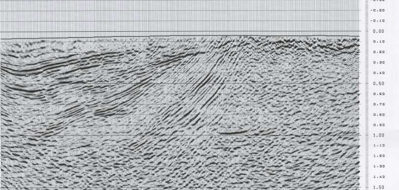
M. Séranne et al.: BSGF 2021, 192, 27
44°20’ 44°20’
Issira
c Ba
MAR sin
LSN2
n
asi
sB
Alè
LUS1
44°10’ SD101 44°10’
SD102
Alès BOT1
lt
Fig.1
au
9
sF
n ne
ve
LGC
Ga
11
Cé
Uzès
rdo
nB
as
44°00’ FG2 44°00’
in
MAI
St Chaptes
BOURDIC
Fig.21 FG1
GM02
4°40’
ult
a
eF
o nn
rc Nîmes
43°50’
St Martin de Londres Co 43°50’
-
es
Fig.13
tell
ult Sommières ult
Ma
SB1 a
sF
Fa
4°30’
me
es
up T h. Guzargues
Ni
nn
Pic St Lo
ve
Fig.7
Fig
Ce
.12
Matelles
Fig.18 Gulf of Lion Rifting normal fault
CAS1
4X undifferentiated fault (strike-slip)
H8
43°40’ 43°40’
Pyrenean Thrust
4°20’
H8
r Thr.
SBS1
Pyrenean fold axis
4F
Montpellie
Montpellier
MUR1
Seismic reflection profiles
Hérault Basin
Exploration boreholes
Pleistocene
H8
4D
SSC1
Postrift of Gulf of Lion margin (Burdigalian-Pliocene)
43°30’ 43°30’
Syn-rift of Gulf of Lion margin (Oligocene-Aquitanian)
PZS1 GAR1 4°10’ Intermediate formation (Priabonian)
PEZ1
PEZ2
CLB3
CLB2
Pézenas Pyrenean syn-orogenic fm (Maastrichtian-Bartonian)
C4 C2
CLB4
SER1
0km 10 20 30km Pre-Pyrenenan Mesozoic formations
3°30’ 3°40’ Sète 3°50 4°00’ Variscan Basement
Fig. 2. Simplified geological map of Languedoc, in the northern foreland of the Provence-Pyrénées fold and thrust belt. See location in the
regional structural framework of Figure 1. Priabonian basins according to the present study, in some areas, stratigraphic attributions are different
from the BRGM 1/50 000-scale geological maps (see text for explanation). Subsurface data used in the study is indicated fine black lines
(seismic) and open circles (boreholes); seismic profiles shown in this contribution are in bolder black line. Location of detailed maps and sections
is shown with double black line frames.
by thin-skinned extensional tectonics (Séranne, 1999). The greatly diverge in dating the end of the orogeny and the onset
basement-cover decollement ramps down in the Nîmes of the rifting. The comparison of stratigraphy of the adjacent
basement fault (Benedicto et al., 1996) and into the basement maps of the study area reveals contradicting ages for identical
ramp of the Montpellier thrust to the south and southeast of and spatially continuous formations (Fig. 3a).
the study area. Another unconsistency arises from the outstanding question:
what was the geodynamic context during the time interval
between the Pyrenean syn-orogenic deposits and the syn-rift
3 Revised chronology of events formations? Adjacent maps carry contradicting interpretations:
the “g1” is a continuity of the syn-orogenic Bartonian on the
The chronology of the transition between Pyrenean Saint-Martin-de-Londres map (Philip et al., 1978), whereas the
orogeny and the Gulf of Lion rifting is still discussed. The Montpellier map correlates the “g1” with the early stages of the
stratigraphy of the 1/50 000-scale geological maps of the study Gulf of Lion rifting (Andrieux et al., 1971).
area is confusing: all maps are consistent in identifying the The mammalian reference levels developed for the
Bartonian (e6) as a Pyrenean syn-tectonic sequence, but they Paleogene continental record of Europe (Sigé and Legendre,
Page 4 of 29M. Séranne et al.: BSGF 2021, 192, 27
a 1/50000 geological maps chronostratigraphy b Revised chronostratigraphy
North Montpellier Basins St Chaptes-Gardon-Alès Basins
Montpellier St Martin L. Sommières Anduze Uzès Alès M.Z. (Guzargues, Les Matelles, St Martin de Londres Basins)
Chat.
g3 Les Matelles St Sauveur Cruzières (Feist-Castel 1971)
g2-3 g2-3 g2-3 MP25 (Crochet & al 1984) (Charophytes)
Oligocene
«Brêche des «Brêche des g2
Matelles» Matelles»
MP24
30 g2-3
Rupelian
MP23
g1-3 ?
g1b «Calc. g1b «Calc.de g1c «calc. MP22
à chailles» Martignargues» marneux»
g1 g1 g1b «Grès
«Oligocène inf» «Gonglomérats
g1a «Grès g1a «Grès de Célas»
MP21
Oligocène inf.» de Célas» de Célas» g1a
MP20
Guzargues (Lihoreau & Tabuce, pers.comm.)
e7a2 e7b «Calc. MP19
«Calcaire e7b bitumineux» Faveirol (Rémy, 1999)
35
Priabonian
e7 «Calc. blanc» Pont de Ners (Rémy, 1999, 2005)
de Monteils»
«Ludien» e7bG «Grès MP18 St Dézéry (Rémy, 1994)
de Célas»
Paleotherium Poteau 276
e7a1 e7a «Marnes e7a «marnes Gervais (Remy pers. comm) (Crochet & al 1997) Nozières (Rémy & Lesage,2005)
«calc. à lignite» bleues»
feuilletées» MP17 St Martin L. (Charophytes) Feist in (Philip & al 1978)
«marnes à e6b «marnes
gréseuses»
Bartonian
oncolithes» MP16
e6 e6 e6 e6 e6 Robiac (Rémy & al 2015)
40
MP15
e5-6
Eocene
e5 e5 ?
Camplong (Crochet & al 1997)
e3-5 e3-5 MP14
«calc. lacustre» e3-5 «Calc. «calc. lacustre»
à Planorbes»
Lutetian
lignite ‘le Pont’(Crochet & al 1997)
MP13
Alès Aumelas (Rémy & al 2016)
45 912 St Martin (Crochet & al 1988)
1/50000 Geol. maps
setting Anduze Uzès MP12 lignite ‘exploité’ (Crochet pers.com.)
938 939
St Martin de Londres Sommières Alluvial plain Fluvio-deltaic Mudflat/saline lake
(silty marls, sandstones) (sandstones sheets) (clay, dolomite & gypsum)
963 964 Lacustrine/palustrine
Alluvial plain Fluvial/alluvial plain
Montpellier (pedogenic marls) (channelized conglomerates) (limestone and marls)
North Lacustrine
990 Alluvial plain
(algal mats, oncoliths)
Alluvial fan
(breccia & conglomerate) (mudstone, silts, shales)
Fig. 3. a: Correlation chart of the Eocene to Oligocene interval, and inferred ages, according to the BRGM 1/50 000-scale geological maps of the
study area. The inset in the lower part gives the position of the BRGM 1/50 000-scale geological maps. b: Revised chronostratigraphy of the
basins north of Montpellier (covered by the geological maps of Montpellier, St Martin-de-Londres and part of Sommières and Anduze) and of
the Saint-Chaptes-Gardon basins (maps of Alès and part of Anduze and Uzès). This is based on new mapping of the Paleogene basins (this study)
and on the compilation of biostratigraphy data, including recent discoveries of mammal fossils (references in the figure and in the text).
Biostratigraphy scale according to mammal reference levels (M.Z.). Black stars and black hexagons correspond to mammal and charophyte sites,
respectively. Simplified lithology of the formations is indicated. Colour code as in the following maps and sections of the Paleogene basins
analysed in this study. White areas correspond to non-depositional and erosional hiatuses; the Priabonian interval from Saint-Chaptes-Gardon-
Alès basins is documented in Lettéron et al. (2018).
1997), allowed to improve the stratigraphy and to revise the reference sites of Robiac provided a late Bartonian age for the
tectonic agenda of the area, especially around the transition latest Pyrenean syn-tectonic formations (Remy, 2015).
from orogeny to rifting. Figure 3b uses chronology of They pass upward to continental marls and limestones
Vandenberghe et al. (2012) and mammal reference levels of dated to the Bartonian-Priabonian transition (MP17) (Remy,
Aguilar et al. (1997). 2015; Rémy and Lesage, 2005). In the Saint-Martin-de-
The age of the lacustrine limestone was defined as Lutetian Londres basin, similar lithologies correspond to time equiva-
or slightly older. In the Pic-Saint-Loup foreland, fauna allowed lent, as suggested by charophytes (Feist in (Philip et al.,
to place this formation between MP12 and MP13 reference 1978)).
levels of the mammal reference levels (Crochet et al., 1988). The overlying formation mapped as “g1” in Les-Matelles
In different localities of Les-Matelles basin, several lignite basin, displays polygenic conglomerates and sandstones
beds provided a diversified fauna, which correlates with the within yellow marls and silts, including several lignite beds.
Lutetian (MP13) (Crochet et al., 1997). A distinctive marly They are interpreted as alluvial plain deposits (Benedicto et al.,
facies including 1 to 20 cm diameter oncolithes, occurs at the 1999; Egerton, 1996). The age of this formation was subjected
top. It has yielded fauna ascribed to the MP14 reference level to discussion due to the controversial location of the discovery
(Crochet et al., 1997) of latest Lutetian age. This facies passes by Gervais, in the late XIXth Century, of a Lophiodon skull
southwards and upwards to the Bartonian syn-orogenic (see review in (Hartenberger et al., 1969). Reappraisal of the
breccia, exposed along the Montpellier thrust (Andrieux specimen, exhumed from Lyon university collections by
et al., 1971). In the Sommières and Saint-Chaptes basins the J.A. Remy (personal communication), relates the specimen to
Page 5 of 29M. Séranne et al.: BSGF 2021, 192, 27
Map
EPOCH Stage Thickness Lithology, sedimentological features
notation
OLIGOCENE Rupelian g2-3 >100m Alluvial breccias and marls
500
400
EOCENE Priabonian g1 200-300m Fluvial conglomerates, sandstones and alluvial marls with paleosols
and with oncoliths (base)
300
EOCENE Bartonian e6 max.30m Marls with oncoliths and calcarenitic layers
200
EOCENE Lutetian e3-5c 80-100m Palustrine to lacustrine limestones («calcaires lutétiens»)
100
EOCENE e3-5m up to 80m Continental clays and marls («Marnes infra-lutétiennes»)
PALEOCENE (e1) (Breccias)
LOW CRET. Valanginian n2c 100-150m Marine marly limestones
0m
Fig. 4. Generalised lithostratigraphy of the Late Mesozoic and Paleogene in the Guzargues Basin and immediate surrounding.
MP18 (middle Priabonian). Another Lophiodon specimen has interval, dated to the Priabonian. In particular, the fluvial
recently been discovered in the correlative “g1” formation in conglomerate and yellow sandy marls (reported on the
the Guzargues basin, and has been related to the MP19 published maps as “g1”, Fig. 3a), correlate with, and are
reference level (R. Tabuce and F. Lihoreau, personal commu- the proximal equivalent of the lacustrine delta sandstones
nication). The age of this conglomerate formation is therefore “Grés de Célas” of the Alès Basin (Lettéron et al., 2018). This
attributed to the Priabonian. As first suggested by Andrieux formation is intermediate between the syn-orogenic Pyrenean
et al. (1971), it is correlated with the detrital continental (Bartonian) and the syn-rift (Late Rupelian) deposits.
formation “Grès de Célas” of upper Priabonian, in the Furthermore, it is bounded by two marked angular uncon-
Sommières and Saint-Chaptes-Gardon basins, northeast of the formities, the upper one corresponding to a several-million-
study area, which spans the MP18 to MP19 (Rémy, 1985; years hiatus.
Remy and Fournier, 2003; Rémy and Lesage, 2005). In the following, we examine key field evidence in the
At Les-Matelles and Saint-Vincent-de-Barbeyrargues north-Montpellier area (Guzargues, Les-Matelles and St-
localities, yellow to orange marls interfingering with syn-rift Martin-de-Londres basins, respectively) where the tectonic
breccia, contain charophytes (Grambast, 1962), teeth of small sedimentation relationships allow to characterise this interme-
mammals (Thaler, 1962) and gastropods (Rey, 1962) that diate formation. It can be interpreted as the record of the
yielded mid- to late- “Stampian” age, which corresponds to the transition between the Pyrenean orogeny to the Gulf of Lion
Late Rupelian. This age was later confirmed by the discovery rifting.
of small mammals in Les-Matelles half-graben, that relate to
MP25 mammal scale (Crochet, 1984). In addition, breccia
pipes and dykes of intracontinental alcaline basalt, that intrude 4 Tectonic and sedimentation in the
Lutetian and Priabonian formations, were dated 24 to 28 Ma
(Gastaud et al., 1983), and have been related to the Late
Guzargues Basin
Rupelian rifting event (Séranne, 1999; Dautria et al., 2010). In 4.1 Lithostratigraphy of Eocene deposits in the
the northern basins, this unconformable formation has not yet Guzargues area
provided mammal remains, but Charophytes from the alluvial
environments of Saint-André-de-Cruzières in the north of Alès The Guzargues basin (Fig. 2) has not been the topic of any
Basin yielded an Oligocene age (Feist-Castel, 1971). specific study and remains poorly documented. The Paleogene
Reappraisal of ancient specimens and new discoveries thus sedimentary succession contains 4 main lithological units
indicate that the sequence made of marls, sandstones beds and representative of the regional geodynamic history since the
polygenic channelized conglomerates, which is exposed in early stages of the Pyrenean compression to the main rifting
separated basins across the study area, belongs to the same phase (Fig. 4). When possible, all of them were precisely
Page 6 of 29M. Séranne et al.: BSGF 2021, 192, 27
mapped to analyse the geometrical relationships of Priabonian heterometric, sub-rounded to well-rounded clasts, mainly
deposits with under- and overlying units. composed of local Mesozoic (Upper Jurassic to Lower
Cretaceous) carbonates. In some places, they also show
– Paleocene to Lower Eocene facies are represented by abundant oncoliths (as fragments or complete specimens)
fluvial marls with interbedded sandstones and palustrine probably originated from the underlying Bartonian formation.
limestones (“Marnes infra-lutétiennes”), only few tens of In the upper part of sections, conglomeratic bodies in Gm
metres thick in the Guzargues area. They are usually facies unit are thinner (< 1 m) and laterally more continuous
correlated to alluvial fan syn-tectonic breccias, reworking (usually more than 10 m in width) than in the lower part. In
the Jurassic succession at the front of the Montpellier addition to local Mesozoic carbonates, quartz and lydite,
thrust, and thus deposited during the early stages of the originated from Cévennes and/or Montagne Noire Paleozoic
Pyrenean compression. peripheral units, and ginger (Aptian?) sandstones represent a
– Massive whitish Lutetian limestones, up to 100 m thick in significant proportion of clasts in channel fillings.
the area, form an easily recognised, continuous unit Gu conglomerates can be interpreted as channel lag (Miall,
displaying folds produced by late stages of the Pyrenean 1977, 1978; Nemec and Postma, 1993). The Gm and Gt facies
compression. units present strong similarities with gravel bars in braided
– Lutetian limestones are conformably capped by a singular streams (Miall, 1977; Nemec and Postma, 1993; Mack and
unit, up to 30 m thick, made of lacustrine to shallow Leeder, 1999). Sp cross-bedded sandstones are typical of
marine, marly facies containing oncoliths and calcarenitic megaripples deposited by a unidirectional upper to lower flow
layers, Bartonian in age. regime (Simons et al., 1965; Southard, 1991) produced by
– Topmost deposits of the Paleogene succession in the subaerial to subaqueous, stream and/or sheet flows (Mack and
Guzargues area correspond to Priabonian fluvial deposits Leeder, 1999; Hampton and Horton, 2007). Inferred FA1
showing alternations of conglomerates, sandstones and depositional environments are thought to belong to an alluvial
marls, up to 300 m thick. Pebbles are supplied both from fan setting, first supplied by a local catchment area (lower part
distant Pyrenean sources and from local Mesozoic of sections), and then by a regional catchment area (upper part
carbonates. These deposits rest unconformably above the of sections).
Pyrenean folds consisting of Lutetian to Bartonian units. FA2 corresponds to the alternation between (i) moderately
sorted, medium- to coarse-grained sandstones with sub-
rounded clast lenses (Sst; Tab. 1), and (ii) medium- to
One kilometre to the south, the northern edge of the coarse-grained cross-bedded sandstones (Sp; Tab. 1). If local
neighbouring Assas basin shows a sedimentary unit of strong (Mesozoic but also Lutetian) calcareous elements still
geodynamic significance, which is missing in the Guzargues represent an important proportion of clasts (granules, gravels,
basin. Close to the Assas village, Oligocene breccias and pebbles), siliceous component (quartz and lydite gravels) is
marls, usually interpreted as syn-rift deposits, unconformably more abundant than in FA1. FA2 depositional processes are
overlie Priabonian continental facies. dominated by tractional transport under a unidirectional upper
Thus, the Priabonian deposits of the Guzargues basin, flow regime, with episodic sheet flows. Inferred depositional
bounded below and above by unequivocal syn-tectonic units, environments correspond to the proximal part of a subaqueous
represent a key unit to study the transition between two main alluvial fan to fan delta, with sediment supplied from both local
regional geodynamic events. and regional catchment areas.
FA3 is mainly represented by yellowish, greenish or
4.2 Sedimentological features of Priabonian deposits reddish silty clays, with plastic texture at some places, in which
in the Guzargues basin are interbedded thin layers of well-sorted siltstones and fine-
grained sandstones (Fm; Tab. 1). Carbonate pedogenic nodules
As observed in the 10 sections studied in the Guzargues locally form scarce, up to 1 m thick, distinctive layers (P; Tab.
basin, Priabonian deposits are basically made of eight 1). Interbedded massive fine-grained sandstones (Sr; Tab. 1)
lithofacies units distinguished by their lithology and sedimen- usually show vertical root traces and more rarely asymmetrical
tary structures. Each lithofacies is described and interpreted in ripple cross-laminations several centimetres thick at the top.
terms of depositional processes (Tab. 1), and most are FA3 deposition must be the result of vertical settling from
illustrated in Figure 5. detrital suspensions in standing water (Horton and Schmitt,
Lithofacies units are often associated together, defining 1996; Miall, 1977). Fine-grained sandstones showing asym-
three main facies associations (FA1, FA2, and FA3), the metrical ripples and interbedded silty and sandy layers suggest
distribution of which varies depending on the spatial location episodic flow regime, related to sheet flood events. The
in the Guzargues basin and on the vertical position into the occurrence of carbonate nodules records occasional pedogenic
Priabonian stratigraphic succession. processes and temporary aerial exposure. Assuming these
FA1 is represented by the alternations of (i) channel- depositional processes, FA3 should have been deposited in the
shaped, poorly to weakly sorted conglomerates (Gu, Gt; distal part of a subaqueous to subaerial alluvial fan, or in a
Tab. 1), (ii) matrix-rich, stratified conglomerates (Gm; Tab. 1), floodplain laterally to major braided distributaries.
and (iii) medium- to coarse-grained, cross-bedded sandstones The 10 studied sections show vertical variations in the FA
(Sp; Tab. 1). A general trend in the vertical evolution of FA1 succession (basically FA1-FA2 or FA2-FA3 alternations)
facies units is recognised through most of the studied sections. forming elementary sequences between several metres and
In the lower part of sections, predominant Gu/Gt conglomer- tens of metres thick (Fig. 6). As indicated by the various
atic channels, up to 3 m thick and 3 to 5 m wide, contain inferred depositional environments for FA, these elementary
Page 7 of 29M. Séranne et al.: BSGF 2021, 192, 27
Table 1. Summary of the main facies features observed in the Priabonian deposits of the Guzargues basin, and interpretations in terms of
depositional processes.
Facies code. Facies name Lithology Sedimentary structures Depositional processes
Gu. Poorly sorted, massive, channel- Poorly sorted, massive, Well-defined basal erosional surfaces Channel-lag deposits under
shaped conglomerates (Fig. 7A) locally normally graded with gutter/scour structures. subaerial flashy braided-
conglomerates. Channels displaying few clast stream flows (Barrier
Highly heterometric, sub- imbrications, 50 cm up to 3 m in depth, et al., 2010)
rounded to well-rounded 3 to 5 m in width.
clasts (pebbles to small
boulders), mainly
composed of local
Mesozoic (Upper Jurassic
to Lower Cretaceous)
carbonates.
Gt. Weakly sorted, cross-bedded, Clast-supported, stratified Fining upward infill. Minor channel fills (Miall,
stratified conglomerates with coarse- conglomerates. Trough cross-bedding. 1978).
grained sand lenses (Fig. 7B) Weakly sorted, Transverse- or diagonal-
heterometric, subrounded bar deposits under
clasts (granules to small subaerial perennial
boulders of Mesozoic braided-stream flows
carbonates). (Barrier et al., 2010).
Occurrence of poorly
sorted lenses of coarse-
grained sand matrix
surrounding individual
pebbles.
Gm. Matrix-rich, normally gradded, Matrix-rich, normally Some beds with horizontal alignment of Longitudinal-bar deposits
stratified conglomerates (Fig. 7C) graded, stratified clasts. under subaerial competent
conglomerates. Few clast imbrications into horizontal and perennial braided-
Poorly sorted, subangular foreset strata. stream flows (Barrier
to subrounded clasts “Gradual” basal surfaces. et al., 2010)
(granules to cobbles) made
of local Mesozoic
carbonates, common
siliceous (quartz) clasts
(originated from Cévennes
and/or Montagne Noire
Paleozoic peripheral units)
and ginger (Aptian?)
sandstones.
Sst. Moderately sorted, medium- to Moderately sorted, Fining-up trend. Bar deposits under
coarse-grained, cross-stratified medium- to coarse-grained Cross-stratification with grading subaerial sheet flows or
sandstones with lenses of subrounded sandstones. foresets. stream flows.
gravels and pebbles (Fig. 7C) Layers (and lenses) of Well-defined internal erosional surfaces.
well-sorted subrounded
clasts (granules to pebbels)
composed of Mesozoic
carbonates, some Lutetian
mudstones and common
Bartonian oncoliths as
fragments or complete
specimens.
Sp. Medium- to coarse-grained, cross- Weakly sorted, medium- Cross-stratification. Megaripple deposits under
bedded sandstones (Fig. 7E) to coarse-grained Internal erosional surfaces. subaerial sheet flows or
sandstones which can Few small scour structures. stream flows.
contain scattered granules
at the base.
Sr. Massive, pedoturbated, well-sorted, Massive, well-sorted, fine- Pedoturbation (root sleeves,
fine-grained sandstones (Fig. 7D) grained sandstones. destructuration of primary sedimentary
Page 8 of 29M. Séranne et al.: BSGF 2021, 192, 27
Table 1. (continued).
Facies code. Facies name Lithology Sedimentary structures Depositional processes
structures by root growth). Ripple deposits under
Locally few asymmetrical ripples at the subaerial sheet flows or
top. stream flows.
Fm. Massive, silty claystones with Reddish to yellowish (also Fining-up grading in siltstone to fine- Deposits from suspension
planar siltstone to fine-grained purplish red in some grained sandstone layers. fallout in a floodplain.
sandstone layers (Fig. 7D) horizons of plastic Overbank or waning flood
texture), massive, silty deposits (siltstones and
claystones with few thin very fine-grained
(millimetric to centimetric) sandstones).
layers of well-sorted
siltstones and very fine-
grained sandstones.
P. Pedogenetic carbonate nodules Indurated, cm to dm Vertical root casts. Soil (Miall, 1978) or
(Fig. 7F) carbonate nodules, often temporary vegetalized
scattered within plastic surface.
claystones, sometimes
coalescent to form
continuous carbonate
horizons.
Gm, Gt, Sp, Sr, Fm and P are abbreviations from the facies code provided by Miall (1978).
Gu and Sst are abbreviations defined by Barrier et al. (2010).
sequences, made up of alternate proximal and distal deposits, from the anticline (Figs. 7 and 9a). The upper conglomeratic
are arranged into overall trends measuring several tens of interval, corresponding to the final progradational trend
metres thick, recording progradational and retrogradational recorded by Priabonian deposits, progrades northwards across
evolutions. the whole basin, over a silt and shale interval and seals the
At the scale of the Guzargues basin, the large FA Lirou anticline (Fig. 6). Folding affects the Lutetian lacustrine
alternations are describing a whole progradational, then limestones, and the top of the Lutetian is eroded in the crest of
retrogrational, and finally progradational evolution, which is the anticline. Variable thickness of Latest Cretaceous to Early
easily recognised on the field. These trends were used to Eocene marls suggests a decollement with the underlying
correlate Priabonian deposits at basin scale and, combined with monocline Valanginian limestones. The latter is affected by a
aerial photograph interpretation, to produce a detailed sub-vertical, NE-trending fault, which displays a left-lateral
geological map that allows building cross-sections. component of movement (Fig. 8 – section 3). These
observations lead to the following points: i) folding was
4.3 Tectonic-sedimentation relationships in the initiated during Pyrenean shortening, and was still active
Guzargues basin during deposition of the early Priabonian; ii) folding of the
Paleogene sequences is detached above the Valanginian
The detailed geological map (Fig. 7) and cross-sections limestone, through a detachment within the Late Creta-
(Fig. 8) of Guzargues basin show sequences of Priabonian ceous-Early Eocene marls; iii) folding is related with a NE-
conglomerates interfingering with marls, that are involved in trending left lateral strike-slip.
gentle folding of complex geometry. To the south, the basin is The southeastern boundary – Figure 10 shows up to three
separated from the contemporaneous Assas Basin by a NW-SE stacked, angular unconformities, which affect the lower
anticline, cored by Valanginian (Figs. 7 and 8 – section 1). Priabonian sequences along the southern flank of an EW
North-south sections of Guzargues basin (Fig. 8 – sections 2 syn-sedimentary syncline. These angular unconformities pass
and 3) display an asymmetrical syncline structure: the southern northwards to correlative conformities, while they converge
limb is steeply dipping north, whereas the northern limb southwards, towards the basin boundary, corresponding to an
extends over 3 to 4 km in a gently dipping or subhorizontal E-trending anticline of Lutetian limestone. This anticline is
position. In addition, the basal part of the Priabonian is affected locally eroded by a present-day transverse valley, but mapping
by ENE-trending anticlines, while the youngest conglomeratic reveals that sub-horizontal Priabonian conglomerates are
Priabonian seals the anticline (Fig. 8 – section 3). exposed within this valley and that they laterally onlap onto
The Lirou anticline – The Bartonian and the base of the the incised carbonates (Fig. 7). Clasts imbrication within the
Priabonian sequence (isolated sandstone and conglomerate fluvial conglomerates indicates a consistent northwards
beds in marls) are wedging towards an anticline with an EW- paleocurrent in the paleo-valley. Very thin (several tens of
oriented, W-plunging axis. Conglomerate beds isolated in the metres) in the transverse valley, the Priabonian formation
silt and marls are observed on-lapping both flanks of the thickens rapidly northward within 1 kilometre distance, from
anticline (Fig. 6), and they display diverging bedding away less than 300 m to 450 m, and it exceeds 600 m in the syncline
Page 9 of 29M. Séranne et al.: BSGF 2021, 192, 27
Page 10 of 29M. Séranne et al.: BSGF 2021, 192, 27
Fig. 5. Photographs of outcrops illustrating some typical facies observed in the Priabonian deposits of the Guzargues basin. A: Facies Gu with
carbonate clast alignment underlining tenuous cross-beddings. Note scours at the base of the channel (arrows). B: Facies Gt showing progressive
transition between (base) unsorted, highly heterometric massive, stratified conglomerates, and (top) weakly sorted, cross-bedded conglomerates.
C: Alternations between (Sst) cross-stratified sandstones with lenses of scattered subrounded gravels and pebbles, and (Gm) matrix-rich, graded,
stratified conglomerates with weakly sorted pebbles mainly made of Mesozoic carbonates. D: Reddish to yellowish laminated silty claystones
(facies Fm) with intercalation of a decimetric layer of massive fine-grained sandstones (facies Sr). E: Medium- to coarse-grained cross-bedded
sandstones typical of facies Sp. F: 50 cm-thick carbonated horizon showing well-preserved, vertical root casts, probably derived from
vegetalization on top of massive fine-grained sandstones (Sr). Note the occurrence of several pedogenetic carbonate nodules above the irregular
top surface of the carbonated sandy horizon.
Fig. 6. Detailed stratigraphic correlation of Priabonian deposits along a 2 km-long N-S transect at the southeastern border of the Guzargues
basin, showing differential subsidence and onlap geometries induced by the syndepositional growth of the Lirou anticline. See Figure 7 for
location of logs. Horizontal correlation lines set at the maximum of progradation recorded by several meters-thick, stacked conglomeratic
channels that closely rests on Lutetian limestones at the apex of the Lirou anticline.
axis. In addition, fluvial conglomerate belts pass laterally and across the entire Guzargues basins show that the northern sub-
distally (northwards) to silts and marls of alluvial plain facies. basin represents the youngest depocentre of the whole basin
These observations clearly show that: i) the syncline was (Fig. 8 – section 1). To the NW, Priabonian is directly in
formed during deposition of the Priabonian; ii) the basin was contact with the Mesozoic carbonates through a sub-vertical
fed by a north-flowing paleoriver, incised into the growing faulted boundary. In the Serre de Moujes, outcrop in the
Lutetian limestone E-W anticline. damage zone of the bordering fault reveals sets of associated
Serre de Moujes – The northern part of the basin fractures and dissolution surfaces, consistent with a left-lateral
corresponds to a syncline trending N020°, that involves strike-slip motion (Fig. 9b). Unfortunately, no slickenside
Lutetian limestones and Priabonian conglomerates (Fig. 7). could be observed to constrain the respective vertical and
The conglomerates are more developed on the steep western horizontal components of slip. Saint-Bauzille-de-Montmel
flank, where they unconformably rest over the steeply dipping borehole (located 1.5 km north, along strike) constrains a
Lutetian limestones, and they grade eastwards to distal silts curved geometry for this fault and provides evidence for a
and marls (Fig. 8 – section 4). Along the eastern flank of the 700 m vertical offset (Fig. 8 – section 4). Considering the fault
syncline, Priabonian formations are onlapping onto the geometry and the kinematic observations on the outcrop, a
Lutetian limestone; in addition, the Bartonian oncolith dominantly strike-slip movement along this bordering fault is
formation is transgressed towards the north by the Priabonian. suggested during Priabonian and the important vertical offset
Onlapping surfaces point to a pre-existing synform of Lutetian implies several kilometres of cumulated lateral offset. A
limestones prior to Priabonian deposition. The conglomerate significant part of such offset may be inherited from earlier
belt is separated from that of the main part of the basin, (Pyrenean) tectonic phases. These observations argue for i)
suggesting the presence of a smaller, northern, sub-basin with a deposition of Priabonian syn-tectonic sediments in a hanging-
distinct feeder that supplies clastic sediments across the wall syncline, controlled by the activity of the N020°-trending
western boundary (Fig. 8 – section 2). Unfortunately, no clear bounding fault, and ii) accommodation of a significant amount
evidence of paleocurrent was found. North-south correlations a left-lateral strike-slip, by this inherited fault.
Page 11 of 29M. Séranne et al.: BSGF 2021, 192, 27
Fig. 7. Detailed geological and structural map of the Guzargues basin (north of Highway D68, while Assas sub-basin is located south of the
highway). Location of the sedimentological logs 1 to 9 reported in Figure 6 is indicated by fine black rectangles. Position of the structural cross-
sections extremities (Figs. 8 and 9) is given by black arrows.
4.4 Tectonics–paleoenvironment relationships in the canyon across a growing anticline, which separates Assas (to
Guzargues basin the south) and Guzargues basins. The belt of northward-
flowing fluvial channels preferably occupied the most
Figure 11a provides a synthetic view of the paleoenviron- subsiding parts of the basin: i) in the south, parallel to the
ment distribution across the Guzargues Basin during Priabo- bordering growing anticline and, ii) in the overall N-trending
nian. Fluvial sediments were delivered through an incised axis of the syn-depositional syncline. The latter was controlled
Page 12 of 29M. Séranne et al.: BSGF 2021, 192, 27
Fig. 8. Structural sections across the Guzargues basin; see location in Figure 7.
by a set of NNE-trending faults which display map- and sequence is therefore controlled by folding of the Mesozoic
outcrop-scale evidences of normal faulting and left-lateral through the Lutetian cover detached over the Triassic
strike-slip. The secondary fluvial conglomerates depocenter of decollement, corresponding to an overall transcurrent, left-
Serre de Moujes, in the northern part of the basin, witnesses an lateral kinematics, along the NNE-trending faults (Fig. 11b).
additional fluvial input to the basin, across a relay or a jog in The kinematics documented in the Guzargues basin result from
the bordering fault system. The syn-depositional Priabonian NS shortening combined with EW extension.
Page 13 of 29M. Séranne et al.: BSGF 2021, 192, 27
Les-Matelles-Corconne Fault of some 375 m, during Priabo-
nian (Benedicto et al., 1999).
In the southernmost part of the basin, Priabonian
unconformably overlies the syn-orogenic breccia of Paleocene
age, related to the activity of the Montpellier thrust (Andrieux
et al., 1971). In the central segment of the basin, Priabonian is
conformable over the distal syn-orogenic marls and oncoliths
of Bartonian age. Finally, in the northern extension of this
basin, Priabonian is unconformable over Neocomian marly
limestones, which are deformed by EW-trending compres-
sional structures. Such folds and thrusts are correlated to the
Pic-Saint-Loup thrust, active during Bartonian (Philip et al.,
1978). Considered at the scale of the basin, the Priabonian is
thus unconformable over pre-Pyrenean deformed series, as
well as syn-orogenic Pyrenean sedimentation. Finally, the syn-
rift Late Rupelian breccia is unconformably overlying the
Priabonian (Crochet, 1984).
5.2 Saint-Martin-de-Londres basin
Saint-Martin-de-Londres basin (SMLB) extends in an EW
asymmetric syncline, immediately north of the Pic-Saint-Loup
thrust, a structure of the Pyrenean fold and thrust belt (Fig. 2).
Above an unconformity over the Neocomian, the basin
sequence starts with continental marls and thin beds of
lacustrine limestones of latest Cretaceous to Paleocene age
(Crochet, 1984; Freytet, 1971; Philip et al., 1978), which are
the distal correlative of the syntectonic “Vitrollian” breccia,
deposited along the Montpellier thrust.
Lutetian lacustrine limestones, transgressive over Late
Jurassic to Paleocene formations, form an 80 m to 100 m-thick
slab that designs a wide, low amplitude, EW-oriented syncline
(Fig. 13). The overlying breccia, dated to the Bartonian (Philip
et al., 1978), consists of local, late Jurassic, Neocomian and
Lutetian limestones, derived from erosion of the active Pic-
Fig. 9. a: Internal onlap within the Priabonian conglomerates, which Saint-Loup thrust front. They pass northwards to distal
illustrates syndepositional folding of the Lirou anticline. Location on continental marls and silts, which present syn-tectonic growth
map Figure 7. b: Penetrativve deformation of the Jurassic limestones structures. The southern boundary of the basin has been
along the basin-bounding fault, indicating left-lateral kinematics. intensely folded and faulted in relation with the Pyrenean Pic-
Serre de Moujes, location on map Figure 7. Saint-Loup thrust, during Bartonian time (Fig. 14). The
Priabonian sequence unconformably overlies the Bartonian
breccia; to the east, it seals an intra-Bartonian thrust
5 Les-Matelles and Saint-Martin-de-Londres propagation fold (Fig. 13), which requires erosion of the
Pyrenean-related structure prior to Priabonian deposition.
Priabonian basins Along the southern margin of the SMLB, the Priabonian
5.1 Les-Matelles basin sequence designs an asymmetric syncline with sub-vertical to
overturned southern limb (Figs. 15a and 15b). The sequence
The overall geometry of Les-Matelles basin (LMB) is that starts with a thin level of finely laminated limestone that
of an Oligocene syn-rift hanging-wall syncline, controlled by a contains bioclasts and charophytes characterising a lacustrine/
NNE-trending normal fault (Fig. 2), known as the Matelles- palustrine environment. Laterally, the limestone passes to
Corconne Fault (Benedicto et al., 1999). The Priabonian thicker and more massive beds of lacustrine mudstone. The
sequence mostly consists of marls and siltstones with rare thin basal limestone is correlated to the north of the basin, with
conglomerate beds. Paleocurrent measurements in the chan- 10 m to 15 m thick marls and carbonates deposited in an arid,
nelized fluvial conglomerates indicate northwest to northeast evaporitic environment. Above the limestones, along the
flowing channels (Egerton, 1996). Detailed mapping central southern margin only, are found grey marls including
(Benedicto, 1996) revealed that the underlying Priabonian several thin beds of glauconitic sandstones with bioclasts and
sequence also presents growth structures in an asymmetric rare foraminifera (Egerton, 1996). This shallow marine
syncline, that displays a NW limb steeper (≥ 40°) and thinner sandstone passes upwards to marls and siltsones including
than the SE limb (Fig. 12). Sequential tectonic restoration of thin bioturbated sandstone beds, deposited in a floodplain,
transverse sections indicates an extensional offset across similar to those described in LMB. In the upright, southern
Page 14 of 29M. Séranne et al.: BSGF 2021, 192, 27
Fig. 10. Detailed structural section in the south of Guzargues basin showing growth syncline and internal angular unconformities. See location
of section 5 in Figure 7.
Fig. 11. a: Sketch map of the paleoenvironments in the Guzargues basin, in relation with the Priabonian tectonics. b: Conceptual tridimensional
representation (no scale intended) of the interaction between Priabonian kinematics and sedimentation in the Guzargues basin. Braided fluvial
conglomerates accumulate in the most subsiding parts, i.e. the actively deforming synclines that affect the Mesozoic-Lutetian cover, detached
over the basement. See text for explanations.
limb of the syncline, these sandstone beds are affected by small been identified in Les-Matelles and Montferrier Priabonian
scale reverse faults (Fig. 15c). They also display soft outcrops, are imbricated under the influence of north to
penetrative deformation of initially cylindrical root traces northwestwards paleocurrents (Egerton, 1996), and thus
(Fig. 15d), which indicate an early, pre-lithification, N-S correspond to a southerly derived material (Freytet, 1971).
shortening prior to folding. Finally, up to 50 m stacked, The Priabonian sequence of SMLB unconformable over
channelized conglomerates, are deposited in several-metres- Pyrenean structures, and containing clasts supplied by a
thick levels, interbedded with siltstones and marls. The high southerly derived sedimentation was deposited in a N-S
ratio of channelized conglomerates vs floodplain marls and compressional setting, related to reactivation of the Pyrenean
siltstones is more in line with Guzargues than with Les- Pic-Saint-Loup Thrust.
Matelles basins. Conglomerates are clast-supported and rather
well-sorted. Clasts are polygenic, including significant number
of quartz veins and black cherts, derived from the Paleozoic 6 Seismic sequence analysis of the Hérault
deformed basement. Distinctive clasts of glauconitic sand- Basin
stones and calcarenites containing Albian orbitolines cannot be
related to any local source, as the Mesozoic sequence is The Hérault Basin (HB) is a NNE-SSW asymmetric half-
interrupted above the Valanginian due to the regional erosion graben developed along the Cévennes Fault, formed in relation
of the Durancian Isthmus (Husson, 2013). Such clasts, also with the rifting of the Gulf of Lion (Arthaud et al., 1981;
Page 15 of 29You can also read