Caractérisation des événements passés de submersion pour l'estimation des aléas présents et futurs : utilisation conjointe des approches ...
←
→
Page content transcription
If your browser does not render page correctly, please read the page content below
Caractérisation des événements passés de submersion
pour l'estimation des aléas présents et futurs : utilisation
 conjointe des approches historiques, statistiques et de
                      modélisation

Déborah Idier, Jérémy Rohmer, Rodrigo Pedreros, Sylvestre Le Roy,
Jérome Lambert, Jessie Louisor, Gonéri Le Cozannet, Erwan Le Cornec*

                                                                           Fond : Photo IGN, 2013
                          GT Tempêtes & Submersions Historiques
                                       17/12/2020                      *
                                        Webinar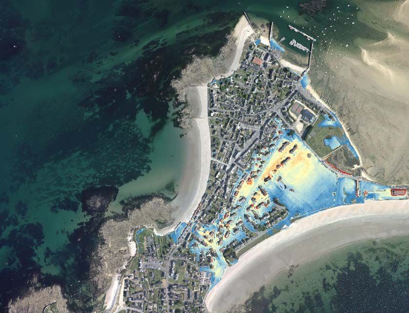
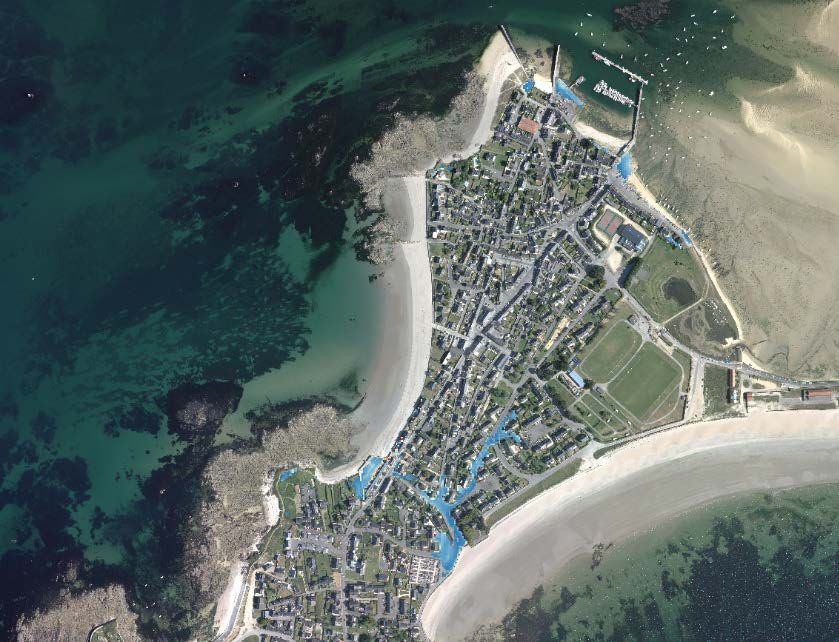
THE STUDY SITE

                 Gâvres
                 • Macro-tidal
                 • Most recent massive flooding: Johanna
                  storm, 10th March 2008, ~120 flooded
                  houses
                 • Main flood regime: wave overtopping

                                                           Fond : Photo IGN, 2013
                                                           2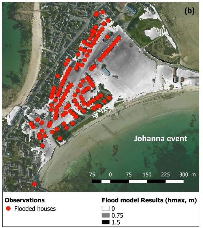
THIS STUDY

• Objective: understand drivers of past (and future) flood events in Gâvres
• Period of interest: 1900-2010
• Approach: building and cross-fertilization of 3 databases

          Damage event              Hydro-meteorological             Modelling of past
            database                     database                    (flood/no flood)
                                                                      damage events

                            Comparison, validation, cross-fertilization

                •   Critical hydro-meteorological conditions for flood
                •   Probability of the hydro-meteorological conditions that let to flood events
                •   Impacts of past and future sea-level rise
                •   …

                                                                                                  3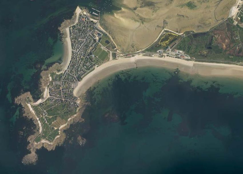
THE FLOOD MODEL

Input: water levels, waves, wind.
                                                 WW3
                                                                    Niveau d’eau
Modeling workflow:                                                  (NMR+T+S)
                                                                     Vent
   •   WW3 propagates the offshore wave                             (U,Dw)
       conditions, taking into account the             Vagues
       wind and still water level (NMR+T+S).           (Hs,Tp,Dp)

   •   Wave parameters (Hs,Tp,Dp)
       extracted along the SWASH
       computational domain.
   •   SWASH run with the non-uniform          SWASH
       wave boundary conditions, the still
       water level and wind.
         • dx=3m & f~10Hz
         • Default: topography
           representative of the 2008
           coastal defenses.

                                                                                   4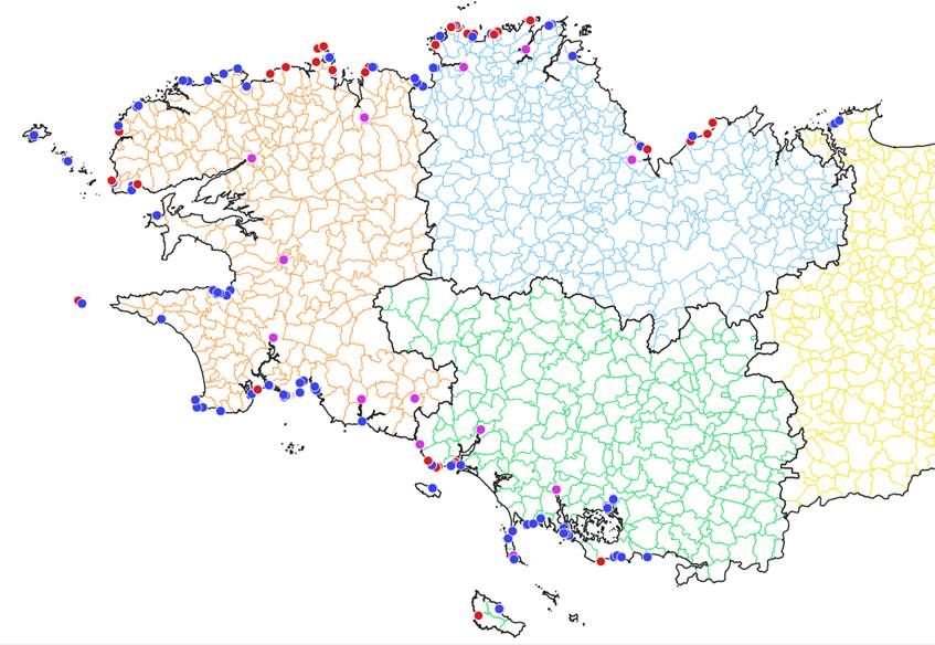
THE FLOOD MODEL

Validation
on the            Simulation over 6h (HT +/- 3h)
2008
johanna
event

                                                   5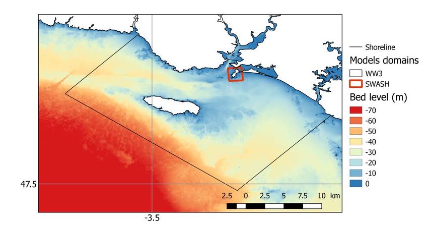
THE FLOOD MODEL
Input: water levels, waves, wind.
WW3
Niveau d’eau
Modeling workflow: WW3-SWASH. (NMR+T+S)
Vent
(U,Dw)
Vagues
(Hs,Tp,Dp)
For the modeling database:
• A flood indicator (Vol): water
volume entering inland at high SWASH
tide (over 10 min).
• Vol computed for each event of
the damage event database.
6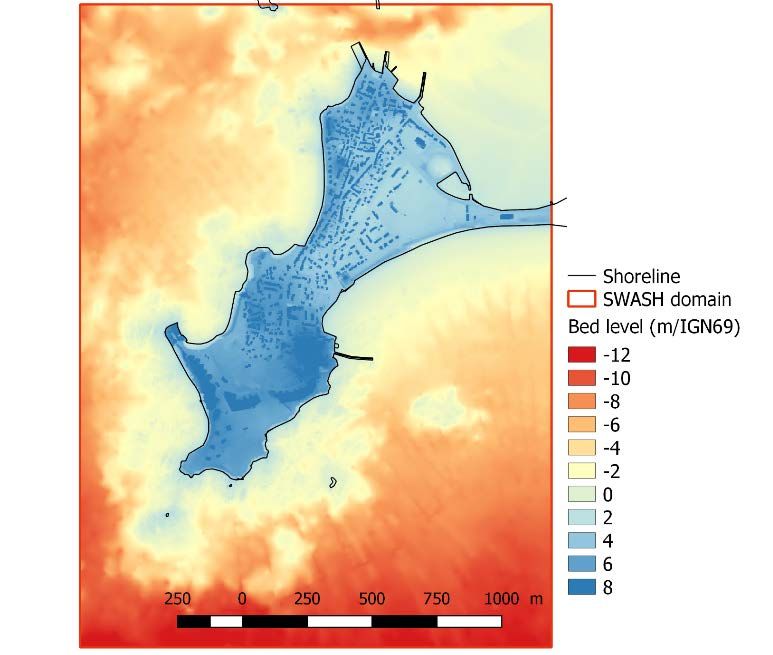
THE HYDRO-METEOROLOGICAL DATABASE

Objectif : continuous time series                                             NMR+T+S

from 1900-2010                                                                 U,Dw

                                                                   Hs,Tp,Dp

Data sources

     Absolute mean sea level            -              BRGM      Rohmer & Le Cozannet (2018)
                             (NMR)
     Vertical ground motion           SONEL            LIENS     Santamaria-Gomez et al. (2017)

   + Quantile-quantile correction using the best hindcasts as reference
                                                                                                  7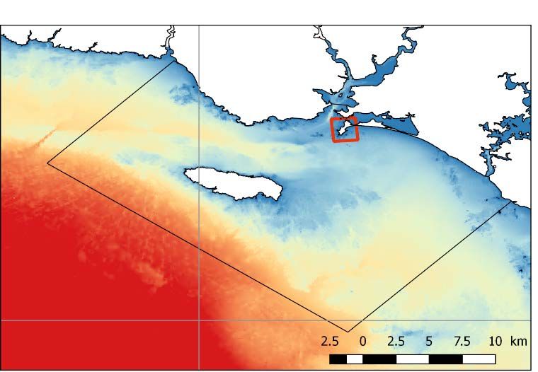
THE HYDRO-METEOROLOGICAL DATABASE

Objectif : continuous time series
from 1900-2010

                                    8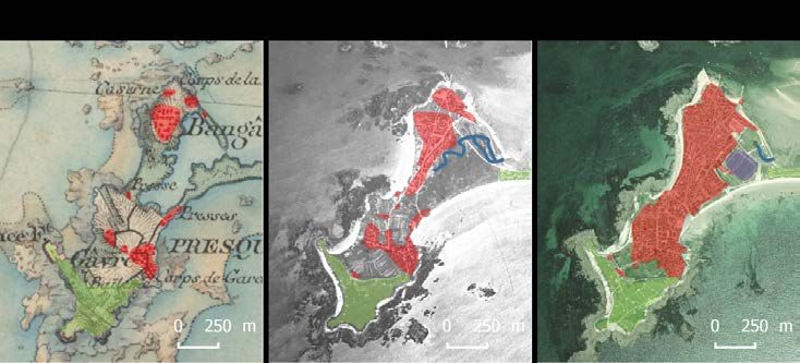
THE DAMAGE EVENT DATABASE

 • Based on:
     • Archives municipales de Gâvres, Archives
        départementales du Morbihan, Service
        Historique de la Marine, … through (Le
        Cornec et al., 2012).
     • Presse contemporaine aux évènements
 • 48 damage events
 • Flood event classification (F) : 0 (no flood), 1
   (moderate flood), 2 (massive flood).

                                                      9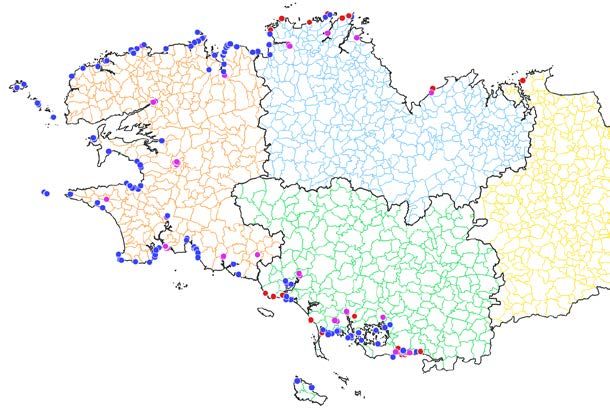
THE DAMAGE EVENT DATABASE
• Based on:
• Archives municipales de Gâvres, Archives
départementales du Morbihan, Service
Historique de la Marine, … through (Le
Cornec et al., 2012).
• Presse contemporaine aux évènements
• 48 damage events
• Flood event classification (F) : 0 (no flood), 1
(moderate flood), 2 (massive flood).
• Confidence indicator (C) : 1 (moderate), 2 (high)
9 flood events
10THE DAMAGE EVENT DATABASE
« update » using the Vol indicator (model)
Only for events of moderate confidence (C1=1)
Vol=0
11THE DAMAGE EVENT DATABASE
« update » using the Vol indicator (model)
Only for events of moderate confidence (C1=1)
Vol=max(Vol)
12THE DAMAGE EVENT DATABASE
« update » using the Vol indicator (model)
Only for events of moderate confidence (C1=1)
9 flood events :
• 4 : moderate overtopping or moderate
flood (2001, 2004, 2009, 2010)
• 5 : significant flood (1904, 1924, 1978,
2001, 2008), with 4 with high confidence
the 9 flood events: a low bound of what really
happened between 1900 and 2010.
13KEY RESULTS: Critical conditions for flooding
Values below which no flood events
occurred:
Vent
• Water level (NMR+tide+surge): 2.76 m IGN69
• Hs: 2.6 m
• Tp: 9 s
• Wind speed: 4 m/s
Vagues
Flood
F=0 (no flood)
F=1 (moderate flood)
F=2 (massive flood)
Confidence
C=1 (moderate)
/ IGN69
C=2 (high)
14KEY RESULTS: Critical conditions for flooding
Values below which no flood events
occurred:
Vent
• Water level (NMR+tide+surge): 2.76 m IGN69
• Hs: 2.6 m
• Tp: 9 s
• Wind speed: 4 m/s
Values below which no significant flood
event occured:
• Water level (NMR+tide+surge): 2.98 m IGN69
• Hs: 3.5 m
• Tp: 11 s
• Wind speed: 7 m/s
Vagues
Flood
F=0 (no flood)
F=1 (moderate flood)
F=2 (massive flood)
Confidence
C=1 (moderate)
/ IGN69
C=2 (high)
15KEY RESULTS: Probability of occurrence of the critical hydro-
meteorological conditions
Still Water Level (ξ=MSL+Tide+Surge) & Wave conditions: the main drivers
Joint exceedance return period (ξ/MSL =Tide + Surge, wave height)
Adapted from idier et al. (2020)
16KEY RESULTS: Probability of occurrence of the critical hydro-
meteorological conditions
Still Water Level (ξ=MSL+Tide+Surge) & Wave conditions: the main drivers
Joint exceedance return period (ξ/MSL =Tide + Surge, wave height)
MSL↑
ξ(9/1/1924)
ξ/MSL (1924)
ξ/MSL
MSL↑
MSL(2017)
MSL(1924)
Adapted from idier et al. (2020)
17KEY RESULTS: Most historical bi-variate events become annual before
2100 for rcp8.5
Joint exceedance return period (ξ/MSL, Hs) as a function of Mean Sea-Level
RP
Sea-Level Rise (m)
2017 ~ 2100 median value for
Adapted from idier et al. (2020)
RCP8.5 (AR5, SROCC)
18CONCLUSIONS
• Characterization of past flood events over 110 years
• A pragmatic approach to estimate the hydro-meteorological conditions
• 9 flood events, including 5 major flooding
• Sea-level rise has already (and will) significantly altered the hydrodynamic
forcing in Gâvres
Source: IPCC, 2019: Technical Summary
19A une échelle plus régionale : « BD tempêtes » Bretagne
• Cadre : travaux BRGM pour la DREAL
• Aujourd’hui en base :
o 6012 points
o dont 4652 impacts directs
(Erosion, Submersion, …)
o Entre le XIème siècle et
aujourd’hui
• Point contact : Sylvestre Leroy
(s.leroy@brgm.fr)
Exemples extraction « submersion »
Impacts directs
Recensés
Submersion
Submersion en lien
avec de l’érosion
Submersion en lien
avec une crue
09/01/1924 10/03/2008 Hiver 2013-2014
20DISCUSSION
Gâvres has changed a lot. Maximal inland water depth, simulated for
the 10/03/2008 hydro-meteorological
conditions (Johanna)
Fond : Photo IGN, 2013
Source: adapté de Idier et al. (2020)
Etat-major IGN IGN
h (m)
• Few “inhabitants” and assets one century ago
DEM 2008
Still possible to have missed one minor
flood event
Fond : Photo IGN, 2013
• Changes in coastal defences and topo-
bathymetry
Possible that past hydro-meteorological
conditions which led to major flood would
not lead to major flood today
DEM 2015
21DISCUSSION
Open questions
• Importance of knowing temporal evolution of the territory (& topo-bathy) … but hard to
access for “old” events, and even more for future evolution
• For territories which have changed a lot: caution needed in the way to use historical flood
information, depending on the objective (knowledge of past events; present-day hazard
assessment; …)
• On sites which exhibit a significant erosion (long-term, seasonal or inter-annual) but not
not necessarily floods, perhaps consider also “erosive” events to identify events which
could lead to future flood?
• Today's storm impact networks are our sources of tomorrow's historical information.
o See for instance: the BRGM networks (“Réseaux Tempête”) in Occitanie, Aquitaine,
PACA, Corse (and in other regions in a near future) capitalized in standardized
regional BRGM “BD tempête”’s.
THANK YOU for your attention
For more information:
• d.idier@brgm.fr
• Idier et al. (2020) Nat Hazards. https://doi.org/10.1007/s11069-020-03882-4
• Riscope project: https://perso.math.univ-toulouse.fr/riscope/
• « Réseaux Tempête » (example): https://www.brgm.fr/projet/reseau-tempetes-observatoire-cote-aquitaine
22You can also read