40'000 storm biographies: tracking hail swaths on radar data between 2002 and 2016
←
→
Page content transcription
If your browser does not render page correctly, please read the page content below

>40'000 storm biographies:
tracking hail swaths on radar data between 2002 and 2016

        L. Nisi1,2, A. Hering2, U. Germann2 and O. Martius1
        1 Universityof Bern, Oeschger Centre for Climate Change Research and Institute of
          Geography, Bern, Switzerland
        2 Federal Office of Climatology and Meteorology MeteoSwiss, Locarno-Monti, Switzerland

                                           18th April 2018
Outline

Part 1: hail in the Alps
• Storm tracks climatology                           et al.
• Diurnal cycle
• Lightning Jump

Part 2: satellite research activities @ MeteoSwiss
• New satellite rain rate retrieval
   using Artificial Neural Networks (ANN)
                                                     et al.
• COALITION-2 operational at MeteoSwiss

                                                              2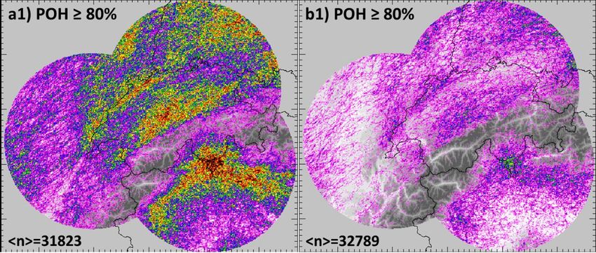
Research domain

                  ●   radar sites included in the analysis

                  ●   new radar sites (after 2014);
                      not included in the analysis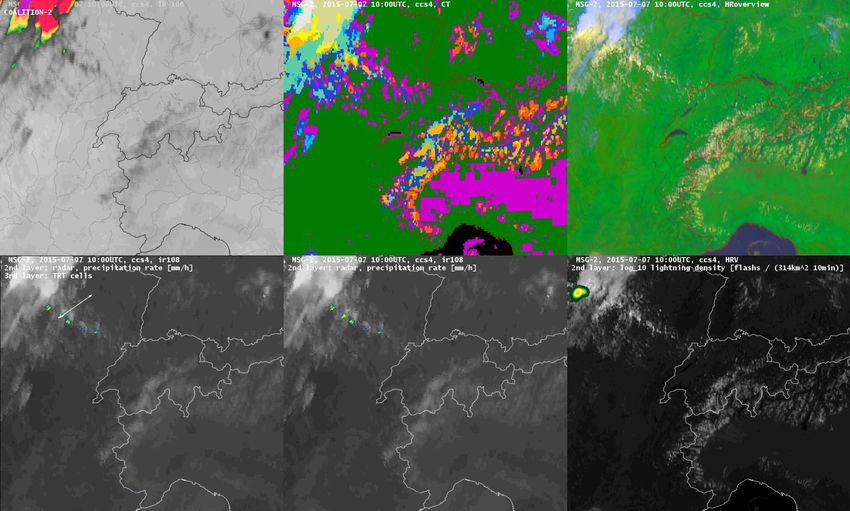
Algorithms

  •    POH (Foote et al., 2005 ; Waldvogel et al., 1979)
       (Probability Of Hail)
       → EchoTop 45dBz, freezing level
                                                               → HAIL PROBABILITY
       → operational in several Met.Services

  •    MESHS (Joe et al., 2004; Treloar, 1998)
       (Maximum Expected Severe Hail Size)                      → HAIL SIZE
       → EchoTop 50dBz, freezing level
       → operational: BoM, Canada, MeteoSwiss (..)

  •    TRT (Hering et al., 2004; Rotach et al., 2008)
                                                                → STORM TRACK
       (Thunderstorm Radar Tracking)
       →3D-radar parameters
       → operational: MeteoSwiss
Nisi et al. (2016). Spatial and temporal distribution of hailstorms in the Alpine region: a long-
term, high resolution, radar-based analysis. Q.J.R. Meteorol. Soc., 142: 1590–1604.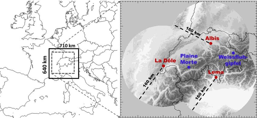
Definitions
Storm and hail swath tracking

    • Thunderstorm Radar Tracking algorithm (TRT)                                                      ‘object
                                                                                                       based’
    • 1 km2, 5min, APR-SEP 2002-2016
                                                                         Maximal Expected Size of
         Probability of Hail (0-100%)
                                                                               Hail (>2cm)
         23 JUL 2009                                                   23 JUL 2009

                                                    Bern                                               Bern

                                 Lake Geneva                                             Lake Geneva

0
          50 km                                                         50 km

    0         20       40   60                 80          100 %   2          3      4     5           6      cm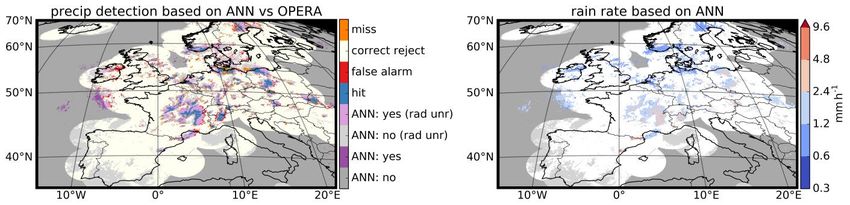
Trajectory climatology

                                                                                          ‘object
                                                                                          based’
            • Thunderstorm Radar Tracking algorithm (TRT)
            • 1 km2, 5min, APR-SEP 2002-2016

             → Hail storm (entire trajectory)       → Hail swath only frequency
                        frequency

Nisi et al. (2018). A 15‐year hail streak climatology for the Alpine region. (accepted QJRMS)
Trajectory lenght, duration, explosivity

light grey:
entire
storm path

dark grey:
hail swath
only

Diurnal cycle of hail storms in the Alps

                                                                  hail storm
                                                                  initiation

   → Alpine pumping and orographic triggering: during the day hail storm
     initiation and hail max are closer to the alpine main ridge.
Nisi et al. (in prep)
Diurnal cycle of hail storms in the Alps

              hail max (POH / MESHS)

                        storm
                        initiation
                        (radar)

Nisi et al. (in prep)
Diurnal cycle of hail storms in the Alps
2003
2009
2008
2006
2002,2004,
2005,2007,
2010-2016
→ 2006, 2008: greater fraction of airmass convection
→ 2003, 2009: diurnal cycle not present
Nisi et al. (in prep)Diurnal cycle of hail storms in the Alps
ERA-Interim
→ 2006, 2008: greater fraction of airmass convection
→ 2003, 2009: diurnal cycle not present
Nisi et al., (in prep)Lightning Jumps vs. hail storms (2013-2017)
(total lightning)
LJ before hail initiation (POH ≥ 80%, for
hail storms) or MaxEcho for ordinary LJ during entire storm life cycle:
storms:
0.9
0.9
0.8 single and multi LJ (≥ 1) single and multi LJ (≥ 1)
0.8
multi LJ (≥ 2) only multi LJ (≥ 2) only
0.7
0.7
0.6
frequency
0.6
frequency
0.5 58% (20 min) vs 42% 0.5
0.4
0.4
0.3
0.3
0.2
0.2
0.1
0.1
0
ordinary POH MESHS MESHS MESHS 0
POH MESHS MESHS MESHS
≥80% ≥2cm ≥4cm ≥6cm ordinary
≥80% ≥2cm ≥4cm ≥6cm
storms
number: (36211) (5724) (3874) (1370) (266)
• LJ algorithm: Schultz et al., 2009, modified (Lightningratemin: 30 flashes / 5 min, α = 2)
• LJ intensity: Wapler, 2017
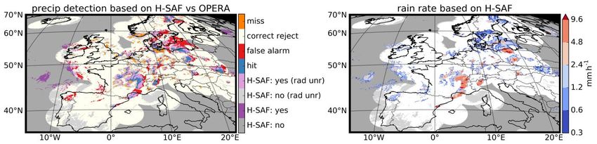
Nisi et al., (in prep)New satellite rain rate retrieval
using Artifical Neural Networks (ANN)
Input data
• Brightness temperature
• Brightness temperature differences
• NWC SAF products (CMa, CT, CTTH)
Reference data
quality checked
European OPERA radar composite
Study period
2017-05-16 00:00 – 2017-07-30 23:45
800 time slots for training,
400 for validation and 400 for testing
Methods
2 Multi-Layer Perceptron (MLP) ANNs
1st rain detection
2nd rain rate retrieval
both 2 hidden layers Probability of detection (POD), False alarm ratio (FAR), False alarm rate (FA),
Accuracy (ACC), Critical success index (CSI), Gilbert skill score (GSS), Heidke skill
score (HSS), Hanssen-Kuipers discriminant (HK) for the summer 2017 test set
(circles) and the single scene case study of 10 July 2017, 15:00UTC (as x) and 30
Beusch, et al. (in prep) June 2017 06:45UTC (crosses).Case study 10 July 2017 15:00 UTC
Odyssey
Radar
artificial neural
network (ANN)
HSAF
H03
Beusch, et al. (in prep)Thunderstorm detection
COALITION2
• Mandate of the National Weather Services to
issue warning of severe weather
• COALITION-2 supports thunderstorm warnings
by forecasters
• Monitoring and Nowcasting of intense
thunderstorm based on MSG/SEVIRI satellite
observations
• Early thunderstorm detection
(about 10 min before radar detection)
• Updated information every 5 min
• Spatial resolution 1 km x 1 km
(for Europe 3 km x 5 km)
Hamann et al, 2017 Retrieval by Elena Leonarduzzi / Ulrich HamannCOALITION-2 Swiss version
COALITION2 Cloud Type (NWCSAF) High Resolution Overview
• High spatial
resolution
(1 km x 1 km)
• Covers Switzerland
and surrounding
(same as radar)
• Optimal for
Thunderstorm
Nowcasting and
Warnings
• Used in combination
with Radar and
Lightning observation
• parallax
correction
TRT Cell Tracking Radar Rain Rate Lightning Density
Hamann et al, 2017References Beusch et al., 2017. Thunderstorm nowcasting by applying machine learning to a multi-sensor observation and NWP model data base. 9th European Conference on Severe Storms 2017, Pula, Croatia Beusch et al., (in prep). Satellite-based rainfall retrieval: from generalized linear models to machine learning techniques (in prep). Hamann et al., 2017. Nowcasting of thunderstorms and severe convection in Switzerland. 2nd European Nowcasting Conference 2017, Offenbach, Germany Nisi et al., 2016. Spatial and temporal distribution of hailstorms in the Alpine region: a long-term, high resolution, radar-based analysis. QJRMS, 142: 1590–1604. Nisi et al., 2018. A 15‐year hail streak climatology for the Alpine region. (accepted QJRMS)
You can also read