Modeling of long-term coastal morphodynamics of the Pomeranian Bight, southern Baltic Sea
←
→
Page content transcription
If your browser does not render page correctly, please read the page content below
The 12th German-Polish Seminar on Coastal Research
                       including
          6th International COPAF Workshop
                           Greifswald, 11/12th October, 2012

Modeling of long-term coastal morphodynamics of
   the Pomeranian Bight, southern Baltic Sea

Junjie Deng1, Wenyan Zhang2, Joanna Dudzinska-Nowak1, Pawel Terefenko1, Andrzej Giza1,
Jan Harff1, Ralf Schneider2, and Kazimierz Furmanczyk1

1 Faculty of Geosciences, University of Szczecin, Poland, Email junjie.deng@univ.szczecin.pl
2 Institute of Physics, University of Greifswald, Germany

                                         CoPaF ( www.copaf.pl )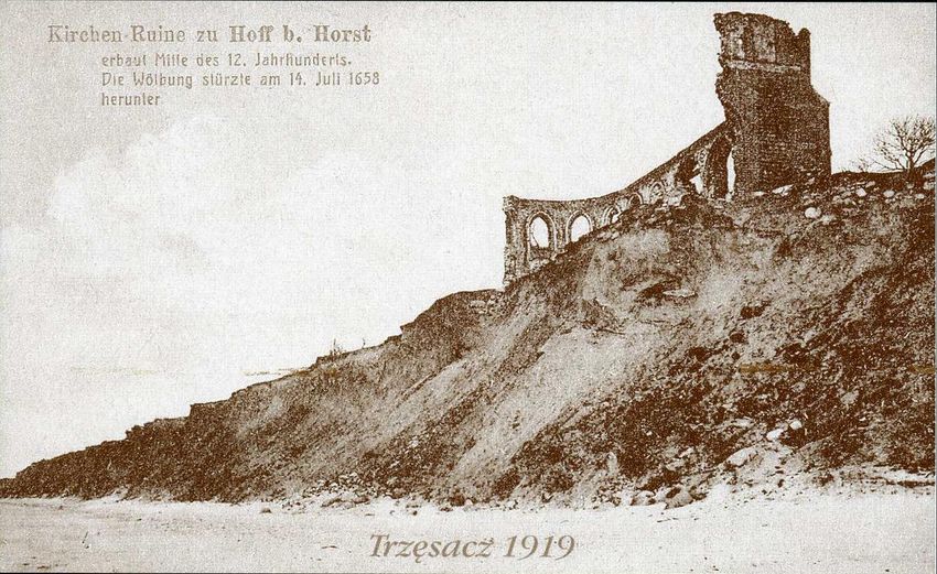
Outline
• Area of Investigation
• Method of reconstruction of Paleo-DEM at ca. 1900 AD:
     • Dynamic equilibrium shore model
     • Inverse modeling
• The comparison with BS-LTMM long term
  morphodynamic model that start with this
  reconstructed DEM.
• Discussion and Summary
• Prospects of the reconstruction of Paleo-DEM at ca.
  1500 AD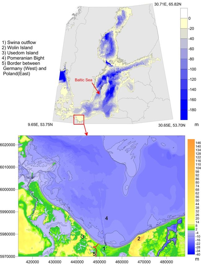
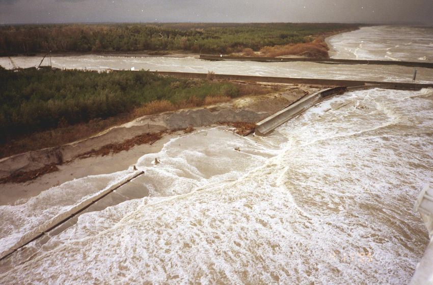
Coastal erosion during storm surge at Dziwnów on November 4, 1995

                                                      Photo: P. Domaradzki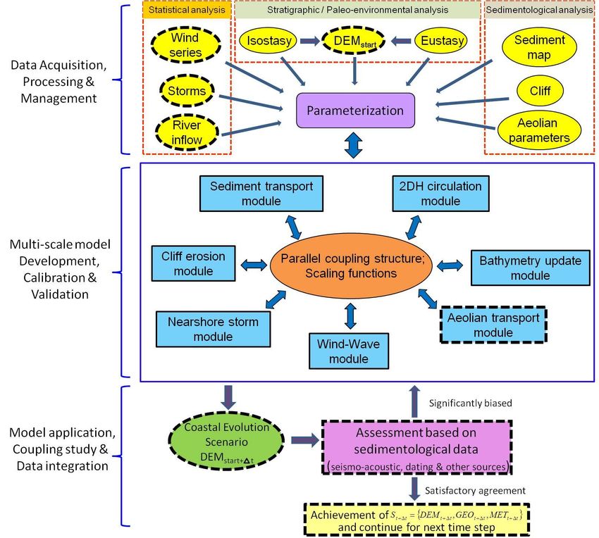
Area of Investigation               Bathymetry of Baltic Sea
                                    by Seifert et al. (2001)

• Sandy coast
      •   cliff and dune
• Tideless
• Wave-dominated
• Odra River (Leipe et al., 1998)
-   Water: 18 km3/yr
-   Sediment: 42.5 x10⁴ tons/yr
-   No sediments from river
    depositing at the coast
    (eg.Christiansen, 2002)

• Coastal driving forces:
-   Eustatic sea level change (1mm/yr)
     by Harff and Lüth (2007)
-   Vertical crustal movement
    (0 to - 0.5mm/yr)
     by Harff and Meyer (2011)
- Wind (wave, storm surge)

                                                         15m*15m Recent DEM (UTM 33N)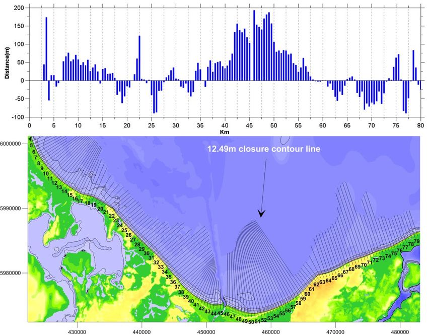
The purpose to develop new method
• Forward modeling: long term morphodynamic model ( BS-
  LTMM) (Zhang et al., 2010ab, 2011, 2012a)

                           Forward model (BS-LTMM)

                                 Parameterization     Prediction(projection)
                                 Validation
              DEM1900 AD                    DEM2000 AD             DEM2100 AD

                       Model
                                    Inverse model          Measured Data
      Iteration      parameter                                       Eustatic sea level
                                                                          change
DEM1900 AD                              Model       DEM2000 AD       Local neotetonic
                                                                        movement
                    Sediment
                  budget analysis                                    Historical map at
                                                                         1900 AD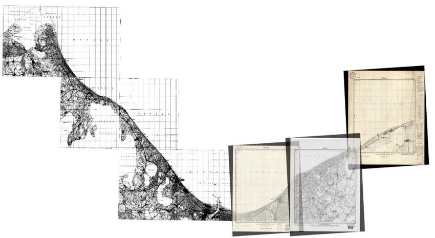
Dynamic equilibrium shore model
• Classic Bruun model (Bruun, 1964; 1988) for the retreating
  cliff coast by definition of Wolinsky and Murray (2009)
   • Submarine profile shape is invariant
   • There are no external sediment sources or sinks
   • Profile shifts with the same displacement of sea level rise and
     coastline retreat
• Dynamic equilibrium shore model
   • Submarine profile shape is variable
   • There are external sediment sources or sinks
   • Profile shifts with the same displacement of sea level rise and
     coastline retreat
• The submarine profile shape is approximated by exponential function presented by
  (Bodge,1992; Komar and Mcdougal, 1994; Romanczyk et al., 2005), as the limit of
  exponential decay might be related to limit of offshore decay of sediment movement,
  which is in contrast to the infinite depth of the power law function by Dean (1991)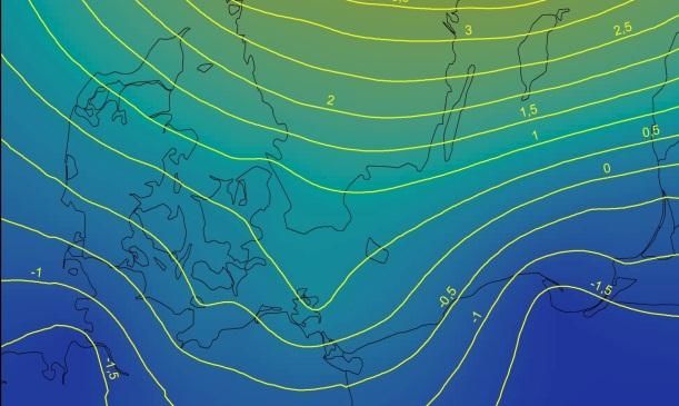
What’s Dynamic equilibrium shore model ?

                                      Where

                                      Offshore limit of
                                      exponential function

                                      b0 and b1 are
                                      Curvature parameter

                                  0
 For the whole retreating coast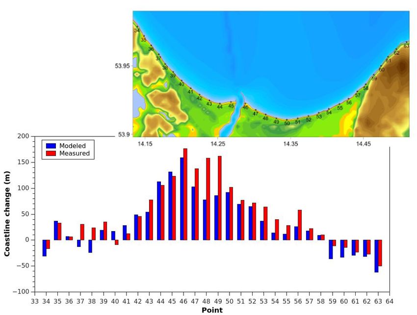
Unknown:                   Because b1 is unknown

           Assume: b1=b0

Known: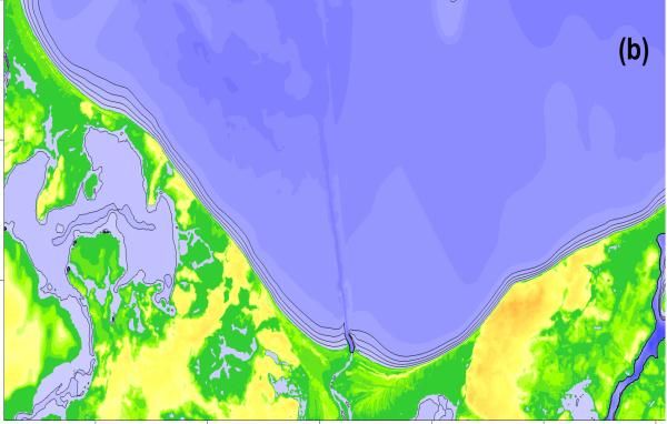
Numerical process for calculating b1

           Inverse modeling                  Const = 1.0

                         Const =
                                              b1= b0* const
                        Const - 0.1

                                         Dynamic equilibrium
                                            shore model
Input

        Vexternal             >       Bathymetrical mass volume
                                       ∑(Verosion-Vdeposition) internal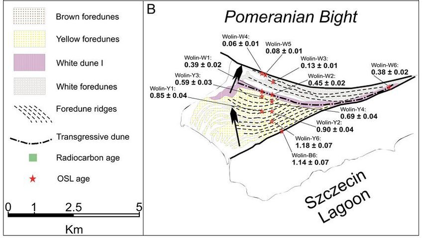
Historical coastline at ca. 1900 AD
(1 : 25 000 Messtischblatt map)

                             Recent coastline at ca. 2000 AD
                             From topographic map at the Usedom
                             Island , and high resolution profiles at
                             the Wolin island (Maritime Office in
                             Szczecin)
Coastline change(m)
Coastline change (c) for the last 100 years
Recent DEM (UTM33N) and cross shore base lines for the modelingSubaerial sediment mass volume (Vdune)subaerial, Vcliff )
Inverse procedure (Submarine sediment mass volume from b1 = 1.0 b0 to b1= 0.7*b0)
(Vdune)submarine, ∑(Verosion-Vdeposition) internalb1 = 0.7 b0 Paleo-DEM at 1900 AD b1 = b 0
Recent DEM at 2000 AD
• Forward modeling: long term morphodynamic model ( BS-LTMM)
  (Zhang et al., 2010ab,2011, 2012a)

         Wind, Sea level change and Glacial Isostatic Adjustment movement

                      Process-based model (BS-LTMM)

                        Parameterization
                        Validation
         DEM1900 AD                  Predicted DEM2000 AD
                                                      Coastline change
                                 Comparison in
                                                      Sediment erosion and deposition

          DEM1900 AD                 Measured DEM2000 AD

             Inverse model: Dynamic equilibrium shore model

             Sea level change and Neotectonic movements
BS-LTMM model input:
Paleo-DEM Geological Glacial Isostatic
Representative wind Eustatic curve
at ca. 1900 AD map AdjustmentBS-LTMM model input:
Paleo-DEM Geological Glacial Isostatic
Representative wind Eustatic curve
at ca. 1900 AD map Adjustment
Wind data from well validated coupled atmosphere and ocean model by Weisse et al, 2009BS-LTMM model input:
Paleo-DEM Geological Glacial Isostatic
Representative wind Eustatic curve
at ca. 1900 AD map Adjustment
Surface sediment map modified from Bobertz et al. (2006)BS-LTMM model input:
Paleo-DEM Geological Glacial Isostatic
Representative wind Eustatic curve
at ca. 1900 AD map Adjustment
Climatically controlled sea level rise, southern Baltic for the last 8.000 years
(rsl-curve Fischland after Lampe et al., 2007)BS-LTMM model input:
Paleo-DEM Geological Glacial Isostatic
Representative wind Eustatic curve
at ca. 1900 AD map Adjustment
(mm) Dudzinska-Nowak et al. (in prep.)Coastline change comparison between modeled and measured
(a) Difference between Measured DEM 2000 AD and
    reconstructed DEM at 1900 AD

                                                  Deposition

(b) Simulated bed level Changes by BS-LTMM From
1900 AD to 2000 AD

                                                  Erosion
Summary and Discussion
• This work shows that the reconstruction method based on the Dynamic
equilibrium shore model and inverse modeling technique results in a paleo-
DEM that serves as a sufficient base for the hindcast simulation of BS-LTMM
by the comparison
• in coastline change
• and sediment erosion and deposition.
• The inverse procedure proves that the paleo-profile shape along the cliff
coast is different from the recent one with a smaller curvature parameter.
• the sea floor abrasion take places further offshore to the depth deeper
then 11m, this coincides with the results by Schwarzer et al. (2003)
• The inverse modeling is an effective method to determine the unknown
parameters, when the variant profile shape is assumed.
• Despite the fact that the Dynamic equilibrium shore model is simplifying the
multi-scale process of coastal morphodynamics, it has the potential to be
used in coastal protection planning, for instance for balancing beach
nourishments.The prospects for the reconstruction of Paleo-
DEM at ca. 1500 AD of Swina gate
• Coastline reconstruction at ca. 1500 AD based on
• OSL dating from Reimann et al. (2011)
• High resolution (15m*15m) DEM of Swina gate area
Fig. 6 Maps showing the ages of the yellow and white dunes at Wolin spit. OSL ages are indicated in ka before 2008, and
radiocarbon ages are indicated in calibrated ka BP.The prospects for the reconstruction of Paleo-
DEM at ca. 1500 AD of Swina gate
• Coastline reconstruction at ca. 1500 AD
Reeve and Spivack (1994)The prospects for the reconstruction of Paleo- DEM at ca. 1500 AD of Swina gate • Coastline reconstruction at ca. 1500 AD based on • High resolution (15m*15m) DEM of Swina gate area
Acknowledgement
• Thanks to the CoPaF (www.copaf.pl) project funded
  by Ministry of Science and Higher Education in
  Poland for the research.
• Thanks to the co-workers in Szczecin University,
  Poland and Greifswald University, Germany
Model Description
(BS-LTMM)

(Zhang et al., 2010ab, 2011, 2012a)
Generalize Bruun model

                         Unknown:
                                    Because b1 is unknown

                                          Assume: b1=b0
               Known:
You can also read