South Coast Ports & Harbours - Southampton, Shoreham, Newhaven, Folkestone & Dover - Maritime Archaeology Trust
←
→
Page content transcription
If your browser does not render page correctly, please read the page content below
South Coast
Forgotten Wrecks           Ports &
       of the
 First World War         Harbours
                          Southampton,
                   Shoreham, Newhaven,
                     Folkestone & Dover

    2018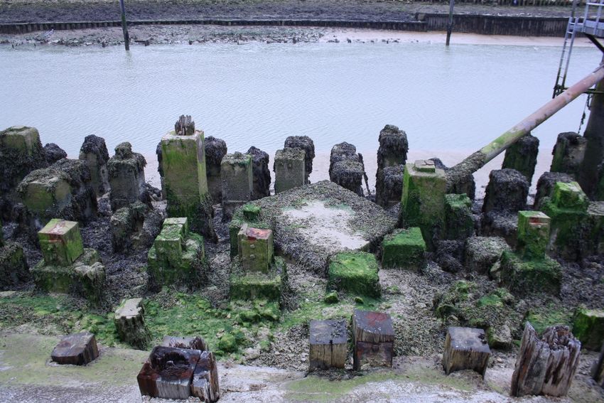
Forgotten Wrecks of the First World War       South Coast Ports in the First World War (2018)
Maritime Archaeology Trust

                               FORGOTTEN WRECKS
                             OF THE FIRST WORLD WAR

    Ports and Harbours on the South Coast during the
       First World War: Southampton, Shoreham,
            Newhaven, Folkestone and Dover

                                          1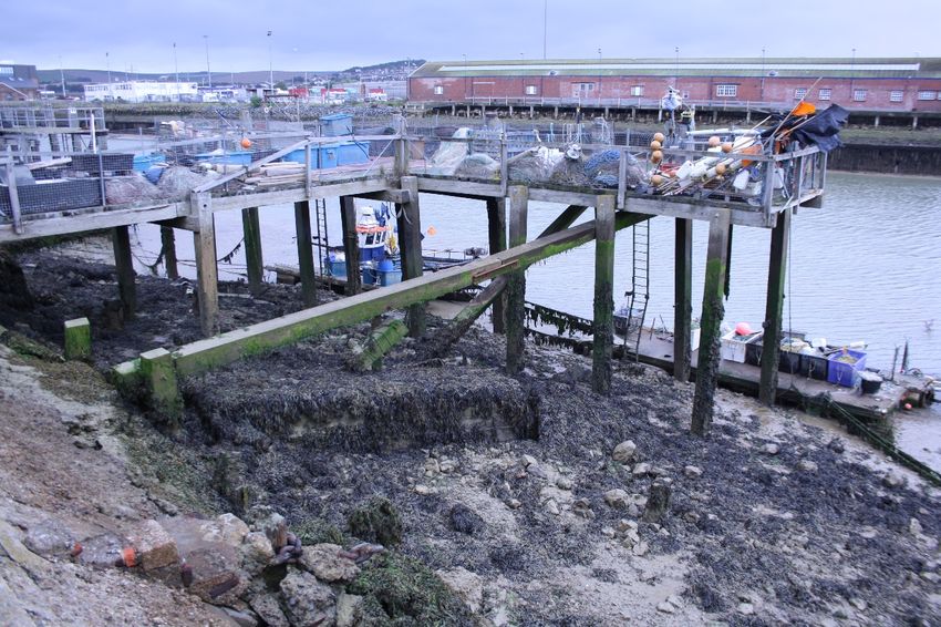
Forgotten Wrecks of the First World War                                                        South Coast Ports in the First World War (2018)
Maritime Archaeology Trust

Contents
   i. Acknowledgements .......................................................................................................................... 3
   ii. Copyright Statement ....................................................................................................................... 3
   iii. List of Figures.................................................................................................................................. 3
1. Project and Report Background .......................................................................................................... 5
2. The Role of Ports during the First World War..................................................................................... 6
3. Southampton ...................................................................................................................................... 7
   3.1 Southampton Port during World War One ................................................................................... 8
   3.2 Overview of Port Structures.......................................................................................................... 8
   3.3 Review of Surviving Remains from the First World War............................................................. 10
       3.3.1 Town Quay ........................................................................................................................... 10
       3.3.2 Buildings around Trafalgar Dock (Dry Dock no. 6) and White Star Dock ............................. 11
       3.3.3 Dock ‘Promontory’ ............................................................................................................... 11
       3.3.4 Empress Dock ....................................................................................................................... 12
       3.3.5 Frontage between entrance to Empress Dock and Dry Dock No.4 ..................................... 13
       3.3.6 Outer Dock and Dry Docks 1, 2 and 3 .................................................................................. 14
       3.3.7 Inner Dock ............................................................................................................................ 14
       3.3.8 Coal Barge Dock ................................................................................................................... 15
       3.3.9 Summary .............................................................................................................................. 15
4. Shoreham .......................................................................................................................................... 15
   4.1 Shoreham Port During the First World War ............................................................................... 15
   4.2 Overview of Port Structures........................................................................................................ 16
   4.3 Review of Surviving Remains from the First World War............................................................. 16
5. Newhaven ......................................................................................................................................... 17
   5.1 Newhaven during the First World War ....................................................................................... 17
       5.1.1 Supplying the Army .............................................................................................................. 17
       5.1.2 Defending the Docks ............................................................................................................ 19
       5.1.3 The Final Total and Final Cost .............................................................................................. 20
   5.2 Overview of Port Structures........................................................................................................ 21
   5.3 Photographic Survey of Surviving Remains from the First World War ....................................... 23
       5.3.1 Landing Stage Remains ........................................................................................................ 23
       5.3.2 Coaling Wharf ...................................................................................................................... 24
       5.3.3 Old Bridge ............................................................................................................................ 25
6. Folkestone ......................................................................................................................................... 26

                                                                            2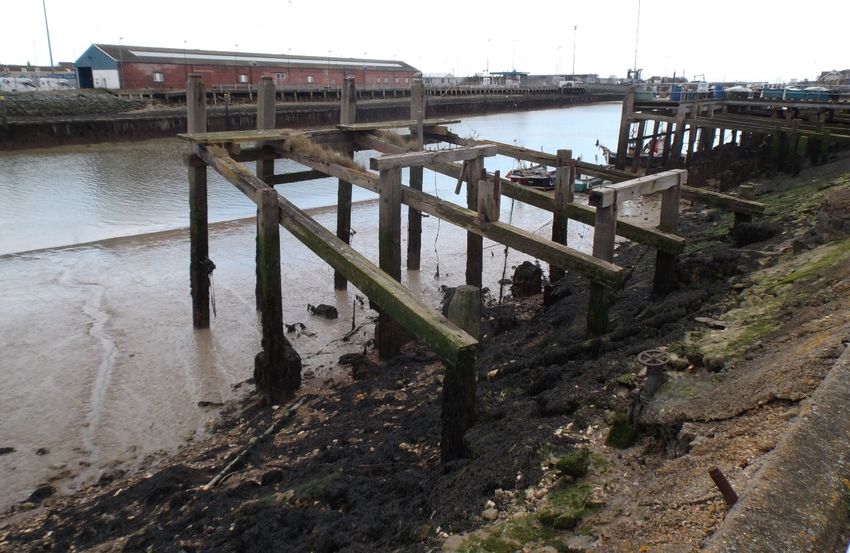
Forgotten Wrecks of the First World War                                                         South Coast Ports in the First World War (2018)
Maritime Archaeology Trust

   6.1 Folkestone during the First World War ...................................................................................... 26
   6.2 Overview of Port Structures........................................................................................................ 27
   6.3 Review of Surviving Remains from the First World War............................................................. 28
       6.3.1 Land to the south of the Inner and Outer Harbour ............................................................. 28
       6.3.2 Centre and north of the Harbour ......................................................................................... 28
7. Dover ................................................................................................................................................. 29
   7.1 Dover during the First World War .............................................................................................. 29
   7.2 Overview of Port Structures........................................................................................................ 29
   7.3 Review of Surviving Remains from the First World War............................................................. 32
       7.3.1 Admiralty Pier ...................................................................................................................... 32
       7.3.2 Admiralty Harbour Works, Tidal Harbour and Glanville Harbour ........................................ 32
       7.3.3 Wellington Dock ................................................................................................................... 33
       7.3.4 Admiralty Harbour Works at North of Harbour ................................................................... 34
8. Discussions and Conclusions ............................................................................................................. 34
9. References ........................................................................................................................................ 35

i. Acknowledgements
The Forgotten Wrecks of the First World War project was generously funded by the Heritage Lottery
Fund through their Heritage Grants Programme.

The Maritime Archaeology Trust would particularly like to thank Alastair Higton for his detailed desk
based research and assessment of the harbours using aerial photographs, Andrew Daw for his
research on the role of the ports in supplying logistics for the war and Richard Wyatt for his work on
images and contributions to research. We are also indebted to the volunteers who helped with field
survey at Newhaven Port.

Contributions to reporting by: Alastair Higton, Andrew Daw and Julie Satchell.

ii. Copyright Statement
This report has been produced by the MAT with the assistance of funding provided by the Heritage
Lottery Fund through their Heritage Grants Programme. Unless otherwise stated all images are
copyright of the MAT. If copyright is unknown, this is indicated in the caption.

Aerial photography of the ports from the Channel Coastal Observatory’s online resource was used.
This data contains public sector information licensed under the Open Government Licence v3.0.
Images from the CCO data within the report have been acknowledged as (CCO 2016).

iii. List of Figures
Figure 1: Location of south coast ports included within this study ........................................................ 6
Figure 2: Admiralty Plan of Southampton Dock ..................................................................................... 9
Figure 3: Southampton Eastern Docks (CCO 2016) ................................................................................ 9

                                                                             3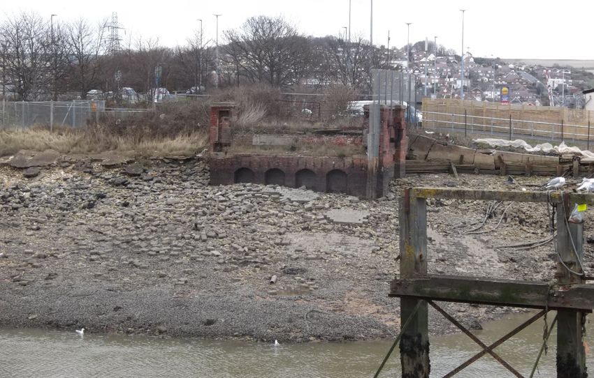
Forgotten Wrecks of the First World War                                                          South Coast Ports in the First World War (2018)
Maritime Archaeology Trust

Figure 4: Town Quay, Southampton 2016 (CCO) .................................................................................. 10
Figure 5: Buildings around Trafalgar Dock (Dry Dock no. 6) and White Star Dock (CCO) ..................... 11
Figure 6: Dock 'Promontory' in 2016 (CCO) .......................................................................................... 12
Figure 7: Empress Dock in 2016 (CCO) .................................................................................................. 13
Figure 8: Frontage between entrance to Empress Dock and Dry Dock No. 4 (CCO 2016) ................... 13
Figure 9: Outer Dock and Dry Docks 1, 2 and 3 (CCO 2016) ................................................................. 14
Figure 10: Inner Dock (CCO 2016) ......................................................................................................... 14
Figure 11: Coal Barge Dock (CCO 2016) ................................................................................................ 15
Figure 12: Detail of Shoreham Harbour, c.1912 (Ordnance Survey) .................................................... 16
Figure 13: Present day Shoreham Port (CCO 2016) .............................................................................. 16
Figure 14: Eastern end of Shoreham Harbour (CCO 2016) ................................................................... 17
Figure 15: Transports loading and drifters at Newhaven Port in the First World War (Courtesy of
Newhaven Museum) ............................................................................................................................. 18
Figure 16: Transports loading at Newhaven during the First World War (Courtesy of Newhaven
Museum) ............................................................................................................................................... 18
Figure 17: Transports loading in Newhaven during the First World War (Courtesy of Newhaven
Museum) ............................................................................................................................................... 19
Figure 18: Unveiling the Transport Memorial at Newhaven in 1920 (East Sussex News, 20th August
1920) ..................................................................................................................................................... 20
Figure 19: Comparison of map of Newhaven Port with modern aerial photograph (CCO 2016)......... 22
Figure 20: Newhaven breakwater and entrance to the port (CCO 2016)............................................. 23
Figure 21: Landing stage remains on the western side of Newhaven Port .......................................... 23
Figure 22: Landing stage with Coaling Wharf remains in the background ........................................... 24
Figure 23: Landing stage in the area of Newhaven Port used during the First World War, still in use
today ..................................................................................................................................................... 24
Figure 24: Piles at the former Coaling Wharf, Newhaven .................................................................... 25
Figure 25: Remains of old bridge over the River Ouse, eastern side .................................................... 25
Figure 26: Folkestone Harbour, March 1919 (The National Archives) ................................................. 27
Figure 27: Modern day Folkestone Harbour (CCO 2016) ..................................................................... 27
Figure 28: Land to the south of the inner and outer Harbour (CCO 2016) ........................................... 28
Figure 29: The main harbour and area to the north (CCO 2016).......................................................... 28
Figure 30: Dover Harbour Plan, Admiralty, October 1918 (UKHO)....................................................... 30
Figure 31: Detailed view of Tidal and Inner Harbours from Admiralty Dover Harbour Plan 1918 ....... 30
Figure 32: Detail of Dover Commercial Harbour from Admiralty Dover Harbour Plan 1918 ............... 31
Figure 33: Detail of Admiralty Harbour works from Plan of 1918 ........................................................ 31
Figure 34: Dover Harbour today from aerial photographs (CCO 2016) ................................................ 31
Figure 35: Admiralty Pier, Dover, from aerial photographs (CCO 2016) .............................................. 32
Figure 36: Admiralty Harbour Works, Tidal Harbour and Glanville Harbour (CCO 2016) .................... 33
Figure 37: Wellington Dock, Dover (CCO 2016) .................................................................................... 33
Figure 38: Admiralty Harbour Works, North Dover Harbour (CCO 2016) ............................................ 34

                                                                              4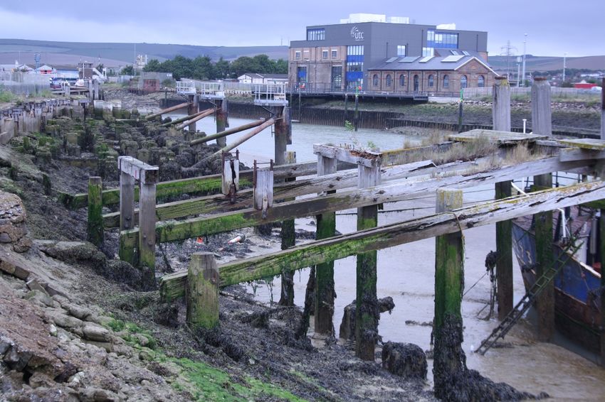
Forgotten Wrecks of the First World War                        South Coast Ports in the First World War (2018)
Maritime Archaeology Trust

1. Project and Report Background
Forgotten Wrecks of the First World War is a Heritage Lottery Funded project dedicated to raising the
profile of a currently under-represented aspect of the First World War. While attention is often
focused on the Western Front and major naval battles like Jutland, historic remains from the war lie,
largely forgotten, in and around our seas, rivers and estuaries.

With over 1,100 wartime wrecks and dozens of coastal sites along England’s south coast alone, the
conflict has left a rich heritage legacy and many associated stories of bravery and sacrifice. The
underwater memorials represent the vestiges of a vital, yet little known, struggle that took place on a
daily basis, just off our shores. The study and promotion of these archaeological sites presents a
unique opportunity to better interpret them and improve physical and virtual access.

The project focuses on underwater and coastal sites from the Isle of Thanet in Kent, to beyond the
Isles of Scilly, and over half way into the English Channel. The sites include merchant and naval ships,
passenger, troop and hospital ships, U-boats, ports, wharfs, buildings and foreshore hulks. These sites,
under water and on the foreshore, have been degrading and deteriorating due to natural and human
processes for approximately 100 years and, as a result, are extremely fragile. In many cases, this
project represents a final opportunity to record what remains on the seabed and foreshore before it
is lost forever.

The project aimed to characterise the nature and extent of the maritime First World War
archaeological resource surviving on the south coast’s seabed and around the coast. This will enable
an understanding of the record of maritime activity created during the conflict and provide a window
onto some of the surviving sites. While it was not be possible to visit and record every site dating to
the First World War along the south coast of England, a representative sample of sites have been
selected for more detailed study, analysis and interpretation.

With particular regard to coastal, rather than fully submerged archaeological remains, it has been
noted in wider commentaries on England’s coastal heritage (Murphy, 2014: 94) that there are
relatively few surviving sites because of subsequent reuse and/or destruction during or following the
Second World War. As a result, from the perspective of identifying coastal research priorities an
emphasis has been placed (Murphy, 2014: 119) on the need to differentiate First World War sites from
those of the Second World War. With all of this in mind, the following report addresses some of the
key south coast ports in use during the First World War for supplying and supporting activity on the
Front – Southampton, Shoreham, Newhaven, Folkestone and Dover (Figure 1). Their position in the
south east of England made them strategically placed for cross channel supply roles.

This report presents a brief historical background to the ports during the war and the potential for
surviving physical remains from this date as determined from the comparison of historical maps and
charts with modern aerial photography. This work was contributed to by volunteers; Alastair Higton
reviewed online aerial photography and researched documents and publications in The National
Archives, libraries and online to assess potential survival of remains while Andrew Daw undertook
extended research on the historical background to the ports and their role in supplying the front.
Research on the physical form of the ports has used maps and charts of a date as close to the war as
possible. This research was used to help target a field visit to Newhaven port, the results of which are
included within this report.

There were many other ports active during the First World War within the study area, particularly the
large military ports of Portsmouth, Devonport and Portland (for more detail see separate Forgotten
Wrecks report on research and survey at Portland), Richborough port built specifically for the war
effort, and other ports playing a role through building and repair of vessels, hosting patrols, mine

                                                   5
Forgotten Wrecks of the First World War                                   South Coast Ports in the First World War (2018)
Maritime Archaeology Trust

related craft or seaplane bases (for more detail see: First World War Seaplane Stations of the South
Coast of England
http://forgottenwrecks.maritimearchaeologytrust.org/uploads/images/Articles/Site%20Reports/FW
FWW_Seaplane_Stations_Report_2018.pdf), and maintaining the vital shipping of goods in the
general support of the country. While these ports are not featured within this report, their role is no
less significant and there is much potential for further research and study at these sites.

                           Figure 1: Location of south coast ports included within this study

2. The Role of Ports during the First World War
A key component in any military capability is logistics; support to the personnel engaged, the
equipment used and the replenishment of stores. During the First World War, there were limited
numbers of motor vehicles, an embryonic road network, and air transport was novel and unreliable,
this meant that logistics was the domain of the railway networks, ports and harbours. For the British
Expeditionary Forces (BEF), there existed the added complication of the English Channel, which
required a sea passage for any deployment or provision of support.

The combination of maritime and railway transportation systems existed on both sides of the Channel.
Stores and personnel travelled between factory and barrack to warehouse and front line via train,
canal barge, ferry or ship and then back to trains and barges. Returning soldiers, the wounded and
refugees traversed the route in reverse utilising the same infrastructure and facilities.

Whitmore (2018) highlights that “Maintaining these huge forces in the field - up to 2 million men were
serving on the Western Front - required vast amounts of supplies. Every bullet, blanket, bandage,
artillery battery or tin of bully beef had to be manufactured and transported where and when it was
required. By 1918 each Division of about 12,000 men needed about 1,000 tons of supplies every day
- equivalent to two supply trains each of 50 wagons. When an offensive was being planned, even larger
quantities of material had to be concentrated in preparation for the operations that might last for
months”. Transport on mainland Europe including operational inputs was also facilitated by a huge
number of horses and mules together with their foodstuff, also requiring maritime transport.

                                                           6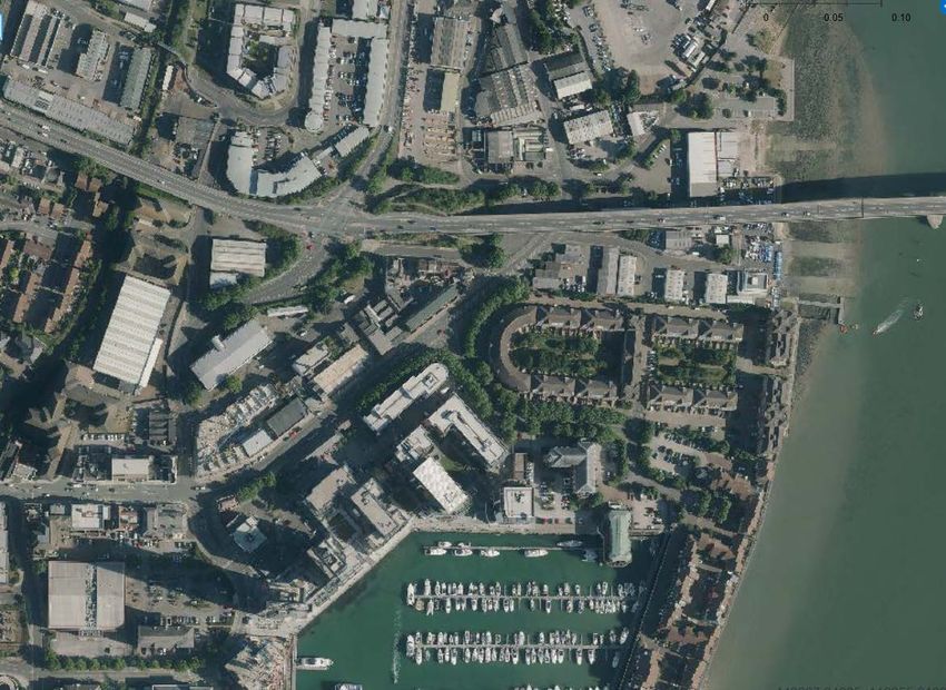
Forgotten Wrecks of the First World War                            South Coast Ports in the First World War (2018)
Maritime Archaeology Trust

The key points of departure for men and supplies from the UK were the Channel ports, often facilities
were both extended and developed from scratch at convenient locations along the coast. The primary
ports and their main roles were: Southampton, Folkestone, Dublin, Glasgow, Queenstown, Belfast,
and Jersey: troops and horses; Newhaven: stores; Liverpool: mechanical transport and frozen meat;
Avonmouth: mechanical transport and petrol; London: stevedores; Devonport: Siege Brigade; Dover:
Naval Brigade and troops. Portsmouth was used for ship building, repairs and refit, as were a number
of smaller ports.

A major harbour was constructed at Richborough whose purpose was to provide the B.E.F. with its
heavy equipment - tanks, guns, railway locomotives, ammunition, horses and fuel. Here, the first use
of specially designed sea-going Roll On / Roll Off ferries began in 1918, this complemented and
extended the existing barge services (which continued throughout the war).

Ports west of Southampton also contributed to the transport and deployment of men and material
but due to longer journey times they were not as extensively used. As an example, Plymouth/
Devonport became a major landing port for US troops deployed from the continental US prior to
embarking for France.

Volumes of Shipping During Six Weeks of 1914
Hurd (1924) gives a detailed account of the scale of sea transport required from the numbers recorded
as embarking at English and Irish ports over a six week period between August 9th and September
21st – 1914. During this six week period, a minimum of 93,364 tons of ammunition, stores, food,
forage, petrol, vehicles, etc., were carried in addition to personnel and horses. Numbers of personnel
and horses included:

                  Port               Officers    Other Ranks         Horses            Nurses and
                                                                                        Civilians
         Southampton              5,028         171,708         51,434              1,389
         Newhaven                 66            409             -                   9
         Avonmouth                58            4,547           -                   -
         Liverpool                16            1,741           -                   -
         Devonport                30            844             421                 -
         Belfast, Dublin &        826           25,921          10,184              -
         Queenstown
         Totals                   6,024         205,040         62,039              1,398

3. Southampton
The Port of Southampton has been an important harbour since Roman times and has played a
significant role in Britain’s military history for centuries. It has had a role in naval shipbuilding and has
been a departure point for several military expeditions including for Henry V’s Agincourt campaign,
the Crimean War, Boer War and both World Wars (Eddleston 2014:1). Southampton also has the
dubious honour of being the port of sailing for the Titanic. Southampton’s docks had been expanded
significantly in the late nineteenth and early twentieth centuries and were owned by the London &
South Western Railway at the time of the First World War.

The modern Port annually handles 1.7 million cruise passengers, 820,000 vehicles (freight and
transportation), and 14 million tonnes of cargo. As well as cruise and cross-Solent ferry services,
Southampton is also the UK’s second largest container terminal, is home to a five hectare bulk
terminal, an export grain-silo terminal, specialist fruit-landing facilities and has a crude oil terminal
(Associated British Ports).

                                                     7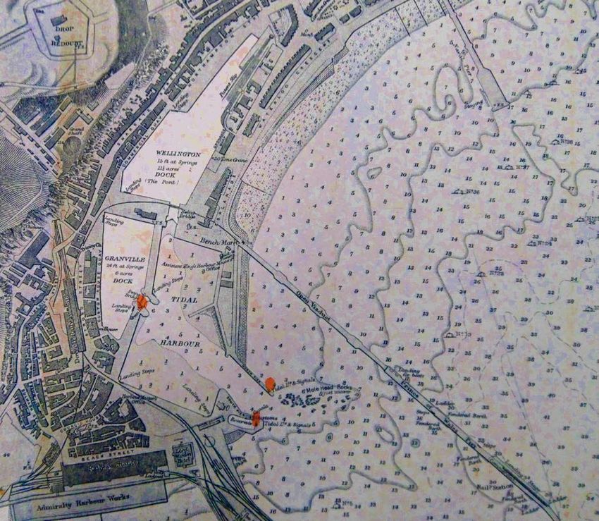
Forgotten Wrecks of the First World War                        South Coast Ports in the First World War (2018)
Maritime Archaeology Trust

The Eastern Docks cover over 60 acres and provide nearly 3 miles of quayside. Most of Southampton’s
traffic passed through here until 1934 when the Western Docks opened. As the Eastern docks were
the main facilities during the First World War research has focused on this area of the Port.

3.1 Southampton Port during World War One
In order to ferry men and materials to the Western Front and other theatres of war, Southampton
docks were taken over by the Government in August 1914 and in line with pre-war planning became
the No.1 Military Embarkation Port. The Port was primarily used to transport troops and horses.

Traffic was not one way: many war casualties, prisoners of war, refugees and on-leave servicemen
passed through Southampton. For example, during the July 1916 Somme Offensive Dover and
Southampton shared 118,496 casualty arrivals who were distributed to hospitals by train. At Netley
on the north-east shore of Southampton Water a Crimean War-era hospital was used, with significant
additional capacity provided by tents and a Red Cross hutted hospital at the rear of the site (Fairman,
1984:7). Many refugees and Imperial troops also disembarked at Southampton (BBC World War One
at Home).

Over 8 million soldiers, 386, 194 horses and mules, 15,000 artillery pieces and 180,000 vehicles passed
through Southampton during the War. In the first six weeks alone, 176,736 officers and men, 51,434
horses and 1389 civilians and nurses war transported to France (Hurd 1924). Good railway connections
made the port accessible from many areas of England, on the 22 August 1914, 73 BEF trains passed
through Southampton on their way to the docks.

At the peak of mobilisation up to eight troop trains were arriving at the docks every hour and up to 18
ships a day sailed across the Channel. At the same time, Imperial garrisons were arriving from places
like India and Egypt to join the fighting, and wounded soldiers and refugees poured in from the start
of the war (BBC First World War at Home).

Conventional ships were loaded with all sorts of heavy and bulky war material and then unloaded after
the comparatively short journey by sea. Roll-on roll-off train ferries were seen as a way to speed up
loading and unloading and were designed to be used from the new Military Port of Richborough in
Kent but started service between Southampton and Dieppe as Richborough was not complete.

In 1919 the Embarkation Commandant of ‘Port Number One’, Brigadier General Alfred Balfour,
thanked Southampton for its “magnificent service” to the nation. The only memorial to that service is
a small plaque on Admiralty House near Dock Gate 4.

3.2 Overview of Port Structures
Figure 2 shows a detail view of an Admiralty Plan of Southampton Docks held within the United
Kingdom Hydrographic Office collection. It was originally published on 19 June 1914 however this
version is dated 16 June 1922 and incorporates changes made to the docks during and immediately
after the war. The plan does however state it is created from a London and South Western Railway
Company plan made in 1919, although the soundings are from 1921. Figure 3 shows the Eastern Docks
as they are today.

                                                  8
Forgotten Wrecks of the First World War                                South Coast Ports in the First World War (2018)
Maritime Archaeology Trust

                                    Figure 2: Admiralty Plan of Southampton Dock

                                   Figure 3: Southampton Eastern Docks (CCO 2016)

                                                         9
Forgotten Wrecks of the First World War South Coast Ports in the First World War (2018)
Maritime Archaeology Trust
3.3 Review of Surviving Remains from the First World War
High resolution modern aerial imaging available from the Channel Coastal Observatory was used to
review the areas of the docks utilised during the First World War with the following presented below:
• Town quay
• Buildings around Trafalgar Dock (Dry Dock no. 6) and White Star Dock
• Dock ‘promontory’
• Empress Dock
• Frontage between entrance to Empress Dock and Dry Dock No.4
• Outer Dock and Dry Docks 1, 2 and 3
• Inner Dock
• Coal Barge Dock
3.3.1 Town Quay
Comparing the modern image of Town Quay (Figure 4) to the 1922 plan shows that the Royal Pier
itself is derelict and in poor condition with parts of it missing and the Pavilion no longer exists. The
1922 plan shows no other buildings there at the time. Red Funnel Ferries now occupy the berthing
between the Royal Pier and Town Quay. The 1922 plans show no buildings in this area.
The width of Town Quay appears to have been widened and there are modern building situated on
the eastern side of the quay, with car parking occupying the far end of the quay. There do not appear
to be any remains of specific First World War buildings surviving, and no evidence of remaining
railway/trackways remain from the 1922 plans on Town Quay. The Royal Pier and Harbour House at
the head of Town Quay are both Listed Buildings at Grade II.
Figure 4: Town Quay, Southampton 2016 (CCO)
10Forgotten Wrecks of the First World War South Coast Ports in the First World War (2018)
Maritime Archaeology Trust
3.3.2 Buildings around Trafalgar Dock (Dry Dock no. 6) and White Star Dock
All buildings and railway/trackway around the Trafalgar Dock shown on the 1922 plans, including the
Harland and Wolfe Works, no longer exist (Figure 5). The dock itself, although a Listed Building (Grade
II), has been partially filled in and claimed for car parking, however, the footprint of the dock is visible
and elements of the lock may remain. Also, the waterfront on the western edge of the dock is
undeveloped so may retain some wartime features.
The Post and Telephone Office and other buildings on Platform Road and Canute Road do remain, but
not the Customs House which has been replaced with a 1960s-70s office block. The cargo and
passenger sheds serving the White Star Dock have been replaced on the western side, by the modern
Ocean Cruise Terminal. Railway/ trackway, or imprints of it survive on either side of the dock, and as
there are no new buildings on the eastern side of the dock First World War material may survive.
Figure 5: Buildings around Trafalgar Dock (Dry Dock no. 6) and White Star Dock (CCO)
3.3.3 Dock ‘Promontory’
This area is now primarily used for disembarking imported motor vehicles, and on the south eastern
tip is a grain terminal. It appears that every building from the 1922 plan is now demolished (Figure 6).
Clarkson Port Services occupy a large building on the south western side of the promontory however
its footprint does not match the 1922 plans and images of the building suggest a much more recent
construction.
Railway/trackway, or its imprint, remains around the waterfront of much of the promontory. The
Timber Storage building has been replaced with multi-storey car parks for imported vehicles and the
centre of the promontory is largely used for this purpose. The Prince of Wales Dock has been
completely filled in and is now also car storage.
11Forgotten Wrecks of the First World War South Coast Ports in the First World War (2018)
Maritime Archaeology Trust
Figure 6: Dock 'Promontory' in 2016 (CCO)
3.3.4 Empress Dock
No buildings from the 1922 plan remain. Passenger and cargo sheds have given way to a lorry park,
sundry buildings and sheds and storage of materials. There may be some traces left of the passenger
and cargo sheds, but a visual survey on the ground would be required to confirm this. On the northern
waterfront, stretching back to cover marshalling yards between the Empress and Inner Docks is the
National Oceanography Centre (Figure 7).
12Forgotten Wrecks of the First World War South Coast Ports in the First World War (2018)
Maritime Archaeology Trust
Figure 7: Empress Dock in 2016 (CCO)
3.3.5 Frontage between entrance to Empress Dock and Dry Dock No.4
More storage for vehicle imports covers this site: a multi-storey car park and tarmac standing (Figure
8). The passenger and cargo sheds have been demolished. Railway/trackway, or their imprints, are
present at the tip of this area but they are more abundant than shown on the 1922 plans so are likely
to be a later development. At this ‘tip’ there is also some undeveloped land which could still provide
evidence of the cargo shed shown on the 1922 plans. Dry Dock number 4 has been filled in, and is now
residential housing.
Figure 8: Frontage between entrance to Empress Dock and Dry Dock No. 4 (CCO 2016)
13Forgotten Wrecks of the First World War South Coast Ports in the First World War (2018)
Maritime Archaeology Trust
3.3.6 Outer Dock and Dry Docks 1, 2 and 3
As with Dry Dock 4, these docks have also been reclaimed and repurposed for residential housing
(Figure 9). The Outer Dock is now a marina with mixed waterfront development. Whilst a small amount
of railway/trackway evidence is visible on the northern edge of the marina, otherwise is seems that
nothing from the 1922 plans remain other than the overall footprint of the dock. The walls of ‘Outer
Dock’ or Princess Alexandra Dock are Listed Buildings at Grade II.
Figure 9: Outer Dock and Dry Docks 1, 2 and 3 (CCO 2016)
3.3.7 Inner Dock
The Inner Dock no longer exists, having been entirely reclaimed. The sheds, warehouses and
supporting infrastructure have also disappeared. The site is largely used for car parking and light
industrial buildings (Figure 10).
Figure 10: Inner Dock (CCO 2016)
14Forgotten Wrecks of the First World War South Coast Ports in the First World War (2018)
Maritime Archaeology Trust
3.3.8 Coal Barge Dock
The smaller Coal Barge Dock has been removed along with the outer quay. The large dock has been
reclaimed for residential housing. Structures behind the dock are also residential housing, with some
light industrial and leisure units (Figure 11). There appear to be no visible remains from the 1922 plan.
Figure 11: Coal Barge Dock (CCO 2016)
3.3.9 Summary
Although much of the area of Southampton Port used during the First World War has undergone
significant changes, there are still opportunities to locate and record traces of the features and
buildings. Despite the massive volumes of troops that passed through Southampton, the physical
evidence of the waterside facilities that made this happen is still relatively little known.
4. Shoreham
Shoreham-by-Sea, like the other ports examined within this report, has a long history of human
settlement, evidenced by an Iron-Age hillfort in nearby Thundersbarrow and several Roman villas
(Norman 2017). Development of the port in the late 19th Century advanced the port significantly,
including a power station completed in 1897 and a gas works between the canal and the sea in 1870.
Coal for both was landed at nearby wharves (Shoreham Port).
The harbour is now used for commercial, maritime and leisure services and facilities including cargo
handling, storage, warehousing and fishing.
4.1 Shoreham Port During the First World War
Because Shoreham has a railhead, seaport and aerodrome it was considered strategically valuable for
movement of troops and heavy equipment. In 1914 a training camp was set up on Oxen Field to the
north of Mill Lane. Known as Mill Hill Camp it soon became overwhelmed by recruits. In the winter of
1914-15 tents were replaced with wooden billets and a second camp, for advanced training was set
up on Slonk Hill (ShorehamBySea).
15Forgotten Wrecks of the First World War South Coast Ports in the First World War (2018)
Maritime Archaeology Trust
Although specific troop numbers appear unavailable a large number of were posted to the camp for
training and then on to the Western Front. In total, five divisions were trained at these camps (Ibid).
In 1917 Shoreham was chosen as a site for one of 12 ‘Mystery Towers’ to be sunk into Varne Shoal
between Dungeness and Cap Gris Nez as siting points for anti-U-boat steel booms (Mystery Towers),
one of these, the ‘Nab Tower’ lies in the Eastern Solent approaches.
4.2 Overview of Port Structures
Maps contemporary to the First World War have not been found, however a map made just before
the war allows a limited assessment to be made, however it only shows the east arm of the harbour
and was also drawn before the beginning of the war, in 1912 (Ordnance Survey 1912) (Figure 12). This
map can be compared to the present day port using aerial photographs (Channel Coastal Observatory)
(Figure 13).
Figure 12: Detail of Shoreham Harbour, c.1912 (Ordnance Survey)
Figure 13: Present day Shoreham Port (CCO 2016)
4.3 Review of Surviving Remains from the First World War
The harbour has been extensively developed since the pre-war plan was drawn. Quaysides,
reclamation of land and embankments have altered the shape of the harbour. The tidal pond remains
but has been reshaped and is now in use for water sports (Figure 14). Further documentary and map
based research and a field visit would be required to help determine whether any stretches of
waterfront used during the War survive along with any infrastructure features.
16Forgotten Wrecks of the First World War South Coast Ports in the First World War (2018)
Maritime Archaeology Trust
Figure 14: Eastern end of Shoreham Harbour (CCO 2016)
5. Newhaven
Situated at the mouth of the River Ouse, Newhaven as a port became established after the
construction of a breakwater in the 1790s that reduced the movement of shingle which had impacted
the relationship of the river mouth with the coast. The opening of a railway line to Lewes in 1847 saw
investment in the port by the railway companies who established a wharf and a station, to provide
links directly to cross channel ferry and freight services.
Before the outbreak of the First World War, Newhaven was a key point in travel between Britain and
Europe. Billed as being the fastest way to reach France, Newhaven was the departure port for the
railway and steamship link from London to Dieppe. Passengers could ride the train down from London
before boarding one of the twice daily steamships that would cross the channel in just under three
hours. As a result, it was a key port for tourism and travel.
5.1 Newhaven during the First World War
During the First World War, the British Army in France needed to be regularly supplied with food,
ammunition and equipment in order to continue fighting. The port of Newhaven was at the forefront
of this supply effort (The First World War East Sussex). Newhaven was designated as the principal port
for the movement of men and material to the continent, and was taken over by the military authorities
and the ferries requisitioned for the duration of the war. Between 22 September 1916 and 2 December
1918, the port and town of Newhaven were designated a 'Special Military Area' under the 'Defence of
the Realm Regulations', and the Harbour station was closed to the public. The port and harbour
facilities, rail sidings and warehousing were greatly enlarged at this time and electric lighting installed
to allow for 24-hour operation. Some 17,000 crossings of the Channel took place and over six million
tons of supplies were carried to the French coastal ports. Eleven of the ships operating from Newhaven
were lost to enemy attacks from mines, submarines, aeroplanes or destroyers and about a hundred
of the seamen, who had become well known to the local townspeople, were killed. Many survivors of
the ships were brought back to the port (Port of Newhaven).
5.1.1 Supplying the Army
During 1914 and the early part of 1915, Britain was operating under a system often referred to as
‘Business as usual.’ Whilst the country may have been at war, the government was keen for the conflict
not to have too great an effect on the day to day running of the nation on the home front. The hope
was that the war would be swiftly won without overly disrupting trade and commerce.
17Forgotten Wrecks of the First World War South Coast Ports in the First World War (2018)
Maritime Archaeology Trust
Figure 15: Transports loading and drifters at Newhaven Port in the First World War (Courtesy of Newhaven Museum)
Figure 16: Transports loading at Newhaven during the First World War (Courtesy of Newhaven Museum)
The requisitioning of the port at Newhaven was at odds with this plan as it completely closed the area
to all commercial shipping. Many private shipping companies were keen for military supplies to be
moved from Newhaven to either Liverpool or Plymouth in order to reopen the East Sussex port to
them. The Divisional Naval Transport Office (DNTO) stationed at Newhaven blankly refused this
request. Instead of ‘Business as usual,’ the requisitioning of the port at Newhaven provided an early
18Forgotten Wrecks of the First World War South Coast Ports in the First World War (2018)
Maritime Archaeology Trust
insight into what would be known as ‘Total War‘ where the government would be empowered to
utilise any public or private industry to support the war effort for the duration of the conflict.
Following the decision to take control of Newhaven’s harbour, steamships were also requisitioned for
the transportation of supplies across the channel. These supplies included ammunition, clothing, food,
and horses. The return journeys from France would often include hospital ships returning wounded
men to Britain.
By October 1915, 45 transport vessels were engaged in the cross-channel supply effort. Around 6,000
tons of supplies were being delivered to France by these ships every day and this number would rise
considerably as the war progressed. In order to maintain the regularity of shipping, additional workers
were sought to load ships at the quayside. Newly employed Chinese labourers were used at Newhaven
Harbour after 1917. Similarly, by February 1918, 100 women were employed to work the docks.
Within a month this number had risen to over 400.
5.1.2 Defending the Docks
Because of the nature of the ammunition supplies passing through Newhaven, the dock was under
the control of the military. Newhaven Fort was garrisoned throughout the conflict to provide an armed
overwatch of the port and surrounding coastline.
Figure 17: Transports loading in Newhaven during the First World War (Courtesy of Newhaven Museum)
The greatest fear regarding Newhaven, however, was the effect an attack on the town might cause.
Alongside the guards at Newhaven Fort, the DNTO also obtained the services of eight boy scouts who
kept watch from the clifftops from 6am until 10pm every day and also acted as messengers. Patrolling
above them were seaplanes from the nearby station and airships from Polegate (For further
information on the seaplane base see First World War Seaplane Stations of the South Coast of England:
http://forgottenwrecks.maritimearchaeologytrust.org/uploads/images/Articles/Site%20Reports/FW
FWW_Seaplane_Stations_Report_2018.pdf). These were tasked with the location of any German U-
19Forgotten Wrecks of the First World War South Coast Ports in the First World War (2018)
Maritime Archaeology Trust
Boats that might be active in the channel and also identifying and potentially intercepting any
incoming German planes and bombers. Further support was provided by a wireless stations located
close to the entrance to the port, see First World War Wireless Stations of the South Coast of England,
http://forgottenwrecks.maritimearchaeologytrust.org/uploads/images/Articles/Site%20Reports/FW
FWW_SiteReport_Wireless_Stations.pdf.
Commander P.B. Garrett from the Naval Transports Office was keen to emphasise the huge danger of
an attack on the port from either the air or by torpedo: “I would like to point out that it appears
extremely essential that the ammunition Transports should never, when loaded, be allowed to remain
in this harbour, as in the event of an air raid and a bomb being dropped on to any of these vessels the
destruction of the whole of the quays and most of the town, would be the inevitable result. In
consequence I am using the vessels that can leave at almost any hour of tide and larger than those
now used could not be used to advantage.”
5.1.3 The Final Total and Final Cost
By the conclusion of the war there could be no doubt over the huge role Newhaven had played in
supplying the army abroad. Over the preceding years 866,021 train trucks had delivered war material
to the quayside at Newhaven. These supplies had then been delivered to France by 165 ships making
a total of 8,778 voyages. Over 6 million tons of supplies including 2.6 million tons of ammunition were
delivered to France during these supply trips.
However, this titanic effort was not maintained without a noticeable cost. The names of 99 people
who lost their lives whilst delivering supplies to France were inscribed on the Newhaven Transport
Memorial following its unveiling in 1920.
Figure 18: Unveiling the Transport Memorial at Newhaven in 1920 (East Sussex News, 20th August 1920)
During the period of the War eleven ships sailing out of Newhaven were lost along with ninety nine
men (although the ship numbers seem disputed with only 10 ships recorded on the War Memorial)
(www.wrecksite.eu). These ships included:
20Forgotten Wrecks of the First World War South Coast Ports in the First World War (2018)
Maritime Archaeology Trust
• SS Achille Adam 460 tons, measuring 58 x 8.2 x 3.6m, built by Samuda Brothers, London. It was
owned by South Eastern & Chatham Railway and was lost 23 March 1917 sunk
by UB-39 31miles SE by S of Beachy Head en route Saint Valery to Newhaven.
• SS Coath 975 tons, measuring 68.7 x 9.5 x 4.8m built by Workman Clark & Co Belfast;
owned by Baxeley George & Sons. Lost 12 December 1916 sunk by UB-38 3
miles SW of Eastbourne en route Le Havre to Newhaven.
• SS Duchess (formerly known as the Duchess of Fife), built in 1899 in Troon, a former
paddle steamer, lost en route from Newhaven to France when sank after a
collision 6 miles south of Bexhill.
• SS Exchange 279 tons, measuring 41 x 6.8 x 3m built by William Thomas & Sons, Amlwch
and owned by Manchester Liverpool & North Wales SS Co. Lost 23 March 1917
sunk by UB-39 30 miles NW of Cayeux.
• SS Lisbon 1203 tons, measuring 70.4m x 11 x 2.7m built by W Harkess & Sons Ltd,
Middlesbrough; owned by Ellerman Lines. Lost 30 May 1917 en route from
Newhaven to Boulogne striking a mine from UC-62 5 miles S of the Royal
Sovereign light vessel.
• SS Maine French transport of 773 tons measuring 63.8 x 8.5 x 4.9m built by Ateliers and
Chantiers de La Loire, Nantes; owned by Chemins de Fer de L’etat Francais.
Lost 21 Nov 1917 sunk by UB-56 30 miles off Newhaven off Cap d’Ailly.
• SS Unity 1091 tons, measuring 75 x 11 x 4m built by Murdoch & Murray, Glasgow;
owned by Lancashire & Yorkshire Railway Co (Goole & Continental). Lost 2
May 1918 en route Newhaven to Calais sunk by UB-57 9 miles SE of
Folkestone.
• SS Rye 986 tons, measuring 73 x 10.4m built by Clyde Shipbuilding & Engineering Co
Ltd, Glasgow; owned by Lancashire & Yorkshire Railway Co (Goole &
Continental). Lost 7 April 1918 en route from Newhaven to Rouen sunk by UB-
74 19 miles NxW1/2W from Cape d’Antifer.
• SS Tweed 1025 tons, measuring 70 x 10 x 4.6m built by David J Dunlop & Co Port
Glasgow; owned by William Sloan & Co. Lost 13 March 1918 en route from
Newhaven to Cherbourg sunk by UB-59 10 miles S by W1/4W from St
Catherines.
5.2 Overview of Port Structures
Comparison of an Ordnance Survey map from the 1920s with modern aerial photographs was
undertaken to identify areas of the port that may have been in use during the First World War (Figure
19). This work identified three sites that were in use during the First World War and have not been
impacted by later development – they are indicated in red in Figure 19 on the left. These features are
(from bottom to top):
• An old landing stage that appears on the 1910s and 1920s maps. Most of the other landing
stages have been restored, but this one is not is use and appears not to have been impacted
by modern change.
• Remains of what were the old coal wharf, although a lot of the infrastructure is now removed,
there are still remains of elements of the wharf construction from the War period.
• Furthest north are the remains of the old bridge across the Ouse. The new bridge is a little
further north but the original brickwork of the first bridge is clearly exposed, particularly on
the east bank (only some side support brickwork on the west side).
These sites were visited for further photographic recording.
21Forgotten Wrecks of the First World War South Coast Ports in the First World War (2018)
Maritime Archaeology Trust
Figure 19: Comparison of map of Newhaven Port with modern aerial photograph (CCO 2016)
Further towards the mouth of the port the aerial photographs clearly show the breakwater that was
in place during the war, the fort on the western side of the entrance to the port and the remains of
the seaplane station base to the east side of the entrance (Figure 20).
22Forgotten Wrecks of the First World War South Coast Ports in the First World War (2018)
Maritime Archaeology Trust
Figure 20: Newhaven breakwater and entrance to the port (CCO 2016)
5.3 Photographic Survey of Surviving Remains from the First World War
Site visits to the port inspected areas where public access is possible to gather photographs of remains
thought to be contemporary with First World War use of the port.
5.3.1 Landing Stage Remains
The landing stage identified from aerial photographs as in use during the First World War and now
fallen out of use was located and photographed. Figure 21 shows the landing stage which is formed
of a simple timber construction on wooden piles, it is also possible to see another similar landing stage
in the background, this is still in use today (also see Figure 23).
Figure 21: Landing stage remains on the western side of Newhaven Port
23Forgotten Wrecks of the First World War South Coast Ports in the First World War (2018)
Maritime Archaeology Trust
Figure 22: Landing stage with Coaling Wharf remains in the background
Figure 23: Landing stage in the area of Newhaven Port used during the First World War, still in use today
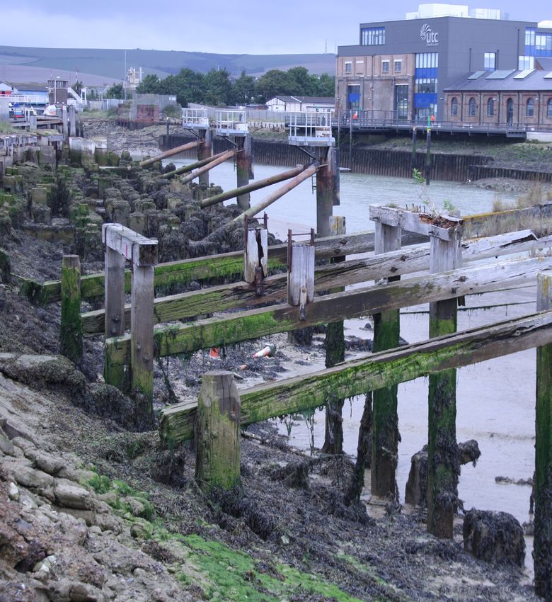
5.3.2 Coaling Wharf
The area that formed the Coaling Wharf in the First World War is today marked by large number of
piles some of which appear to have been have been cut off relatively close to the water line. There
are a mixture of wooden piles and concrete pile bases which once held wooden posts (Figure 24).
There appears to be two types of concrete piles, those with wooden posts set directly within them,
and others that used metal brackets to secure posts.
24Forgotten Wrecks of the First World War South Coast Ports in the First World War (2018)
Maritime Archaeology Trust
Figure 24: Piles at the former Coaling Wharf, Newhaven
5.3.3 Old Bridge
The remains of the supports for the old bridge over the River Ouse are visible on the eastern bank
(Figure 25), this is composed of red bricks.
Figure 25: Remains of old bridge over the River Ouse, eastern side
25Forgotten Wrecks of the First World War South Coast Ports in the First World War (2018)
Maritime Archaeology Trust
6. Folkestone
People have lived in and around what is now Folkestone since prehistoric times (A Brief History of
Folkestone). Since at least Roman times, trading ships had been landing on the shore at East Wear Bay
(Folkestone Harbour Arm). In 1843 a railway connected Folkestone to London and later the South
Eastern railway purchased the harbour which then became a successful cross-channel port,
stimulating a significant increase in the town’s population.
In 2010 a master planning exercise was carried out to redevelop the harbour and seafront. Clearance
of redundant and dilapidated buildings took place in 2014/15, other work included restoration of the
stonework and original steelwork on the harbour arm.
6.1 Folkestone during the First World War
Whereas Southampton and the LSWR were the focal point for the BEF embarkation and had a few
days’ notice to prepare, the South Eastern & Chatham Railway (SECR), which served south-east
England, was in the firing line from the very first day of the war with the arrival of thousands of
refugees caught between the rapid German advance and fleeing from the French and Belgian ports
across to the port of Folkestone. On one day 6,000 refugees were landed from Ostend alone, many of
them arriving with just the clothes they stood in. The SECR had to deal with the problem of feeding
them, finding temporary shelter and then getting them away from the coast to more permanent
accommodation.
SECR ferries used during the First World War between Dover / Folkestone and Calais / Boulogne
included:
• Canterbury (built 1901)
• The Queen (built 1903), the first SECR turbine, 1,676 gross tons. In 1916 it was captured and sunk
by a German destroyer.
• Invicta (built 1905), a development of The Queen and sister of Onward at 1,680 gross tons.
• Onward (built 1905), 1,671 gross tons. In 1918 Onward sank after catching fire at Folkestone.
• Victoria (built 1906), 1,689 gross tons.
• Empress (built 1907), 1914-1918 taken over by Royal Navy, 1923 transferred to France. 1,689
gross tons.
• Engadine (built 1911), 1914-1920 taken over by Royal Navy. Passed to Southern Railway in 1923.
1,676 gross tons.
• Riviera (built 1911), 1914-1920 taken over by Royal Navy. Passed to Southern Railway in 1923.
1,674 gross tons.
• Biarritz (built 1914), 2,495 gross tons.
• Maid of Orleans (built 1918). Passed to Southern Railway in 1923. In 1944 torpedoed and sunk in
English Channel. 2,384 gross tons.
1914 - 1918 saw the Folkestone Harbour Branch having to cope with an extraordinary amount of war-
time traffic. Shorncliffe Camp served as a training camp for thousands of recruits in training, and the
port was the main embarkation point for soldiers leaving to fight in the trenches
of France and Belgium. John Charles Carlile’s book Folkestone During The War 1914-1919 quotes
9,253,652 British officers and men as being processed together with 537,523 allied troops and 846,919
Red Cross and other workers. 102,641 tons of military and Red Cross freight was handled together
with 383,098 tons of mail and parcels and 63,985 tons of Expeditionary Force Canteens. Finally,
402,968 tons of coal was handled to power the vessels using the port.
Approximately 7,000 trains were handled for the military and 8,500 trains were operated by South
Eastern for its commercial service. Throughout the war the railway kept operating its regular services
as events in the Channel allowed.
26Forgotten Wrecks of the First World War South Coast Ports in the First World War (2018)
Maritime Archaeology Trust
6.2 Overview of Port Structures
A map of Folkestone dated 7 March 1919 was found within The National Archives, this has allowed a
comparison between the First World War structures (Figure 26) and the modern aerial photograph
images (Figure 27).
Figure 26: Folkestone Harbour, March 1919 (The National Archives)
Figure 27: Modern day Folkestone Harbour (CCO 2016)
27Forgotten Wrecks of the First World War South Coast Ports in the First World War (2018)
Maritime Archaeology Trust
6.3 Review of Surviving Remains from the First World War
6.3.1 Land to the south of the Inner and Outer Harbour
The Harbour arm remains, and there appears to be the railway/ trackway, shown on the 1919 map,
still in place. The railway terminal at the southern side of the Outer Harbour has been replaced by car
parking, and the Harbour Works yard site has been cleared, now hosting parking, and some light
industrial works (Figure 28).
Figure 28: Land to the south of the inner and outer Harbour (CCO 2016)
6.3.2 Centre and north of the Harbour
In the northern part of the Outer Harbour the jetties have been removed. At the Inner Harbour, the
slipway remains, as does the viaduct separating the two harbours (Figure 29).
Figure 29: The main harbour and area to the north (CCO 2016)
28Forgotten Wrecks of the First World War South Coast Ports in the First World War (2018)
Maritime Archaeology Trust
7. Dover
Dover’s history as a port town stretches back to the Roman period and as a valuable destination for
cross-channel ships, and further back for seafaring as witnessed by the discovery of the Dover Bronze
Age boat (Clark 2004). Richard the Lionheart set out on the Third Crusade from Dover as did Henry VIII
on his way to the Field of the Cloth of Gold (The History of the Port of Dover).
The front of the bay had always been affected by depositing of shingle in the lee of a pier created at
the behest of Henry VIII. This was solved in 1847 when the Admiralty Pier was built and the harbour
developed further in 1897 when construction began on the Eastern Arm, Southern Breakwater and
Admiralty Pier extension (ibid).
The total area of the harbour is around 1,050 acres, 700 of which are water. The Port of Dover is now
a major cross-channel ferry terminal and the Commercial Harbour is now used for leisure and light
industrial / commercial purposes.
7.1 Dover during the First World War
The port of Dover was exclusively taken over by the naval and military authorities and three SECR
steamers were also requisitioned for use by the Royal Navy (Empress, Engadine, Riviera operating
between Dover / Folkestone and Calais / Boulogne).
Between January 1915 and February 1919 an estimated 1,260,000 wounded and sick soldiers landed
at Dover and transited onwards through the station. From July 1917 men on leave and conscripts were
ferried out via Dover. 55,398 British prisoners of war came home through Dover after the Armistice.
720,664 soldiers were demobilised through Dover. In February 1919 all facilities were returned to
civilian control (Disused Stations 2018).
The Marine Station Building was constructed between 1912 and 1914 and opened for military use only
in early 1915 (The History of the Port of Dover 2018). It played a significant role in repatriating the sick
and wounded having been designated the principal ambulance railway station (Dover Marine Station
2018). Land was reclaimed from the harbour to make space for the terminal, and 1,200 ferro-concrete
piles were driven into the seabed. The building itself was 800ft by 170ft with a steel and glass concrete
roof in the train shed style (Disused Stations 2018).
7.2 Overview of Port Structures
The immediate post war docks are shown in Figure 30, Dover Harbour Plan (OCB 1698), Admiralty
Chart Branch, 23 October 1918, held at the United Kingdom Hydrographic Office.
29You can also read