Earthquake-induced debris flows at Popocatépetl Volcano, Mexico
←
→
Page content transcription
If your browser does not render page correctly, please read the page content below
Earth Surf. Dynam., 9, 393–412, 2021
https://doi.org/10.5194/esurf-9-393-2021
© Author(s) 2021. This work is distributed under
the Creative Commons Attribution 4.0 License.

                           Earthquake-induced debris flows at
                             Popocatépetl Volcano, Mexico
                   Velio Coviello1,a , Lucia Capra2 , Gianluca Norini3 , Norma Dávila4 , Dolors Ferrés5 ,
                                   Víctor Hugo Márquez-Ramírez2 , and Eduard Pico2
                       1 Facoltà di Scienze e Tecnologie, Free University of Bozen-Bolzano, Bolzano, Italy
        2 Centro  de Geociencias, Campus Juriquilla, Universidad Nacional Autónoma de México, Querétaro, México
             3 Istituto di Geologia Ambientale e Geoingegneria, Consiglio Nazionale delle Ricerche, Milan, Italy
                                   4 Escuela Nacional de Estudios Superiores, Campus Juriquilla,

                                  Universidad Nacional Autónoma de México, Querétaro, México
                    5 Escuela Nacional de Ciencias de la Tierra, Universidad Nacional Autónoma de México,

                                                    Ciudad de México, México
       a now at: Research Institute for Geo-Hydrological Protection, Consiglio Nazionale delle Ricerche, Padova, Italy

                                Correspondence: Velio Coviello (velio.coviello@unibz.it)

                                   Received: 27 April 2020 – Discussion started: 25 May 2020
                         Revised: 8 February 2021 – Accepted: 13 March 2021 – Published: 21 May 2021

      Abstract. The 2017 Mw 7.1 Puebla–Morelos intraslab earthquake (depth: 57 km) severely hit Popocatépetl
      Volcano, located ∼ 70 km north of the epicenter. The seismic shaking triggered shallow landslides on the volcanic
      edifice, mobilizing slope material saturated by the 3 d antecedent rainfall. We produced a landslide map based
      on a semi-automatic classification of a 50 cm resolution optical image acquired 2 months after the earthquake.
      We identified hundreds of soil slips and three large debris flows for a total affected area of 3.8 km2 . Landslide
      distribution appears controlled by the joint effect of slope material properties and topographic amplification.
      In most cases, the sliding surfaces correspond with discontinuities between pumice-fall and massive ash-fall
      deposits from late Holocene eruptions. The largest landslides occurred on the slopes of aligned ENE–WSW-
      trending ravines, on opposite sides of the volcano, roughly parallel to the regional maximum horizontal stress
      and to volcano-tectonic structural features. This suggests transient reactivation of local faults and extensional
      fractures as one of the mechanisms that weakened the volcanic edifice and promoted the largest slope failures.
      The material involved in the larger landslides transformed into three large debris flows due to liquefaction.
      These debris flows mobilized a total volume of about 106 m3 of material also including large wood, were highly
      viscous, and propagated up to 7.7 km from the initiation areas. We reconstructed this mass wasting cascade by
      means of field evidence, samples from both landslide scarps and deposits, and analysis of remotely sensed and
      rainfall data. Although subduction-related earthquakes are known to produce a smaller number of landslides than
      shallow crustal earthquakes, the processes described here show how an unusual intraslab earthquake can produce
      an exceptional impact on an active volcano. This scenario, not related to the magmatic activity of the volcano,
      should be considered in multi-hazard risk assessment at Popocatépetl and other active volcanoes located along
      volcanic arcs.

Published by Copernicus Publications on behalf of the European Geosciences Union.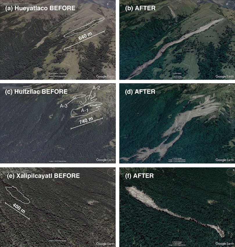
394                                     V. Coviello et al.: Earthquake-induced debris flows at Popocatépetl Volcano, Mexico

1   Introduction                                                   close to a critical state can be particularly susceptible to per-
                                                                   turbations produced by regional earthquakes. Volcanic land-
Earthquakes can induce large slope instabilities in tectoni-       slides include a wide spectrum of instability phenomena,
cally active regions, resulting in a relevant source of haz-       from small slope failures to large sector collapse evolving
ard and damage. Earthquake magnitude (M) and the result-           into catastrophic debris avalanches. Intermediate processes
ing intensity of ground vibration control the extent of the        such as shallow landslides and debris flows are common in
area where landslides may occur. One of the first compre-          the case of an earthquake, but they are relatively poorly doc-
hensive historical analyses of earthquake-induced landslides       umented for past events. Debris flows, often called lahar in
was done by Keefer (1984), who showed that the maximum             volcanic environments, are usually associated with eruptions
area likely to be affected by landslides during a seismic          that induce ice melt or snowmelt or with intense rainfalls oc-
event increases with M following a power law scaling re-           curring during intra-eruptive phases (e.g., Capra et al., 2018;
lationship. In the following years, a growing number of stud-      Major et al., 2016; Manville et al., 2009). Few examples of
ies started focusing on the impact of landsliding caused by        long-runout debris flows triggered by earthquakes have been
large-magnitude earthquakes along relatively shallow crustal       described on active volcanoes (Schuster et al., 1996; Scott
faults. In particular, it was observed that the fault rupture      et al., 2001). In Mexico, a Mw 6.5 earthquake that occurred
mechanism strongly influences the distribution of landslides,      in 1920 induced several landslides in the Pico de Orizaba–
which are usually more abundant on the hanging wall in the         Cofre de Perote volcanic chain that transformed into debris
case of reverse or normal faults (Sato et al., 2007) and present   flows with catastrophic effects for villages along the Huizila-
a symmetric distribution in the case of strike-slip faulting (Xu   pan ravine (Camacho, 1920; Flores, 1922). More recently,
and Xu, 2014). In the case of co-seismic landslides related to     several thousands of shallow landslides were triggered by the
earthquakes in subduction zones, very few data and invento-        Tecomán earthquake of 21 January 2003 (Mw 7.6) in the vol-
ries are available (LaHusen et al., 2020; Schulz et al., 2012;     canic highlands north and northwest of Colima City (Keefer
Serey et al., 2019; Wartman et al., 2013). Best examples are       et al., 2006).
the landslides induced by the 2010 Chile megathrust earth-            In this paper, we investigate the exceptional mass wast-
quake (Serey et al., 2019) and by the 2011 Tohoku earth-           ing episode triggered by the 19 September 2017 Mw 7.1
quake in Japan (Wartman et al., 2013). In both cases, thou-        Puebla–Morelos intraslab earthquake along the eastern and
sands of shallow landslides were identified, but the main con-     western sides of Popocatépetl Volcano. The seismic shaking
clusion of these works is that the number of landslides gen-       mobilized pre-existing ash and pumice-fall deposits, produc-
erated by megathrust earthquakes is smaller than the num-          ing hundreds of co-seismic soil slips. The largest ones had
ber of events triggered by shallow crustal earthquakes by at       a total volume of about 106 m3 and transformed into debris
least 1 or 2 orders of magnitude. Today, we know that the          flows that traveled up to 7.7 km on the western side of the
spatial distribution of earthquake-induced landslide is also a     volcanic edifice. This phenomenon, never studied before at
function of geological parameters (e.g., contrast in rock co-      Popocatépetl Volcano and probably unique on an active stra-
herence, permeability), topography (slope and shape), land         tovolcano along a continental volcanic arc, has important im-
cover and land use, and ground-motion characteristics such         plications for hazard assessment, as the actual hazard map
as amplification and shaking frequency (Fan et al., 2019; Von      only includes the impact of lahars related to volcanic activity
Specht et al., 2019). Concerning the impact of earthquake          (Martin Del Pozzo et al., 2017). In the following, we provide
on sediment-related hazards, a dramatic increase in sediment       a general introduction to the geomorphology of Popocatépetl
yield has been documented after large earthquake-induced           Volcano and to its recent volcanic activity. Then, we describe
landslides (Pearce and Watson, 1986; Dadson et al., 2004;          the impact of the Mw 7.1 Puebla–Morelos earthquake on the
Marc et al., 2019). Progressively, source areas on highlands       volcano slopes in terms of ground vibrations and landslide
can become quickly stable as fine material is removed and          activity. Finally, we reconstruct the transformation of the ma-
new vegetation grows and stabilizes the slope (Domènech et         jor landslides into long-runout debris flows, and we discuss
al., 2019), but debris flows can still occur due to the remobi-    the hazard implication for an active volcano.
lization of deposited material along the channel (Fan et al.,
2021).
                                                                   2     Background
   On active volcanoes, a large variety of factors can promote
slope instability and failure; these are magma intrusions,         2.1    Popocatépetl Volcano
hydrothermal activity, gravitational spreading of the base-
ments, climate fluctuations, and regional tectonics (Capra         Popocatépetl Volcano (19◦ 030 N, 98◦ 350 W; elevation
et al., 2013; Mcguire, 1996; Norini et al., 2008; Roberti et       5450 m a.s.l.) is located in the central sector of the Trans-
al., 2017; Roverato et al., 2015). In particular, earthquakes      Mexican Volcanic Belt (TMVB) and represents the active
are recognized to play one of the most important roles in          and southernmost stratovolcano belonging to the Sierra
the initiation of slope failures on volcanoes (Kameda et al.,      Nevada volcanic chain (Pasquaré et al., 1987) (Fig. 1a, b).
2019; Sassa, 2005; Siebert, 2002). Volcanic slopes that are        The Popocatépetl is a composite volcano, and its present

Earth Surf. Dynam., 9, 393–412, 2021                                                  https://doi.org/10.5194/esurf-9-393-2021
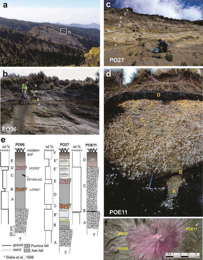
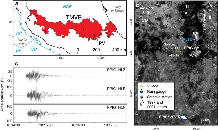
V. Coviello et al.: Earthquake-induced debris flows at Popocatépetl Volcano, Mexico                                         395

shape is the result of eruptive activity that rebuilt the         ditions suddenly changed during the Mw 7.1 Puebla–Morelos
modern cone after the 23.5 ka flank collapse (Siebe et            earthquake.
al., 2017). During the Last Glacial Maximum (20–14 ka)
glacier activity resulted in extensive moraines and glacial       2.2    The Mw 7.1 intraslab Puebla–Morelos earthquake
cirques (Vázquez-Selem and Heine, 2011). The lower part
of the cone features a gentle slope (10–15◦ ) and a dense         On 19 September 2017, central Mexico was hit by a Mw 7.1
vegetation cover up to approximately 3800 m a.s.l. (Fig. 2a),     intraslab seismic event (depth: 57 km) named the Puebla–
where pine trees became scattered and surrounded by dense         Morelos earthquake (Melgar et al., 2018; Singh et al., 2018).
tropical alpine grasslands (zacatonal alpino, Almeida et al.,     The epicenter of the earthquake was located ∼ 70 km south
1994) that can measure up to 1 m in height. Then, the cone        of the summit of Popocatépetl Volcano and ∼ 100 km south
becomes progressively steeper (20–30◦ ) and unvegetated up        of Mexico City (Fig. 1b). The focal mechanism corresponds
to the summit. In the upper portion of the cone, the slopes       to a normal fault with a dip angle of 44–47◦ (Melgar et al.,
are covered by abundant unconsolidated ash named “Los             2018). The 2017 Mw 7.1 Puebla–Morelos earthquake pro-
Arenales” from the recent vulcanian eruptions (Fig. 2a).          duced the most intense ground shaking ever recorded in Mex-
   Quaternary volcanic activity of Popocatépetl Volcano has       ico City during a subduction-related earthquake and was the
been characterized by catastrophic episodes including sec-        most damaging event for this densely urbanized part of the
tor collapses and Plinian eruptions that emplaced pyroclas-       country since the 1985 Mw 8.1 Michoacán interplate earth-
tic density currents and thick pumice-fall deposits, pre-         quake, which occurred exactly 32 years before (Singh et al.,
dominantly toward the east and northeast (Fig. 1b) (Siebe         2018). The damage was surprisingly large in the critical fre-
and Macías, 2006). Based on its Holocene eruptive record,         quency range for Mexico City (0.4–1 Hz), where the earth-
Plinian eruptions at Popocatépetl have occurred with a vari-      quake severely damaged hundreds of buildings and killed
able recurrence time of about 1–3 kyr (Siebe et al., 1996).       369 people (Singh et al., 2018). The 2017 intraslab earth-
Since 1994, the volcano entered a new eruptive phase, which       quake occurred closer to Mexico City, at greater depth, and
includes dome growths that are subsequently destroyed dur-        involved a higher stress drop than its interplate counterparts,
ing strong vulcanian eruptions with columns up to 8 km in         such as the 1985 Michoacán event. The stress drops of in-
height, accompanied with ash fall that has been affecting         traslab events have been estimated as being ∼ 4 times greater
populations in a radius of approximately 100 km. Eruptive         than that of the interplate earthquakes (García et al., 2005)
activity played the primary role in accelerating the glacier      and the ground acceleration of the intraslab earthquakes are
retreat on the northern slope of the volcano (Julio-Miranda et    expected to be more enriched at higher frequencies than
al., 2008).                                                       those of the interplate events (Furumura and Singh, 2002;
   In recent time, only two large lahar events were observed      Singh et al., 2018). During the 2017 Mw 7.1 Puebla–Morelos
along the Huiloac Gorge (Hg, Fig. 1b), i.e., in 1997 and 2001,    earthquake, the peak ground acceleration (PGA) recorded at
associated with eruptive phases (Capra et al., 2004). At those    station Ciudad Universitaria (CU) was the highest recorded
times, the Ventorillo glacier was still present on the northern   in the last 54 years of observations (57.1 cm s−2 ) (Singh
face of the volcano. Both lahars propagated to the town of        et al., 2018). Station CU is located on the external bound-
Santiago Xalitzintla (SX, Fig. 1b), located ∼ 15 km E of the      ary of the sedimentary basin responsible for the well-known
volcano summit. The 1997 lahar originated after a prolonged       seismic amplification at Mexico City (Fig. 1b). The strong
explosive activity with emission of ash, which caused the         ground motion recorded at PPIG station (Fig. 1c), located
partial melt of the glacier. The rapid release of water gradu-    at 3980 m a.s.l. on Popocatépetl Volcano’s slopes, featured a
ally eroded the riverbed and triggered a debris flow. The 2001    much higher value of PGA (106.83 cm s−2 , 0.1 g) than the
lahar originated from the remobilization of a pumice flow         one observed at station CU.
deposit emplaced over the Ventorillo glacier on the north-
ern side of the volcano. The event occurred ∼ 5 h after the       3     Data and methods
pyroclastic flow emplacement, and the debris flow was char-
acterized by a stable sediment concentration of 0.75 (Capra       We adopted a combined field- and remote-based approach
et al., 2004). In the distal part, the 1997 lahar transformed     to retrieve information about the earthquake impact on such
into a hyperconcentrated flow, while the 2001 one maintained      a difficult to access environment. Semi-automated satellite-
the characteristics of a debris flow due to its apparent co-      image classification is a rapidly developing tool producing
hesion conferred by a silty-rich matrix inherited from the        reliable landslide maps (e.g., Fan et al., 2019, and refer-
pumice flow deposit. Apart from the Huiloac Gorge, which          ences therein). We used optical satellite data to identify the
was characterized by significant geomorphic transformations       main areas affected by landslides and to constrain the tim-
due to these latter processes (Tanarro et al., 2010), most of     ing of the landslide occurrences with respect to the earth-
the drainage network of Popocatépetl Volcano has a dense          quake event (Fig. 2a, b). We constructed a preliminary land-
vegetation cover and presents stable, low-energy sediment         slide map (Fig. 2c) based on the interpretation of an archive
transport conditions (Castillo et al., 2015). These stable con-   Pléiades 1A image (incidence angle of 14.63◦ , resolution of

https://doi.org/10.5194/esurf-9-393-2021                                               Earth Surf. Dynam., 9, 393–412, 2021
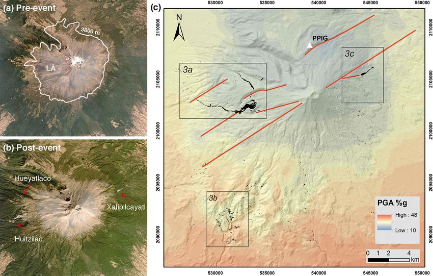
396                                        V. Coviello et al.: Earthquake-induced debris flows at Popocatépetl Volcano, Mexico

Figure 1. (a) Plate tectonic settings of Central Mexico (CP – Cocos Plate; NAP – North America Plate; RP – Rivera Plate; PP – Pacific Plate;
MAT – Middle American Trench) and location of Popocatépetl Volcano (PV) in the Trans-Mexican Volcanic Belt (TMVB). (b) Details of
the area affected by the Mw 7.1 Puebla–Morelos earthquake and location of the seismic stations CU and PPIG and of the rain gauge ALTZ.
Popocatépetl Volcano (PV) is the southernmost edifice of the Sierra Nevada volcanic chain along with the Iztaccihuatl (IzV), Telapón (Te),
and Tláloc (Tl) volcanoes. The main distribution areas of the pumice-fall deposits from the last two Plinian eruptions of the PV are indicated
with white dashed lines (background image Landsat/Copernicus from Google Earth: © Google 2020, © INEGI 2020). (c) Strong motion
recorded at station PPIG during the Puebla–Morelos earthquake on 19 September 2017 (channel HLZ refers to the vertical component,
channels HLE and HLN to horizontal components).

0.5 m) acquired 2 months after the earthquake. A normalized              oratory) and calibrated with the IntCal20 calibration curve
difference vegetation index (NDVI) was calculated using                  (Reimer et al., 2020). We mapped and sampled main debris-
band 1 (red) and band 4 (infrared). The resulting raster was             flow deposits, and grain size analyses was performed by dry-
classified for excluding vegetation cover, roads, and build-             sieving for the sand fraction and by means of a laser particle
ings from the analysis and selecting only landslide scars or             sizer (Analysette 22) for silt and clay fractions.
depositional areas. The final map (Fig. 2c) was validated and               We analyzed two Sentinel-1 SAR images (synthetic aper-
refined based on data that we collected in the field. Most               ture radar, Copernicus program) to define the timing be-
landslides are located on the W side, on the E side, and on              tween the earthquake and the observed mass wasting pro-
the SE side of the volcanic edifice (Fig. 3).                            cesses (Fig. 9). The analyzed images were acquired before
   We conducted four field campaigns from October 2017 to                and after the earthquake (17 and 23 September 2017) in
November 2019 to investigate the morphology and stratigra-               1A level ground-range-detected, ascending-orbit, interfero-
phy of the source area of main landslides, to map and mea-               metric wide-sensor mode and dual polarization. A radiomet-
sure faults and fractures caused by the earthquake, and to de-           ric calibration was applied to extract the most significant
fine the extension, thickness, and textural characteristics of           amount of backscattering information from the ground linked
the larger debris flows (Fig. 4). The stratigraphy on the main           to the surficial roughness. As a second step, a change detec-
landslide scars was reconstructed to determine texture and               tion technique named log ratio was applied to detect pixel
physical properties of the tephra layers involved in the mass            values directly related to radar backscattered and correlated
wasting process. We selected a soil sample for radiocarbon               to superficial processes; this is an algorithm used to detect
analysis to identify the age of the stratigraphic sequence and           changes using a mean ratio operator between two images of
to define its distribution. The 14 C age was obtained through            the same area but taken at different times (Mondini, 2017;
accelerator mass spectrometry dating (BETA Analytic Lab-                 Singh, 1989). Finally, we analyzed rainfall data gathered at

Earth Surf. Dynam., 9, 393–412, 2021                                                          https://doi.org/10.5194/esurf-9-393-2021
V. Coviello et al.: Earthquake-induced debris flows at Popocatépetl Volcano, Mexico                                                 397

Figure 2. Optical images of Popocatépetl Volcano acquired before and after the Mw 7.1 Puebla–Morelos earthquake (images © DigitalGlobe)
and landslide map. In the pre-event image (a) acquired on 23 March 2017, the 3800 m line and Los Arenales (LA) deposits are indicated in
white. In the post-event image (b) acquired on 11 December 2017, the red arrows indicate the debris flows that occurred in the Huitzilac,
Hueyatlaco, and Xalipilcayatl ravines. In the landslide map (c), the black polygons corresponding to landslide scars and deposits were
extracted from a Pléiades 1A image acquired on 13 November 2017. Main volcano-tectonic lineaments are reported in the map (red lines).
The white triangle indicates the PPIG seismic station where a PGA of 106.83 cm s−2 was measured (Fig. 1c). The black squares indicate the
areas zoomed in Fig. 3. Background: map of the PGA distribution (data source: USGS National Earthquake Information Center, Worden et
al., 2010) and 12.5 m DEM © JAXA/METI ALOS PALSAR 2008 (coordinate system WGS84 UTM Zone 14Q).

the Altzomoni rain gauge station (ALTZ, Fig. 1b), located              on the valley flanks (Fig. 5b), suggesting a correlation with
approximately 10 km north of the volcano summit.                       local gravitational instability triggered by seismicity. A clus-
                                                                       ter of smaller shallow landslides is visible on the southwest-
                                                                       ern side of the volcanic cone (Fig. 2c). These landslides were
4     Results                                                          produced by the collapse of the steep slopes of hummocky
                                                                       hills (Figs. 2, 3b) corresponding to the debris avalanche de-
4.1    Landslide mapping                                               posit of the last major flank failure that occurred at 23.5 ka
The earthquake triggered hundreds of shallow landslides on             (Espinasa-Perena and Martín-Del Pozzo, 2006; Siebe et al.,
the volcano slopes covering a total area of 3.8 km2 (Fig. 2).          2017).
Soil slips affected the modern soil and part of the uncon-                The scarps or the larger landslides located on the west-
solidated volcaniclastic cover. The five largest slope failures        ern slope of the volcano show a similar stratigraphy, with
occurred in the basins of Hueyatlaco and Huitzilac on the              the intercalation of pumice- and ash-fall deposits (Fig. 6a–
west side of the volcanic edifice and in the basin of Xalip-           c). Pumice-fall deposits consist of open-framework, clast-
ilcayatl on the east (Fig. 4). The scarps of these landslides          supported units composed of gravel–sand-sized fragments of
were generated at elevations of about 3400–3800 m a.s.l. on            pumice embedded in a matrix of fine material (from silt to
the internal faces of ravines or glacial cirques, where slopes         clay). Two main layers of pumice-fall deposit were observed
are > 20◦ (Fig. 4c). Sharp rectilinear extensional fractures           at the Hueyatlaco and Huitzilac landslide scars (layers B and
and small normal faults parallel to the valley slopes were ob-         D, section PO1906; layers C and E, section PO1927; Fig. 6e).
served in the Hueyatlaco basin after the earthquake (Fig. 5a).         Another pumice-fall deposit crops out at the base of the pyro-
These faults and fractures have a maximum length of about              clastic succession. The fallout deposits are intercalated with
1 km, show displacements of up to 40–50 cm, and are located            massive or stratified ash layers, with variable thicknesses up

https://doi.org/10.5194/esurf-9-393-2021                                                     Earth Surf. Dynam., 9, 393–412, 2021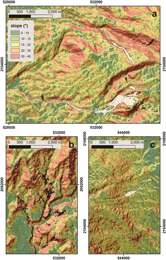
398 V. Coviello et al.: Earthquake-induced debris flows at Popocatépetl Volcano, Mexico
of any silt and clay fractions. This latter unit lies on a 10 cm
thick sandy layer (B in Fig. 6d). In all the studied sections,
the upper ash unit corresponds to the products accumulated
from the frequent vulcanian explosions that characterize the
modern eruptive activity of the volcano.
4.2 Characterization of debris flows and associated
deposits
The five largest landslides described in Sect. 4.1 (one each
at Hueyatlaco and Xalipilcayatl and three at Huitzilac) mo-
bilized a total volume of about 1.35 × 10⁶ m3 of ash- and
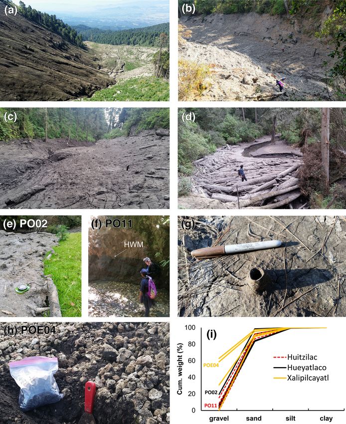
pumice-fall deposits (Table 1). Landslide scarps measured
640 m in length and 4 m in depth at Hueyatlaco, 740 m in
length and 3 m in depth at Huitzilac, and 400 m in length and
3 m in depth at Xalipilcayatl (Fig. 7). We calculated the vol-
ume of the landslides by assuming a constant depth (with an
uncertainty of ±0.5 m) over the area of detachment. We mea-
sured the depth of the main scars in the field while the area
of the main scars was inferred from field surveys and from
the inspection of post-event optical images (Fig. 7).
The landslides transformed into three long-runout debris
flows (Fig. 8). At the Huitzilac ravine, the main landslide
body (landslide A-1, Fig. 7c) impacted the opposite side of
the valley, partly overtopping it (Figs. 4c and 8a). Two other
soil slips (landslide A-2 and A-3, Fig. 7c) contributed to
forming the subsequent debris flow, which extended up to
7.7 km from the source before diluting into a streamflow. The
total observed thickness of the deposit measures up to 3 m,
but mud traces on standing trees and on lateral terraces mea-
sure up to 10 m on proximal reaches (PO17, Fig. 8b) and up
to 1.5 m in distal reaches with horizontal surfaces at benches
Figure 3. Details of the most affected areas of Popocatépetl
Volcano by co-seismic landslides. Black polygons correspond to (PO11, Fig. 8f). In distal reaches, where the channel was
shallow-landslide scars and deposits, and whitish areas indicate de- shallow, the flow inundated large plains (PO15 and PO19).
bris flows. Location of panels (a), (b), and (c) is reported in Fig. 2. The deposit is massive and dark-gray in color and mainly
Background: 12.5 m DEM © JAXA/METI ALOS PALSAR 2008 consists of sand (77 %–86 %) with a relevant gravel propor-
(coordinate system WGS84 UTM Zone 14Q). tion (15 %) due to pumice fragment enrichment in proximal
reaches (Fig. 8i). Clay content is less than 1 %. The lower
unit consists of coarse-to-medium ash with evidence of de-
to 4 m. They mainly consist of sand (71 %–93 %), silt (16 %– watering (Fig. 8g). At Hueyatlaco, the debris-flow runout ex-
1 %), and less than 1 % of clay (see Appendix A). A sample tended up to 6.4 km (Fig. 4). The deposit appears as a main
from layer C (section PO06) was dated by using 14 C, giv- unit, dark-gray in color, massive, and homogeneous, with a
ing a calibrated age of 537–643 CE (1500 ± 30 BP conven- sand fraction consisting of 70 % in proximal reaches (PO01)
tional radiocarbon age) (Fig. 6e). Based on this age, the two to 87 % in distal reaches (PO05), with up to 15 % of silt and
younger pumice-fall deposits are here correlated with the up- less than 1 % of clay (Fig. 8i; see also Appendix A). Over-
per and lower classic Plinian eruptions (UCPES and LCPES) bank deposits show sharp edges up to 10 cm thick (PO02,
of the late Holocene, which had a main dispersal axis to- Fig. 8e). The total observed thickness is up to 50 cm (Fig. 8d;
wards the east and northeast (Fig. 1b) (Siebe et al., 1996). erosion was only incipient at the time of the observation) but
The thicker deposits of these eruptions crop out on the east- watermarks of up to 5 m were observed in proximal reaches
ern flank of the volcano, as observed at section PO11, and (PO1701, Fig. 8c). Finally, the deposit in the Xalipilcayatl
correspond to the scar of the Xalipilcayatl landslide (Fig. 6d). ravine extended up to 1.5 km (Fig. 7f) and is clearly com-
Here, a main unit of pumice-fall deposit (C in Fig. 6d) fea- posed of two main units. The lower unit is massive and dark-
tures a total thickness of 3.5 m and consists of a massive, gray in color and mostly consists of sand fraction (88 %,
clast-supported unit dominated by coarse fragments barren POE03-lower; Fig. 8i), up to 1.2 m in thickness, while the
Earth Surf. Dynam., 9, 393–412, 2021 https://doi.org/10.5194/esurf-9-393-2021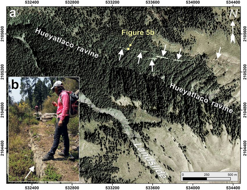
V. Coviello et al.: Earthquake-induced debris flows at Popocatépetl Volcano, Mexico                                                  399

Figure 4. (a) Map of three ravines of Popocatépetl Volcano affected by the debris flows; black dots indicate locations of field surveys
(background: 12.5 m DEM © JAXA/METI ALOS PALSAR 2008; coordinate system WGS84 UTM Zone 14Q). (b) View in the downstream
direction from the top of the sampling point PO06, located on the scarp of the Huitzilac landslide. (c) Topographic profiles of the larger
landslides (1 and 2) that occurred at Huitzilac, which are also reported on the Pléiades 1A image acquired on 13 November 2017; the black
arrow indicates the topographic barrier overtopped by the debris flow.

upper one is massive and pumice-enriched and represents up             (Table 2). Large wood (LW) elements entrained by the initial
to 40 % of the total unit (POE04, Fig. 8h and i).                      landslides and the subsequent debris flows contributed to the
   We estimate a total entrainment of about 205 000 m3 along           final bulk deposits of about 1.632 × 10⁶ m3 . The volume of
both hillslopes and a channel network assuming 0.5 m of ero-           LW was calculated considering a mean tree height of 25 m
sion over the area located downstream from the main scars              (measured in the field, with an uncertainty of ±5 m), a mean

https://doi.org/10.5194/esurf-9-393-2021                                                      Earth Surf. Dynam., 9, 393–412, 2021

400                                        V. Coviello et al.: Earthquake-induced debris flows at Popocatépetl Volcano, Mexico

Figure 5. (a) Rectilinear extensional fractures and small normal faults opened parallel to the Hueyatlaco ravine (white arrows); background
image: Pléiades 1A image acquired on 13 November 2017. (b) Detail of the normal displacement of about 50 cm (white arrow). Coordinate
system WGS84 UTM Zone 14Q.

Table 1. Main morphometric data of the landslides that occurred in the headwaters of the Hueyatlaco, Huitzilac, and Xalipilcayatl ravines.
The area of the main scars was inferred from the inspection of post-event optical images (see Fig. 8). The depth of the scars was measured in
the field. The volume of the landslides was calculated assuming a constant depth (with an uncertainty of ±0.5 m) over the area of detachment.

                                               Max elevation        Area       Depth    Slope      Volume ×103
                                                        (m)         (m2 )        (m)       (◦ )           (m3 )
                               Hueyatlaco               3860      60 000           4       29           240 ± 30
                               Huitzilac                3700     310 000           3    31–32          930 ± 155
                               Xalipilcayatl            3500      60 000           3       25           180 ± 30

trunk diameter of 0.4 m (observed in the field, with an uncer-              low the collapses (62 %), while in the Hueyatlaco basin most
tainty of ±0.1 m), and a mean distance of two trees of 10 m                 came from the channel banks (75 %). Most of the transported
(estimated by using the post-event optical images; see Fig. 7).             LWs remained trapped by natural obstacles in the main chan-
The amount of LW recruited in the Huitzilac basin results                   nel (i.e., standing vegetation) and clogged in the flat reaches
was 60 000 m3 (±3000 m3 ), far more than the sum of wood                    of the channel (Fig. 8d). In the Xalipilcayatl ravine, most of
recruitment estimated for the Hueyatlaco (10 000 ± 500 m3 )                 LW was transported for the whole runout distance into the
and Xalipilcayatl (7000 ± 350 m3 ) basins. The recruited LW                 main landslide deposit.
stemmed from the combination of hillslope and channel pro-
cesses originating from the earthquake-induced landslides.                  4.3   Timing of the events
In general, these landslides were the dominant recruitment
processes in headwaters. In contrast, LW recruitment from                   Results of Sentinel-1 SAR image processing clearly indicate
lateral bank erosion became significant in the intermediate                 that both landslides and debris flows occurred between 17
reaches of the channels. The slope area that collapsed into the             and 23 September 2017. A binary image was produced where
Xalipilcayatl basin contained most of the LWs that was later                pixels values are linked to spatial change that occurred in this
transported by the flow (86 %). In the Huitzilac basin, the LW              time span (Fig. 9a). Their distribution corresponds with the
recruitment mainly occurred on the slopes located right be-                 deposits of the larger debris flows that occurred in the Huitzi-
                                                                            lac and Hueyatlaco basins, as is easily observable in a later

Earth Surf. Dynam., 9, 393–412, 2021                                                              https://doi.org/10.5194/esurf-9-393-2021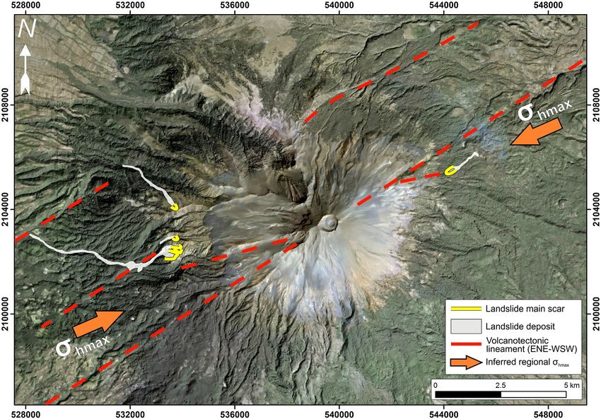
V. Coviello et al.: Earthquake-induced debris flows at Popocatépetl Volcano, Mexico                                                        401

Figure 6. View of the three main landslides scarps: (a, b) Huitzilac, (c) Hueyatlaco, (d) Xalipilcayatl. In panel (e) the stratigraphic sections
of the scarps and the grain size distributions of their strata (data in Appendix A) are reported; upper classic Plinian eruptions (UCPES, pink),
lower classic Plinian eruptions (LCPES, orange), and the dated layer are indicated; see text for more details. (f) Geographic location of
sampling points; background image: Pléiades 1A image acquired on 13 November 2017.

optical Sentinel-2 image (Copernicus program) acquired on                 that between 19 and 23 September only a few millimeters of
18 October 2017 (Fig. 9b).                                                rainfall accumulated (Fig. 10), it is thus highly probable that
   A total of 200 mm of accumulated rainfall were recorded                both slope failures and debris-flow emplacement were co-
during the 30 d preceding the earthquake, with the accumula-              seismic. Witnesses from the town of Atlautla, which is lo-
tion of 19.7 mm 2 d before the earthquake (Fig. 10). Thus, we             cated at the outlet of the Huitzilac ravine (Fig. 1b), also con-
expect that the slope material was wet at the time of the earth-          firmed this information. During the following weeks, rainfall
quake. Based on the remote-sensing analysis and considering               remobilized fine material from the landslide deposits reach-

https://doi.org/10.5194/esurf-9-393-2021                                                          Earth Surf. Dynam., 9, 393–412, 2021
402                                        V. Coviello et al.: Earthquake-induced debris flows at Popocatépetl Volcano, Mexico

Figure 7. Comparison of 3D views on the detachment areas in the headwaters of the Hueyatlaco (a, b), Huitzilac (c, d), and Xalipilcayatl (e, f)
ravines before and after the larger landslides. Images from Google Earth (© Google 2018, © INEGI 2018, and © DigitalGlobe 2019).

                                                                          ing the town of San Juan Tehuixtitlán (Fig. 4a). On 4 Oc-
Table 2. Main morphometric data of the debris flows that were ob-         tober 2017, the population of San Juan Tehuixtitlán noticed
served in the Hueyatlaco, Huitzilac, and Xalipilcayatl basins. The        the transformation of the shallow water flow of the Huey-
entrained volume was calculated assuming 0.5 m of erosion over            atlaco ravine into a hyperconcentrated flow. It was the first
the area located downstream from the main scars where the vege-           time that this local community located on the western vol-
tation was destroyed. The volume of large wood (LW) recruitment           cano slope observed such a phenomenon. Rainfall measure-
was calculated considering a mean tree height of 25 m (with an un-        ment at Altzomoni rain gauge station (ALTZ, Fig. 1b) shows
certainty of ±5 m), a mean trunk diameter of 0.4 m (with an uncer-
                                                                          an accumulation of 35.7 mm of rainfall over 12 h beginning
tainty of ±0.1 m), and a mean distance of two trees of 10 m based
on field observations and inspection of post-event optical images.
                                                                          at 10:00 UTC on 4 October, with a peak between 20:00 and
                                                                          21:00 UTC (Fig. 10). The rainfall event of 4 October only re-
                  Runout     Drop     Entrainment     LW volume
                                                                          mobilized fine material from the landslide deposits reaching
                    (km)    height          ×103          ×103            the town of San Juan Tehuixtitlán; the debris flows along the
                              (m)            (m3 )         (m3 )          Huitzilac and Xalipilcayatl were never reported since they
                                                                          never extended out to any populated area in 2017. During
 Hueyatlaco           6.4     1160              50       10 ± 0.5         the 2018 and 2019 rainy seasons, the fine sediment remo-
 Huitzilac            7.7     1200             120         60 ± 3
                                                                          bilized from the debris-flow deposit in the Huitzilac ravine
 Xalipilcayatl        1.5      350              35       7 ± 0.35
                                                                          reached the road connecting San Juan Tehuixtitlán to Atlautla
                                                                          (Fig. 1b).

Earth Surf. Dynam., 9, 393–412, 2021                                                          https://doi.org/10.5194/esurf-9-393-2021
V. Coviello et al.: Earthquake-induced debris flows at Popocatépetl Volcano, Mexico 403
Figure 8. Debris-flow deposits in the upper (a–c), intermediate (d–f), and lower reaches (g–h) of the Huitzilac, Hueyatlaco, and Xalipilcayatl
basins: (a) scarp of landslide A-1 at Huitzilac (view from point PO06), (b) main channel of the Huitzilac ravine (PO17), (c) main channel of
the Hueyatlaco ravine (PO1701), (d) large wood deposits at Hueyatlaco (PO03), (e) overbank deposits at Hueyatlaco (PO02), (f) mud trace
on lateral terraces at Huitzilac (HWM: height of watermark) (PO11), (g) evidence of dewatering at Huitzilac (PO19), (h) detail of the lower
deposit at Xalipilcayatl (POE04), and (i) grain size distribution of the samples of the deposits.
5 Discussion dikes within the volcanic cone and recent eruptive fissures on
its flanks (Arámbula-Mendoza et al., 2010; De Cserna et al.,
5.1 Predisposing factors to slope instabilities 1988).
The size of the slope failures triggered by the 2017
The Popocatépetl area is tectonically characterized by a Mw 7.1 Puebla–Morelos earthquake is highly variable al-
Quaternary, roughly NE–SW- or ENE–WSW-trending max- though (i) the epicenter of the earthquake is far from the vol-
imum horizontal stress regime, responsible for arc-parallel cano, with seismic shaking expected to be of similar inten-
E–W-striking transtensive faults and NE–SW or ENE–WSW sity all over the symmetric volcanic cone, and (ii) soil and
arc-oblique normal faults (Arámbula-Mendoza et al., 2010; recent pyroclastic cover is quite homogeneous on the edifice
García-Palomo et al., 2018; Norini et al., 2006, 2019). This flanks. Small shallow landslides occurred all over the vol-
stress regime generated ENE–WSW extensional fracturing cano flanks, while the few larger landslides described in our
and faulting of the volcanic edifice (Fig. 11), controlling work are limited to the eastern and western sides of the vol-
the orientation and propagation by magmatic overpressure of
https://doi.org/10.5194/esurf-9-393-2021 Earth Surf. Dynam., 9, 393–412, 2021404 V. Coviello et al.: Earthquake-induced debris flows at Popocatépetl Volcano, Mexico
deformation by the opening of fractures that promoted the
largest slope failures triggered by the earthquake.
5.2 Initiation of co-seismic landslides
Slopes collapse when the shear stress across a potential fail-
ure plane exceeds the substrate strength. Earthquakes reduce
the slope stability and can cause landslides through the per-
turbation of the normal and shear stresses in the slope. In the
case of soft, saturated soils, the coalescence of cracks during
earthquakes may results in liquefaction due to the increase
in substrate permeability. At Popocatépetl Volcano, a combi-
nation of these two mechanisms produced the soil slips ob-
served in the headwaters of the Hueyatlaco, Huitzilac, and
Xalipilcayatl basins. Shapiro et al. (2000) already noticed
that a large earthquake occurring in the vicinity of the vol-
cano may result in flank instability because of the seismic
waves traversing the poorly consolidated material compos-
ing the volcanic edifice. The ground motion during the 2017
earthquake was anomalously large in the frequency range
0.4–1 Hz, as intraslab earthquakes involve a higher stress
drop than their interplate counterparts (Singh et al., 2018).
Consequently, the ground motion is relatively enriched at
high frequencies as compared with that during interplate
earthquakes, which is dominated by lower-frequency waves
(f < 0:5 Hz), and this effect can contribute to explaining the
Figure 9. (a) RGB (R, post-earthquake; G, pre-earthquake; B, high value of PGA measured on the volcano slope.
ratio between post- and pre-event) representation of the 17 and Unexpectedly large peak accelerations have been recorded
23 September Sentinel-1 (© Copernicus data) change in amplitude along crests of mountain ridges during several earthquakes
analysis. (b) RGB composition of post-event Sentinel-2 image (©
(Davis and West, 1973; Meunier et al., 2008). Topographic
Copernicus data). Coordinate system WGS84 UTM Zone 14Q.
amplification of ground vibrations is primarily due to the
reflection or diffraction of seismic waves, which are pro-
gressively focused upwards (Bouchon et al., 1996; Davis
canic cone (Fig. 2). Thus, seismic shaking originating from and West, 1973). The constructive interference of reflections
the earthquake triggered large (volume > 105 m3 ) landslides and the associated diffractions of seismic waves increase to-
only in specific sectors of the volcano flanks. wards the ridge crest also due to local geologic factors, giving
The location of the larger slope failures defines a sharp rise to enhanced ground accelerations on topographic highs
ENE–WSW unstable sector, crossing the volcano summit (Del Gaudio and Wasowski, 2007; Meunier et al., 2008; Von
and parallel to many deep rectilinear valleys carved in the Specht et al., 2019). Geli et al. (1988) show that topographic
volcanic cone (Fig. 11). In this ENE–WSW elongated sector complexity (presence of neighboring ridges) may be respon-
of the volcano, some faults and extensional fractures were sible for large crest or base amplifications resulting in com-
generated by the 2017 earthquake in the same basins where plex amplification–deamplification patterns and significant
the larger landslides occurred (Fig. 5). This configuration differential motions along the slopes. The amplification at the
suggests strongly localized site effects and/or a structural crest of a mountain can be as large as or larger than the am-
control on the location of the slope instability. Indeed, the un- plification normally caused by the presence of near-surface
stable sector is roughly parallel to the ENE–WSW maximum unconsolidated layers (Davis and West, 1973). It is well-
horizontal stress, where local volcano-tectonic structural fea- known that shallower earthquakes may cause large landslides
tures are recognized on the volcano (Arámbula-Mendoza (e.g., Marc et al., 2019), but the Puebla–Morelos earthquake
et al., 2010; De Cserna et al., 1988). The remobilization was moderately deep (i.e., 57 km). The PGA produced by the
of larger quantities of material in this sector with respect 2017 earthquake at station PPIG (106.83 cm s−2 ) was about 2
to other areas of the volcano flanks may be correlated to times higher than the PGA observed at CU (57.1 cm s−2 ). In-
the presence of ENE–WSW-striking faults and fractures that deed, the distance epicenter–PPIG (68 km) is about half the
progressively weakened the volcanic edifice. Some of these distance epicenter–CU (111 km), and this partially explains
volcano-tectonic structures may also have undergone tran- the difference in PGA observed at the two stations. How-
sient reactivation by seismic shaking, increasing local slope ever, during the earthquake the headwaters of the Hueyat-
Earth Surf. Dynam., 9, 393–412, 2021 https://doi.org/10.5194/esurf-9-393-2021V. Coviello et al.: Earthquake-induced debris flows at Popocatépetl Volcano, Mexico 405 Figure 10. Rainfall measurements at rain gauge ALTZ from 1 August to 4 October 2017. A total accumulated rainfall of 200 mm was recorded during the 30 d preceding the earthquake, 19.7 mm of which was on 17 September 2017 (red bar). On 4 October 2017, the population of San Juan Tehuixtitlán noticed the passage of sediment-laden flow in the Hueyatlaco ravine. Figure 11. Simplified tectonic setting of the Popocatépetl area and location of the main earthquake-induced debris flows that occurred on 19 September 2017. Background image: © DigitalGlobe/ESRI 2019; coordinate system WGS84 UTM Zone 14Q. laco, Huitzilac, and Xalipilcayatl ravines could have expe- tion of PGA clearly shows the interaction between the energy rienced even higher values of PGA due to the effect of the distribution and the topography, which played an important topographic amplification of seismic waves. The PGA map role in the location of landslides. The cluster of smaller land- produced by the USGS Seismic Hazard Program shows val- slides located on the southwestern side of the volcanic cone, ues between 0.28 g in the southern sector of the cone and up closer to the epicenter, is likely due to the combination of to 0.18 g closer to the vent (Fig. 2c). The spatial interpola- https://doi.org/10.5194/esurf-9-393-2021 Earth Surf. Dynam., 9, 393–412, 2021
406                                     V. Coviello et al.: Earthquake-induced debris flows at Popocatépetl Volcano, Mexico

large ground motion and high slopes that consist of debris
avalanche hummocks (Fig. 3b).
   The complex topography of Popocatépetl Volcano, charac-
terized by neighboring ridges and valleys, probably produced
local amplification values, which makes it difficult to explain
why larger soil slips did not occur in other similar locations
in terms of elevation, slope, and stratigraphy. However, the
deposits located along the ENE–WSW unstable sector of the
volcano (see Sect. 5.1), at an elevation ranging from 3400
to 3800 m and characterized by a slope > 20◦ , appear the
most likely to suffer collapse in the case of an earthquake.
This sector of Popocatépetl Volcano consists of a mantle of
loose volcaniclastic material with the intercalation of silty–
sandy ash layers and gravel–sand pumice-fall deposits (up
to 5 m thick; see Fig. 6), covered by a modern soil with thick
alpine grassland. At higher altitude, the steeper slopes are un-
vegetated and consist of unconsolidated pyroclastic granular
material where superficial granular flows can be easily ob-
served. The largest landslides occurred at the boundary of the
vegetation line, where pine trees become scattered but grass-
land is still abundant (Fig. 7a, c). The intercalation of layers
with different grain size and the soil coverage probably pro-
motes water accumulation. Indeed, one mechanism that can
possibly explain the collapse of this material is liquefaction     Figure 12. Conceptual model of transformation of earthquake-
through the disruption of internal, suspended aquifers. A sim-     induced soil slips into debris flows at Popocatépetl Volcano: (1) the
ilar observation was recently made at Nevado del Huila Vol-        earthquake produces the collapse of the saturated slope composed
                                                                   of a mix of ash and pumice; (2) the landslide impacts on the op-
cano, Colombia, during 2007 when lahars originating from
                                                                   posite side of the valley entraining a large amount of large wood
large fractures formed across the summit area of the volcano       (LW) and (3) evolves into a debris flow due to the high water con-
as a consequence of a strong hydromagmatic explosion that          tent of the material. The simplified stratigraphy in (1) reflects the
drained small, perched aquifers (Johnson et al., 2018). On         one observed at the scarp of the Huitzilac landslide (see Fig. 6b).
the unvegetated portion of the cone, mass remobilization pro-
cesses such as raveling and superficial granular flows likely
occurred, but without leaving any scarp, because of the lack
of a compacted soil.                                               direct observations are available to assess whether the col-
                                                                   lapsed slopes were partially or completely saturated, it is
5.3   Transformation into long-runout debris flows and
                                                                   clear that debris flows contained a large amount of water
      implications for hazard assessment
                                                                   as observed from dewatering features of the deposits and
                                                                   high-water marks along the channels (Fig. 8g). Beginning
Once generated, the earthquake-induced soil slips trans-           on 21 August 2017, 138 mm of rainfall accumulated contin-
formed into debris flows. The two major debris flows that          uously for 2 weeks, with 19.7 mm just 2 d before the earth-
occurred in the Hueyatlaco and Huitzilac basins covered a          quake (Fig. 10). This large amount of rainfall was then stored
runout distance of 6.4 and 7.7 km, respectively. In Fig. 12,       in the open-framework pumice-fall deposits intercalated by
we show the conceptual model of this transformation at             meter-thick sandy layers and in the root fabric of the trees in
Popocatépetl Volcano: the propagation of an earthquake-            the dense forest cover.
induced crack in the saturated slope (1) produces a shal-             Volcanoes store or drain water in and through aquifers
low landslide composed of a mix of ash and pumice. The             that can grow and empty as impermeable barriers develop
collapsed material disaggregates and impacts on the oppo-          or as they are breached by deformation, respectively (Del-
site side of the valley (2), and rapidly the landslide evolves     camp et al., 2016). Even if not completely saturated, ground
into debris flows, due to the high water content of the col-       vibrations induced positive pore pressure and triggered liq-
lapsed unconsolidated material (3). The subsequent debris          uefaction and slope failure (Kameda et al., 2019; Wang et
flow is highly viscous due to the high sand and silt fraction      al., 2019). It is important to note that on 10 August a rain-
of the mixture (Fig. 8i) and contains abundant LW entrained        fall of 35 mm, similar to the 4 October event that triggered
along the channel network, especially along the Huitzilac and      the sediment-laden flow observed at San Juan Tehuixtitlán
Xalipilcayatl channels, which had entire mature trees incor-       town, did not induce any channel response, indicating the
porated, thus leaving abundant log-strewn debris. Even if no       stability of the slopes of this sector of the volcano prior to

Earth Surf. Dynam., 9, 393–412, 2021                                                   https://doi.org/10.5194/esurf-9-393-2021
V. Coviello et al.: Earthquake-induced debris flows at Popocatépetl Volcano, Mexico 407 the earthquake. In fact, except for the 2010 lahar that oc- 6 Conclusions curred in the Nexplayantla ravine after 100 mm of accumu- lated rainfall (Zaragoza-Campillo et al., 2020), lahars are The catastrophic event of 19 September 2017 at Popocatépetl related to major eruptions, which explains why the hazard Volcano is an exemplary case of interrelated multiple haz- map of Popocatépetl Volcano includes only rainfall-triggered ards in volcanic environments: earthquakes, landslides, and lahars during or after eruptions (Martin Del Pozzo et al., sediment-laden flows. During the Mw 7.1 Puebla–Morelos 2017). Detailed field investigations of the role of aquifers intraslab earthquake, hundreds of shallow landslides were on volcanic landslides are very scarce to date (Delcamp et triggered on the volcano flanks. The combination of strong al., 2016). Knowledge of the distribution of perched aquifers ground motion due to local amplification with the presence and the water content of volcanic deposits can provide pre- of water-saturated, tephra-rich superficial deposits resulted cious insights into a complex mass wasting chain like the one in large slope failures and subsequent liquefaction of the col- experienced at Popocatépetl Volcano in 2017. lapsed material. A total volume of about 106 m3 of volcani- Finally, it is worth mentioning that during our last field clastic deposits transformed into two large debris flows on campaign in November 2019 we observed that the source the western slope of the volcano and one on its eastern side. areas of the larger debris flow that occurred at the Huitzi- While the source areas rapidly stabilized in the months and lac ravine were becoming stable as a result of the combined years following, the fine material deposited in the channels effect of the removal of fine material and of the growth of remains exposed to possible remobilization for many years. new vegetation. By contrast, the large amount of material de- These observations imply the need to revise the hazard as- posited in the channel remains available for remobilization sessment for Popocatépetl Volcano, where multi-hazard risk for many years, resulting in a remarkable increase in sedi- scenarios should be taken into account, as well as for other ment yield as observed in other locations (e.g., Fan et al., volcanic settings. The mass wasting cascade described here 2021). Indeed, during the 2018 and 2019 rainy seasons, the may occur in other locations, especially in continental vol- fine sediment remobilized from the debris-flow deposits in canic arcs and mountain chains located in tectonically active the Huitzilac ravine reached the road connecting San Juan regions. Tehuixtitlán to Atlautla. https://doi.org/10.5194/esurf-9-393-2021 Earth Surf. Dynam., 9, 393–412, 2021
408                                        V. Coviello et al.: Earthquake-induced debris flows at Popocatépetl Volcano, Mexico

Appendix A

Table A1. Grain size distributions of samples collected in the land-
slide scarps and deposits; cutoff particle sizes: gravel 64–2 mm,
sand 2 mm–64 µm, silt 64–2 µm, clay < 2 µm. Refer to Fig. 4 for
sample locations.

      Landslide scars
      PO06               Gravel    Sand        Silt     Clay
                         (wt %)   (wt %)    (wt %)    (wt %)
      E                   3.49     93.14      3.29      0.09
      D                  87.01     11.94      1.00      0.05
      C                  26.47     71.90      1.61      0.03
      B                  54.36     45.12      0.51      0.01
      A                  13.92     81.00      4.95      0.13
      PO27
      F                   0.36     82.18     16.78      0.68
      E00                45.75     53.30      0.91      0.04
      E0                 10.25     76.50     12.73      0.52
      E                  80.98     16.39      2.45      0.17
      D                   1.49     87.28     11.12      0.10
      C                  71.66     27.88      0.45      0.01
      B0                  0.10     83.89     15.31      0.70
      B                   0.50     83.77     15.39      0.33
      A                  80.06     12.40      6.98      0.57
      POE11
      D                   0.53     88.55     10.66      0.26
      C                  94.81      5.19      0.00      0.00
      B                   4.12     91.84      3.87      0.16
      A                  89.16     10.37      0.43      0.04
      Debris-flow deposits
      Hueyatlaco ravine
      PO01               17.98     69.20     12.22      0.61
      PO02A              19.49     79.05      1.37      0.09
      PO02B               5.65     86.42      7.78      0.15
      PO02C               4.76     87.52      7.56      0.16
      PO05A               6.46     77.81     15.19      0.54
      PO05B               2.91     80.49     15.95      0.66
      Huitzilac ravine
      PO11                4.25     86.21      9.19      0.34
      PO15                0.09     83.54     15.82      0.52
      PO17               15.35     77.02      7.41      0.20
      PO19                8.49     77.96     13.15      0.38
      Xalipilcayatl ravine
      POE04              58.75     36.69      4.25      0.30
      POE01              30.77     60.26      8.59      0.36
      POE03-upper        62.93     34.45      2.41      0.20
      POE03-lower         0.69     88.32     10.63      0.34

Earth Surf. Dynam., 9, 393–412, 2021                                                 https://doi.org/10.5194/esurf-9-393-2021
V. Coviello et al.: Earthquake-induced debris flows at Popocatépetl Volcano, Mexico 409
Data availability. Samples collected on landslide scars and de- Review statement. This paper was edited by Xuanmei Fan and
posits are stored at CGEO-UNAM. Original data presented in Ta- reviewed by Ugur Öztürk and two anonymous referees.
bles 1 and 2 (polygons of the main landslides and LWs) are available
in the Supplement. The PGA map of the Mw 7.1 Puebla–Morelos
earthquake (USGS National Earthquake Information Center)
is available at https://earthquake.usgs.gov/earthquakes/eventpage/ References
us2000ar20/shakemap/pga (Worden et al., 2010). Sentinel-1 and
Sentinel-2 images (© Copernicus data, ESA) acquired on 17 Almeida, L., Cleef, A. M., Herrera, A., Velazquez, A., and Luna, I.:
and 23 September 2017 are available at https://scihub.copernicus. El zacatonal alpino del Volcán Popocatépetl, México, y su posi-
eu/ (ESA, 2020). Rainfall data recorded at Altzomoni (RUOA- ción en las montañas tropicales de América, Phytocoenologia,
UNAM) are available at https://www.ruoa.unam.mx/index.php? 22, 391–436, https://doi.org/10.1127/phyto/22/1994/391, 1994.
page=estaciones&id=2 (RUOA-UNAM, 2021). The 50 cm resolu- Arámbula-Mendoza, R., Valdés-González, C., and Martínez-
tion Pléiades (AIRBUS) optical image acquired on 13 November Bringas, A.: Temporal and spatial variation of the stress state
2017 was bought by the authors. of Popocatépetl Volcano, Mexico, J. Volcanol. Geotherm. Res.,
196, 156–168, https://doi.org/10.1016/j.jvolgeores.2010.07.007,
2010.
Supplement. The supplement related to this article is available Bouchon, M., Schultz, C. A., and Toksoz, M. N.: Effect of three-
online at: https://doi.org/10.5194/esurf-9-393-2021-supplement. dimensional topography on seismic motion, J. Geophys. Res.,
101, 5835–5846, 1996.
Camacho, H.: Efectos del temblor sobre el terrano: Chapter V, Ter-
cera Parte, in: Memoria Relativa al Terremoto Mexicano del 3 de
Author contributions. VC and LC conceived the idea, planned
Enero de 1920, Instituto Geológico de México, Ciudad de Méx-
the field activities, and collected most of the data. VC, LC, GN,
ico, México, 89–94, 1920.
DF, and EP participated to the field work. VC, LC, and GN wrote
Capra, L., Poblete, M. A., and Alvarado, R.: The 1997 and 2001 la-
the paper. VHMR analyzed seismic data of the PPIG station (SSN-
hars of Popocatépetl volcano (Central Mexico): Textural and sed-
UNAM). ND processed Sentinel-1 and Sentinel-2 images. EP, LC,
imentological constraints on their origin and hazards, J. Volcanol.
and VC analyzed the post-event Pléiades image and drew the land-
Geotherm. Res., 131, 351–369, https://doi.org/10.1016/S0377-
slide map. All the authors discussed the results and commented on
0273(03)00413-X, 2004.
the paper.
Capra, L., Bernal, J. P., Carrasco-Núñez, G., and Roverato,
M.: Climatic fluctuations as a significant contributing fac-
tor for volcanic collapses. Evidence from Mexico during
Competing interests. The authors declare that they have no con- the Late Pleistocene, Glob. Planet. Change, 100, 194–203,
flict of interest. https://doi.org/10.1016/j.gloplacha.2012.10.017, 2013.
Capra, L., Coviello, V., Borselli, L., Márquez-Ramírez, V.-H., and
Arámbula-Mendoza, R.: Hydrological control of large hurricane-
Acknowledgements. Seismic data gathered at station PPIG were induced lahars: evidence from rainfall-runoff modeling, seismic
provided by the Servicio Sismológico Nacional (SSN – UNAM, and video monitoring, Nat. Hazards Earth Syst. Sci., 18, 781–
México). Rainfall data recorded at Altzomoni station (Red Univer- 794, https://doi.org/10.5194/nhess-18-781-2018, 2018.
sitaria de Observatorios Atmosféricos – UNAM) were kindly pro- Castillo, M., Muñoz-Salinas, E., and Arce, J. L.: Evaluación del
vided by Adolfo Magalli. The authors thank the Department of In- sistema erosivo fluvial en el volcán Popocatépetl (México) me-
novation, Research University and Museums of the Autonomous diante análisis morfométricos, Bol. la Soc. Geol. Mex., 67, 167–
Province of Bozen/Bolzano for covering the open-access publica- 183, 2015.
tion costs. We thank Berlaine Ortega-Flores, Lizeth Cortez, and Dadson, S. J., Hovius, N., Chen, H., Dade, W. B., Lin, J. C.,
Lizeth Caballero-García for their support in the field and in the lab- Hsu, M. L., Lin, C. W., Horng, M. J., Chen, T. C., Milliman,
oratory. We are thankful for constructive feedback from Thomas J., and Stark, C. P.: Earthquake-triggered increase in sediment
Pierson on an earlier version of the paper. We thank Matteo Rover- delivery from an active mountain belt, Geology, 32, 733–736,
ato, Ugur Öztürk and two anonymous reviewers, and the associate https://doi.org/10.1130/G20639.1, 2004.
editor Xuanmei Fan for their detailed comments and revisions. Davis, L. L. and West, L. R.: Observed effects of topography on
ground motion, Bull. Seismol. Soc. Am., 63, 283–298, 1973.
De Cserna, Z., De la Fuente-Duch, M., Palacio-Neto, M., Triay,
Financial support. This research has been supported by the Con- L., Mitre-Salazar, L. M., and Mota-Palomino, R.: Estructura ge-
sejo Nacional de Ciencia y Tecnología (CONACYT-PN 360); Di- ológica, gravimétrica y relaciones neotectónicas regionales de la
rección General de Asuntos del Personal Académico, Universidad Cuenca de México, Bol. Inst. Geol. UNAM., 104, 71 pp., 1988.
Nacional Autónoma de México (PAPIIT-DGAPA 106419); Minis- Delcamp, A., Roberti, G., and van Wyk de Vries, B.: Water in
tero degli Affari Esteri e della Cooperazione Internazionale and the volcanoes: evolution, storage and rapid release during land-
AMEXCID (EARFLOW project). slides, Bull. Volcanol., 78, 87, https://doi.org/10.1007/s00445-
016-1082-8, 2016.
Del Gaudio, V. and Wasowski, J.: Directivity of slope dynamic
response to seismic shaking, Geophys. Res. Lett., 34, L12301,
https://doi.org/10.1029/2007GL029842, 2007.
https://doi.org/10.5194/esurf-9-393-2021 Earth Surf. Dynam., 9, 393–412, 2021You can also read