From apex to shoreline: fluvio-deltaic architecture for the Holocene Rhine-Meuse delta, the Netherlands
←
→
Page content transcription
If your browser does not render page correctly, please read the page content below

Earth Surf. Dynam., 10, 43–64, 2022
https://doi.org/10.5194/esurf-10-43-2022
© Author(s) 2022. This work is distributed under
the Creative Commons Attribution 4.0 License.

          From apex to shoreline: fluvio-deltaic architecture for
            the Holocene Rhine–Meuse delta, the Netherlands
                                            Marc J. P. Gouw1 and Marc P. Hijma2
                      1 Faculty of Geosciences, Department of Physical Geography, Utrecht University,
                                     Princetonlaan 8a, 3508 TC Utrecht, the Netherlands
                        2 Department of Applied Geology and Geophysics, Deltares Research Institute,

                                      Daltonlaan 600, 3508 AL Utrecht, the Netherlands
                                  Correspondence: Marc P. Hijma (marc.hijma@deltares.nl)

                                     Received: 18 May 2021 – Discussion started: 9 June 2021
                       Revised: 16 November 2021 – Accepted: 1 December 2021 – Published: 12 January 2022

       Abstract. Despite extensive research on alluvial architecture, there is still a pressing need for data from modern
       fluvio-deltaic environments. Previous research in the fluvial-dominated proximal and central Rhine–Meuse delta
       (the Netherlands) has yielded clear spatial trends in alluvial architecture. In this paper, we include the backwater
       length to establish architectural trends from apex to shoreline. Channel-belt sand body width / thickness ratios
       and interconnectedness were determined, and the proportions of fluvial channel-belt deposits, fluvial overbank
       deposits, organics and intertidal deposits were calculated for the complete fluvio-deltaic wedge based on high-
       resolution geological cross sections. It was found that the average width / thickness ratio of channel-belt sand
       bodies in the proximal delta is 5 times higher than in the distal delta. Other down-valley trends include an
       80 % decrease in the channel deposit proportion (CDP) and a near-constant proportion of overbank deposits.
       Additionally, interconnectedness in the proximal delta is 3 times higher than in the distal delta. Based on the
       Rhine–Meuse dataset, we propose a linear empirical function to model the spatial variability of CDP. It is argued
       that this relationship is driven by four key factors: channel lateral-migration rate, channel-belt longevity, creation
       of accommodation space and inherited floodplain width. Additionally, it is established that the sensitivity of CDP
       to changes in the ratio between channel-belt sand body width and floodplain width (normalized channel-belt sand
       body width) varies spatially and is greatest in the central and distal delta. Furthermore, the proportion of fluvial
       channel-belt sands is generally an appropriate proxy for the total sand content of fluvio-deltaic successions,
       although its suitability as a total sand indicator rapidly fades in the distal delta. Characteristics of the backwater
       zone of the Rhine–Meuse delta are (1) sand body width / thickness ratios that are lower as a consequence of
       channel narrowing (not deepening), (2) a rapid increase and then a drop in the organic proportion, (3) an increase
       in the total sand proportion towards the shoreline, and (4) a drop in the connectedness ratio. For this paper, unique
       high-resolution quantitative data and spatial trends of the alluvial architecture are presented for an entire delta,
       providing data that can be used to further improve existing fluvial stratigraphy models.

1   Introduction                                                    bution and geometry of fluvial sediment bodies in sedimen-
                                                                    tary basins (Allen, 1978). Alluvial-architecture studies pri-
The architecture of fluvio-deltaic successions has been stud-       marily focus on the geometry of fluvial sand bodies (see
ied extensively in the past decades mainly because of the           Gibling, 2006, for an extensive overview), the proportion
occurrence of valuable natural resources (water, hydrocar-          of channel-belt sands within fluvial successions (e.g. Ryseth
bons, precious metals, sand) within strata of fluvio-deltaic        et al., 1998; Bridge et al., 2000; Flood and Hampson, 2015;
origin (e.g. Tye et al., 1999; Ryseth, 2000; Kombrink et al.,       Blum et al., 2013) and controlling factors reckoned to influ-
2007). Alluvial architecture describes the proportion, distri-

Published by Copernicus Publications on behalf of the European Geosciences Union.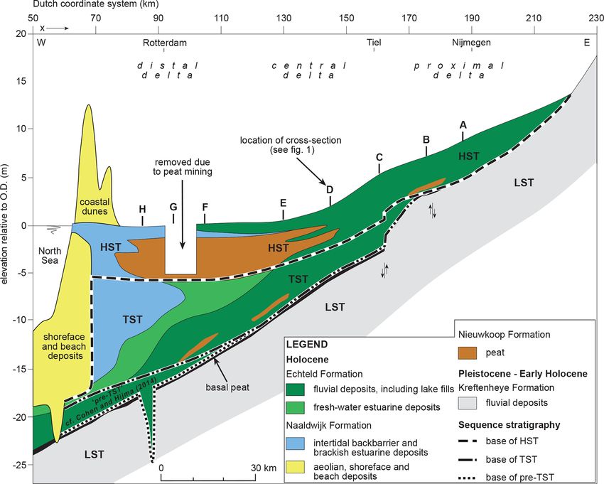
44                                      Marc J. P. Gouw and M. P. Hijma: From apex to shoreline: fluvio-deltaic architecture

ence alluvial architecture (e.g. Heller and Paola, 1996; Za-      extensive research over the past few decades has led to a
leha, 1997; Hajek and Wolinsky, 2012). Despite the elaborate      sound understanding of the factors that controlled the de-
work that has already been done, there are still two aspects      velopment of the delta (see Törnqvist, 1994; Berendsen and
of interest concerning alluvial-architecture research.            Stouthamer, 2000; Cohen, 2005; Gouw, 2007a; Hijma et al.,
   First, the majority of published alluvial-architecture stud-   2009; Stouthamer and Berendsen, 2000; Hijma and Cohen,
ies cover ancient (hard-rock) successions, often to provide       2011; Stouthamer et al., 2011), which can be used to explain
analogues for hydrocarbon-bearing formations (e.g. Aigner         alluvial architecture. Thus far, alluvial-architecture research
et al., 1996; Bridge et al., 2000; Dalrymple, 2001). A draw-      in the Rhine–Meuse delta has concentrated on the fluvial-
back of studying ancient successions is that they are typi-       dominated upstream half of the delta (Gouw, 2007a, 2008),
cally incomplete and/or deformed due to post-depositional         i.e. the proximal and central delta (for a definition of these
processes (erosion, faulting, compaction), which introduces       terms, see Stouthamer et al., 2011). For that area, Gouw
significant uncertainty in the interpretation of alluvial ar-     (2007a, 2008) reported a strong decrease in a downstream
chitecture. Furthermore, time control of ancient formations       direction of both the proportion of fluvial channel-belt sands
is usually poor, whereas adequate dating of the deposits is       within the succession (channel deposit proportion, CDP) and
needed to characterize the architecture of a fluvial succession   the degree to which channel-belt sand bodies are intercon-
(Bridge, 2003). Moreover, acquired datasets of ancient de-        nected (connectedness ratio, CR), largely because of the de-
posits are mostly of limited (palaeo)geographic extent. Most      crease of channel-belt sand body width relative to floodplain
alluvial-architecture research of ancient formations therefore    width. In this paper, new data from the lower reach of the
encompasses only a limited section of the larger fluvial sys-     Rhine–Meuse delta (distal delta) are evaluated, where ma-
tem or delta that the studied deposits are part of (e.g. Lopez-   rine and estuarine deposits intercalate with fluvial deposits,
Gomez et al., 2009; Jensen and Pedersen, 2010; Corbett            to test whether the calculated architectural relationships from
et al., 2011; York et al., 2011), meaning that the large-scale    upstream still hold.
transition from river valley to coastal plain (and associated        With this paper we aim to (1) present new alluvial-
backwater effects) is understudied, despite the fact that we      architecture data from the distal Rhine–Meuse delta, (2) dis-
know from modern systems that these effects are substantial       cuss the observed trends with specific attention to those in the
(Blum et al., 2013; Wu and Nitterour, 2020). Comprehensive        backwater zone, and (3) develop a function that describes the
studies covering the alluvial architecture on a delta scale are   delta-wide spatial trend in CDP based on the Rhine–Meuse
consequently scarce.                                              dataset to be used in the Rhine–Meuse delta and potentially
   The second point of interest in alluvial-architecture re-      in other deltas as well.
search is the constant need for – or chronic lack of – ar-
chitectural field data to aid (and enhance) geological mod-       2     Geological setting
elling. Modelling is commonly employed by geologists to
reconstruct and understand three-dimensional fluvial stratig-     The Rhine–Meuse delta is located in the south-east of the
raphy, for example to support reservoir characterization (see,    North Sea basin (Ziegler, 1994). To the north and south,
e.g. Bridge, 2008; Keogh et al., 2007) or model the distri-       undulating Pleistocene topography fringes the delta. Dur-
bution of sand resources (Maljers et al., 2015). Geological       ing the Quaternary, the Rhine and Meuse rivers repeatedly
models constantly need appropriate field data from a succes-      shifted their courses and main depocentres (e.g. Busschers
sion of interest, analogues and/or comparable modern fluvial      et al., 2007; Hijma et al., 2012). The delta apex region is cur-
systems to develop, test and/or improve the models. Partic-       rently located 150–160 km upstream of the present coastline
ularly high-resolution data from which spatial trends can be      (Stouthamer et al., 2011) in the basin hinge zone, while the
deduced are necessary to support geological modelling and         backwater length is 70–90 km (Berendsen, 1982; Fernandes
to enhance fundamental understanding of the alluvial archi-       et al., 2016). The paragraphs below first describe the evo-
tecture of (ancient) fluvial and fluvio-deltaic successions.      lution of the Rhine–Meuse delta during the Holocene. The
   The above-mentioned issues can be addressed by study-          alluvial architecture of the Rhine–Meuse delta is then exem-
ing the architecture of modern records. The main advan-           plified by showing parts of earlier published cross sections.
tage of studying modern fluvial successions is that they tend     The last paragraph summarizes our existing knowledge of
to be more complete than their ancient counterparts. The          the alluvial architecture of the proximal and central part of
Holocene Rhine–Meuse delta (Fig. 1) is especially suitable        the Rhine–Meuse delta.
for alluvial-architecture research because of the availability
of a large amount of subsurface data (Berendsen et al., 2007;
                                                                  2.1    Evolution and architecture of the Holocene
Cohen et al., 2012). The extensive Rhine–Meuse dataset in-
                                                                         fluvio-deltaic wedge
cludes lithological information from cores and cone pen-
etration tests (CPTs), detailed geological maps and cross         Last Glacial and Early Holocene fluvial sediments underlie
sections, and 14 C and other dates (optically stimulated lu-      the Holocene fluvio-deltaic wedge. These coarse and grav-
minescence (OSL), archaeological, historical). Furthermore,       elly sands have been deposited by precursors of the Rhine

Earth Surf. Dynam., 10, 43–64, 2022                                                  https://doi.org/10.5194/esurf-10-43-2022
Marc J. P. Gouw and M. P. Hijma: From apex to shoreline: fluvio-deltaic architecture                                                         45

Figure 1. Location of the Rhine–Meuse delta, the Netherlands. The cross sections used in this study are designated A–H: cross-sections A–E
are from Gouw and Erkens (2007), and sections F–H are from Hijma et al. (2009, modified). Definition of the proximal (x = 160–220 km),
central (x = 110–160 km) and distal delta (x = 70–110 km) is based on Stouthamer et al. (2011). The current delta apex is located ∼ 20 km
upstream of the Dutch–German border.

Figure 2. Schematic longitudinal section and sequence stratigraphy of the Holocene fluvio-deltaic wedge of the Rhine–Meuse delta (Hijma
and Cohen, 2011 modified). Sequence stratigraphic classification is from Hijma and Cohen (2011) and Cohen and Hijma (2014). The wedge
largely consists of a stacked succession of clastic fluvial deposits and organics (peat). Towards the coast, estuarine and intertidal sedimentary
lobes form the larger part of the wedge.

https://doi.org/10.5194/esurf-10-43-2022                                                            Earth Surf. Dynam., 10, 43–64, 2022
46                                        Marc J. P. Gouw and M. P. Hijma: From apex to shoreline: fluvio-deltaic architecture

Table 1. Chronostratigraphy and lithostratigraphy for the Holocene Rhine–Meuse delta. Chronostratigraphy for the Holocene follows Van
Geel et al. (1981), and chronostratigraphy for the Late Glacial follows Hoek (2008) and Rasmussen et al. (2006). Lithostratigraphy nomen-
clature is following Westerhoff et al. (2003).

and Meuse rivers (Busschers et al., 2007; Hijma et al.,                around 8.5 ka (note that all dates are in calendar years, unless
2009) (Kreftenheye Formation; Table 1) and are capped by               stated otherwise) and was driven by high rates of sea-level
a characteristic floodplain loam with palaeosol development            rise that caused rapid drowning of the fluvial valley (Fig. 1;
(Wijchen Member; Autin, 2008). Outside the palaeo-valley,              Hijma and Cohen, 2010, 2019) and the transformation to an
aeolian sedimentation prevailed until the earliest Holocene            estuary (Hijma and Cohen, 2011) at the start of the Middle
(Boxtel Formation). Relative sea-level rise after the Last             Holocene. An up to 5 m thick layer of freshwater fluvial–tidal
Glacial Maximum caused onlap and the formation of the                  and bay–head delta deposits (sand and clay) in the down-
fluvio-deltaic wedge (or “coastal prism”; see Posamentier              stream fluvio-deltaic wedge reflect these estuarine condi-
et al., 1992). The present Rhine–Meuse fluvio-deltaic wedge            tions. Further transgression caused sedimentation of marine
thickens in a western (downstream) direction to more than              intertidal deposits within a back-barrier environment. These
20 m near the North Sea coast and is composed of a stacked             back-barrier sediments reach up to ∼ 40 km inland from the
succession of clastic fluvial, estuarine and marine deposits           present coastline and mainly consist of an up to 5 m thick bed
intercalated with organic layers (Fig. 2). All Holocene clas-          of fine sand and silty and sandy clay (Figs. 1 and 2). Under
tic fluvial deposits in the fluvio-deltaic wedge belong to the         continuous but decelerating sea-level rise, fluvio-deltaic on-
Echteld Formation. This formation also includes freshwater             lap progressively moved inland, and by ∼ 5 ka net aggrada-
estuarine deposits (Hijma et al., 2009). Brackish estuarine            tion occurred practically all over the present delta (Berendsen
and marine deposits are grouped into the Naaldwijk Forma-              and Stouthamer, 2000; Cohen et al., 2002). The fluvial part of
tion. The organics are grouped into the separate Nieuwkoop             the wedge comprises numerous channel-belt sand bodies and
Formation.                                                             associated overbank deposits. The sand bodies consist of fine
   At the base of the Holocene, a near-continuous decimetre-           to coarse sand that is sometimes admixed with gravel. The
thick peat layer is found that reflects drowning of the pre-           overbank deposits include natural levee, crevasse-splay, flood
Holocene topography and has been used to determine the                 basin and lacustrine deposits. The natural levees (silty and
timing of fluvial-deltaic onlap (e.g. Jelgersma, 1961; Hijma           sandy clay) fringe their associated channel-belt sand bodies
and Cohen, 2011; Van De Plassche, 1982). Onlap started                 in 50–500 m wide zones and have typical thicknesses of 1–

Earth Surf. Dynam., 10, 43–64, 2022                                                       https://doi.org/10.5194/esurf-10-43-2022

Marc J. P. Gouw and M. P. Hijma: From apex to shoreline: fluvio-deltaic architecture                                              47

3 m near the channel-belt edges, with 4–5 m as a maximum.            2.2     Illustrative cross sections
The crevasse splays (sand, silty and sandy clay) cover an area
                                                                     Three transects illustrate the Holocene fluvio-deltaic succes-
of tens to hundreds of square kilometres each. The splays are
                                                                     sion of the Rhine–Meuse delta (Fig. 3). These transects (see
1–2 m thick, whereas the infill of crevasse channels is typ-
                                                                     Fig. 1 for their location) are modified fragments of the cross
ically twice as thick (Berendsen, 1982; Stouthamer, 2001;
                                                                     sections published earlier by Gouw and Erkens (2007, their
Weerts and Bierkens, 1993). Flood-basin deposits occur in
                                                                     cross sections A-A0 and D-D0 , also published in Gouw, 2008)
up to 5 m thick beds of massive clays. Additionally, flood-
                                                                     and Hijma et al. (2009, their cross-section B-B0 ). Below, the
basin lake fills are found, mostly on the distal delta plain. The
                                                                     characteristics of the Rhine–Meuse fluvio-deltaic architec-
lakes existed in remote flood basins between the active river
                                                                     ture are briefly described with the presented transects as typ-
channels. The lake fills are partly organic and partly clastic
                                                                     ical examples for the preserved succession in the proximal
(“organic-clastic lake fills”; see Bos, 2010) and are deposited
                                                                     (Fig. 3a), central (Fig. 3b) and distal (Fig. 3c) delta. For the
in up to 5 m thick beds. The lake sediments are largely of flu-
                                                                     original cross sections and elaborate descriptions thereof, we
vial origin (Bos, 2010).
                                                                     refer to the original papers (Gouw and Erkens, 2007; Hijma
   The clastic fluvio-deltaic deposits in the Rhine–Meuse
                                                                     et al., 2009). The calculations of the alluvial-architecture pa-
delta are intercalated with organic beds. The organics mainly
                                                                     rameters in this study are based on the full set of eight cross
consist of peat and form a significant part of the fluvio-deltaic
                                                                     sections, as displayed in Fig. 1.
wedge in the central and distal delta. Here, the organic beds
are up to 7 m thick. In contrast, organics are virtually ab-
sent in the proximal delta; only thin (< 1 m) isolated layers        2.2.1     Transect proximal delta
of peat are found here (Fig. 2). Large-scale aggradation in the      The succession of the proximal delta is characterized by rel-
Rhine–Meuse delta ceased around 1200 CE (∼ 0.75 ka) with             atively wide channel-belt sand bodies, thin beds of overbank
the embankment of the Rhine–Meuse distributaries (Berend-            deposits and small-scale occurrence of organics (Fig. 3a).
sen and Stouthamer, 2000). Presently, sedimentation only             The floodplain is fringed by Pleistocene uplands (Fig. 1)
takes place in the embanked floodplains along the modern             and is therefore of limited width (15–25 km). Gouw (2008)
Rhine and Meuse distributary channels.                               used this fact to explain the observed high interconnected-
   The Last Glacial and Early Holocene substrate of the              ness in this part of the delta; most sand bodies are intercon-
Rhine–Meuse palaeovalley forms the foundation of the                 nected, being up to 4300 m wide and 10 m thick. Addition-
Holocene succession. This is the lowstand systems tract              ally, all Holocene channel-belt sand bodies are connected to
(LST). Additionally, the earliest Holocene fluvial onlap sed-        the sandy Pleistocene substrate (LST). Up to 3 m thick beds
iments in the western delta are included in the LST (“pre-           of overbank deposits bound the channel-belt sand bodies.
transgressive systems tract”, pre-TST; see Cohen and Hi-             The overbank deposits are often underlain by a decimetre-
jma, 2014). In the distal delta plain, the TST comprises             thick peat layer, which reflects beginning of Holocene onlap.
brackish and freshwater estuarine sediments and intertidal
deposits formed in a back-barrier environment. Further up-
                                                                     2.2.2     Transect central delta
stream, fluvial, lacustrine and organic deposits formed in
permanently inundated flood basins, and extensive swamps             Contrary to the upstream situation, the channel-belt sand
are grouped in the TST. The upper boundary of the TST (or            bodies of the 50–60 km wide central delta are mostly not
base of the highstand systems tract, HST) in the distal delta        connected to another Holocene sand body, although a lim-
is marked by the onset of widespread peat formation, dated           ited number of interconnected channel-belt sand bodies ex-
at ∼ 6 ka (Hijma and Cohen, 2011). The HST in the distal             ist (Fig. 3b). The isolated channel-belt sand bodies are 100–
delta therefore largely consists of thick peat layers that have      1400 m wide and 5–7 m thick; the interconnected channel-
been partly mined. For the purpose of our calculations, the          belt sand bodies are up to 2600 m wide and 11 m thick.
original succession was reconstructed, i.e. the excavated ar-        The channel-belt sand bodies, ∼ 75 % of which make con-
eas were artificially refilled. In the central delta, clastic flu-   tact with the Pleistocene substrate, are encased in a 6–9 m
vial deposits and organics formed in periodically inundated          thick succession of overbank fines and organics. The over-
flood basins and small-scale swamps are part of the HST. In          bank beds within the succession are mostly 1–4 m in thick-
the proximal delta, the HST directly overlies the LST. The           ness. Organic layers are typically 0.5–2 m thick, although
TST is absent here because sediment delivery always out-             beds of 5 m thick are also found in areas with minimal fluvial
paced accommodation-space creation in this part of the delta         activity during the course of the Holocene (see, for example,
(Hijma and Cohen, 2011). The location of the downstream-             kilometres 25–27 in cross section D-D0 of Gouw and Erkens,
most cross section (H) marks the downstream end of our               2007, or cross-section D of Gouw, 2008).
study area; shoreface and beach deposits and coastal dunes
are not included in this study. See Fig. 1 for the location of
the longitudinal sections.

https://doi.org/10.5194/esurf-10-43-2022                                                     Earth Surf. Dynam., 10, 43–64, 2022
48 Marc J. P. Gouw and M. P. Hijma: From apex to shoreline: fluvio-deltaic architecture Figure 3. Transects showing typical fluvio-deltaic stratigraphy of the proximal (a), central (b) and distal (c) Holocene Rhine–Meuse delta (after Gouw and Erkens, 2007, and Hijma et al., 2009, modified). See Fig. 1 for the locations. Kilometre scale above each transect refers to the original cross sections. Note that 14 C dates are given in 14 C ka and that OSL dates are given in ka. See the text for a general description of the transects. Earth Surf. Dynam., 10, 43–64, 2022 https://doi.org/10.5194/esurf-10-43-2022
Marc J. P. Gouw and M. P. Hijma: From apex to shoreline: fluvio-deltaic architecture                                                49

2.2.3    Transect distal delta
The Holocene succession of the distal delta plain typically
consists of narrow channel-belt sand bodies and thick beds
of fluvial overbank deposits and organics (Fig. 3c). Further-
more, estuarine and back-barrier intertidal deposits are found
on the ∼ 75 km wide distal delta plain. Most channel-belt
sand bodies are not connected to another Holocene channel-
belt sand body. However, practically all Holocene channel-
belt sand bodies are attached to the underlying Pleistocene
sands. Channel-belt sand body width is typically between
100 and 600 m and is ∼ 1200 m at a maximum. The thick-
ness of the isolated channel-belt sand bodies ranges from 4
to 12.5 m and that of interconnected Holocene channel-belt
sand bodies is up to 17 m.
   The sand bodies are encased in an up to 15 m thick suc-
cession of fluvial overbank fines, estuarine deposits, organics
and intertidal back-barrier deposits. Most overbank deposits
are encountered in the lower half of the succession, roughly
below 6 m OD (Dutch Ordnance Datum). Hijma et al. (2009)
reckoned that a large part of these sediments are estuarine
in nature, deposited partly under freshwater and partly under
brackish conditions. The estuarine deposits are overlain by
a 1–3 m thick peat layer that is present throughout the distal
delta plain (e.g. Beets and Van Der Spek, 2000; Hijma et al.,
2009). Back-barrier intertidal flat deposits, dissected by tidal
channels, form the upper part of the fluvio-deltaic succession     Figure 4. Definition diagram showing geometric properties of flu-
of the distal delta. The sandy infill of these channels may be     vial channel-belt sand bodies (after Gouw, 2008, based on Mackey
over 25 m thick.                                                   and Bridge, 1995). A channel-belt sand body may be composed of
                                                                   either a single channel-belt sand body (simple channel-belt sand
2.3     Alluvial architecture of the proximal and central          body) or multiple interconnected channel-belt sand bodies (complex
        Rhine–Meuse delta                                          channel-belt sand body). The dimensions (SBW, SBT) of a simple
                                                                   channel-belt sand body are equal to the dimensions of the channel-
Gouw (2008, 2007a) studied the upstream half of Rhine–             belt sand body (w, t) that constitutes the simple sand body (a). In
Meuse fluvio-deltaic wedge (Fig. 2) and highlighted two as-        cases of complex channel-belt sand bodies, SBW and SBT may be
pects of alluvial architecture: (1) geometry of channel-belt       significantly larger than the dimensions of the individual channel-
sand bodies and (2) spatial and temporal trends in alluvial        belt sand bodies that are part of the complex sand body (b). Calcula-
                                                                   tion of the connectedness ratio (CR) is schematically shown in (c).
architecture.

2.3.1    Geometry of channel-belt sand bodies                      6.7 m on average. It was shown that the width / thickness ra-
The geometry of a channel-belt sand body is usually charac-        tio of simple channel-belt sand bodies may decrease by a
terized by the ratio between its width (SBW) and thickness         factor of 4 to 6.5 in a downstream direction, mainly due to
(SBT): the sand body width / thickness ratio (SBW/SBT).            narrowing of the sand bodies (Gouw and Berendsen, 2007).
In this paper, the term “channel-belt sand body” refers to a       SBW and SBT of complex channel-belt sand bodies may be
sand body formed by a single or multiple river channels. A         significantly larger than those of simple channel-belt sand
channel-belt sand body can either be the sand body of a sin-       bodies (Fig. 4). SBW of complex channel-belt sand bod-
gle channel belt (referred to as a “simple sand body”) or be       ies varies between 1400 and 4300 m, and SBT ranges from
composed of multiple interconnected (amalgamated) chan-            5.2 to 10 m (Gouw, 2008). As with simple channel-belt sand
nel belts (“complex sand body”) (Fig. 4). Major factors in         bodies, SBW/SBT of complex channel-belt sand bodies de-
determining the size of a channel-belt sand body are lateral       creases downstream.
migration rates of the channels and channel-belt longevity
(see Sect. 5).
   On the Rhine–Meuse delta plain, the width of simple
channel-belt sand bodies varies between 40 and 3200 m.
Their thickness typically ranges between 5 and 9 m and is

https://doi.org/10.5194/esurf-10-43-2022                                                   Earth Surf. Dynam., 10, 43–64, 2022
50 Marc J. P. Gouw and M. P. Hijma: From apex to shoreline: fluvio-deltaic architecture
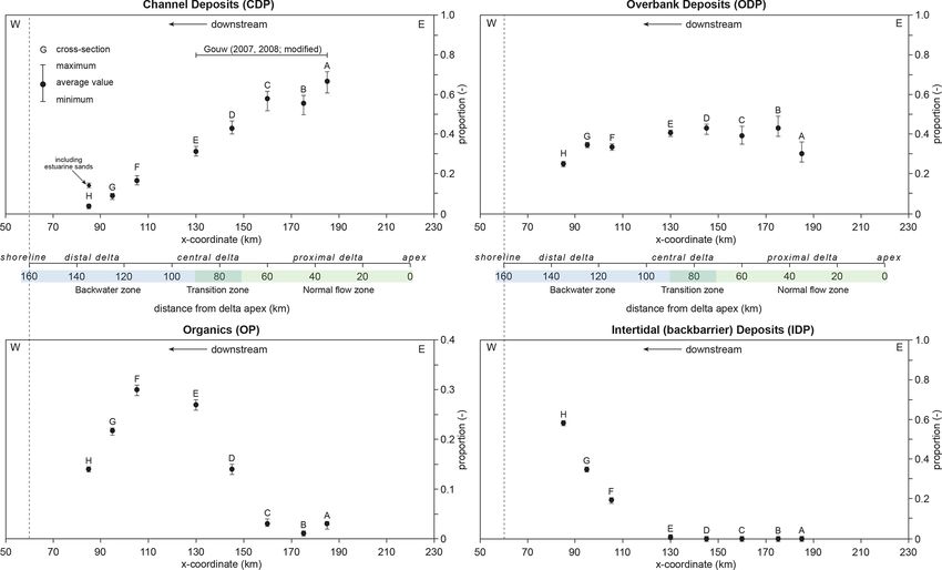
2.3.2 Previously established spatial and temporal trends general flow direction (towards the west) and (3) are dis-
in alluvial architecture for the proximal and central tributed evenly over the study area as much as possible. Bore-
delta hole spacing along the cross sections is ∼ 100 m on aver-
age. For details on the applied research methods and acquired
Gouw (2008, 2007b) found distinct spatial trends in the al- field data, the authors refer to Gouw and Erkens (2007) and
luvial architecture of the proximal and central Rhine–Meuse Hijma et al. (2009).
delta: (1) the proportion of channel deposits (CDP) decreases From the sections, parameters that characterize alluvial
in a downstream direction; (2) concurrent to CDP, the con- architecture were computed (cf. Gouw, 2008): (1) channel-
nectedness between channel-belt sand bodies (CR) also de- belt sand body geometry, (2) alluvial-architecture propor-
creases; (3) contrary to CDP, the organics proportion (OP) tions and (3) connectedness ratio. For cross-sections A–
increases in a downstream direction; and (4) the propor- E, values for these alluvial-architecture parameters have al-
tion of overbank deposits (ODP) is more or less constant ready been published (Gouw, 2008, 2007a), although some
throughout the proximal and central delta plain. These spatial have changed slightly after lengthening of the cross sections.
trends in alluvial architecture are attributed to variations in The architectural parameters for cross sections F–H are new
available accommodation space, channel-belt sand body size calculations. The original cross sections were converted to
and floodplain geometry (Gouw, 2007a, 2008). For instance, include four basic units: (1) fluvial channel-belt deposits,
CDP and CR are relatively high where floodplain width is (2) fluvial overbank deposits, (3) organics and (4) intertidal
limited, meaning that the inherited floodplain width is an im- (back-barrier) deposits. The units were further subdivided
portant factor for CDP. into sands and fines, after which the alluvial-architecture pa-
It was found that the alluvial architecture of the cen- rameters were calculated as described below.
tral delta also varies with the age of the succession. CDP
and CR for the succession formed before 3 ka appear to be
lower than for the post-3 ka succession. These temporal vari- 3.1 Channel-belt sand body geometry
ations in alluvial architecture are mainly related to chang- The method of Gouw (2008) was followed to determine the
ing sand body geometry because channel-belt sand bodies width and thickness of each channel-belt sand body in the
in the post-3 ka succession are significantly wider than those eight cross sections (Fig. 4). Channel-belt sand body width
in the pre-3 ka succession. Furthermore, the interaction be- could be readily determined within 100 m for relatively wide
tween aggradation rate and avulsion frequency may have in- (≥ 250 m) channel-belt sand bodies and within 50 m for nar-
fluenced alluvial architecture: CDP appears to be higher dur- row ones (≤ 100 m). However, data on channel-belt sand
ing periods of high local (i.e. natural levee) to regional (i.e. body thickness were relatively scarce. Exact thickness data
flood basin) aggradation rates and high avulsion frequencies were established for 40 % of the sand bodies crossed. When
(Gouw, 2008; Stouthamer et al., 2011). This means that the channel-belt sand body thickness was unknown, averages
rate of accommodation-space creation, in addition to inher- from Gouw and Berendsen (2007) were used as a substi-
ited floodplain width, is an important factor for CDP (see tute. They found a thickness of 6.7 ± 1.5 m (average ± 1σ )
Sect. 5). for individual Rhine channel-belt sand bodies in the proxi-
The architectural trends described above are valid for the mal and central delta. Comparison with available field data
proximal and central Rhine–Meuse delta. In this study, new showed that these values are realistic for the distal delta as
data from the distal delta are incorporated in order to extend well (Fig. 3c). The 1σ values were applied as margins of
our knowledge of the alluvial architecture of the preserved error in the calculations of the alluvial-architecture propor-
Rhine–Meuse fluvio-deltaic wedge, including the increasing tions.
influence of backwater morphodynamics.
3.2 Alluvial-architecture proportions
3 Methods
For all cross sections, the proportion of fluvial channel de-
Eight cross-valley geological sections (designated A–H; posits (CDP), overbank deposits (ODP) and organics (OP)
Fig. 1) were used to determine alluvial architecture. These were determined. In the distal delta, fluvial channel-belt sand
cross sections were previously published by Gouw and bodies merge into estuarine sand bodies (Hijma et al., 2009).
Erkens (2007) and Hijma et al. (2009), whereby the Hijma The fluvial channel-belt sands and estuarine sands (notably
et al. (2009) sections were slightly extended to capture the bay-head delta deposits; Hijma et al., 2009) in cross-section
Holocene fluvio-deltaic wedge for as much as possible. The H were therefore lumped together to calculate CDP. Addi-
sections were constructed with approximately 2800 bor- tionally, the proportion of intertidal deposits (IDP) was cal-
ings, 724 cone penetration tests (CPTs), 278 14 C dates and culated for the sections in the distal delta. Proportion val-
16 OSL dates. The location of the sections was chosen such ues were calculated relative to the total area of the Holocene
that they (1) capture the Holocene fluvio-deltaic succession fluvio-deltaic succession in each cross section (cf. Mackey
as much as possible, (2) are orientated perpendicular to the and Bridge, 1995). For example, ODP is the cross-sectional
Earth Surf. Dynam., 10, 43–64, 2022 https://doi.org/10.5194/esurf-10-43-2022Marc J. P. Gouw and M. P. Hijma: From apex to shoreline: fluvio-deltaic architecture 51
Table 2. Dimensions of the channel-belt sand bodies in the cross sections. Average (av), minimum (min) and maximum (max) values for the
channel-belt sand body dimensions are given for each section.
Cross section Number Simple: With SBW (m) SBT3 (m) SBW/SBT3 (–) Data source4
of sand complex1 estimated Av Min Max Av Min Max Av Min Max
bodies thickness2
A 3 3 2823 1385 4281 8.4 6.7 9.3 344 152 460 a, b
B 11 8:3 10 999 63 3728 7.3 2.6 11.7 108 16 319 a, b
C 13 9:4 13 923 163 4480 7.9 6.7 14.0 97 24 320 a, b
D 28 22 : 6 20 727 93 2624 7.1 4.0 11.0 93 15 257 a, b
E 31 25 : 6 13 582 70 2458 7.3 5.0 12.9 75 11 283 a, b
F 29 26 : 3 17 547 82 2033 9.0 6.7 16.9 67 9 303 c, this paper
G 27 24 : 3 9 366 98 1488 7.4 3.5 17.1 49 16 140 c, this paper
H 10 8:2 4 530 133 1428 7.3 3.3 13.0 70 18 123 c, this paper
1 Number of simple sand bodies versus complex ones. For definitions, see the main text. 2 Number of sand bodies with an estimated thickness. When channel sand body thickness
was unknown, data from Gouw and Berendsen (2007) were used as an estimate. See the main text for explanation. 3 Data presented are for the case wherein a thickness of 6.7 m is
taken as an estimate for channel sand bodies with an unknown base (cf. Gouw and Berendsen, 2007). 4 Data sources are as follows: “a” refers to Gouw and Erkens (2007), “b” refers
to Gouw (2007a, 2008) updated, and “c” refers to Hijma et al. (2009).
area of all overbank deposits divided by the total cross- The downstream-decreasing trend in channel-belt sand
sectional area. An ODP of 0.40 implies that 40 % of the suc- body width / thickness ratio, as established for the proximal
cession consists of overbank deposits. and central Rhine–Meuse delta (Gouw, 2008), more or less
The total sand proportion of each section was also cal- continues in the distal delta (Fig. 5; note that shown band-
culated. Total sand proportion is defined as the sum of flu- widths represent min–max values, not confidence intervals).
vial channel-belt sands, sands in crevasse splays and lake The highest SBW/SBT averages (344 in section A and 108 in
deposits (“coarse-grained overbank deposits”; see Bos and section B) are found in the proximal delta, whereas values
Stouthamer, 2011), estuarine sands, and sandy intertidal de- of less than 70 are found downstream. In other words, aver-
posits (“tidal channel deposits” of Hijma et al., 2009). The age SBW/SBT in the proximal delta is up to 5 times higher
proportions of these sands are calculated similarly to the than average SBW/SBT in the distal delta. This downstream-
other alluvial-architecture parameters described above. decreasing trend is attributed to the decrease in channel-
belt sand body width because sand body thickness is near-
3.3 Connectedness ratio constant over the study area (Table 2).
The connectedness ratio (CR) is the summed length of hori-
zontal contact between channel-belt sand bodies divided by 4.2 Alluvial-architecture proportions
the summed width of all channel-belt sand bodies in each
cross section (Gouw, 2008; cf. Mackey and Bridge, 1995) The alluvial-architecture proportions show prominent spatial
(Fig. 4). The connectedness ratio is given as a fraction. For trends (Fig. 6). First, the proportion of fluvial channel-belt
example, a CR of 0.50 implies that half the sand body width deposits (CDP) strongly decreases in a downstream direc-
is connected to another channel-belt sand body. tion. It measures ∼ 0.70 in the proximal delta (cf. Gouw,
2008) and diminishes to 0.04 downstream. This implies that
4 Results the amount of fluvial channel-belt sands in the distal delta is
just 5 % of the amount in the proximal delta. In the succes-
4.1 Channel-belt sand body geometry sion of the distal delta, however, fluvial channel-belt sands
blend seamlessly into estuarine bay–head sands (Hijma et al.,
Geometric data for the channel-belt sand bodies in the cross- 2009). Taking this into account, CDP including estuarine
sections are summarized in Table 2 and Fig. 5. Average sands is ∼ 0.15 in the downstream-most cross section (Fig. 6;
channel-belt sand body width decreases in a downstream di- Table 3).
rection, from more than 1000 m upstream to ca. 500 m down- The proportion of overbank deposits (ODP) is more or
stream (Table 2). The exceptionally high value (2823 m) for less constant (0.4) in the larger part of the study area (cf.
cross-section A is due to the presence of three relatively wide Gouw, 2008; Bos, 2010). The graph for the organics propor-
sand bodies in that section (Gouw, 2008). Average channel- tion (OP) reveals a distinct peak (0.30) in the transition zone
belt sand body thickness is practically constant throughout from the central to the distal delta. From this point down-
the study area (7–8.5 m) (Table 2). stream, OP clearly decreases to 0.14. This trend corresponds
to the appearance of intertidal deposits in the distal delta
https://doi.org/10.5194/esurf-10-43-2022 Earth Surf. Dynam., 10, 43–64, 202252 Marc J. P. Gouw and M. P. Hijma: From apex to shoreline: fluvio-deltaic architecture
Figure 5. Average width / thickness ratios (SBW/SBT) as calculated for each cross section. The ranges result from applying a thickness of
5.2, 6.7, and 8.2 m (average ± 1σ ) for channel-belt sand bodies with an unknown thickness (Gouw, 2008; cf. Gouw and Berendsen, 2007).
The data records in this paper are plotted against the x coordinate because general flow direction is towards the west, which makes the
x coordinate a suitable measure for downstream distance. Average SBW/SBT decreases with downstream distance from the delta apex. Data
for sections A–E is updated from Gouw (2008, 2007a).
Table 3. Data on the total sand proportion (TSP) and its contributors for the Rhine–Meuse fluvio-deltaic wedge. Proportions are relative to
the total Holocene fluvio-deltaic succession. Percentages are relative to the total sand proportion.
Proportions relative to total Holocene succession (–) Percentage of total sand proportion (%)
Cross Relative Total Fluvial Fluvial Estuarine Intertidal Fluvial Fluvial Estuarine Intertidal
section distance from sand channel- overbank sands3 back- channel- overbank sands back-
delta apex proportion belt sands2 barrier belt sands barrier
d/D (–) (–)1 sands sands4 sands sands
A 0.23 0.70 0.67 0.03 0 0 95.7 4.3 0 0
B 0.30 0.59 0.56 0.03 0 0 94.9 5.1 0 0
C 0.40 0.62 0.58 0.04 0 0 93.5 6.5 0 0
D 0.50 0.46 0.43 0.03 0 0 93.1 6.9 0 0
E 0.60 0.34 0.31 0.03 0 0 90.4 9.6 0 0
F 0.77 0.22 0.17 0.01 0 0.04 76.2 5.8 0 17.9
G 0.83 0.18 0.09 0.02 0 0.07 50.0 11.1 0 38.9
H 0.90 0.35 0.04 0.01 0.10 0.19 11.4 5.7 28.6 54.3
Total wedge n/a 0.41 0.36 0.03 < 0.01 0.02 86.8 6.2 1.3 5.7
1 Total sand proportion is the sum of fluvial channel sands (CDP), fluvial overbank sands, estuarine sands and marine sands. 2 Sands in crevasse splays and lake deposits (“coarse-grained overbank
deposits”; see Bos and Stouthamer 2011). 3 Notable bay–head delta deposits (Hijma et al., 2009); data are from Bos and Stouthamer (2011). 4 Sandy intertidal deposits, mainly tidal channel fills.
n/a stands for not applicable.
succession. The proportion of intertidal back-barrier deposits of sand. The total sand proportion generally decreases with
(IDP) rapidly increases coastward to a maximum of 0.58 in downstream distance from the delta apex, with the lowest
the downstream-most section. value in cross section G (Fig. 7, Table 3). This trend is re-
versed in the downstream-most cross-section where intertidal
back-barrier and estuarine sands dominate. Here, total sand
4.3 Total sand proportion proportion amounts to 0.35.
Our data demonstrates that, except for the near-coastal
The total sand proportion varies between 0.18 and 0.70 (Ta- area, the bulk of the sand is fluvial channel-belt sand, despite
ble 3) and is 0.41 for the wedge as a whole. In other words, its decreasing proportion relative to the total Holocene suc-
41 % of the Rhine–Meuse fluvio-deltaic wedge is composed
Earth Surf. Dynam., 10, 43–64, 2022 https://doi.org/10.5194/esurf-10-43-2022Marc J. P. Gouw and M. P. Hijma: From apex to shoreline: fluvio-deltaic architecture 53
Figure 6. Proportions of channel deposits (CDP), overbank deposits (ODP), organic matter (OP) and intertidal deposits (IDP) as established
for the cross sections. Ranges are as in Fig. 5. CDP clearly decreases in a downstream direction, whereas ODP is near-constant in the larger
part of the Rhine–Meuse delta. OP peaks in the central-to-distal-delta transition zone and subsequently decreases coastward. This decrease
is associated with a steep increase in the proportion of intertidal back-barrier deposits (IDP), which is 0.6 at a maximum in our study area.
Data for sections A–E is slightly modified from Gouw (2008, 2007a). Note the different vertical scale for the OP graph.
cession (Table 3). In the proximal and central delta, fluvial tion as suggested in modelling studies (Bridge and Mackey,
channel-belt sands constitute 75 %–95 % of the total sand 1993b; Mackey and Bridge, 1995). Our data show that CR in-
proportion, whereas in the distal delta it drops to approxi- stantly doubles as CDP rises above 0.5. Two CR populations
mately 10 %. Overall, fluvial channel-belt sands form 87 % divided by the CDP = 0.5 vertical are therefore recognized:
of all sands in the wedge. The contribution of fluvial over- CR ≥ 0.2 for CDP ≥ 0.5 and CR ≤ 0.1 for CDP < 0.5. This is
bank sands to the total sand proportion is relatively constant in accordance with previously published data (Gouw, 2008).
and ranges between 4.3 % and 11.1 % (6 % overall). Estu- All Holocene channel-belt sand bodies in the proximal
arine and intertidal sands dominate in the downstream-most delta are connected to the sandy Early Holocene–Pleistocene
section H, where they form 28.6 % and 54.3 %, respectively, (lowstand) substrate. In the central delta, 75 %–80 % of
of the total sand proportion (Table 3). the channel-belt sand bodies make contact. This figure
rises in the distal delta, where approximately 90 % of the
Holocene channel-belt sand bodies are connected to the Early
4.4 Connectedness Holocene–Pleistocene substrate. This is due to the fact that
most fluvial channel-belt sand bodies in the distal delta are
The connectedness ratio (CR) of fluvial channel-belt sand
encountered in the lower half of the Holocene succession (see
bodies is roughly 3 times higher in the proximal delta than
Fig. 3c).
in the distal delta (Fig. 8). CR is calculated at ∼ 0.25 in
cross sections A–C and ∼ 0.08 in cross sections D–H, with a
minimum of 0.03 (cross section F) and a maximum of 0.30 5 Discussion
(cross section C).
Channel-belt sand body interconnectedness increases with The above sections dealt with the first aim of this paper,
the proportion of channel-belt sands in the succession namely presenting new alluvial-architecture data from the
(Fig. 8), although it is not a positive (curvilinear) correla- distal Rhine–Meuse delta. The second aim concerns a dis-
https://doi.org/10.5194/esurf-10-43-2022 Earth Surf. Dynam., 10, 43–64, 202254 Marc J. P. Gouw and M. P. Hijma: From apex to shoreline: fluvio-deltaic architecture
Figure 7. Diagram showing the contributors to the total sand proportion for each cross section. The total sand proportion is the sum of fluvial
channel-belt sands, coarse-grained overbank deposits in crevasse splays and lake deposits (cf. Bos and Stouthamer, 2011), estuarine sands
(notably bay–head delta deposits; Hijma et al., 2009), and sandy back-barrier intertidal deposits. In the upstream delta, most sand is stored
in fluvial channel-belt sand bodies. In contrast, most sand in the downstream delta is estuarine and intertidal in nature.
cussion of the observed trends, with specific attention to delta apex. To assist with this, a causal loop diagram is
the backwater zone. We start this discussion with the iso- presented to visualize the interrelations between factors in-
lation of the main drivers that determined the alluvial ar- volved (Fig. 10). Because many of these factors have been
chitecture (with focus on CDP) of the Rhine–Meuse delta extensively elaborated in previous publications, e.g. Cohen
(Sect. 5.1) and then highlight the specific trends for the back- et al. (2002), Gouw and Berendsen (2007), Gouw and Erkens
water zone (Sect. 5.2). Section 5.3 addresses the third aim (2007), and Stouthamer et al. (2011), this discussion concen-
and presents a function that describes the delta-wide spatial trates on subjects that in our opinion have been overlooked
trend in CDP based on the Rhine–Meuse dataset to be used or insufficiently highlighted before, specifically channel-belt
in the Rhine–Meuse delta and potentially in other deltas as longevity, tidal influence, and the ratio between channel-belt
well. Section 5.4 discusses potential applications of alluvial- sand body width and floodplain width.
architecture research.
5.1.1 Variable 1: channel-belt sand body size
5.1 Drivers of alluvial architecture in the Rhine–Meuse
Field studies (e.g. Bridge et al., 2000; Gouw, 2008) demon-
delta
strated that channel-belt sand body size strongly controls the
In Sect. 4 it was shown that CDP clearly decreases in a down- proportion of channel-belt sands in the succession. Channel-
stream direction (Fig. 6). When CDP is plotted against the belt sand body size is related to three variables: lateral mi-
downstream distance from the delta apex (Fig. 9) a strong gration rate of formative channels, channel-belt longevity
inverse relationship emerges. It thus seems that the propor- and channel size (Fig. 10). Geometrically, channel-belt sand
tion of channel-belt sands can be estimated using the dis- body size is largely determined by its width because sand
tance from the delta apex. To assess whether this could body width is far larger than sand body thickness (Bridge
also hold for other deltas, the key factors driving the rela- et al., 2000; Gibling, 2006; Gouw and Berendsen, 2007).
tionship should be understood. Below, the two variables of Sand body width increases with lateral migration rate and
CDP – channel-belt sand body size and size of the Holocene longevity of the formative channel. Initially, Gouw and
fluvio-deltaic wedge (Bridge and Mackey, 1993b; Mackey Berendsen (2007) attributed the high width / thickness ra-
and Bridge, 1995) – are unravelled to identify key factors tios in the upper Rhine–Meuse delta (see Fig. 5) to high lat-
for the relationship between CDP and distance from the eral migration rates of channels only. They hypothesized that
Earth Surf. Dynam., 10, 43–64, 2022 https://doi.org/10.5194/esurf-10-43-2022Marc J. P. Gouw and M. P. Hijma: From apex to shoreline: fluvio-deltaic architecture 55 Figure 8. (a) CR as established for the cross sections and (b) CR plotted against CDP. CR decreases in a downstream direction. The high value for cross-section C is due to the presence of an exceptionally large complex channel-belt sand body. CR is significantly higher when CDP exceeds 0.5 (cf. Gouw, 2008). Data for cross-sections A–E are from Gouw (2007a, 2008). these high lateral migration rates were caused by high sub- formative channel has had more time to widen its associated soil erodibility (sandy subsoil) and high stream power (high sand body. Using the new dataset it is clear that this theory channel gradient). They discussed that both bank erodibility is also applicable to the Rhine–Meuse delta (Fig. 11). This and stream power decrease in a downstream direction – the is probably best exemplified in the central delta, where chan- former because of an increase of erosion-resistant bank ma- nel belts with the longest period of activity are generally the terial in the subsoil (thick layers of massive clay and peat; widest, despite the fact that many are encased in cohesive see Fig. 4b), the latter mainly because of decreasing river deposits (see Fig. 3b). The lifespan of the formative chan- gradients in the backwater length (e.g. Blum et al., 2013; nels was apparently of sufficient length to enable widening Nittrouer et al., 2012) – which reduces channel lateral mi- of their associated sand bodies, although channel migration grations rates and thereby sand body width, width / thickness would have been hampered by cohesive banks. This suggests ratios and CDP (see Figs. 5 and 6). that the factor “channel-belt longevity” overpowers the fac- Although lateral migration rates do play a major role, tor “subsoil erodibility” for channel-belt sand body width, Gouw and Berendsen (2007) overlooked channel-belt at least in the central delta. This effect is probably also in longevity, the second factor influencing channel-belt sand place in the proximal delta, although it is less obvious due body size (Fig. 10). There is general consensus (as illustrated to easily erodible sediments (sand) in the shallow subsur- in Karssenberg and Bridge, 2008, for example) that high face favouring high channel migration rates. Most channel channel-belt longevity favours wide sand bodies because the belts in the proximal delta have been active for several thou- https://doi.org/10.5194/esurf-10-43-2022 Earth Surf. Dynam., 10, 43–64, 2022
56                                          Marc J. P. Gouw and M. P. Hijma: From apex to shoreline: fluvio-deltaic architecture

Figure 9. Relationship between CDP and downstream distance
from the delta apex. Distance is noted relative to the total distance
between the delta apex and the shoreline (relative distance d/D,
with d being downstream distance from delta apex and D total dis-
tance between delta apex and shoreline). The derived linear function
suggests a CDP of ∼ 0.9 near the delta apex (d/D = 0). CDP is at
a minimum (0.10–0.15) in the distal delta (d/D > 0.8).

sands of years (Berendsen and Stouthamer, 2000; Berendsen
et al., 2007; Cohen et al., 2012), which is relatively long com-
pared to the delta average (ca. 1000 years; Berendsen and               Figure 10. Causal loop diagram displaying the interrelated vari-
Stouthamer, 2002). The channels thus had abundant time to               ables for CDP. A plus sign indicates a positive relationship between
                                                                        variables (variables change in the same direction), and a minus sign
form wide sand bodies, amplified by the easily erodible sub-
                                                                        indicates a negative relationship. CDP is calculated with two vari-
soil (see Fig. 3a), which explains why the channel-belt sand            ables (marked in green boxes): channel-belt sand body size and size
bodies in the proximal fluvial delta are significantly wider            of the fluvio-deltaic wedge. These in turn are largely determined by
(∼ 900 m on average) than the delta average (∼ 550 m). In               channel lateral migration rate, channel-belt longevity, accommoda-
short, it seems that there is a positive correlation between            tion space and inherited floodplain geometry (width and topogra-
channel-belt longevity and channel-belt sand body width –               phy) for which they are considered the key driving factors (green-
and thus width / thickness ratios and CDP – in our study area.          blue boxes) explaining the relationship between CDP and down-
   Gouw and Berendsen (2007) argued that in the proxi-                  stream distance from delta apex. See the text for a discussion of this
mal and central delta subsoil erodibility is probably domi-             relationship.
nant over stream power in explaining the downstream de-
crease in lateral migration and thereby sand body width. It
is suspected that the situation in the distal delta is more
complicated because of the interplay between fluvial and
tidal processes (cf. Dalrymple and Choi, 2007) and the im-
pact of backwater effects (Blum et al., 2013). In the fluvial-
dominated (upstream) part of the distal delta, fluvial-channel
gradients and discharge per river channel, the two compo-
nents of stream power, are both low. Channel gradients ap-
proach zero, whereas discharge is divided over multiple river
courses causing discharge per river course to be minimal.
The resultant stream power per river channel is therefore
extremely low, leading to little lateral migration and con-             Figure 11. Relationship between channel-belt width (w) and du-
sequently narrow sand bodies. In addition, as the energy to             ration of channel activity (longevity). The graph shows a fairly
transport sediment decreases, the average grain size of the             strong positive correlation (r = 0.671), which implies that channel-
fluvial sand bodies decreases in concordance and suspended              belt width generally increases with longevity. Data are from 110 se-
                                                                        lected Rhine–Meuse channel belts with a well-established longevity
sediment concentrations rise. The latter reach a maximum
                                                                        (cf. Cohen et al. 2012) and width (this study).
somewhere in the fluvial–marine transition zone (in our study
area, this would be around the x = 100 coordinate). Further
downstream in the distal delta, tidal currents become increas-

Earth Surf. Dynam., 10, 43–64, 2022                                                         https://doi.org/10.5194/esurf-10-43-2022
Marc J. P. Gouw and M. P. Hijma: From apex to shoreline: fluvio-deltaic architecture 57
ingly important. The tidal currents start to take over the role experiencing relative base-level rise and increasing aggra-
of transporting sediment, which leads to a drop in suspended dation rates in a downstream direction (Cohen, 2005; Van
sediment rates and increase in average grain size (e.g. Dal- Dijk et al., 1991; Cohen et al., 2005). As a result, the pre-
rymple and Choi, 2007). Moreover, tidal water fluxes through served Holocene fluvio-deltaic wedge thickens seaward (see
the channels increase seaward, i.e. discharge per channel in- Fig. 2). Because the wedge also widens, its volume increases
creases due the influx of tidal waters. The increased dis- strongly in a downstream direction. This geometry is typi-
charge causes channel enlargement and rising stream power, cal for the Rhine–Meuse delta, and it should be noted that
which likely leads to increased sand body width. Addition- the geometry – and architectural patterns – of fluvio-deltaic
ally, bank erodibility probably increases in the distal delta wedges varies, for example, with the direction of basin sub-
due to a decrease of erosion-resistant peat layers in the sub- sidence (fore-tilted versus back-tilted basins) (e.g. Heller and
soil (see Fig. 6, OP graph) in favour of immature subaque- Paola, 1996). Two factors with regard to the geometry of
ous silt-laminated tidal clays and silty-sandy bay–head delta the Rhine–Meuse fluvio-deltaic wedge are briefly discussed:
sediments that are easily erodible (Hijma and Cohen, 2011; (1) creation of accommodation space, which mainly provides
Hijma et al., 2009). In the Rhine–Meuse delta peat layers room for vertical expansion (thickening), and (2) the inher-
have an important influence on lateral migration, more so ited floodplain topography, which mainly influences horizon-
than in most other deltas where in absence of thick peat se- tal expansion (widening) (Fig. 10).
quences cohesive muds can play an important role (Edmonds A principal prerequisite for the preservation of any flu-
and Slingerland, 2010; Dunne and Jerolmack, 2018). The vial succession is the availability of accommodation space,
presence of these soft clays and silts in the subsoil in combi- which is defined as the available space to store sediments
nation with a decrease of resistant peat expectedly caused a (Blum and Törnqvist, 2000). Accommodation space in the
decrease in bank resistance or, in other words, an increase in Rhine–Meuse delta has been created by relative base-level
bank erodibility. This favours lateral migration and thereby rise, which in turn is driven by two key processes: absolute
sand body width. In short, based on the above, it can be ex- sea-level rise and land subsidence (Cohen, 2005; Gouw and
pected that the proportion of channel-belt sands decreases Erkens, 2007; Hijma et al., 2009; for elaborate discussions,
downstream in the fluvial-dominated part of deltas, reaching see Van Dijk et al., 1991) (Fig. 10). The rate at which ac-
a minimum in the fluvial–marine transition zone, and then commodation space was created in the Rhine–Meuse delta
stabilizes or even increases again in a seaward direction. This increased in a downstream direction (Cohen, 2005), as it
is exactly what is found in the data of this study (see Fig. 6a). does in most deltas with an apex in the basin hinge zone
Channel size is the third factor influencing channel-belt and a basin-ward depocentre. This enabled vertical expan-
sand body dimensions (Fig. 10). Channel size certainly influ- sion of the wedge and downstream thickening of the pre-
ences sand body size because channel depth determines min- served fluvio-deltaic succession. In the central delta, cre-
imum channel-belt sand body thickness and channel width is ation of accommodation space outpaced sediment delivery,
a minimum for channel-belt sand body width (see Gouw and causing an increase in organics within the succession (see
Berendsen, 2007) provided that the channel is filled in with Fig. 6c). In the distal delta, the rate of accommodation space
sandy bar deposits. Whereas channel-belt sand body thick- creation was even larger, but the space was mainly filled in
ness roughly reflects channel depth, channel-belt sand bodies with intertidal and estuarine muds behind a coastal barrier
are mostly far wider than the width of its associated channel that formed from ∼ 7.5 ka onwards. Actually, the end posi-
(Allen, 1965; Fisk, 1944; Bridge, 2003). Gouw and Berend- tion of this coastal barrier also determined the dimensions of
sen (2007), for example, reported sand body width to channel the preserved fluvio-deltaic wedge as it forms its downstream
width ratios of 6 to 10 for the modern Rhine and Meuse dis- end (Hijma et al., 2009, 2010; Hijma and Cohen, 2011).
tributaries. In addition, they found significant variation in the The inherited floodplain topography affected the dimen-
ratio between sand body width and channel width. In other sions of the Rhine–Meuse fluvio-deltaic wedge because bor-
words, although channel width can be considered as a min- dering Pleistocene uplands in the proximal delta (Fig. 1) limit
imum for sand body width, it has a weak relation with the floodplain width. These uplands are absent further down-
resultant sand body size. Therefore, channel size is not re- stream, which made horizontal expansion of the wedge pos-
garded as a key factor for channel-belt sand body size or sible. Because the amount of created accommodation space
CDP. in the central and distal delta was indeed sufficient to en-
able enlargement of the wedge, the cross-sectional area of
5.1.2 Variable 2: dimensions of the Holocene
the fluvio-deltaic wedge increases downstream. The down-
fluvio-deltaic wedge
stream enlargement of the wedge yields relatively low CDP
values, as observed in the field data (Fig. 6a).
The dimensions of the fluvio-deltaic wedge influences CDP
because its cross-sectional area is the denominator in the
CDP calculations (cf. Mackey and Bridge, 1995). The
Rhine–Meuse delta is a typical example of a fluvial system
https://doi.org/10.5194/esurf-10-43-2022 Earth Surf. Dynam., 10, 43–64, 2022You can also read