Morphodynamic conditions of heavy metal concentration in deposits of the Vistula River valley near K ępa Gostecka (central Poland)
←
→
Page content transcription
If your browser does not render page correctly, please read the page content below
Open Geosciences 2020; 12: 1036–1051
Applied Geomorphology 2019
Agnieszka Kałmykow-Piwińska* and Ewa Falkowska
Morphodynamic conditions of heavy metal
concentration in deposits of the Vistula River
valley near Kępa Gostecka (central Poland)
https://doi.org/10.1515/geo-2020-0058 conditions, particularly the degree of their transforma-
received September 27, 2019; accepted January 14, 2020 tion under the influence of natural and anthropogenic
Abstract: The influence of morphodynamics of individual factors [1,2]. The general sources of heavy metals in
river valley zones on the anthropogenically induced alluvial deposits are well recognised. Usually, their
distribution of heavy metals in the Małopolska Gorge of presence in a fluvial environment is linked with mining
the Vistula River near Kępa Gostecka was studied. Based activities within the river basin [3,4], the concentration
on the analysis of cartographic and geological mapping of industry [5,6], intensive agriculture [7,8], the func-
data, several floodplain features were distinguished. For tioning of urban agglomerations [7] and remobilisation
each feature, lithological analysis of the deposits was of older, strongly polluted deposits [9,10].
carried out. It comprised determination of clay content, The increased content of trace elements in both river
organic matter, carbonates and iron oxides and hydro- water and deposits of the Vistula River comes from mining
xides, as well as analysis of heavy metal concentration. areas of Upper Silesia and from urban areas located in the
The investigations show that the concentration of heavy upper parts of the analysed stretches [3,11–14].
metals in floodplain surface deposits is strictly linked In the fluvial environment, the transportation volume
with the variability of depositional environments, which of heavy metals depends on their physical–chemical
reflected in the intricate feature pattern. The highest properties and on the dynamics and chemical properties
contents of heavy metals have been found in the deposits of the river water environment [7,9]. These elements are
of the contemporary floodplain, stagnation zones of flood- transported in a dissolved form, as aggregates precipi-
waters, oxbow lakes buried under floodplain or organic tated from solution and bound with mineral and organic
deposits and escarpment foot back swamps, while the components of the river bedload. From 90 to 99% of the
lowest in deposits of the Pleistocene terrace and slope transported elements are bounded to particles that are
wash zones. Variability of floodwater dynamics modelling less than 0.063 mm in size [15], which strictly relates their
the floodplain surface is associated with the specific geo- concentration to the dynamics of the transportation and
logical setting of the Vistula River valley stretch analysed. depositional environment. These dynamics influence the
lithology of the deposited sediments (the content of clay
Keywords: River valley, floodplain morphogenesis, alluvial
minerals and their mineral composition, the content of
deposit, trace elements
organic matter, carbonates, iron oxides and hydroxides),
as well as the possibility of remobilising the earlier
accumulated heavy metal load [9,16–20].
1 Introduction The particle fractions of 0.063 and 1.0 mm are
commonly analysed for heavy metal content [4,6,21–23].
The content of heavy metals in surface deposits is a Both fractions often show similar trends in the distribution
significant indicator for assessing environmental of trace element concentrations [13,14,24,25], although in
the case of the 1.0 mm fraction, analyses show much
greater differences of the mean of these elements [24,25].
Most studies of heavy metal contents in deposits are
* Corresponding author: Agnieszka Kałmykow-Piwińska, Faculty of
focused on the river channel zone [11,18,24–31]. Only a few
Geology, University of Warsaw, Żwirki i Wigury 93, 02-089 Warsaw,
Poland, e-mail: a.kalmykow-piwinska@uw.edu.pl
reports refer to the heavy metal distribution in floodplain
Ewa Falkowska: Faculty of Geology, University of Warsaw, deposits and on the influence of fluvial processes on the
Żwirki i Wigury 93, 02-089 Warsaw, Poland spatial distribution of these elements [4,6,13,32]. Besides,
Open Access. © 2020 Agnieszka Kałmykow-Piwińska and Ewa Falkowska, published by De Gruyter. This work is licensed under the Creative
Commons Attribution 4.0 Public License.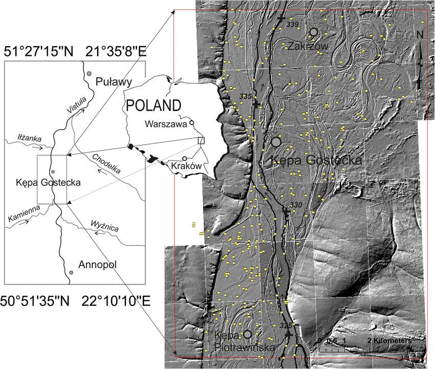
Morphodynamic conditions of heavy metal concentration 1037
these reports are related to the distribution of heavy metals migration visible in the landscape and crescent-shaped
in flood facies, depending on the distance from the source oxbow lakes. Lower dynamics of fluvial processes in this
of pollution [4,8], distribution of metals in flood facies interval are recorded through the presence of a loam
along the entire river course (from source to mouth) layer representing flood deposits with an average thick-
[10,33], relationship between metal concentration and ness of 3–4 m. In the neo-Holocene, changes of the
chemical properties of the deposits, in which they occur hydrological regime caused by management of the
[6,34], and heavy metal concentration depending on the catchment area (e.g. deforestation, intensification of
distance measured from the river channel [13,21,22,35]. In agriculture and introduction of root crops) resulted in
turn, studies on the relationship between heavy metal both an increase in the differences between extreme flows
concentration and the pattern of floodplain features, and the transformation of the meandering river into a
representing the so-called geomorphological–geochemical braided river. The overloaded river formed a new flood-
approach, are relatively few [1]. In our opinion, such an plain feature along the channel – a braided belt – and a
approach could better explain the distribution of anthro- wild river developed [42,45,46]. Acceleration of the
pogenically induced heavy metal concentration in change rate is linked with narrowing of the vegetation
alluvial deposits. Hence, this work focused on deter- zone and introduction of root crops, which caused an
mining the degree to which the variability of the increase in the supply of washout deposits and a
dynamics of contemporary fluvial processes influences decrease in the catchment retention. Increased dynamics
the concentrations of trace elements in alluvial deposits of the floodwater flow zones accompanying the transfor-
forming the bottom of the Vistula River valley in the mation of the Vistula River fluvial system caused a partial
vicinity of Kępa Gostecka. transformation of the floodplain surface formed during
the meandering process. Dynamic floodwater flows
removed fragments of loamy muds of the meandering
river and caused deposition of silty and sandy floodwater
2 Study area deposits [47].
The analysed stretch (325–339 km) of the Vistula River
valley is located between Kępa Piotrawińska and Zakrzów
(Figure 1) and comprises a part of the Małopolska Gorge 3 Methods
of the Vistula River [36,37]. The shape of the valley is
strictly linked to variable resistance of the eroded Upper Lithological variability of floodplain surface deposits in
Cretaceous rocks: siliceous marls, gaizes, marls and the study stretch of the Vistula River valley was
limestones [38–40]. In stretches where the valley is geologically mapped using both aerial photographs at
carved in rocks that are more resistant to erosion the the scale of 1:20,000, acquired in 2003, and a digital
valley is narrower and has distinctly steeper slopes [41]. elevation model (DEM) with a resolution of 10 and 1 m.
The analysed stretch is referred to as free mature [42] Two hundred and fifty-nine drillings (Figure 1) were
There, the dynamics of the erosional and depositional made to a depth of about 4 m or to the groundwater level
processes in the river freely reacted to the changes of the using an Eijkelkamp liner sampler set with a diameter of
hydrogeological regime in the latest Pleistocene and in 90 mm. Eight hundred and thirty-one samples of alluvial
the Holocene, developing the observed Pleistocene deposits were collected for laboratory analysis. The
overbank terraces and the bipartite floodplain (Figure 2). samples were collected from each subsequent lithological
Upper accumulation surfaces were formed by the layer starting from a depth of 0.6 m or from every 0.5 m.
braided and overloaded Vistula River, with a significant The collected samples were stored in zipper storage bags.
contribution of slope processes [43]. Grain size analysis by areometric and sieve methods
The development of the contemporary floodplain allowed determining the content of individual fractions,
commenced with the Late Vistulian climate warming, especially the clay fraction, and specifying the type of
which caused rapid evolution of forest communities [44] the deposits [48]. This was performed on 257 deposit
and change of the hydrological regime. Surface flow samples selected on the basis of macroscopic analysis.
decreased along with bedload supply to the Vistula River The organic matter content was determined in selected
channel. The meandering Vistula River incised into a samples based on loss on ignition at 440°C (following
surface composed of Pleistocene alluvia forming the the American Standard ASTM D 2974-87). The calcium
floodplain horizon, which is reflected in traces of channel carbonate fraction in the samples was tested using the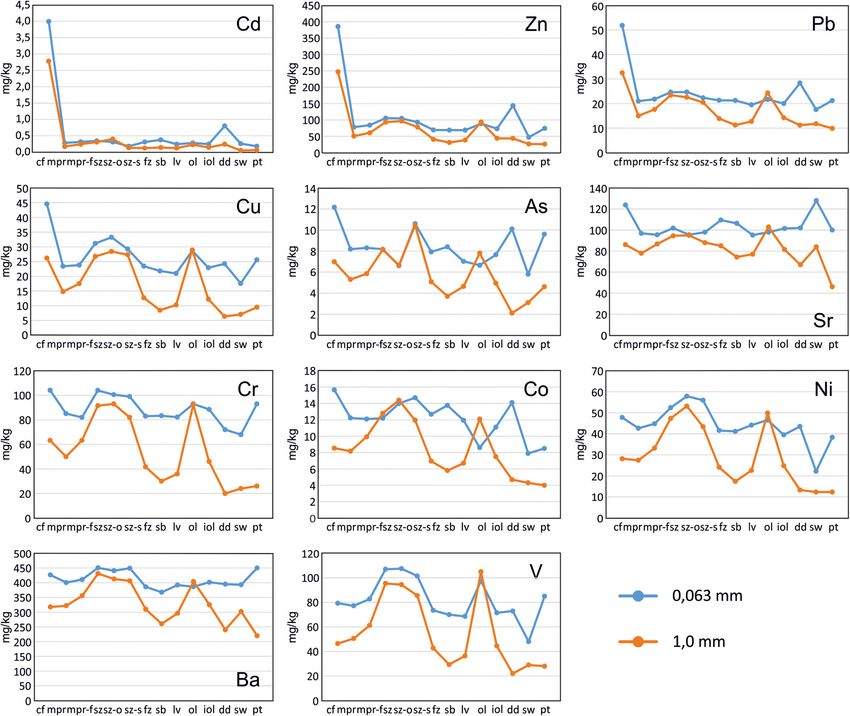
1038 Agnieszka Kałmykow-Piwińska and Ewa Falkowska
Figure 1: Location of the study area with sampling sites on a DEM image.
Scheibler method, and the iron content was analysed analysis (DCA) in PAST3 and one-way analysis of
using the iodometric method [48]. variance (ANOVA). The significance of this variability
Geochemical analyses were performed on 155 repre- was tested using the non-parametric Kruskal–Wallis
sentative deposit samples: 84 from a depth of 0.6 m and statistics (Statistica 12, StatSoft). For some analyses, the
the remaining from subsequent deeper layers. The data were grouped to increase sample abundance. Statistical
samples were dissolved in an H2O–HF–HClO4–HNO3 analyses were performed for the 1.0 mm fraction.
solution (at the ratio of 2:2:1:1) [49]. Determinations of 11
trace elements (Cu, Pb, Zn, Ni, Co, As, Sr, Cd, V, Cr and Ba)
from the 0.063 and 1.0 mm fractions were made at Acme
Labs (Bureau Veritas Commodities Canada Ltd) using 4 Results
inductively coupled plasma atomic emission spectroscopy
or inductively coupled plasma mass spectrometry.
4.1 Morphogenesis and lithology of the
Based on cartographic analysis and field data, zones
characterised by different morphodynamics have been floodplain
distinguished, with typical lithological profiles attributed
to each zone. Next, lithological cross-sections of the Based on aerial photographs and DEM analysis coupled
valley bottom were constructed. with geological field mapping, the following 18 geomorpho-
Principal component analysis (PCA) and regression logical zones/features were distinguished in the study
analysis of the contents of the clay fraction, organic stretch (Figure 2): contemporary floodplain (cf), meander
matter, calcium carbonate and iron oxides and hydro- plain reworked by flows of the contemporary braided river
xides were performed in Statistica 12 (StatSoft) to (mpr), meander plain reworked by flows of the contem-
determine the factors influencing the trace element porary braided river with flat and levelled surface (mpr-f),
distribution. The confirmation of the differences between stagnation zones of floodwaters (sz), oxbow lakes buried
heavy metal concentrations in deposits of individual under floodplain or organic deposits (sz-o), escarpment foot
features was made using detrended correspondence back swamps (sz-s), concentrated flow zones of floodwaters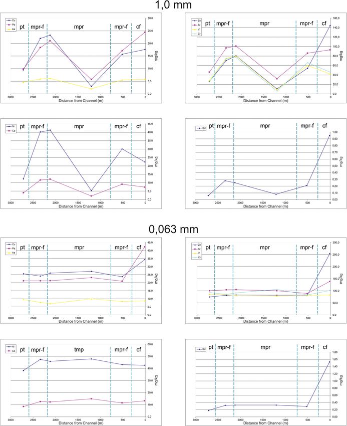
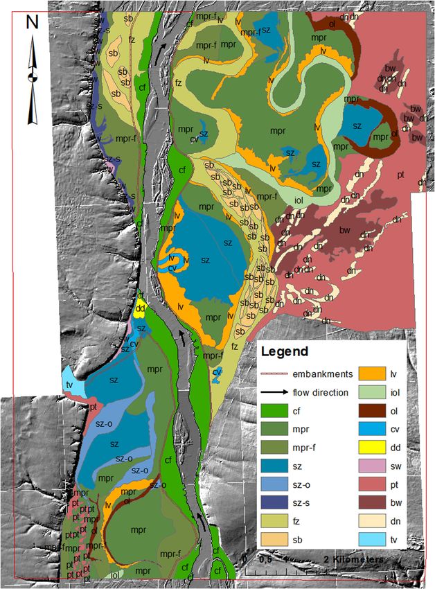
Morphodynamic conditions of heavy metal concentration 1039 Figure 2: Floodplain features on a DEM image. (fz), sandy bars (sb), levee deposition zones (lv), alluvial the Pleistocene terrace (bw) and tributary valleys (tv) deposits infilling oxbow lakes (iol), oxbow lakes (ol), (Krępianka valley). crevasses (cv), deltaic deposition zones (dd), slope wash The contemporary floodplain (cf) of the braided river zones (sw), Pleistocene terrace (pt), dunes (dn), blowouts on is limited by flood embankments and occurs in the form
1040 Agnieszka Kałmykow-Piwińska and Ewa Falkowska
Figure 3: Lithological profiles of the identified features.
of wide strips along the channel (Figure 2). Traces of the mpr-f is composed of clay loams, loams, clays and,
erosion caused by floodwater can be seen on its surface. occasionally, silts. Variably grained sand also occurs at the
Parts of this feature located deep within the floodplain base of the mpr and mpr-f profiles (Figure 3).
are composed of medium and fine sand, usually covered In the southern part of the study area, in the
by silty or clayey sand. At the boundary with the “mouth” (estuary) of the Krępianka River (left tributary
channel, this feature is composed of loams intercalated of the Vistula River), stagnation zones (sz) occur. These
with sand layers (Figure 3). consist of large surfaces of irregular outline, with
Analysis of DEM and aerial photographs shows deposition of organic deposits (Figure 2). Their formation
traces indicating that the meandering plain has been is related to blocking of water runoff by contemporary
transformed by flood flows of the modern braided river. depositional zones. Organic deposits are often covered
This happened before the embankments were built and with a layer of mineral sediments (sands and loams).
is currently taking place during embankment failure. Such stagnation zones (sz) also include landlocked
This feature covers the largest part of the valley and has depressions on the surface of the meander plain,
the greatest lithological variability. Due to differences in periodically flooded by waters of the contemporary
morphology, two features can be distinguished: meander Vistula River. They are also characterised by a specific,
plains reworked by flows of the contemporary braided bipartite structure; crevasse splays occur in this area.
river (mpr) with distinct traces of meander migration and These forms comprise a series of elongated radial bars
meander plains reworked by flows of the contemporary separated by depressions. At the “mouth” of the
braided river (mpr-f), on which these traces have been Krępianka, the crevasse splays are composed of sands
completely removed, and the surface is flat and levelled. or loamy-silty muds intercalated with sands, often with
The mpr-f usually occurs in the direct vicinity of the the sand at the base. Depressions between them are
contemporary or ancient river channel or near concen- usually filled with peats and muds, often covered by
trated flow zones of floodwaters (fz) (Figure 2). The mpr loamy-silty mud, with intercalations of sand at the base.
is characterised by diverse lithological profiles, though In the northern part of the area, organic deposits of sz
clay-silty muds with irregular intercalations of sands are characterised by much lower organic matter content
and, occasionally, clays mainly occur here. Comparatively, than in the southern part. Peats occur here as individualMorphodynamic conditions of heavy metal concentration 1041
intercalations. Profiles of the depressions comprise fz and oxbow lakes. Their profile comprises loamy-silty
clay-loamy muds with sand at the base, and those of muds interbedded with sandy deposits. Profiles com-
the splays include loams, silts and silty sands (Figure 3). posed of sands usually covered with silt were also
The deltaic deposition zone (dd) that blocks water observed (Figure 3).
runoff at the mouth of the Krępianka has been formed Oxbow lakes occur on the surface of the meander
and still develops during high water of both the Vistula plain, often with traces of reworking by contemporary
and Krępianka rivers. It is characterised by a smooth floodwater. Presently, they are filled with organic (ol)
surface incised by fan-like, shallow and narrow depres- and mineral deposits (iol). Oxbow lakes are variably
sions. It also comprises fine sands with a thickness developed in the northern and southern zones of the
exceeding 3 m, covered by a mud layer of the con- analysed stretch of the Vistula River. In the southern
temporary braided river, developed as silt (Figure 3). zone, ol are largely reworked into small and narrow
Buried oxbow lakes (sz-o) occur in the southern part forms. In turn, in the northern part of the area, they
of the study area, on the left bank of the Vistula River occur mainly in a zone adjacent to the margin of the
(Figure 2). They form distinct depressions on the surface of upper terrace as well-developed depressions reflecting
the reworked meander plain. They are only partly reworked the ancient shape of the channel, in which sedimenta-
(covered by younger deposits). The sz-o profile is composed tion of lake and bog deposits took place (Figure 2). Their
of peats and muds, overlain by clay-loamy muds with profile is composed of peats and muds with fine and
thicknesses ranging from 0.5 to 1.5 m (Figure 3). medium sands at the base. In turn, a series of iol forms,
Elongated depressions – escarpment foot back swamps also in the northern part of the floodplain in the
(sz-s) – occur at the boundary between the valley and the analysed stretch, are composed of silts, silty sands and
plateau in the northern part of the study area, on the left sands occasionally interbedded with loam (Figure 3).
bank of the Vistula River. Sets of these depressions are They attain characteristic shapes of ancient meanders
distributed parallel to the plateau margin (Figure 2). The with traces of floodwater flows.
zones of escarpment foot back swamps are places of the In places where floodwaters entered the meander
smallest aggradation of contemporary floodwater deposits, plain forming sz, small elongated depressions – cre-
resulting in accumulation of the finest material. As a result, vasses (cv) – were formed. Their profile comprises clay
these zones are characterised by lower elevations than the muds underlain with silt. Fine sands occur at the base of
surrounding features. This favours the development of the profile (Figure 3).
hydrogenic habitats. They are supplied both from flood- Slope wash zones (sw) represented by small fans
water and groundwater flowing from higher levels. Their were noted only in the northern part of the study stretch,
profile is composed of clay-silty muds, occasionally at the base of the plateau slope (Figure 2). They are
interbedded (or covered) with sands. The thickness of composed of fine sands with the debris of Cretaceous
muds is usually slightly below 1.0 m (Figure 3). limestones, 1.4–1.9 m in thickness. Below, there are
Concentrated flow zones of floodwaters (fz) can be loamy-silty muds of the meandering river, or muds and
recognised on the floodplain surface. They are developed clays of ancient back swamps formed at the foot of the
as elongated forms characterised by surface relief escarpment. Occasionally, residual lags occur at the base
parallel to their elongation. Their profiles show grain of this feature. The morphologically lower parts of sw are
size coarsening with depth. On the surface, the deposits covered by silty muds of the contemporary braided river
include loams and silty loams or silts, passing down- (Figure 3).
wards into fine sands interbedded with silt and fine and The Pleistocene terrace (Pt) is also observed in the
medium sands (Figure 3). analysed stretch (Figure 2). Its character and preserva-
Sandy bars (sb) were distinguished within the fz or tion in the northern and southern parts are different. In
in their direct vicinity in the central and northern parts the southern part, its fragments occur as isolated
of the analysed stretch of the Vistula River. They form elevations – outliers or narrow sandy strips adjacent to
lenticular structures parallel to the channels of concen- the escarpment. In the north, this upper terrace forms a
trated flow (Figure 2). The sb profile comprises fine and vast sandy horizon, over 2 km wide. The Pt profile
medium sands with a thickness exceeding 2 m, some- comprises fine, medium, coarse and silty sands and, in
times covered by loamy-silty muds or interbedded with some locations, silts. Locally, outliers of this terrace are
silty sands (Figure 3). characterised by the presence of loamy horizons with
The presence of levee deposition zones (lv) was variable thickness. Dunes (dn) and blowouts (bw) occur
noted in the direct vicinity of the Vistula River channel, on the surface of Pt (Figure 2). The features of dn are1042 Agnieszka Kałmykow-Piwińska and Ewa Falkowska
Figure 4: Clay fraction, organic matter, iron oxides and hydroxides and calcium carbonate contents in deposits of particular features of the
study area.
composed of fine and medium sand, whereas those of of clay fraction is observed in mpr deposits, while of organic
bw are represented by thin loamy muds (about 1 m) with matter in ol deposits. In all these deposits, the range of the
sands at the base (Figure 3). obtained results is very wide and varies from 0 to 48% for the
In the mouth zone of the Krępianka tributary valley (tv), clay fraction content and from 0 to 37% for the organic
about 400 m wide (Figure 2), organic deposits occur. At a matter content. The highest and most variable carbonate
depth of 0.8–1.0 m, below a layer of silts interbedded with content is found in cf deposits. Moreover, carbonates occur in
silty loams or sandy muds, 0.8 m thick peats are found. Fine fz, sb and sw deposits, as well as in single samples from mpr,
sands occur at the base of the peats (Figure 3). mpr-f and sz. The CaCO3 content does not exceed 5%. The
The individual features differ in the content of clay highest average contents of iron oxides and hydroxides are
fraction, organic matter, carbonates and iron oxides and found in sz deposits (1.92%; Figure 4).
hydroxides (Figure 4). The highest contents of the clay
fraction and organic matter occur in ol, sz, sz-o, sz-s and cv
deposits and slightly lower in mpr-f deposits. The average
values in the deposits of these features vary from 31 to 48% 4.2 Heavy metal content in the sediments
for the clay fraction content and from 4 to 26% for the of individual floodplain features
organic matter content (Figure 4). The lowest contents of clay
fraction and organic matter were noted in dd, sb, lv, fz, sw The trace element contents in deposits of individual flood-
and pt deposits. In turn, the highest variability of the content plain features in the study stretch of the Vistula River displayMorphodynamic conditions of heavy metal concentration 1043
Figure 5: Heavy metal concentrations in deposits of particular features in the analysed stretch of the Vistula River.
considerable variability (Figure 5). In the 1.0 mm fraction (the Cd were noted in cf and dd; Co and As in cf, sz-s and dd; Cu
particle-size class), Cd, Zn and Pb have the highest and most and Cr in cf, sz, sz-o, sz-s and ol; V in sz, sz-o, sz-s and ol;
variable concentrations in cf deposits. This is the most and Ni and Ba in sz, sz-o and sz-s. The lowest Sr contents
evident in the case of Cd (average concentration 2.67 ppm). were observed in cf deposits (Figure 6). For the 0.063 mm
The highest concentrations of the remaining elements (Cu, fraction, the lowest concentrations were observed in deposits
Ni, Co, As, Sr, V, Cr and Ba) occur in ol, cv, sz, sz-o and sz-s of sw (Cu, Pb, Zn, Ni, Co, As, V and Cr), ol (Co, As) and pt
deposits, and the lowest in sb, dd, sw, pt, lv and fz deposits. (Ni and Co) (Figure 6).
The greatest variability of all heavy metal contents is observed
in cf and mpr deposits (Figure 5).
The concentrations of trace elements are higher in the 4.3 Statistical analysis
0.063 mm fraction than in the particle-size class 1.0 mm, with
smaller differences between deposits composing individual According to PCA, the distribution of Cd, Zn and Pb is
features (Figure 6). The highest concentrations of Pb, Zn and influenced mostly by the carbonate content. In contrast,1044 Agnieszka Kałmykow-Piwińska and Ewa Falkowska
Figure 6: Comparison of the heavy metal concentrations in the 0.063 and 1.0 mm fractions of deposits studied.
the distribution of Cr, Sr, Cu and As depends on the Cr concentration depends more strongly on the clay
organic matter content, while the distribution of Ba, Co, fraction content than on the organic matter content,
V and Ni is dependent on the clay fraction content according to the formula:
(Figure 7). This is confirmed by regression analysis. An Cr = 1.188 × CLAY + 5.976 × OM + 12.444
exception is the Pb concentration that depends on the
organic matter content more strongly than on the where Cr is the Cr concentration in the deposit (mg/kg),
carbonate content, according to the formula: CLAY is the clay content (%) and OM is the organic
matter content (%); the standardised regression coeffi-
Pb = 3.282 × OM + 6.610 × CaCO3 + 6.719,
cient between Cr concentration in the deposit and clay
where Pb is the Pb concentration in the deposit (mg/kg), content is 0.531, and the standardised regression
OM is the organic matter content (%) and CaCO3 is the coefficient between Cr concentration in the deposit and
carbonate content (%); the standardised coefficient organic matter content is 0.386.
between Pb concentration in the deposit and organic DCA shows that the heavy metal concentrations in
matter content is 0.584, and the standardised coefficient the deposits vary among individual floodplain features
between Pb concentration in the deposit and carbonate (Figure 8). This is best seen in the case of contemporary
content is 0.508. floodplain (cf) deposits. Such forms as deltaic depositionMorphodynamic conditions of heavy metal concentration 1045
Table 1: Results of ANOVA analysis and Kruskal–Wallis statistics
Heavy metal ANOVA test Kruskal–Wallis test
F (3.77) p KW-H (3.81) p
Cu 18.3673 0.0000 41.7947 0.0000
Pb 15.6895 0.0000 42.1201 0.0000
Zn 14.7354 0.0000 44.1310 0.0000
Ni 22.2030 0.0000 39.2931 0.0000
Co 11.0608 0.0000 25.5777 0.0000
As 15.2596 0.0000 32.5123 0.0000
Sr 4.5257 0.0056 17.7873 0.0005
Cd 15.8970 0.0000 26.2270 0.0000
V 29.8521 0.0000 43.9452 0.0000
Cr 23.9058 0.0000 41.7917 0.0000
Ba 15.7257 0.0000 34.1266 0.0000
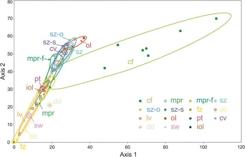
deposits of meander plain reworked by flows of
contemporary braided river (mpr) (Figure 8).
ANOVAs for deposits of the contemporary floodplain (cf),
Figure 7: PCA for heavy metals in the deposits studied. meander plain reworked by flows of the contemporary
braided river (mpr), stagnation zones of floodwaters (sz) and
zones (dd), Pleistocene terrace (pt), slope wash zones concentrated flow zones of floodwaters (fz) show differences
(sw) and oxbow lakes (ol) are less clearly distinguished. in the contents of the analysed heavy metals (Table 1).
The trace element contents in stagnation zones of
floodwaters (sz), oxbow lakes buried under floodplain
or organic deposits (sz-o), escarpment foot back swamps
(sz-s) and crevasses (cv), as well as concentrated flow 5 Discussion
zones of floodwaters (fz), sandy bars (sb) and levee
deposition zones (lv) show similarities. In turn, the most The processes of evolution of fluvial systems, influencing
variable heavy metal concentrations are found in the the floodplain morphology [50,51], depend on many
Figure 8: DCA for heavy metals in the deposits studied.1046 Agnieszka Kałmykow-Piwińska and Ewa Falkowska
factors, such as tectonic processes [52,53], climate floods. In contrast, other studies have noted the increase
change [41,54] and changes in the settings of the in heavy metal concentration with increasing distance
catchment area caused by, e.g., human industrial from the channel [13]. This was linked with the
activity (e.g. [42,51,55–58]). Such phenomena also increasing content of the finest fraction in the deposits,
influenced the relief of the analysed stretch of the resulting from the smaller flow dynamics of floodwater
Vistula River valley, as well as caused the development reaching the valley margin. The discrepancy of the
of a specific feature pattern and the lithology and obtained results may also result from analysing different
chemical composition of deposits of these forms. Our fractions −0.063 mm by Martin [21,35] and Ciszewski [22]
results show that the distribution of heavy metals in and 1.0 mm by Wyżga and Ciszewski [13]. In the present
these forms is strictly linked with the pattern and deposit study, we also show differences in the trace element
composition of these features. In general, heavy metal content in transverse cross-sections, different for the
concentrations measured by us in the alluvia of the individual fractions. However, in the study site, the
Vistula River in the analysed stretch are higher than observed variations of heavy metal content in deposits of
those presented in the Geoenvironmental Map of Poland the 1.0 mm fraction correspond to the feature pattern
[59,60] and the Geochemical Atlas of Poland [61,62], but and not to the distance from the channel. In turn, most
lower than the contents found in floodplain deposits of elements (Cd, Zn, Pb, Cu, As, Sr and to a smaller degree
polluted European rivers, e.g. the Rhine [8], Dill [4], Cr) of the 0.063 mm fraction show the highest concen-
Seine [23], Odiel [6] and Ohře [63]. trations in direct vicinity of the channel, i.e. in deposits
Differences in the concentrations of trace elements of cf that developed during the greatest supply of
have so far been determined in deposits of many river pollutants, particularly from the mining areas of Upper
valleys: Lahn [21,35], Bystrzyca [64,65], Warta near Silesia. Considerably smaller concentrations were noted
Poznań [66] and Middle Odra valley [22]. However, these in the remaining deposits composing forms located
studies consider only the distance from the sampling much further from the channel (Figure 9). Increased
sites to the river channel without the subdivision of the supply of heavy metals in the Vistula River valley is also
valley into features. Our investigations have shown that influenced by the mineral composition of these deposits,
the distribution of trace elements in the alluvia of the playing an essential role in binding trace elements.
Vistula River near Kępa Gostecka differs among indivi- Lithology, controlled by the sedimentary conditions,
dual features (Figure 5). The presented relationships particularly the contents of the clay fraction, organic
between the concentration of heavy metals in deposits matter, carbonates and free iron oxides and hydroxides
and the pattern of floodplain features are in accordance [18,68–70], influences the variable concentration of
with the regularities observed in other parts of the heavy metals in deposits of individual valley zones.
Vistula River valley – within a stretch formed in non- The PCA performed for the deposits of the Vistula River
rocky deposits [14] and in a stretch located upstream the valley near Kępa Gostecka, with the principal compo-
study area, i.e. near Solec nad Wisłą [49]. Spatial nents corresponding to the proxies mentioned above,
variability of heavy metal concentration was earlier has shown regularities in geochemical affinity of the
observed also in the Biała Przemsza and Sztoła river analysed elements. It also allowed explaining the
valleys [24], but those studies focused on deposits of the variable concentration of these elements in deposits of
channel and the adjacent contemporary floodplain. Such various floodplain zones. Because the variable concen-
analyses were also carried out in the Odra valley and the trations of Cd, Zn and Pb are influenced mostly by the
Upper Vistula valley near Oświęcim [67]. However, the carbonate content (Figure 7), and the deposits con-
tested stretches have been channelled there, which taining CaCO3 – compared with other features – are most
makes them difficult to compare with the Vistula in our common in cf, these elements reach the highest
research area. concentrations in cf deposits (Figure 5). In turn, organic
The distance from the channel is included in most matter is a factor determining the variability of contents
analyses of heavy metal content in alluvial deposits, but of Sr, As, Cr and Cu, while the clay fraction is most
the obtained relationships are not unequivocal and important in the case of V, Ba, Co and Ni (Figure 7). The
repeatable. Some researchers have observed the highest forms related to river water stagnation, which contain
concentrations in the direct neighbourhood of the large amounts of organic matter, are also characterised
channel [21,22,35], which was attributed to the fact that by high clay fraction content. Therefore, elements linked
the elements were supplied to the floodplain located at with organic matter and clay fraction reach the highest
some distance from the channel only during extensive concentrations (in the 1.0 mm fraction) in ol, sz, sz-o,Morphodynamic conditions of heavy metal concentration 1047 Figure 9: Heavy metal concentrations depending on the distance from the channel in the 0.063 and 1.0 mm fractions. See Figure 1 for the location of cross-sections. sz-s and cv deposits. The influence of iron oxides and study area is not significant, as indicated by both PCA hydroxides on the distribution of heavy metals in the and regression analyses. This may result from the fact
1048 Agnieszka Kałmykow-Piwińska and Ewa Falkowska
that the contents of iron compounds do not differ in the Deposits of cf can be clearly distinguished in the heavy
deposits of individual features (Figure 4). metal analysis (in the 1.0 mm fraction). The highest
In the analysed stretch of the Vistula River, the contents of Cd, Zn and Pb and high contents of Sr, Ni,
complex structure of the floodplain corresponds to the Cu and Cr (Figure 5) are due to the presence of clay
variable distribution of heavy metals in deposits of fraction, organic matter and calcium carbonate in these
individual features. Thus, there is a relationship between deposits. Their presence results from the occurrence of
the distribution of heavy metal concentration within the stagnation periods of floodwater in the zone between the
floodplain features and their origin. This relationship is embankments, during which deposition of fine sediments
marked more strongly in the analysis of the 1.0 mm from suspension, additionally enriched in calcium carbo-
fraction, although the concentrations observed in this nate, takes place. The occurrence of high concentrations of
fraction are generally lower than in the 0.063 mm Cd, Zn and Pb in cf deposits is commonly observed in river
fraction (Figure 6). This results from the fact that the valleys located in industrial areas [73,74]. High (exceeding
finer (0.063 mm) of the two particle fractions is background values) concentrations of these elements in
characterised by a higher content of clay fraction and deposits of the contemporary floodplain in the direct
organic matter [9,71]. Selection of the chemically most vicinity of the channel were earlier indicated, e.g. in the
active components of the deposits causes obliteration of Bystrzyca [64], Lahn [21,35] and Middle Odra valleys [22].
the impact of fluvial processes having an influence on The highest concentrations of most heavy metals in
the lithological variability of the deposits. Therefore, the 0.063 mm fraction were found in cf (Cd, Zn, Pb, Cu,
trace elements in the 0.063 mm fraction, collected from As, Sr, Co and Cr) and dd deposits (Cd, Zn, Pb, Cu, As
floodplain deposits, allow for the comparison of their and Co). This is because a greater amount of polluted
load supplied to the river at different moments. In turn, material was supplied to the area located closest to the
the results obtained for the 1.0 mm fraction better reflect contemporary channel. High concentrations of Cu, Ni, V,
sedimentary and morphogenetic processes within the Cr and Ba in the 0.063 mm fraction were also recorded in
river valley. deposits from features characterised by calm sedimenta-
The highest concentrations of heavy metals in the tion, flooded periodically during contemporary (prior to
1.0 mm fraction were recorded in deposits forming the embankment construction) floods (sz, sz-osz-s and in the
surface of periodically flooded zones, characterised by case of Cu, V and Cr – ol). In turn, the lowest concentra-
quiet sedimentation: sz, sz-o, sz-s, cv and ol (Figure 5). tions of most of the analysed trace elements in the
High contents of trace elements in these zones result 0.063 mm fraction were observed in the oldest features:
from the fact that these forms are filled with muds and, sw, ol and pt (Figure 6), developed before the period of
locally, by peats with high clay and organic matter the most intense anthropopression and pollutant supply.
contents (Figure 4). Stagnation of polluted waters of the More considerable differences in the heavy metal
Vistula River has also been observed in such zones, content in the 1.0 mm fraction than in the 0.063 mm
which, after the construction of flood embankments, fraction indicate that analyses performed for this fraction
reach here through embankment breakdown. The lowest may be used as proxies of morphogenetic processes in
concentrations of heavy metals in the 1.0 mm fraction floodplains of contemporary rivers.
were noted in deposits of zones linked with fast
floodwater flows, comprising coarser deposits with low
organic matter content. They include fz, sb, lv and dd, as
well as topographically upper and older features – sw 6 Conclusions
and pt (Figure 5).
In turn, the most variable trace element contents (in • The patterns of features and their lithologies in the
the 1.0 mm fraction) were observed in mpr deposits. This analysed stretch of the Vistula valley are strictly
variability results from the very diverse sedimentary related to the valley morphogenesis.
conditions of the different lithologies composing this • The variable concentration of trace elements in the
part of the floodplain [42,45,72]. Compared to mpr, surface deposits is linked with the specific morpho-
slightly higher concentrations of heavy metals were dynamics of this valley stretch.
noted in the analysed stretch of the Vistula River in mpr-f • This variability results from different sedimentary
deposits characterised by a higher content of the clay conditions of the floodplain deposits and the possibi-
fraction and organic matter (Figure 3). This feature is lity of mobilising the earlier deposited bedload by
usually located near the channel or near the fz. floodwater.Morphodynamic conditions of heavy metal concentration 1049
• In the studies of content of heavy metals, the Vistula River Valley between Annopol and Gołąb]. Prz Geol.
relationship between fluvial processes and their con- 2005;53:681–6 (in Polish with English summary).
centration is better reflected in the 1.0 mm fraction [13] Wyżga B, Ciszewski D. Hydraulic controls on the entrapment of
heavy metal-polluted sediments on a floodplain of variable
than in the 0.063 mm fraction.
width, the upper Vistula River, southern Poland.
Geomorphology. 2010;117:272–86.
[14] Falkowska E, Falkowski T. Trace metals distribution pattern in
Acknowledgments: This study was financed by research floodplain sediments of a lowland river in relations to
grant no. 012/05/B/ST10/00931 of the National Science contemporary valley bottom morphodynamics. Earth Surf Proc
Land. 2015;40:876–87.
Centre (Poland) to E. Falkowska. The authors thank the
[15] Horowitz AJ. A Primer on Sediment-Trace Element Chemistry.
reviewers and editor for their valuable comments that Michigan: Lewis; 1991. p. 1–134.
helped improve the manuscript. [16] Miller JR, Lechler PJ, Desilets M. The role of geomorphic
processes in the transport and fate of mercury within the
Carson River Basin, West-Central Nevada. Environ Geol.
1998;33:249–62.
[17] Walling D, Owens P, Carter J, Leeks G, Lewis S, Meharg AA,
References et al. Storage of sediment-associated nutrients and con-
taminants in river channel and floodplain systems. Appl
[1] Miller JR, Orbock Miller SM. Contaminated rivers: a geomor- Geochem. 2003;18:195–220.
phological–geochemical approach to site assessment and [18] Ciszewski D, Malik I, Wardas M. Uwarunkowania geomorfo-
remediation. Dordrecht: Springer; 2007. logiczne migracji metali ciężkich w osadach fluwialnych:
[2] Plak A, Zgłobicki W, Lata L, Telecka M. Formy biodostępne Cd, dolina Małej Panwi [Geomorphological influences on heavy
Cu, Pb, Zn w osadach den dolin zachodniej części Wyżyny metal migration in fluvial deposits: the Mała Panew River
Lubelskiej [Bio-available forms of Cd, Cu, Pb and Zn in the valley (Southern Poland)]. Prz Geol. 2004;52: 163–74
sediments of valley bottoms in the western part of the Lublin (in Polish with English summary).
Upland]. Landform Anal. 2014;24:65–71 (in Polish with English [19] Galán E, Fernandez-Caliani JC, Gonzales I, Aparicio P,
summary). Romero A. Influence of geological setting on geochemical
[3] Helios-Rybicka E. Impact of mining and metallurgical indus- baselines of trace elements in soils. Application to soils of
tries on the environment in Poland. Appl Geochem. South-West Spain. J Geochem Explor. 2008;98:89–106.
1996;11:3–9. [20] Conde Bueno P, Bellido E, Martín Rubí JA, Jiménez Ballesta R.
[4] Martin CW. Trace metal storage in recent floodplain sediments Concentration and spatial variability of mercury and other
along the Dill River, Central Germany. Geomorphology. heavy metals in surface soil samples of periurban waste mine
2015;235:52–62. tailing along a transect in the Almadén mining district (Spain).
[5] Leenaers H, Schouten CJ, Rang MC. Variability of the metal Environ Geol. 2009;56:815–24.
content of flood deposits. Environ Geol Water Sci. [21] Martin CW. Heavy metal concentration in floodplain surface
1998;11:95–106. soils, Laher River, Germany. Environ Geol. 1997;30:119–25.
[6] Santos Bermejo JC, Beltran R, Gomez Ariza JL. Spatial [22] Ciszewski D. Heavy metals in vertical profiles of the middle
variations of heavy metals contamination in sediments from Odra river overbank sediments: evidence for pollution
Odiel river (Southwest Spain). Environ Int. 2003;29:69–77. changes. Water Air Soil Pollut. 2003;143:81–98.
[7] Förstner U, Wittmann GTW. Metal pollution in the aquatic [23] Grosbois C, Meybeck M, Horowitz A, Ficht A. The spatial and
environment. Berlin, Heidelberg, New York: Springer- temporal trends of Cd, Cu, Hg, Pb and Zn in Seine River
Verlag; 1983. floodplain deposits (1994–2000). Sci Total Environ.
[8] Martin CW. Heavy metal storage in near channel sediments of 2006;356:22–37.
the Lahn River, Germany. Geomorphology. 2004;61:275–85. [24] Ciszewski D. Channel processes as a factor controlling
[9] Miller JR. The role of fluvial geomorphic processes in the accumulation of heavy metals in river bottom sediments:
dispersal of heavy metals from mine sites. J Geochem Explor. consequences for pollution monitoring (Upper Silesia,
1997;58:101–18. Poland). Environ Geol. 1998;36:45–54.
[10] Lecce SA, Pavlowsky RT. Floodplain storage of sediment [25] Ciszewski D. Flood-related changes in heavy metal concen-
contaminated by mercury and copper from historic gold trations within sediments of the Biała Przemsza River.
mining at Gold Hill, North Carolina, USA. Geomorphology. Geomorphology. 2001;40:205–18.
2014;206:122–32. [26] Förstner U, Müller G. Heavy metal accumulation in river
[11] Guéguen C, Dominik J. Partitioning of trace metals between sediments: a response to environmental pollution. Geoforum.
particulate, colloidal and truly dissolved fractions in a 1973;14:53–61.
polluted river: the Upper Vistula River (Poland). Appl [27] Förstner U, Müller G. Concentrations of heavy metals and
Geochem. 2003;18:457–70. polycyclic aromatic hydrocarbons in river sediments: geo-
[12] Falkowska E. Związek akumulacji metali ciężkich w osadach chemical background, man’s influence and environmental
facji powodziowych z morfologią doliny Wisły na odcinku od impact. GeoJournal. 1981;5:417–32.
Annopola do Gołębia [Relationship between the heavy metal [28] Brügmann L. Metals in sediments and suspended matter of
accumulation in flood deposits and the morphology of the the River Elbe. Sci Total Environ. 1995;159:53–65.1050 Agnieszka Kałmykow-Piwińska and Ewa Falkowska
[29] Boszke L, Sobczyński T, Głosińska G, Kowalski A, Siepak J. [45] Falkowski E. Ewolucja holoceńskiej Wisły na odcinku
Distribution of mercury and other heavy metals in bottom Zawichost – Solec I inżyniersko-geologiczna prognoza jej
sediments of the middle Odra River (Germany/Poland). Pol J dalszego rozwoju [Evolution of the Holocene Vistula from
Environ Stud. 2004;13:495–502. Zawichost to Solec with an engineering-geological prediction
[30] Pillay S, Naidoo K, Bissessur A, Agjee N, Pillay K, Purves B, of further development]. Biuletyn Instytutu Geologicznego.
et al. Sand mining impacts on heavy metal concentrations in 1967;198:57–131 (in Polish).
two important river systems of northern Kwazulu-Natal, South [46] Starkel L. The reflection of hydrologic changes in fluvial
Africa. J Hum Ecol. 2014;47:155–62. environment of the temperate zone during the last 15,000
[31] Valskys V, Valskienė R, Ignatavičius G. Analysis and assess- years. In: Gregory KJ, editor. Background to Paleohydrology:
ment of heavy metals concentrations in Nemunas river bottom a perspective. Chichester, New York: Wiley; 1983. p. 213–34.
sediments at Alytus city territory. J Environ Eng Landsc. [47] Falkowski T. Naturalne czynniki stabilizujące wybrane odcinki
2015;23:147–54. strefy korytowej Wisły Środkowej [Factors of natural stability
[32] Ciszewski D, Grygar TM. A review of flood-related storage and of the Middle Vistula River channel zones]. Warszawa:
remobilization of heavy metal pollutants in river system. Wydawnictwo SGGW; 2006 (in Polish with English summary).
Water Air Soil Pollut. 2016;227:239. [48] Myślińska E. Laboratoryjne badania gruntów i gleb
[33] Bojakowska I, Sokołowska G, Gliwicz T. Heavy metals in recent [Laboratory Soil Investigations]. Warszawa: Wydawnictwa
alluvium of the Odra River. Geol Q. 1997;41:395–404. Uniwersytetu Warszawskiego; 2010 (in Polish).
[34] Macklin MG, Dowsett R. The chemical and physical speciation [49] Falkowska E, Falkowski T, Tatur A, Kałmykow-Piwińska A.
of trace metals in fine-grained overbank flood sediments Floodplain morphodynamics and dis-tribution of trace ele-
in the Tyne Basin, North-East England. Catena. ments in overbank deposits, Vistula River Valley Gorge near
1989;16:135–51. Solec nad Wisłą, Poland. Acta Geol Pol. 2016;66:541–59.
[35] Martin CW. Heavy metal trends in floodplain sediments [50] Miall AD. The geology of fluvial deposits. Sedimentary facies, basin
and valley fill, River Lahn, Germany. Catena. analysis and petroleum geology. Berlin: Springer Verlag; 1996.
2000;39:53–68. [51] Vanderberghe J. The relation between climate and river
[36] Pożaryski W. Osady rzeczne w przełomie Wisły przez wyżyny processes, landforms and deposits during the quaternary.
południowe [River sediments in the Vistula Gap across the Quatern Int. 2002;91:17–23.
southern uplands]. Warszawa: Państwowy Instytut [52] Ouchi S. Response of alluvial rivers to slow active tectonic
Geologiczny; 1955 (in Polish). movement. Geol Soc Am Bull. 1985;96:504–15.
[37] Kondracki J. Geografia regionalna Polski [Regional geography [53] Silva CL, Morales N, Crósta AP, Costa SS, Jiménez-Rueda JR.
of Poland]. Warszawa: PWN; 2001 (in Polish). Analysis of tectonic-controlled fluvial morphology and sedi-
[38] Pożaryski W. Jura i kreda między Radomiem, Zawichostem i mentary processes of the western Amazon Basin: an approach
Kraśnikiem [Jurassic and Cretaceous between Radom using satellite images and digital elevation model. An Acad
Zawichost and Kraśnik (Central Poland)]. Biuletyn Bras Ciênc. 2007;79:693–711.
Państwowego Instytutu Geologicznego. 1948;46:5–141 [54] Kalicki T. Zapis zmian klimatu oraz działalności człowieka i ich
(in Polish). rola w holoceńskiej ewolucji dolin środkowoeuropejskich
[39] Żarski M. Szczegółowa mapa geologiczna Polski w skali [Reflection of climatic changes and human activity and their
1:50,000, arkusz Puławy [Detailed Geological Map of Poland role in the Holocene evolution of Central European valleys].
(1:50,000), Puławy sheet]. Warsaw, Poland: Polish Geological Pr Geogr. 2006;204 (in Polish).
Institute; 1998 (in Polish). [55] Kozarski S, Rotnicki K. Valley floors and changes of river
[40] Żarski M. Objaśnienia do szczegółowej mapy geologicznej channel patterns in the North Polish Plain during the Late
Polski w skali 1:50 000, arkusz Puławy [Explanations for the Wurm and Holocene. Qua Geo. 1977;4:51–93.
Detailed Geological Map of Poland (1:50,000), Puławy sheet.]. [56] Mycielska-Dowgiałło E. Channel pattern during the last
Warsaw: Polish Geological Institute; 1998 (in Polish). glaciation and Holocene in the northern part of the
[41] Starkel L. Historia doliny Wisły od ostatniego zlodowacenia do Sandomierz Basin and the middle part of the Vistula valley,
dziś [Evolution of the Vistula River valley since the last Poland. In: Gregory KJ, editor. River chanel changes.
glaciation till present]. Warszawa: Polish Academy of Chichester–New York–Brisbane–Toronto: Wiley; 1977.
Sciences, Institute of Geography and Spatial Organization; [57] Starkel L. Role of climatic and anthropogenic factors accel-
2001 (in Polish with English summary). erating soil erosion and fluvial activity in Central Europe.
[42] Falkowski E. History and prognosis for the development of bed Studia Quaternaria. 2005;22:27–33.
configurations of selected sections of Polish Lowland rivers. [58] Wyżga B. Impact of the channelization-induced incision of the
Biuletyn Geologiczny. 1971;12:5–121 (in Polish with English Skawa and Wisłoka Rivers, southern Poland, on the conditions
summary). of overbank deposition, Regul Rivers Res Mgmt. 17;2001:85–100.
[43] Pożaryski W, Maruszczak H, Lindner L. Młodoczwartorzędowe [59] Wierzbanowski P, Pasieczna A, Stec B, Tomassi-Morawiec H.
tarasy akumulacyjne i osady deluwialne w dolinie środkowej Geoenvironmental map of Poland (1:50,000), Opole Lubelskie
Wisły [Late Quaternary river terraces and deluvial deposits in sheet. Warsaw, Poland: Polish Geological Institute – National
the Middle Vistula valley (Central Poland)]. Prz Geol. Research Institute; 2006.
1999;47:808–12. [60] Bąk B, Szeląg A, Bojakowska I, Kwecko P, Tomassi-
[44] Ralska-Jasiewiczowa M. Impact of prehistoric man on natural Morawiec H, Wojciechowska K. Mapa Geośrodowiskowa Polski
vegetation recorded in pollen diagrams from different regions w skali 1:50,000. Arkusz Kazimierz Dolny. [Geoenvironmental
of Poland. Folia Quaternaria. 1977;49:75–91. map of Poland (1:50,000). Kazimierz Dolny sheet.]. Warsaw,Morphodynamic conditions of heavy metal concentration 1051
Poland: Polish Geological Institute – National Research [68] Ważny H, Stenzel P. Badania geochemiczne osadów
Institute; 2010. węglanowych cechsztynu z otworu wiertniczego Grzybnica
[61] Lis J, Pasieczna A, Strzelecki R, Wołkowicz S, Lewandowski P. IG 1 z zastosowaniem analizy czynnikowej – sposób R
Geochemical and radioactivity mapping in Poland. J Geochem [An interpretation of geochemical data concerning carbonate
Explor. 1997;60:39–53. Zechstein deposits from borehole Grzybnica IG 1 by means of
[62] Pasieczna A, editor. Atlas geochemiczny Polski 1:2 500 000 factor analysis – R mode]. Geol Q. 1976;20:538–50 (in Polish
[Geochemical atlas of Poland (1:2 500 000)], Warszawa: with English summary).
Wydawnictwa PIG-PIB [Polish Geological Institute – National [69] De Saedeleer V, Cappuyns V, De Cooman W, Rudy S. Influence
Research Institute]; 2012. of major elements on heavy metal composition of river
[63] Grygar TM, Elznicová J, Kiss T, Smith HG. Using sedimentary sediments. Geol Belg. 2013;13:257–67.
archives to reconstruct pollution history and sediment [70] Saulais M, Bedell J-P, Delolme C. Cd, Cu and Zn mobility in
provenance: the Ohře River, Czech Republic. Catena. contaminated sediments from an infiltration basin
2016;104:109–29. colonized by wild plants: the case of Phalaris arundinacea
[64] Bojakowska I, Sokołowska G. Heavy metals in the Bystrzyca and Typha latifolia. Water Sci Technol. 2011;64:255–62.
river flood plain. Geol Q. 1996;40:467–80. [71] Salomons W, Förstner U. Metals in the hydrocycle. Berlin:
[65] Zgłobicki W, Telecka M, Skupiński S. Assessment of Springer-Verlag; 1984.
Microscale Variation of Heavy Metal Pollution of the Bystrzyca [72] Zwoliński Z. Sedimentology and geomorphology of overbank
River Alluvia Downstream from Lublin. Po J Soil Sci. 2017;49:167. flows on meandering river floodplains. Geomorphology.
[66] Boszke L, Kowalski A. Mercury fractionation in sediments of 1992;4:367–79.
the Lower Vistula River (Poland). Oceanological and [73] Merian E, Anke M, Ihnat M, Stoeppler M, editors. Elements
Hydrobiological. Studies. 2007;36:79–99. and Their Compounds in the Environment. Weinheim:
[67] Ciszewski D, Czajka A. Human-induced sedimentation Wiley; 2004.
patterns of a channelized lowland river. Earth Surf Process [74] Kabata-Pendias A, Mukherjee AB. Trace Elements from Soil to
Landf. 2015;40:783–95. Human. Berlin: Springer, Verlag; 2007.You can also read