Subaqueous mass movements in the context of observations of contemporary slope failure - Geological Society, London, Special Publications
←
→
Page content transcription
If your browser does not render page correctly, please read the page content below

Downloaded from http://sp.lyellcollection.org/ by guest on November 11, 2021

Subaqueous mass movements in the context of
observations of contemporary slope failure
Joshu J. Mountjoy1*, Aggeliki Georgiopoulou2, Jason Chaytor3,
Michael A. Clare4, Davide Gamboa5 and Jasper Moernaut6
1
  National Institute of Water and Atmospheric Research, Wellington, New Zealand
2
  School of Environment and Technology, University of Brighton, UK
3
  United States Geological Survey, Woods Hole, USA
4
  National Oceanography Centre, Southampton, UK
5
  Instituto Português do Mar e da Atmosfera, Lisbon, Portugal
6
  Institute of Geology, University of Innsbruck, Austria
    JJM, 0000-0002-3703-0006; AG, 0000-0003-4298-5090; DG, 0000-0003-3323-4172
*Correspondence: joshu.mountjoy@niwa.co.nz

Abstract: The consequences of subaqueous landslides have been at the forefront of societal conscience more
than ever in the last few years, with devastating and fatal events in the Indonesian Archipelago making global
news. The new research presented in this volume demonstrates the breadth of ongoing investigation into sub-
aqueous landslides, and shows that while events like the recent ones can be devastating, they are smaller in scale
than those Earth has experienced in the past. Understanding the spectrum of subaqueous landslide processes,
and therefore the potential societal impact, requires research across all spatial and temporal scales. This volume
delivers a compilation of state-of-the-art papers covering regional landslide databases, advanced techniques for
in situ measurements, numerical modelling of processes and hazards.

This Geological Society Special Publication volume              past decade may not be as large or as devastating,
comes at a key time in the discipline of subaqueous             but they occurred in a time of rapidly advancing
mass movement research. Catastrophic recent events              technology in the field of Earth observation.
(e.g. at Anak Krakatau and during the Sulawesi                     In this introductory paper, we review recent sub-
Earthquake in 2018) have demonstrated the substan-              aqueous mass failure events, some of which have
tial hazard that can be associated with subaqueous              received widespread media coverage. We look at
landslides, with multiple fatalities directly attributed        these events in terms of how they can help us better
to landslide tsunami. Public awareness is greater than          study subaqueous mass movements, particularly
ever given the easy proliferation of information                from a hazard and risk perspective. We follow this
through new media formats (e.g. social media, live              review with a summary of the papers in this Special
streaming, blogging). While a significant amount                 Publication volume and emphasize why, in light of
can be learned from these contemporary events, in               contemporary events, they offer important and
the geological past there is a much larger range of             timely contributions to the discipline.
mass movement scales and variability in processes
that is preserved in seafloor and lakefloor geomor-
phology and in the sedimentary record. Untangling               Volcanic flank collapse at Anak Krakatau
the controls on past slope failures remains arguably
the main challenge in subaqueous mass movement                  On 22 December 2018 a volcanic flank collapse of
research, but one that can benefit greatly from con-             the Anak Krakatau volcanic island in the Sunda
sidering the context of direct observations of con-             Straits, Indonesia, created a tsunami that generated
temporary subaqueous slope failure.                             waves up to 1.4 m high at the coast, killing over
    There have been many instances over the past                400 people (Williams et al. 2019). This event is
50 years where subaqueous or partially subaqueous               defined by unprecedented remote sensing observa-
slope failure have been directly observed and the               tions when compared with previous historical volca-
hazard has been significant (Dan et al. 2007; Parsons            nic sector collapses, most notably the 1888 Ritter
et al. 2014). The events that have happened in the              Island event (Day et al. 2015). Anak Krakatau first

From: Georgiopoulou, A., Amy, L. A., Benetti, S., Chaytor, J. D., Clare, M. A., Gamboa, D., Haughton, P. D. W.,
Moernaut, J. and Mountjoy, J. J. (eds) 2020. Subaqueous Mass Movements and their Consequences: Advances in Process
Understanding, Monitoring and Hazard Assessments. Geological Society, London, Special Publications, 500, 1–12.
First published online May 26, 2020, https://doi.org/10.1144/SP500-2019-237
© 2020 The Author(s). This is an Open Access article distributed under the terms of the Creative Commons Attribution
License (http://creativecommons.org/licenses/by/4.0/). Published by The Geological Society of London.
Publishing disclaimer: www.geolsoc.org.uk/pub_ethics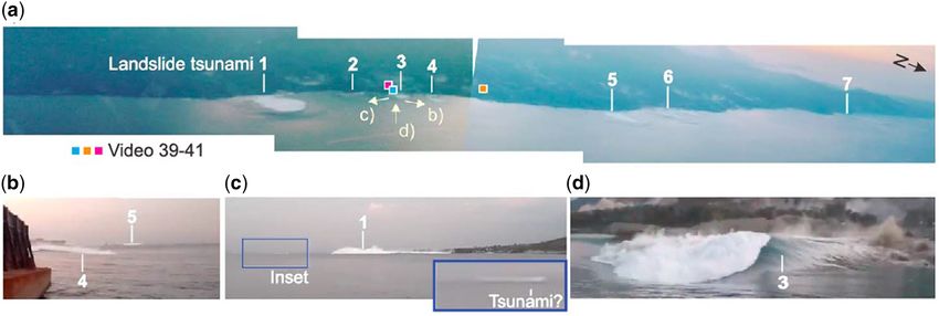
Downloaded from http://sp.lyellcollection.org/ by guest on November 11, 2021

2                                             J. J. Mountjoy et al.

grew above sea-level in 1929 and had risen to 300 m       tsunami with run-up of 6–11 m (Takagi et al.
elevation by December 2018, with changes docu-            2019). The combined events resulted in .4000
mented by repeat satellite observations. Sentinel sat-    deaths, but the number associated with the tsunami
ellite footage from just 8 h after the tsunami shows      alone remains unclear. Slope failures have been
the western flank failure and the collapse of the sum-     inferred to have a role in tsunami generation, sup-
mit (Williams et al. 2019). Using these observations,     ported by video observations of localized wave gen-
combined with geomorphic interpretation, a sub-           eration and evidence of coastal failures (Arikawa
aqueous component of the failure is calculated to         et al. 2018; Carvajal et al. 2019). While it is clear
be a modest 0.1 km3 and the subaerial component           from the extraordinary video footage collected at
0.004 km3. Previous work had identified the tsunami        the time that delta collapse and coastal landslides
hazard associated with flank collapse on Anak Krak-        caused tsunamis (Fig. 1), the role that subaqueous
atau, modelling a 0.28 km3 failure in approximately       slope failures played in the main wave generation
the same location, which generated the same tsunami       remains speculative, and no more conclusive than
height in some locations but with significantly            for comparative previous events where earthquake
slower arrival times (Giachetti et al. 2012). For post-   mechanisms could not clearly be reconciled with
event modelling of the tsunami, Grilli et al. (2019)      tsunami generation (e.g. Tappin et al. 2001). In
used a similar volume (0.27 km3 failure). In both         essence, we are still in a situation where there is
of these studies, a large component of the subaerial      no direct evidence for large, wholly subaqueous
cone is assumed to have failed concurrently with          landslide-generated tsunami. To make this link in
the subaqueous flank; however, Williams et al.             the future, with no doubt as to the mechanism, will
(2019) demonstrate that the cone did not fail and         most probably require an event to occur in a location
the subaerial component of the flank collapse was          where high-resolution bathymetry has previously
minor. New unpublished bathymetric data show              been collected. This becomes ever more likely as
that blocks up to 90 m high lie on the seafloor and        regional bathymetric datasets covering active conti-
the total slide mass volume is calculated to be           nental margins are being collected and analysed. In
0.19 km3 (http://www.bbc.com/news/science-envi            this volume, Watson et al. (2020) analyse regional
ronment-50798253). This event most probably will,         bathymetric coverage across the entire offshore
and should, become the touchstone for tsunami             component of the Hikurangi Subduction margin,
model validation and volcanic island flank collapse        New Zealand; Hill et al. (2020) present a study of
hazard assessment. It was a catastrophic event in         full-coverage multibeam data along almost 300 km
terms of loss of life, injury and displacement, despite   of the Cascadia Subduction Zone; Stacey et al.
the tsunami waves being comparatively small. The          (2020) and Lintern et al. (2020) present analyses
fact that this hazard had been well modelled in           of full-coverage bathymetric datasets in two active
advance provides affirmation of the value of under-        margin fjord systems; and León et al. (2020) present
taking research into subaqueous mass movement             a landslide database for offshore Spain. These com-
hazards. A key outstanding question in our under-         prehensive studies, amongst others, will set a valu-
standing of the Anak Krakatau landslide tsunami is        able baseline for analysing the impact of large
the discrepancy in the calculated volumes of the fail-    earthquakes in the future.
ure, which is something to which studies of the fail-         Although no tsunami has been directly linked to
ure history on volcanic cones can make a significant       subaqueous landslides, the November 2016 Kai-
contribution. Understanding the mechanism behind          koura Earthquake, New Zealand, is one of the best
contemporary events such as this one provides cru-        documented earthquake-triggered, wholly subaqu-
cial context for landslide tsunami hazard studies         eous seafloor-failure events to date (Mountjoy
when specific single-event failure mechanisms can          et al. 2018). The difference between 2 m-resolution
be demonstrated. Conversely, the study of historical      pre- and post-earthquake bathymetry shows wide-
cone collapse can reveal long-term behaviour, as          spread shallow-seated slope failures around the rim
Barrett et al. (2020) show for past flank collapses        of Kaikoura Canyon in close proximity to the docu-
in the Cape Verde Islands, where the deposition of        mented seafloor rupture of the Hundalee Fault
volcanic debris on the slope may have triggered a         (Mountjoy et al. 2018). Landslide failure depth is
chain of slope failures.                                  shallow (2–10 m) so it is unsurprising that no clear
                                                          landslide tsunami signal was detected. The signifi-
                                                          cant information that this event provides is that the
Earthquake triggering of subaqueous                       extent of landslide occurrence around the fault rup-
landslides                                                ture could be mapped, partly using multibeam differ-
                                                          encing and partly from the geomorphic signature of
Shortly preceding the Anak Krakatau tsunami, in the       fresh slope failures. Identifying the distribution of
same region, the 2018 Mw 7.5 Sulawesi earthquake          slope failures enabled the ground motion threshold
on the 28 September 2018 was accompanied by a             for landslide triggering in this area to be defined,
Downloaded from http://sp.lyellcollection.org/ by guest on November 11, 2021
Advances in subaqueous mass movements 3
Fig. 1. Some of the only images ever captured of natural landslide tsunami generation, taken at the time of the
Sulawesi earthquake in 2018 (Carvajal et al. 2019). Frames taken from (a) video footage and (b–d) near shoreline
photos of the resulting waves. The numbers 1–7 refer to seven separate locations of wave generation.
by a peak ground acceleration of 0.32g, and a return Active landslides in dynamic sedimentary
period to be calculated (Mountjoy et al. 2018). The environments
definition of a slope failure threshold has significant
implications for hazard assessments where estimat- Repeated failure (or contemporary ‘active’ landslide
ing the likelihood and distribution of subaqueous regions) in highly dynamic environments can sig-
slope failure can be approached based on the proxim- nificantly affect seafloor cables and oil field develop-
ity to fault rupture. An outstanding question, and one ments. This has been shown to be the case in
that observations following the 2016 Kaikoura submarine canyons (Clare et al. 2017; Pope et al.
Earthquake do little to address, is ‘what causes 2017) and on large deltas (Coleman et al. 1980). Sig-
very large subaqueous landslides?’. Despite the nificant efforts are being made to monitor and mea-
widespread occurrence of deep-seated landslides sure slope failure processes in these dynamic
onland (Massey et al. 2018), multiple offshore environments that include landslides, sediment bed-
fault ruptures (Litchfield et al. 2018), repeat mapping form change and turbidity current processes. Clare
of over 4000 km2 of seafloor – in an area with evi- et al. (2020) provide an overview of lessons learned
dence for multiple deep-seated landslides – no land- from recent field campaigns, including those at
slides greater than 0.1 km3 were documented for submarine deltas (e.g. the Squamish Delta, British
composite failure of the canyon floor, rather than Columbia, and the Var Delta, Mediterranean).
for canyon wall areas where past landslide evidence Repeat seafloor surveys and sediment flow monitor-
is preserved. This follows from several repeat obser- ing at the Squamish submarine delta have revealed
vations of the seafloor in the area of large earth- that short periods of rapid sediment accumulation
quakes where no large landslides have been can precondition the delta to fail and that landslides
detected (Tappin et al. 2007; Völker et al. 2011). of up to 150 000 m3 are ultimately triggered by tid-
Comparisons of passive v. active margin open slopes ally controlled pore pressure fluctuations (Hughes
show strengthening of the slope material on active Clarke et al. 2012; Clare et al. 2016; Hizzett et al.
margins due to earthquake shaking, demonstrating 2018). Chaytor et al. (2020) document pipeline
counter-intuitively that when earthquakes do not breaks on the Mississippi Delta, and use repeat sea-
cause slope instability, they in fact have the opposite, floor mapping to track object displacement (ship-
strengthening effect (Sawyer and DeVore 2015; wrecks, blocks). Their study shows that repeated
DeVore and Sawyer 2016; ten Brink et al. 2016; seafloor failure results in downslope movement
Sawyer et al. 2017; Molenaar et al. 2019). Whether rates of 85 m a−1 for blocks measured in the 2016–
this is the case for highly incised, canyon-dissected 17 period and potentially 150 m a−1 for the wreck
margins remains to be explored. This really high- of the SS Virginia. These repeat observations of sea-
lights the value of advancing analytical, laboratory floor change demonstrate that the Mississippi Delta
and case study research on the preconditioning and is subject to highly dynamic conditions, and that
triggering of deep-seated landslides to advance our slope failure can take place without major cyclonic
understanding of what makes large parts of the sea- events. It is now being recognized that repeated fail-
floor fail. Studying initiation, triggering and precon- ures of larger deep-seated landslides can occur in the
ditioning of subaqueous mass movements forms a same location, but such events differ as they involve
main focus in this volume. reactivation of the same material. SeafloorDownloaded from http://sp.lyellcollection.org/ by guest on November 11, 2021
4 J. J. Mountjoy et al.
instrumentation has enabled measurements of down- lacustrine landslides, which are commonly little con-
slope movement on the submerged flank of Mt Etna sidered but potentially catastrophic, even when
(Urlaub et al. 2018), and repeated movement is occurring on entirely submerged slopes (Daxer
hypothesized for the Tuaheni Landslides offshore et al. 2020; Moernaut et al. 2020; Strasser et al.
New Zealand (Mountjoy et al. 2009). Couvin et al. 2020; Strupler et al. 2020).
(2020) use new IODP drilling data in combination
with P-Cable 3D seismic to propose a new model
for the failure history of the Tuaheni Landslides. State of the art
The new data show that only the top 40 m of the
landslide is likely to be repeatedly reactivated, and While the recent events reviewed here highlight the
that this portion is dominated by decimetre-scale consequences of subaqueous mass movements,
sand units. they capture just a small part of the broader spectrum
of scales, processes and event hazards. The revealing
information about event timing and consequences
Glacial alpine environments: locus of (e.g. tsunami or infrastructure damage) is of great
value to practitioners, but leaves many gaps that
climate sensitivity need to be filled in by the study of past events,
The largest potential tsunami hazard related to sub- through numerical modelling and experimental
aqueous mass movements comes from large rock- research in the laboratory. The power of this volume
falls entering small water bodies (e.g. fjords and lies in the breadth of studies from across the world’s
lakes) where an extraordinarily large amount of ocean basins, fjords and lake environments (Fig. 2),
water can be displaced. This is exemplified by the going back through the depositional record to build
1958 Lituya Bay, Alaska, tsunami where a 1 km3 up a picture of the controls and triggers of subaqu-
rockfall generated a wave over 500 m high (Miller eous mass movements, their flow behaviour and
1960; Weiss et al. 2009). These extreme events are their impact on society. To develop a logical and eas-
rare and have mostly happened in remote areas; how- ily readable structure to the volume, the papers are
ever, it is definitely a significant concern that some- presented in four thematic areas.
thing like this might affect populated areas (Harbitz
et al. 2014) and improved understanding of the pre- Section A: consequences and implications
conditioning factors, frequency and dynamics of
these events is therefore very important. In 2015 in Understanding and quantifying tsunami hazards
Taan Fjord, Alaska, a 0.147 km3 rockfall generated related to subaqueous landslides remains a signifi-
a large tsunami, fortunately with no casualties cant challenge. Apart from fjord-wall instabilities,
(Haeussler et al. 2018). The tsunami run-up from the most significant landslide-generated tsunamis
this event was an astounding 193 m, making it are often attributed to the collapse of volcanic island
among the largest ever recorded (Higman et al. flanks, typically involving both subaerial and sub-
2018). Post-event mapping has enabled a detailed aqueous slope failure. In this issue, a case study at
calculation of the scale of the deposit, and the char- the base of Fogo Volcano (Cape Verde Islands; Bar-
acteristics of the source area (Dufresne et al. 2018; rett et al. 2020) highlights the need for high-
Haeussler et al. 2018). It is likely that landslides in resolution mapping of complex landslide deposits
glaciated areas will become more frequent as the cli- to accurately constrain the number of failures, the
mate changes and glaciers retreat (Grämiger et al. geometry of their deposits and the extent of possible
2017). Furthermore, increasingly dynamic landscape loading-induced deformation of pre-existing seafloor
processes in response to climate change will more sediments. This combined information is crucial for
rapidly obscure the onshore evidence for such events evaluating the tsunamigenic potential associated
(Dufresne et al. 2018), further highlighting the value with volcanic islands. In addition to landslide geom-
of the subaqueous record. etry, the characterization of landslide material forms
Given these points, the depositional characteris- a basic input parameter for landslide modelling,
tics of large landslides in alpine environments, as determining how sediment rheology affects land-
well as their extent, age and frequency, become slide processes. Such sedimentological analysis is
increasingly important. Several papers in this vol- presented for the Byron landslide, located on the
ume directly address this topic. Stacey et al. east Australian continental margin, and serves to
(2020) derive a magnitude frequency relationship inform hydrodynamic models constraining the asso-
for slope stability in the 140 km-long Douglas Chan- ciated tsunami hazard (Mollison et al. 2020). Tsu-
nel Fjord system in Canada, and show that poten- nami models are often based on very simplified
tially damaging landslides occur throughout the concepts considering the landslide source, such as
fjord. Several studies make basin-wide assessments the sliding block model. A more sophisticated
for lakes, illustrating the widespread occurrence of approach is presented in this volume, in whichDownloaded from http://sp.lyellcollection.org/ by guest on November 11, 2021
Advances in subaqueous mass movements
Fig. 2. Distribution of studies in this volume. Red stars indicate studies at a specific site, whereas blue polygons show regional mapping studies. Some studies are represented by
5
multiple stars. The papers by Kaminski et al. (2020) and Silver and Dugan (2020) are not related to a specific geographical area so are not shown on the map.Downloaded from http://sp.lyellcollection.org/ by guest on November 11, 2021
6 J. J. Mountjoy et al.
slump motion is modelled using a viscoplastic flow, 2020), concluding that shallow MTDs can form a rel-
allowing the influence of soil parameters and failure atively rapid seal for fluid migration, but this seal can
plane geometry on frontal tsunami wave height to be be locally degraded by rafted blocks.
evaluated by simulating the 1929 Grand Banks tsu- Finally, Bull et al. (2020) show that MTD topo-
nami using updated geological source information graphy can have a controlling influence on sediment
(Zengaffinen et al. 2020). routing and deposition, based on the 3D seismic
The main motivation for reconstructing past land- analysis of the relative timing of the emplacement
slide and tsunami events is the prognostic forecasting of exceptionally large MTDs and high sediment
of future events on different spatiotemporal scales. flux slope channels offshore Taranaki, New Zealand.
This can involve scenario-based tsunami inundation
analysis, often adopting a worst-case credible sce-
nario in terms of landslide size and location. Here, Section B: initiation, triggers, and
such analysis is carried out for the geodynamically preconditioning
very active north Sicily Continental Margin, includ-
ing both subaqueous landslides and earthquake rup- Subaqueous landslides occur when a large number of
tures as potential tsunami sources (Dignan et al. physical conditions for sediment failure are met or
2020), improving the tsunami hazard assessment exceeded. Understanding which physical conditions
for this vulnerable, low-lying coast with numerous precondition the sediment, trigger and initiate move-
coastal villages and important tourist sites. High ment, and control the dynamics of the resulting land-
population density also characterizes the shoreline slide, continues to be of fundamental importance in
of large perialpine lakes in Europe, and although evaluating past events and forecasting future insta-
lake tsunamis do not occur often, a robust hazard bility. Papers in this volume continue the effort to
evaluation is important. Strupler et al. (2020) pre- illuminate the roles that different geological, oceano-
sent a workflow for rapid screening of landslide- graphic, climatic and seismic conditions play in sub-
generated tsunami hazard related to poorly investi- aqueous landslide occurrence.
gated lakes, building on knowledge gained from pre- The contribution of oceanic bottom current ero-
vious lacustrine slope stability studies and mass sion and deposition to controlling the mechanical
transport deposit (MTD) mapping in a few well- properties of submarine slopes and localizing failure
investigated lakes. Another step towards developing is addressed for seismically passive (Gatter et al.
adequate mitigation, prevention and adaptation strat- 2020) and active (Brackenridge et al. 2020)
egies is taken by the Geological Survey of Canada, regions. Gatter et al. (2020) demonstrate that failure
which developed a national subaqueous landslide on sheeted contourite drifts localizes at contrasting
database as part of the national tsunami strategy lithological interfaces. Brackenridge et al. (2020)
(Lintern et al. 2020). This major effort from a fede- reveal the landslide hazard posed by the combination
ral government geological survey incorporates the of high sediment supply from a delta and reworking
morphometrics and processes of dozens of major and redistribution of that sediment by bottom cur-
landslides and hundreds of smaller events. rents to a specific location. Locat et al. (2020) look
Apart from the significant tsunami hazard, sub- in detail at the effect of channel erosion and knick-
aqueous landslides can have other consequences point formation in influencing the overall stability
that may even be indirectly beneficial to society. For of coarse-grained deltas and find that breaching
example, it has been suggested that the subduction of and liquefaction may occur when the knickpoint
large, chaotic MTDs can influence megathrust slope direction is close to the bedding plane dip
seismogenic behaviour at convergent margins by direction. The response of seafloor environments to
forming a rough boundary that may impede the prop- changes in global climatic conditions remains an
agation of earthquake ruptures. On the basis of a data area of intense debate and active study. The impacts
comparison from different convergent margins, a of the indirect (Daxer et al. 2020) and direct influ-
study in this volume presents an evaluation of differ- ence of ice sheets on sediment pore pressure (Urlaub
ent controlling factors that define whether trench et al. 2020) and sea-level variation on sedimentation
MTDs are subducted with the downgoing plate or patterns (Micallef et al. 2020) continue to inform the
are accreted to the upper plate (Geersen et al. discussion on the mechanisms by which these
2020). Moreover, deeply buried MTDs can be climate-influenced processes impact instability and
important (economically relevant) elements in the magnitude of their effects.
hydrocarbon systems, acting as potential reservoirs Defining the roles of gases and fluids in precondi-
or seals for migrating fluids. A specific case study tioning sediment for failure, especially in terms of
analyses the (in situ) physical properties of very capturing the nature of in situ conditions, is funda-
young and shallowly buried MTDs in a lake to better mental in current subaqueous landslide research.
understand the role of MTDs in fluid flow during Kaminski et al. (2020) investigate the role of free
their earliest stage of burial (Moernaut et al. gas in influencing sediment shear strength viaDownloaded from http://sp.lyellcollection.org/ by guest on November 11, 2021
Advances in subaqueous mass movements 7
alteration of pore-space conditions and propose that as the Mediterranean Basin. Cattaneo et al. (2020)
the effect of trapped gas in sediment pores on the revisit a turbidite megabed in the Balearic Basin
sediment’s shear resistance is insufficient to trigger deposited during the Last Glacial Maximum. They
large-scale instability, but high gas pressures used high-resolution geophysical data in conjunction
could lead to liquefaction. Modelling of sediment with geotechnical data to remap the deposit and
stability under changing fluid, pore pressure and sed- obtain a new age constraint. Within the same area,
imentological conditions based on field (Mencaroni Badhani et al. (2020) investigate recurrent mass-
et al. 2020) and laboratory observations (Silver and wasting in the Gulf of Lions and revisit the Rhône
Dugan 2020) furthers our understanding of the way western and eastern MTDs, triggered during the
in which each of these physical parameters controls peak of the Last Glacial Maximum. They reveal pre-
preconditioning and initiation. viously unidentified internal structures in the MTD
Investigating submarine landslides along subduc- and, through integration with in situ measurements,
tion margins, and relating them to characteristics of they demonstrate that the recurrence of landslides
the incoming plate and the strength of the sediments in the area is influenced by the presence of clay-rich
on the overriding plate, continues to be a challenging sediments. At the other end of the Mediterranean,
task due to the large scale and heterogeneity of sub- Katz et al. (2020) use the taphonomy of foramini-
duction margins. Vargas et al. (2020) explore the feral assemblages to evaluate the deformation in
relationships between subduction of the extinct San- debrites offshore Israel that are estimated to be con-
dra Ridge under the South American Plate and the temporaneous with, or slightly predating, the transi-
location and timing of landslides on the trench tion to the Holocene. A case study from NE Sicily by
margins. Casalbore et al. (2020) focuses on the morphomet-
rics of numerous landslide scars at submarine can-
yons and shows a prominent role of slope gradient
Section C: characterization and regional in the size and character of landslide scars, particu-
controls larly on steep slopes.
Through a wealth of high-resolution data, includ-
The triggering and characteristics of MTDs are pri- ing historical records, Strasser et al. (2020) present a
marily influenced by the region in which they detailed study of MTDs in Lake Hallstatt (Austria),
occur. Regional tectonics is a key aspect to consider where earthquake-induced MTDs can be tied to his-
as seismicity is widely implicated as a major trigger torical events. These MTDs are not only larger than
for subaqueous landslides (Masson et al. 2006), ones derived from flood events, rock falls or debris
although higher seismicity may not result in more flows, but also present sedimentological and geo-
landslides (ten Brink et al. 2016). Climatic controls chemical differences with evidence of mixing with
play an important role, as well as hinterland precip- intralake sediments. The larger dimensions of such
itation, and the presence of ice sheets influences MTDs present a significant geohazard that could
the volume and rate of sediment input to the basin. impact structures around the lake.
Locally, slope instability is controlled by sediment Landslides in fjords are comparable to lacustrine
input, seismicity, slope steepness, geometry, geol- MTDs; mass failures derived from steep slopes
ogy and geotechnical properties (McAdoo et al. entering shallow-water environments can cause
2000; ten Brink et al. 2016). All of these parameters very large waves (e.g. Miller 1960). Stacey et al.
will influence the final character of the slide mass and (2020) summarize a five-year-long investigation of
associated kinematics, which can be analysed at mul- the Douglas Channel in Canada, where steep slopes,
tiple scales. The acquisition of data is key for the high precipitation and seismicity are responsible for
understanding of subaqueous landslide events in the widespread occurrence of MTDs in this fjord
relatively unknown areas. New bathymetry and sub- environment. The larger and more frequent slope
bottom profiler data acquired during recent ice- failures were active during deglaciation, but smaller
breaker expeditions to the Alpha Ridge in the Arctic and less frequent ones have also been occurring dur-
Ocean revealed a highly disturbed seabed with ing the Holocene over the whole Douglas Channel
numerous MTDs with varying degrees of lateral system, all with tsunamigenic potential.
transport, characterized by blocks, ridges and scarps The relationship between tectonism, sediment
(Boggild et al. 2020). The new information also bypass and slope morphology along the tectonically
sheds light on the likely origin of the deposits, ruling active Cascadia Margin is presented by Hill et al.
out a bolide impact, as previously hypothesized, and (2020). The results suggest that despite the presence
instead supporting the presence of a seismic trigger of several canyons on the margin, few act as efficient
associated with tectonism in or around the Alpha sediment conduits to the deep sea. Instead, MTDs are
Ridge. likely to be the main process of sediment accumula-
New high-resolution data bring new insights into tion on the abyssal plains, with implications for inter-
MTDs occurring even in well-studied regions, such pretation of palaeoseismicity records on the margin.Downloaded from http://sp.lyellcollection.org/ by guest on November 11, 2021
8 J. J. Mountjoy et al.
On the other side of the Pacific Ocean, on the tec- their emplacement, but also wider controls on slope
tonic margins of New Zealand, Watson et al. failure and sediment transport. Roy et al. (2020),
(2020) investigated over 2000 MTDs following the using internal deformation structures as kinematic
subaqueous landslide characterization methodology indicators, show how five megascale MTDs on the
in Clare et al. (2018). Based on morphological Rockall Trough associated with different episodes
parameters, an assessment of triggers and areas of of expansion of the British–Irish Ice Sheet interacted
high landslide density, the authors demonstrate that in a flow convergence zone of the palaeoslope.
landslides are most likely to occur in submarine can- Most of the published studies used to understand
yons and, contrary to other studies, show that twice the dynamics, run-out velocity and timing of MTDs
as many landslides occur on the active margin por- available in scientific literature have the major limi-
tion of the study area (the Hikurangi Margin) com- tation of relying on static ‘snapshots’ in time of what
pared with the passive margin setting to the south. is effectively a dynamic system. More than a chal-
Another large-scale approach following Clare et al. lenge, there is a necessity to improve the current
(2018) is presented by León et al. (2020) for the technology to allow a 4D study of seafloor dynamics
entire Spanish offshore territory. Three types of through repeated surveys to assess the mobility and
source have been identified (deep-ocean ridges, vol- associated geohazards, as exemplified by Chaytor
canic islands and sedimentary continental margins) et al. (2020). The authors present high-resolution
and, using a statistical analysis of MTD morphomet- data from repeat surveys to evaluate and quantify
rics, they distinguish between tectonic and non- the complex mobility of the Mississippi River delta
tectonic triggers for the subaqueous mass failure. front on a decadal to annual timescale. By quantify-
ing the displacement on the order of tens or hundreds
Section D: mobility and kinematics of metres from seabed infrastructures, shipwrecks
and MTD blocks, a novel monitoring methodology
MTDs have shown a great variety of shapes and sizes is introduced that can increase our understanding
that relates to their transport dynamics and internal of seasonal, annual or progressive mass-flow trig-
heterogeneity. A series of intraMTD features can gers. Monitoring technologies will be key in the
be used as kinematic markers to understand their future of MTD research, yet substantial barriers
movement (Bull et al. 2009) and assess whether still lie ahead to mitigate equipment damage or loss
MTDs derive from unidirectional flows or higher on the harsh and challenging subaqueous environ-
complexity is involved in a single episode or ment. Clare et al. (2020) present insights on lessons
within complexes. learned and propose future directions regarding the
Internal MTD features such as blocks, folds, design, preservation and safety of mooring devices
internal thrusts and extensional faults are key ele- for gravity flow monitoring and highlight how
ments for understanding mass-movement kinemat- these can be applied to realize future monitoring
ics. Blocks exhibit different shapes and sizes, as techniques capable of high-quality data acquisition
they are often associated with glide tracks that pro- and applicable to a wider range of subaqueous
vide quantitative clues to constrain the remobiliza- settings.
tion distance often on the order of several
kilometres (Nwoko et al. 2020). However, a full
assessment of total MTD remobilization distances Perspectives for the future
in three dimensions is an ongoing challenge. Bull
and Cartwright (2020) show how simple structural In the first section of this paper, we reviewed cases of
restoration techniques of length-balancing help subaqueous mass movements in the past few years. It
address this, and demonstrate the degree of under- is clear that the technology available to document
estimation in volume removal associated with the subaqueous landslides is significantly better than it
Storegga Slide. The availability of core and log has been in the past, from terrestrial remote sensing
data intersecting MTDs is generally limited. Thanks to seafloor imaging to real time monitoring. What
to a recent IODP expedition focusing on MTDs we have still not experienced in recent history is dev-
(Expedition 372, Pecher et al. 2019), invaluable astating loss of life from tsunami that can unequivo-
additional data have been made available that have cally be shown to be generated by large mass-failure
proved crucial to understanding landslide dynamics. events. Given what we know about the scale of
This dataset, in combination with a P-Cable 3D seis- ancient events, e.g. the tsunami associated with the
mic cube, allowed Couvin et al. (2020) to reinterpret subaqueous Storegga landslide in Norway (Dawson
the dynamics of the Tuaheni Landslide Complex off- et al. 1988) and the potential of historical events that
shore New Zealand and propose a new depositional have happened in remote areas, e.g. the Lituya Bay
model for it. tsunami (Miller 1960), it is probable that some pop-
The occurrence of multiple stacked MTDs allows ulated part of the world will be catastrophically
a more comprehensive understanding of not only affected by this hazard in the foreseeable future.Downloaded from http://sp.lyellcollection.org/ by guest on November 11, 2021
Advances in subaqueous mass movements 9
The papers in this GSL volume cover a very broad References
range of approaches into studying subaqueous
mass movement that are necessary to grapple with Arikawa, T., Muhari, A., Okumura, Y., Dohi, Y.,
Afriyanto, B., Sujatmiko, K.A. and Imamura, F. 2018.
the processes, triggers, preconditioning factors, haz-
Coastal subsidence induced several tsunamis during
ards, mobility and kinematics, and the temporal and the 2018 Sulawesi earthquake. Journal of Disaster
spatial occurrence that will ultimately assist in build- Research, 13, 1–3, https://doi.org/10.20965/jdr.
ing resilient societies through better hazard and 2018.sc20181204
risk assessments. Badhani, S., Cattaneo, A. et al. 2020. Integrated geophysi-
As we move forward into an increasingly cal, sedimentological and geotechnical investigation of
advanced technological age, direct measurement submarine landslides in the Gulf of Lions (Western
and monitoring of subaqueous slopes is going to Mediterranean). Geological Society, London, Special
become routine. We are already making significant Publications, 500, https://doi.org/10.1144/SP500-
2019-175
progress in this area and the research of the IGCP
Barrett, R., Lebas, E. et al. 2020. Revisiting the tsunami-
Project 640 − S4SLIDE (Significance of Modern genic volcanic flank collapse of Fogo Island in the
and Ancient Submarine Slope LandSLIDEs) com- Cape Verdes, offshore West Africa. Geological Society,
munity is playing a leading role. Developments in London, Special Publications, 500, https://doi.org/10.
monitoring now include subsurface sensors that 1144/SP500-2019-187
measure pore pressure fluctuations (Sultan et al. Boggild, K., Mosher, D.C., Travaglini, P., Gebhardt, C. and
2004; Lintern and Hill 2010; Clare et al. 2020), Mayer, L. 2020. Mass wasting on Alpha Ridge in the
small-scale geodetic measurements of seafloor dis- Arctic Ocean: new insights from multibeam bathymetry
placement (e.g. Urlaub et al. 2018) and novel uses and sub-bottom profiler data. Geological Society, Lon-
don, Special Publications, 500, https://doi.org/10.
of fibre-optic cables to monitor ground accelerations
1144/SP500-2019-196
(e.g. Hartog et al. 2018). It is hoped that these proven Brackenridge, R.E., Nicholson, U., Sapiie, B., Stow, D. and
new technologies, and other emerging systems, will Tappin, D.R. 2020. Indonesian throughflow as a pre-
provide early warning systems to reduce the risk conditioning mechanism for submarine landslides in
posed to coastal communities and increase the resil- the Makassar Strait. Geological Society, London, Spe-
ience of critical seafloor infrastructure. These highly cial Publications, 500, https://doi.org/10.1144/
detailed and advanced measurements will always SP500-2019-171
need to be considered in the context of the broad Bull, S. and Cartwright, J.A. 2020. Line length balanc-
understanding of subaqueous failure that the geolog- ing to evaluate multi-phase submarine landslide
development: an example from the Storegga Slide,
ical record provides.
Norway. Geological Society, London, Special Pub-
lications, 500, https://doi.org/10.1144/SP500-
2019-168
Acknowledgements We thank reviewers Lawrence Bull, S., Cartwright, J. and Huuse, M. 2009. A review of
Amy, Uri ten Brink and Jim Griffiths who provided feed- kinematic indicators from mass-transport complexes
back to improve this paper. We thank the authors of all using 3D seismic data. Marine and Petroleum Geology,
the papers in this volume, as well as all the reviewers and 26, 1132–1151, https://doi.org/10.1016/j.marpetgeo.
editors that contributed to the process. 2008.09.011
Bull, S., Browne, G.H., Arnot, M.J. and Strachan, L.J.
2020. Influence of mass transport deposit (MTD) sur-
face topography on deep-water deposition: an example
Funding Joshu Mountjoy’s contribution to this paper from a predominantly fine-grained continental margin,
and the editorial work for the volume was supported by New Zealand. Geological Society, London, Special
New Zealand’s Ministry for Business Innovation and Publications, 500, https://doi.org/10.1144/SP500-
Employment via SSIF provided to NIWA. 2019-192
Carvajal, M., Araya-Cornejo, C., Sepúlveda, I., Melnick,
D. and Haase, J.S. 2019. Nearly instantaneous tsunamis
following the Mw 7.5 2018 Palu earthquake. Geophys-
Author contributions JJM: conceptualization ical Research Letters, 46, 5117–5126, https://doi.org/
(lead), formal analysis (lead), investigation (lead), writing 10.1029/2019GL082578
– original draft (lead), writing – review & editing (lead); Casalbore, D., Clementucci, R., Bosman, A., Chiocci, F.L.,
AG: conceptualization (equal), formal analysis (equal), Martorelli, E. and Ridente, D. 2020. Widespread mass-
writing – original draft (equal), writing – review & wasting processes off NE Sicily (Italy): insights from
editing (equal); JC: writing – original draft (supporting), morpho-bathymetric analysis. Geological Society, Lon-
writing – review & editing (supporting); MAC: writing – don, Special Publications, 500, https://doi.org/10.
original draft (supporting), writing – review & editing 1144/SP500-2019-195
(supporting); DG: writing – original draft (supporting), Cattaneo, A., Badhani, S. et al. 2020. The Balearic Abyssal
writing – review & editing (supporting); JM: writing – Plain megabed of the Last Glacial Maximum revisited.
original draft (supporting), writing – review & editing Geological Society, London, Special Publications, 500,
(supporting). https://doi.org/10.1144/SP500-2019-188Downloaded from http://sp.lyellcollection.org/ by guest on November 11, 2021 10 J. J. Mountjoy et al. Chaytor, J.D., Baldwin, W.E. et al. 2020. Short- and long- strengthening. In: Lamarche, G. et al. (eds) Submarine term movement of mudflows of the Mississippi River Mass Movements and Their Consequences. Advances Delta Front and their known and potential impacts on in Natural and Technological Hazards Research, 41. oil and gas infrastructure. Geological Society, London, Springer, Cham, 173–180, https://doi.org/10.1007/ Special Publications, 500, https://doi.org/10.1144/ 978-3-319-20979-1_17 SP500-2019-183 Dignan, J., Micallef, A., Mueller, C., Sulli, A., Zizzo, E. Clare, M.A., Talling, P.J., Challenor, P.G. and Hunt, J.E. and Spatola, D. 2020. A scenario-based assessment of 2016. Tempo and triggering of large submarine land- the tsunami hazard in Palermo, northern Sicily, and slides: statistical analysis for hazard assessment. In: the southern Tyrrhenian Sea. Geological Society, Lon- Lamarche, G. et al. (eds) Submarine Mass Movements don, Special Publications, 500, https://doi.org/10. and Their Consequences. Advances in Natural and 1144/SP500-2019-181 Technological Hazards Research, 41. Springer, Cham, Dufresne, A., Geertsema, M. et al. 2018. Sedimentology 509–517, https://doi.org/10.1007/978-3-319-20979- and geomorphology of a large tsunamigenic landslide, 1_51 Taan Fiord, Alaska. Sedimentary Geology, 364, 302– Clare, M.A., Vardy, M.E. et al. 2017. Direct monitoring of 318, https://doi.org/10.1016/j.sedgeo.2017.10.004 active geohazards: Emerging geophysical tools for Gatter, R., Clare, M.A., Hunt, J.E., Watts, M., Madhusud- deep-water assessments. Near Surface Geophysics, han, B.N., Talling, P.J. and Huhn, K. 2020. A multi- 15, 427–444, https://doi.org/10.3997/1873-0604. disciplinary investigation of the AFEN Slide: the 2017033 relationship between contourites and submarine land- Clare, M., Chaytor, J. et al. 2018. A consistent global slides. Geological Society, London, Special Publica- approach for the morphometric characterization of sub- tions, 500, https://doi.org/10.1144/SP500-2019-184 aqueous landslides. Geological Society, London, Spe- Geersen, J., Festa, A. and Remitti, F. 2020. Structural con- cial Publications, 477, 455–477, https://doi.org/10. straints on the subduction of mass-transport deposits in 1144/SP477.15 convergent margins. Geological Society, London, Spe- Clare, M., Lintern, D.G. et al. 2020. Lessons learned from cial Publications, 500, https://doi.org/10.1144/ monitoring of turbidity currents and guidance for future SP500-2019-174 platform designs. Geological Society, London, Special Giachetti, T., Paris, R., Kelfoun, K. and Ontowirjo, B. Publications, 500, https://doi.org/10.1144/SP500- 2012. Tsunami hazard related to a flank collapse of 2019-173 Anak Krakatau volcano, Sunda Strait, Indonesia. Geo- Coleman, J.M., Prior, D.B. and Garrison, L.E. 1980. Sub- logical Society, London, Special Publications, 361, aqueous Sediment Instabilities in the Offshore Missis- 79–90, https://doi.org/10.1144/SP361.7 sippi River Delta. United States Department of Grämiger, L.M., Moore, J.R., Gischig, V.S., Ivy-Ochs, S. Interior, Bureau of Land Management, New Orleans and Loew, S. 2017. Beyond debuttressing: mechanics Outer Continental Shelf Office Open-File Report of paraglacial rock slope damage during repeat glacial 80-01. cycles. Journal of Geophysical Research: Earth Sur- Couvin, B., Georgiopoulou, A. et al. 2020. A new deposi- face, 122, 1004–1036, https://doi.org/10.1002/ tional model for the Tuaheni Landslide Complex, 2016JF003967 Hikurangi Margin, New Zealand. Geological Society, Grilli, S.T., Tappin, D.R. et al. 2019. Modelling of the tsu- London, Special Publications, 500, https://doi.org/ nami from the December 22, 2018 lateral collapse of 10.1144/SP500-2019-180 Anak Krakatau volcano in the Sunda Straits, Indonesia. Dan, G., Sultan, N. and Savoye, B. 2007. The 1979 Nice Scientific Reports, 9, 1–13, https://doi.org/10.1038/ harbour catastrophe revisited: trigger mechanism s41598-019-48327-6 inferred from geotechnical measurements and numeri- Haeussler, P., Gulick, S. et al. 2018, Submarine deposition cal modelling. Marine Geology, 245, 40–64, https:// of a subaerial landslide in Taan Fiord, Alaska. Journal doi.org/10.1016/j.margeo.2007.06.011 of Geophysical Research: Earth Surface, 123, Dawson, A.G., Long, D. and Smith, D.E. 1988. The Store- 2443–2463, https://doi.org/10.1029/2018JF004608 gga slides: evidence from eastern Scotland for a possi- Harbitz, C., Glimsdal, S., Løvholt, F., Kveldsvik, V., Peder- ble tsunami. Marine Geology, 82, 271–276, https:// sen, G. and Jensen, A. 2014. Rockslide tsunamis in doi.org/10.1016/0025-3227(88)90146-6 complex fjords: from an unstable rock slope at Åkerne- Daxer, C., Sammartini, M., Molenaar, A., Piechl, T., set to tsunami risk in western Norway. Coastal Engi- Strasser, M. and Moernaut, J. 2020. Morphology and neering, 88, 101–122, https://doi.org/10.1016/j. spatio-temporal distribution of lacustrine mass-trans- coastaleng.2014.02.003 port deposits in Wörthersee, Eastern Alps, Austria. Hartog, A.H., Belal, M. and Clare, M.A. 2018. Advances in Geological Society, London, Special Publications, distributed fiber-optic sensing for monitoring marine 500, https://doi.org/10.1144/SP500-2019-179 infrastructure, measuring the deep ocean, and quantify- Day, S., Llanes, P., Silver, E., Hoffmann, G., Ward, S. and ing the risks posed by seafloor hazards. Marine Tech- Driscoll, N. 2015. Submarine landslide deposits of the nology Society Journal, 52, 58–73, https://doi.org/ historical lateral collapse of Ritter Island, Papua New 10.4031/MTSJ.52.5.7 Guinea. Marine and Petroleum Geology, 67, Higman, B., Shugar, D.H. et al. 2018. The 2015 land- 419–438, https://doi.org/10.1016/j.marpetgeo.2015. slide and tsunami in Taan Fiord, Alaska. Scientific 05.017 Reports, 8, 12993, https://doi.org/10.1038/s41598- DeVore, J.R. and Sawyer, D.E. 2016. Shear strength of sil- 018-30475-w iciclastic sediments from passive and active margins Hill, J.C., Watt, J.T., Brothers, D.S. and Kluesner, J.W. (0–100 m below seafloor): insights into seismic 2020. Submarine canyons, slope failures and mass
Downloaded from http://sp.lyellcollection.org/ by guest on November 11, 2021

                                        Advances in subaqueous mass movements                                               11

    transport processes in southern Cascadia. Geological             Marine Geology, 169, 103–136, https://doi.org/10.
    Society, London, Special Publications, 500, https://             1016/S0025-3227(00)00050-5
    doi.org/10.1144/SP500-2019-169                                Mencaroni, D., Llopart, J., Urgeles, R., Lafuerza, S., Grà-
Hizzett, J.L., Hughes Clarke, J.E., Sumner, E.J., Cartigny,          cia, E., Le Friant, A. and Urlaub, M. 2020. From grav-
    M.J.B., Talling, P.J. and Clare, M.A. 2018. Which trig-          ity cores to overpressure history: the importance of
    gers produce the most erosive, frequent, and longest             measured sediment physical properties in hydrogeo-
    runout turbidity currents on deltas? Geophysical                 logical models. Geological Society, London, Special
    Research Letters, 45, 855–863, https://doi.org/10.               Publications, 500, https://doi.org/10.1144/SP500-
    1002/2017GL075751                                                2019-176
Hughes Clarke, J.E., Brucker, S. et al. 2012. The Squam-          Micallef, A., Georgiopoulou, A., Green, A. and Maselli, V.
    ish ProDelta: monitoring active landslides and                   2020. Impact of sea-level fluctuations on the sedimenta-
    turbidity currents. Proceedings of the Canadian                  tion patterns of the SE African margin: implications for
    Hydrographic Conference 2012, ‘The Arctic, Old                   slope instability. Geological Society, London, Special
    Challenges, New Approaches’, Niagara Falls, Canada,              Publications, 500, https://doi.org/10.1144/SP500-
    15–17 May 2012.                                                  2019-172
Kaminski, P., Urlaub, M., Grabe, J. and Berndt, C. 2020.          Miller, D.J. 1960. The Alaska earthquake of July 10, 1958:
    Geomechanical behaviour of gassy soils and implica-              giant wave in Lituya Bay. Bulletin of the Seismological
    tions for submarine slope stability: a literature analysis.      Society of America, 50, 253–266.
    Geological Society, London, Special Publications, 500,        Moernaut, J., Wiemer, G., Kopf, A. and Strasser, M. 2020.
    https://doi.org/10.1144/SP500-2019-149                           Evaluating the sealing potential of young and thin
Katz, O., Ashkenazi, L., Sultan-Levi, S., Abramovich, S.,            mass-transport deposits: Lake Villarrica, Chile. Geo-
    Almogi-Labin, A. and Hyams-Kaphzan, O. 2020. Char-               logical Society, London, Special Publications, 500,
    acterization of recent deep-sea debrites in the eastern          https://doi.org/10.1144/SP500-2019-155
    Mediterranean based on foraminiferal taphonomy.               Molenaar, A., Moernaut, J., Wiemer, G., Dubois, N. and
    Geological Society, London, Special Publications,                Strasser, M. 2019. Earthquake impact on active mar-
    500, https://doi.org/10.1144/SP500-2019-170                      gins: tracing surficial remobilization and seismic
León, R., Urgeles, R., Pérez-López, R., Payo, E.,                    strengthening in a slope sedimentary sequence. Geo-
    Vázquez-Izquierdo, A., Giménez-Moreno, C.J. and                  physical Research Letters, 41, 1195, https://doi.org/
    Casas, D. 2020. Geological and tectonic controls on              10.1029/2019GL082350
    morphometrics of submarine landslides of the Spanish          Mollison, K.C., Power, H.E., Clarke, S.L., Baxter, A.T.,
    margins. Geological Society, London, Special Publica-            Lane, E.M. and Hubble, T.C.T. 2020. The sedimentol-
    tions, 500, https://doi.org/10.1144/SP500-2019-153               ogy and tsunamigenic potential of the Byron submarine
Lintern, D.G. and Hill, P.R. 2010. An underwater labora-             landslide off New South Wales, Australia. Geological
    tory at the Fraser River delta. Eos. Transactions of the         Society, London, Special Publications, 500, https://
    American Geophysical Union, 91, 333–334, https://                doi.org/10.1144/SP500-2019-160
    doi.org/10.1029/2010EO380001                                  Mountjoy, J.J., McKean, J., Barnes, P.M. and Pettinga,
Lintern, D.G., Rutherford, J., Hill, P.R., Campbell, C. and          J.R. 2009. Terrestrial-style slow-moving earthflow
    Normandeau, A. 2020. Towards a national-scale assess-            kinematics in a submarine landslide complex. Marine
    ment of the subaqueous mass movement hazard in Can-              Geology, 267, 114–127, https://doi.org/10.1016/j.
    ada. Geological Society, London, Special Publications,           margeo.2009.09.007
    500, https://doi.org/10.1144/SP500-2019-206                   Mountjoy, J.J., Howarth, J.D. et al. 2018. Earthquakes
Litchfield, N.J., Villamor, P. et al. 2018. Surface rupture of        drive large-scale submarine canyon development
    multiple crustal faults in the 2016 Mw 7.8 Kaikōura,            and sediment supply to deep-ocean basins. Science
    New Zealand, earthquake. Bulletin of the Seismological           Advances, 4, 3748, https://doi.org/10.1126/sciadv.
    Society of America, 108, 1496–1520, https://doi.org/             aar3748
    10.1785/0120170300                                            Nwoko, J., Kane, I. and Huuse, M. 2020. Megaclasts within
Locat, J., Azizian, A., Stronach, J., Hospital, A., Young, C.,       mass-transport deposits: their origin, characteristics and
    Turmel, D. and Bevan, A. 2020. Morphological signa-              effect on substrates and succeeding flows. Geological
    ture of gully development by rapid slide retrogression in        Society, London, Special Publications, 500, https://
    a layered coarse-grained delta foreslope. Geological             doi.org/10.1144/SP500-2019-146
    Society, London, Special Publications, 500, https://          Parsons, T., Geist, E.L. et al. 2014. Source and progression
    doi.org/10.1144/SP500-2019-159                                   of a submarine landslide and tsunami: the 1964 Great
Massey, C., Townsend, D. et al. 2018. Landslides Trig-               Alaska earthquake at Valdez. Journal of Geophysical
    gered by the 14 November 2016 Mw 7.8 Kaikōura                   Research: Solid Earth, 119, 8502–8516, https://doi.
    Earthquake, New Zealand. Bulletin of the Seismologi-              org/10.1002/2014JB011514
    cal Society of America, 108, 1630–1648, https://doi.          Pecher, I.A., Barnes, P.M., LeVay, L.J. and the Expedition
    org/10.1785/0120170305                                            372A Scientists 2019. Creeping gas hydrate slides. Pro-
Masson, D.G., Harbitz, C.B., Wynn, R.B., Pedersen, G. and             ceedings of the International Ocean Discovery Pro-
    Løvholt, F. 2006. Submarine landslides: processes, trig-          gram, 372A, College Station, TX (International
    gers and hazard prediction. Philosophical Transactions            Ocean Discovery Program), https://doi.org/10.
    of the Royal Society A, 364, 2009–2039, https://doi.              14379/iodp.proc.372A.2019
    org/10.1098/rsta.2006.1810                                    Pope, E.L., Talling, P.J., Carter, L., Clare, M.A. and Hunt,
McAdoo, B.G., Pratson, L.F. and Orange, D.L. 2000. Sub-               J.E. 2017. Damaging sediment density flows triggered
    marine landslide geomorphology, US continental slope.             by tropical cyclones. Earth and Planetary Science
Downloaded from http://sp.lyellcollection.org/ by guest on November 11, 2021
12 J. J. Mountjoy et al.
Letters, 458, 161–169, https://doi.org/10.1016/j.epsl. tsunami of July 1998; offshore evidence on the source
2016.10.046 mechanism. Marine Geology, 175, 1–23, https://doi.
Roy, S., Georgiopoulou, A., Benetti, S. and Sacchetti, F. org/10.1016/S0025-3227(01)00131-1
2020. Mass transport deposits in the Donegal Barra Tappin, D., McNeil, L., Henstock, T. and Mosher, D. 2007.
Fan and their association with British–Irish Ice Sheet Mass Wasting Processes-offshore Sumatra. In: Lykou-
dynamics. Geological Society, London, Special sis, V., Sakellariou, D. and Locat, J. (eds) Submarine
Publications, 500, https://doi.org/10.1144/SP500- Mass Movements and Their Consequences. Advances
2019-177 in Natural and Technological Hazards Research, 27.
Sawyer, D.E. and DeVore, J.R. 2015. Elevated shear Springer, Dordrecht, 327–336, https://doi.org/10.
strength of sediments on active margins: Evidence for 1007/978-1-4020-6512-5_34
seismic strengthening. Geophysical Research Letters, ten Brink, U.S., Andrews, B.D. and Miller, N.C. 2016.
42, 10 216–10 221, https://doi.org/10.1002/2015GL Seismicity and sedimentation rate effects on submarine
066603 slope stability. Geology, 44, 563–566, https://doi.org/
Sawyer, D.E., Reece, R.S., Gulick, S.P.S. and Lenz, B.L. 10.1130/G37866.1
2017. Submarine landslide and tsunami hazards off- Urlaub, M., Petersen, F. et al. 2018. Gravitational col-
shore southern Alaska: Seismic strengthening versus lapse of Mount Etna’s southeastern flank. Science
rapid sedimentation. Geophysical Research Letters, Advances, 4, eaat9700, https://doi.org/10.1126/
44, 8435–8442, https://doi.org/10.1002/2017GL07 sciadv.aat9700
4537 Urlaub, M., Kratzke, I. and Hjelstuen, B.O. 2020. A numer-
Silver, M.M.W. and Dugan, B. 2020. The influence of clay ical investigation of excess pore pressures and continen-
content on submarine slope failure: insights from labo- tal slope stability in response to ice-sheet dynamics.
ratory experiments and numerical models. Geological Geological Society, London, Special Publications,
Society, London, Special Publications, 500, https:// 500, https://doi.org/10.1144/SP500-2019-185
doi.org/10.1144/SP500-2019-186 Vargas, C.A., Gutiérrez, G.A. and Sarmiento, G.A. 2020.
Stacey, C.D., Lintern, D.G., Shaw, J. and Conway, K.W. Subduction of an extinct rift and its role in the formation
2020. Slope stability hazard in a fjord environment: of submarine landslides in NW South America. Geolog-
Douglas Channel, Canada. Geological Society, Lon- ical Society, London, Special Publications, 500,
don, Special Publications, 500, https://doi.org/10. https://doi.org/10.1144/SP500-2019-189
1144/SP500-2019-191 Völker, D., Scholz, F. and Geersen, J. 2011. Analysis of
Strasser, M., Berberich, T. et al. 2020. Geomorphology and submarine landsliding in the rupture area of the 27 Feb-
event-stratigraphy of recent mass-movement processes ruary 2010 Maule earthquake, Central Chile. Marine
in Lake Hallstatt (UNESCO World Heritage Cultural Geology, 288, 79–89, https://doi.org/10.1016/j.mar
Landscape, Austria). Geological Society, London, Spe- geo.2011.08.003
cial Publications, 500, https://doi.org/10.1144/ Watson, S.J., Mountjoy, J.J. and Crutchley, G.J. 2020. Tec-
SP500-2019-178 tonic and geomorphic controls on the distribution of
Strupler, M., Anselmetti, F.S., Hilbe, M., Kremer, K. and submarine landslides across active and passive margins,
Wiemer, S. 2020. A workflow for the rapid assessment eastern New Zealand. Geological Society, London, Spe-
of the landslide-tsunami hazard in peri-alpine lakes. cial Publications, 500, https://doi.org/10.1144/
Geological Society, London, Special Publications, SP500-2019-165
500, https://doi.org/10.1144/SP500-2019-166 Weiss, R., Fritz, H.M. and Wünnemann, K. 2009, Hybrid
Sultan, N., Cochonat, P. et al. 2004. Triggering mecha- modeling of the mega-tsunami runup in Lituya Bay
nisms of slope instability processes and sediment fail- after half a century. Geophysical Research Letters,
ures on continental margins: a geotechnical approach. 36, L09602, https://doi.org/10.1029/2009GL037814
Marine Geology, 213, 291–321, https://doi.org/10. Williams, R., Rowley, P. and Garthwaite, M.C. 2019.
1016/j.margeo.2004.10.011 Reconstructing the Anak Krakatau flank collapse that
Takagi, H., Pratama, M.B., Kurobe, S., Esteban, M., Ará- caused the December 2018 Indonesian tsunami. Geol-
nguiz, R. and Ke, B. 2019. Analysis of generation ogy, 47, 973–976, https://doi.org/10.1130/G46517.1
and arrival time of landslide tsunami to Palu City Zengaffinen, T., Løvholt, F., Pedersen, G. and Harbitz, C.B.
due to the 2018 Sulawesi Earthquake. Landslides, 2020. Effects of rotational submarine slump dynamics
16, 983–991, https://doi.org/10.1007/s10346-019- on tsunami genesis: new insight from idealized models
01166-y and the 1929 Grand Banks event. Geological Society,
Tappin, D.R., Watts, P., McMurtry, G.M., Lafoy, Y. and London, Special Publications, 500, https://doi.org/
Matsumoto, T. 2001. The Sissano, Papua New Guinea 10.1144/SP500-2019-201You can also read