DEEP-SEATED GRAVITATIONAL SLOPE DEFORMATION EFFECTS ON QUATERNARY DEPOSITS IN THE WESTERN ALPS (NW ITALY) - Core
←
→
Page content transcription
If your browser does not render page correctly, please read the page content below

Available online http://amq.aiqua.it
 ISSN (print): 2279-7327, ISSN (online): 2279-7335

 Alpine and Mediterranean Quaternary, 33 (1), 2020, 1 - 18      https://doi.org/10.26382/AMQ.2020.03

                         DEEP-SEATED GRAVITATIONAL SLOPE DEFORMATION EFFECTS
                         ON QUATERNARY DEPOSITS IN THE WESTERN ALPS (NW ITALY)

   M. Gabriella Forno 1-2, Marco Gattiglio 1, Franco Gianotti 1, Sandro Rossato 4, Glenda Taddia 3
                                    1
                                     Dipartimento di Scienze della Terra, Università di Torino, Torino, Italy.
                                    2
                                  NatRisk Interdipartimental Centre, Università di Torino, Grugliasco (TO), Italy.
               3
                 Dipartimento di Ingegneria dell'Ambiente, del Territorio e delle Infrastrutture, Politecnico of Torino, Torino, Italy.
                                      4
                                        Dipartimento di Geoscienze, Università di Padova, Padova, Italy.

                                               Corresponding author: M.G. Forno

ABSTRACT: Deep-seated gravitational slope deformations (DSGSDs) are well-known to affect the landscape and the morphology
of Alpine valleys. In contrast, little is known on their influence on Quaternary deposits. This paper, focused on the Western Italian
Alps, aims to fill this gap. Eight case studies, identified after a long term field experience, are presented, representative of different
geological settings. To fully define their distinctive features, such sites have been characterized using various methods: geological
surveys, geophysics and geomatic techniques.
DSGSD proved to influence the sediment deposition primarily with the continuous supply of centimetric/decimetric angular clasts.
This have different consequences on sediments, depending on their features, in some cases deeply modifying their typical facies
(i.e., glacial, colluvial and lacustrine sediments), whilst in other cases their influence is less evident (i.e., debris, avalanche and
torrential deposits). This paper can be a useful tool when dealing with DSGSD-related deposits, helping avoid misinterpretations.

Keywords: sedimentological features, Quaternary sediments, deep-seated gravitational slope deformation, Western Alps.


1. INTRODUCTION                                                                      areas of DSGSD (see Tab. 1). The features described
                                                                                     for each facies are those where the deposit developed
      Field sedimentological observations are a valuable                             entirely in DSGSD areas and were therefore essentially
tool that can be used to infer the genesis, depositional                             influenced by gravitational processes. In contrast, the
environment and stratigraphic setting of a sedimentary                               cases in which the Quaternary succession is fed by a
body (Catuneanu et al., 2009; Jaboyedoff et al., 2013;                               wider catchment basin partly outside DSGSD areas and
Shea et al., 2008). The correct identification of facies is                          is related to the overall conditions of the basin (lithology,
of utmost importance and constitutes a basic criterion                               structure, morphology) are not considered here.
for geological mapping. The experience gained during                                       This research on the DSGSD Quaternary cover is
numerous geological mapping projects and field survey                                based on a field survey of eight case studies, each of
campaigns performed in the Western Alps suggests that                                which shows a high number of outcrops (up to several
Quaternary sediments located in mountain regions that                                hundred). These case studies derived from areas of the
have been affected by deep-seated gravitational slope                                Western Alps characterized by different geological set-
deformation (DSGSD) are often atypical, meaning that                                 tings (see section 3), comprising the Dora Baltea Valley
their sedimentological features can be peculiar and dif-                             (La Saxe, La Salle, Fallére southern slope and Scalaro
ferent from those of sediments outside areas of DSGSD                                Basin), the Dora Riparia Valley (Bardonecchia and Mon-
(Bollati et al., 2019; Coviello et al., 2015; Polino et al.,                         cellier), and the Chisone Valley (Fenestrelle and Ro-
2015). Although these differences can be significant, the                            doretto Basin) (Fig. 1).
influence of DSGSD on the sedimentological features of                                     The term DSGSD refers to mass movements in-
sediments has not been previously well investigated.                                 volving large volumes of rocks, possibly affecting areas
      This paper aims to evaluate the influence of                                   larger than 10 km2, that encompass entire valley flanks
DSGSD on the characteristics of Quaternary sediments                                 and are propagated at very low velocities (mm/year)
recognized in the field (glacial, torrential, debris, lacus-                         (Agliardi et al., 2012; Dramis & Sorriso-Valvo, 1994;
trine, colluvial, avalanche deposits), omitting the land-                            Radbruch-Hall et al., 1976). These moving masses,
slide sediments already treated by other studies                                     which are characterized by a minimum thickness of 100
(Ostermann et al., 2016). The diagnostic features of                                 m and are up to several kilometres long (Alberto et al.,
various Quaternary sediments observed in mountain                                    2008; Ambrosi & Crosta, 2006; Carraro et al., 1979;
DSGSD sectors are compared with those found outside                                  Kojan & Hutchinson, 1978; Radbruch-Hall, 1978), devel-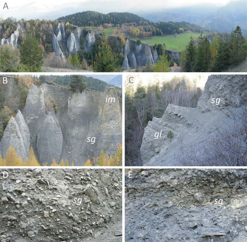
2                                                                                                        Forno M.G. et al.

op in regions with high relief-energy (Agliardi et al.,        2. MATERIALS AND METHODS
2001; Agliardi et al., 2009; Agliardi et al., 2012). Slope
deformation usually started during the Lateglacial trig-             The study areas were investigated through detailed
gered by post-glacial debutressing following the with-         geological surveys (1:10,000 or 1:5,000 scale), allowing
drawal of the glaciers and evolved during the Holocene         us to define the sedimentological features of the Quater-
(Agliardi et al., 2009). The displacement of a DSGSD is        nary sediments recognized in the field. The features of
small compared to its extent (Massironi et al., 2003) and      the Quaternary successions in different contexts along
its rate is usually around 4-5 mm/y (Agliardi et al., 2001;    the Western Alps (inside and outside DSGSD) were
Coquin et al., 2015; Varnes et al., 1990).                     described using the method by Baggio et al. (1997). The
      These long-lasting slope deformations have modi-         use of this method is finalized to have rigorous criteria
fied glacially-sculpted relief, also reducing slope inclina-   and is also used by the recent Piedmont 1:50,000 scale
tions, and have significantly contributed to the long-term     official maps of Italy.
denudation of active orogens (Agliardi et al., 2013). The            Clasts are described in this paper in terms of their
slope deformation has been linked to the interactions          volume, rather than the commonly used mean diameter
among glacially oversteepened valley flanks, weaknes-          (e.g., the Udden-Wentworth grain-size scale; Udden,
ses in the rock mass, such as schistosity, fractures,          1914; Wentworth, 1922; 1935). The study areas are
faults and high slope values (Agliardi et al., 2009;           characterized essentially by schistose lithotypes, that
Agliardi et al., 2013; Crosta, 1996; Massironi et al.,         usually form tabular clasts, with a side remarkably smal-
2003; Morelli et al., 2018; Radbruch-Hall, 1978; Zorzi et      ler than the others. Being so, the volume allows to better
al., 2014). Clearly-defined failure planes/zones are not       evaluate the clast grain size without introducing additio-
necessary for a DSGSD to develop (Dramis & Sorriso-            nal terms to describe the clast shape, as suggested by
Valvo, 1994), and the lateral margins of these phenome-        other authors (e.g., Terry & Goff, 2014).
na are often poorly defined (Agliardi et al., 2013).                 Where no significant outcrops were present, geo-
      A DSGSD will result in the formation of multiple         physical methods, such as combined electric resistivity
fractures that progressively dilate, inducing very frac-       tomographies (ERT), were applied, focusing in particular
tured rock volumes and their dislocation. Numerous             on the reconstruction of the shallow subsoil, helping to
gravitational morpho-structures, such as double ridges,        estimate the distribution and thickness of sediments
scarps, counterscarps and open trenches, are essential-        (Comina et al., 2015) (see case study 4).
ly connected to gravity, although previous tectonic frac-            Aerial photos helped us describe the morphology
tures and faults are often reactivated (Agliardi et al.,       of DSGSD sectors; these were particularly useful for
2001; Agliardi et al., 2009; Forcella & Orombelli, 1984).      obtaining an overall view and for examining sectors that
Minor landslides may occur inside the deformed rocky           were difficult to access. Topographic surveys were per-
mass, especially in its marginal sectors. The toes of          formed using "unmanned aerial vehicles" (UAVs). This
many DSGSDs lie below the present valley floors,               tool allowed us to obtain detailed aerial photos of the
where they are covered by alluvial or lacustrine fills         landscape and to create various types of maps (digital
(Agliardi et al., 2012).                                       surface models, digital terrain models with 4 cm of reso-
      Such phenomena are common in mountain belts              lution and orthophotos) which also provided evidence of
and have been extensively studied in recent decades            the morphological features of Quaternary sedimentary
(Crosta et al., 2013; Massironi et al., 2010; Ostermann        bodies in DSGSD areas (Piras et al., 2017) (see case
& Sanders, 2017). Some considerations regarding                study 8).
DSGSD areas also derive from research aimed at the
hydrogeological reconstruction of large volumes of un-         3. GEOLOGICAL SETTING OF CASE STUDIES
stable intensely fractured and loosened rocks (Binet et
al., 2009). However, while various studies have focused              The Western Alps (NW Italy) were built during the
on the genetic mechanism of DSGSDs and the in-                 Alpine orogeny. The original rocks formed in oceanic
fluence on the bedrock and valley flank morphology, the        and continental margin environments and now crop out
impact on the features of Quaternary sediment assem-           as deeply deformed and metamorphosed rocks. The
blages has been poorly investigated.                           investigated case studies are located in different valleys
      The interactions between DSGSD processes and             of the Western Alps with various geological settings,
the facies of Quaternary sediments in alpine environ-          which have already been examined by detailed geologi-
ments have potential relevance in accurate, large scale        cal surveys (Fig. 1). These valleys were deeply carved
field geological surveys. This research exclusively con-       by glaciers during the Last Glacial Maximum (LGM) and
siders the sediments of areas already involved in gravi-       were partly affected by extensive DSGSD phenomena
tational processes prior to the deposition of Quaternary       widespread in the Alps (Agliardi et al., 2009; Forno et
bodies, as their sedimentological features can be in-          al., 2013a; 2013b) and other mountain areas (Coquin et
fluenced by DSGSDs.                                            al., 2015).
      This research intends to contribute to the definition          The Quaternary successions in the study areas are
of some guidelines for the field identification, interpreta-   essentially fed by metamorphic bedrock consisting of
tion and mapping of Quaternary successions in DSGSD,           schistose lithotypes, with prevailing calcschist and sub-
although taking into consideration the influence of local      ordinate micaschist, greenschist and gneiss. In detail,
geological and geomorphological conditions in different        case study 1 (La Saxe) regards the phyllite of the Ultra-
areas of the Alps.                                             helvetic Domain and the gneiss of the Mont Chetif tec-
                                                               tonic slice, which involves brittle deformed rocks ar-
DGPV effects on Quaternary sediments 3
ranged along the Penninic Frontal Thrust (Elter,
1987). Case study 2 (La Salle) concerns an
Upper Carboniferous succession consisting of
coal-bearing slate and meta-clastic sediments.
Here, the effects of gravitational deformation on
tributary torrential sedimentation were investi-
gated by Polino et al. (2015).
Case studies 3, 5, 7, and 8 (Fallére south-
ern slope, Bardonecchia, Fenestrelle and Ger-
manasca Valley) are developed in prevalent
calcschist, with minor bodies of mafic and ultra-
mafic rocks (e.g., meta-peridotite, serpentinite,
meta-gabbro, and green-schist) strongly de-
formed along the regional schistosity and re-
ferred to the ophiolitic Combin-like units of the
Upper Piedmont Zone (Polino et al., 2015). We
focused on the Becca France ridge (Fallére
southern slope, case study 3) where numerous
landforms related to DSGSD (i.e., doubled
ridges, minor scarps and trenches) were among
the predisposing factors of a large historical
rock avalanche, dating back to 1564 AD (Forno
et al., 2012a). The same DSGSD has also been
described in the surrounding Plan di Modzon
area (Forno et al., 2013a), where the presence
of gravitational trenches and the evolution of
minor scarps on lacustrine and palustrine sedi-
mentation have been detected by geophysical
approaches (Comina et al., 2015). Some geo-
logical information is also reported for the Susa
Valley (Bardonecchia, case study 5), where a
significant spring is fed by strongly fractured
bedrock (calcschist) (De Luca et al., 2015). A
DSGSD in the Chisone Valley (Fenestrelle,
case study 7) is reported as a predisposing
factor for the occurrence of thick landslides that
hindered the T. Chisone flow (Carraro & Forno,
1981; Fioraso & Baggio, 2013).
DSGSD phenomena were also well inves-
tigated in a Chisone Valley tributary
(Germanasca Valley), also using geomatics
techniques, highlighting numerous gravitational
morpho-structures that split the glacial sediment
bodies, which resulted in numerous isolated Fig. 1 - The investigated areas are located in the Western Alps (NW Italy) and
flaps (Forno et al., 2011; Forno et al., 2012b; refer to different geological contexts. Case studies (1) La Saxe, (2) La Salle, (3)
Piras et al., 2017) (case study 8). Fallére southern slope and (4) Renanchio Basin are located in the Dora Baltea
Valley. Case studies (5) Bardonecchia and (6) Moncellier are located in the
Case study 4 (Renanchio Basin) is located Dora Riparia Valley. Case studies (7) Fenestrelle and (8) tributary Germanasca
in eclogite micaschist and gneiss with minor Valley are located in the Chisone Valley.
bodies of marble, calcschist and mafic rocks
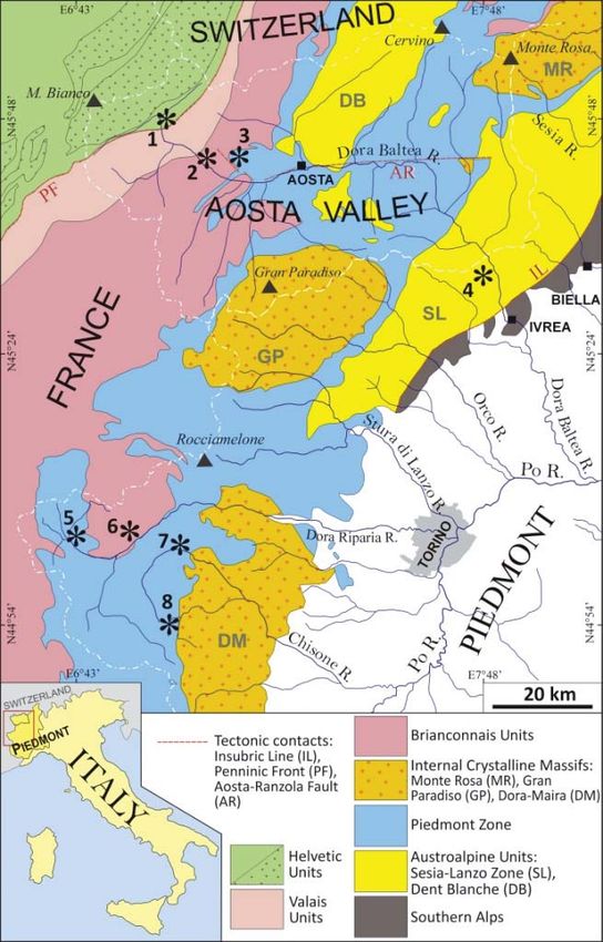
referred to as Austroalpine Units (Sesia-Lanzo Zone). regarded as connected to an aquifer hosted by the frac-
This area, which is strongly influenced by both DSGSDs tured and loosened rocks of a DSGSD (De Luca et al.,
and the glacial and torrential evolution of the lateral 2009).
Renanchio Valley, is significant for the interconnection
between gravitational deformation and hydrogeological 4. RESULTS
setting. Specifically, a spring with high water discharge
(average 160 ls-1) located in the area is supplied by 4.1. Influences of DSGSDs on subglacial sediments
groundwater hosted in the loosened bedrock linked to A significant example of subglacial sediments
this deformation (De Luca et al., 2015; De Luca et al., (lodgement till) in a DSGSD area is visible on the west-
2019; Lasagna et al., 2013). ern slope of the Germanasca Valley, E of the Balma
Finally, case study 6 (Moncellier) includes mica- village along the T. Rodoretto tributary (case study 8) (a
schist with some meta-conglomeratic levels of the Am- in Fig. 2). The outcrop is approximately 70 m wide and
bin Complex in the Ambin Massif (Grand Saint Bernard 10 m high and does not reach the bedrock (Fig. 3A).
Nappe). The springs, as in previous cases, have been The top of the outcrop has a regular surface, represent-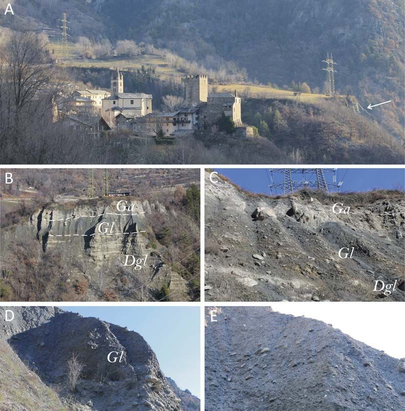
4                                                                                                                     Forno M.G. et al.

Fig. 2 - Topographic map of case study 8, in the Germanasca Valley. Location of the examples reported in the text: subglacial sediments
(a) and ice-marginal sediments (b). The yellow dotted line marks the edge of the investigated DSGSD area.

ing the side of the glacial valley.                                     Baltea River, filled by a thick sedimentary succession
      These sediments are formed by tabular clasts of                   (case study 3) (b in Fig. 4).
various sizes mixed in a subordinate unsorted matrix                          This Gaboè stretch appears entrenched in a previ-
(Fig. 3B). The decimetric clasts (10 cm3-0,5 m3) are                    ous incision of the Dora Baltea Glacier (Fig. 5A). Evident
numerous in the whole outcrop, while boulders of great                  badlands on the southern slope allow us to observe a
size (essentially 0,5-3 m3) are few and more abundant in                700 m-wide and 30-35 m-high outcrop, showing a suc-
the lower band of the outcrop, where rare boulders, with                cession of glaciolacustrine (gl, 10 m of visible thickness),
up to a 70 m3 volume, are also observed (Fig. 3D). The                  subglacial (lodgement till) (sg, 15-18 m thick) and ce-
clasts have poor roundness: the centimetric fragments                   mented ice-marginal sediments (im, 6 m thick) (Fig. 5 B
are angular, while the decimetric and metric boulders                   and C).
are from subangular to subrounded. The fragments and                          The subglacial sediments are dominated by abun-
boulders show a preferential dip of 30-35°, according to                dant clasts mixed in a poor matrix (Fig. 5D). The body
the slope of the glacial valley (Fig. 3C). The petrogra-                consists of decimetric thick layers of massive sediments,
phic composition of the clasts is very monotonous, es-                  variably inclined 10-30° towards the SE (Fig. 5C).
sentially comprising calcschist (phyllitic and carbonate)               Groups of strata with little difference in orientation and
with subordinate prasinite, basaltic metabreccia, quartz-               dip are visible, separated by unconformable low to mid-
ite and rare marble, according to the local bedrock fed                 angle erosional surfaces. The clasts have various sizes
by the high Rodoretto Valley. Some clasts preserve                      mostly comprising centimetric (10 cm3) and decimetric
carbonate patinas suggesting poor cementation of sedi-                  fragments (10 cm3-0,5 m3), with rare boulders (up to 1
ments.                                                                  m3), locally concentrated in the low band of sediments
      The matrix, which is variably present (10-20%), is                (Fig. 5B). The clasts are essentially angular with very
mostly subordinate to the clasts, but enough to deter-                  subordinate subrounded shapes (Fig. 5E). The petro-
mine the matrix-supported texture, responsible for the                  graphic composition of the clasts is monotonous, formed
poor permeability (Fig. 3E). The matrix essentially con-                by prevailing calcschist with subordinate quartzite.
sists of very abundant millimetric to centimetric rock                        The matrix, which is variably present (10-20%), is
fragments (10 cm3) with subordinate fine sand and silt.                mainly formed of millimetric to centimetric rock frag-
These sediments show high consolidation. The un-                        ments (10 cm3) with a lower silty component and ap-
weathered clasts and matrix (grey colour) and location                  pears subordinate to clasts (Fig. 5D). These matrix-
in the valley floor can agree with the reference to the                 supported sediments mostly show high consolidation
last glaciation.                                                        and not appear cemented, despite the occurrence of
      Another example of subglacial sediments in the                    surficial carbonate patinas, supplied by the overlying
DSGSD context is visible near Saint Nicolas village                     cemented ice-marginal sediments. The prevailing grey
along the Gaboè Valley, a northern tributary of the Dora                colour and the unweathered clasts agree with the refer-
DGPV effects on Quaternary sediments                                                                                                   5

Fig. 3 - Outcrop of subglacial sediments (lodgement till) E of Balma village (case study 8). A) Panoramic view of the outcrop seen from the
east: the regular morphology of the original preserved glacial slope is evident at the top of the sediments (slope of 26°). B) The sediments
are formed by clasts of various sizes mixed to in a poor matrix. C) The clasts have a poor roundness and show a preferential arrangement
according to the glacial slope. D) Boulders of great size (volume up to 70 m3) are relatively abundant in the lower band of the outcrop. E)
Detail of the outcrop in which the relationship matrix/clasts is observed.

ence to the last glaciation.                                               normally very subordinate and plunged in the matrix
      The uncommon features of the subglacial sedi-                        with faceted shapes and are subangular to subrounded.
ments in the investigated DSGSD areas can be evaluat-                      The petrographic composition of the clasts is usually
ed comparing them with their analogues outside                             representative of the entire basin, except for the bottom
DSGSD areas, which are characterized by a strong                           which can be enriched by the local bedrock. Typical
predominance of the sandy-silty matrix (Tab. 1). Only                      pebbles (i.e., faceted, polished and striated pebbles) are
locally, under some conditions (slightly weathered bed-                    also common. These sediments are normally overcon-
rock with a large amount of available debris for tectonic                  solidated due to ice loading (Goldthwait & Matsch,
fracturing), could the matrix be poor. The clasts are                      1988).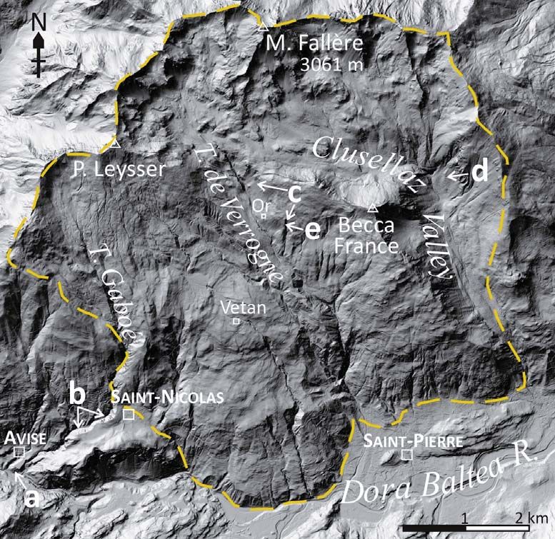
6                                                                                                                          Forno M.G. et al.

Fig. 4 - Topographic map of case study 3, located on the northern slope of the Aosta Valley in the P. Leysser DSGSD. Locations of the
examples reported in the text: lacustrine sediments (a), subglacial sediments (b), debris (c), avalanche sediments (d) and colluvial (e). The
yellow dotted line marks the edge of the investigated DSGSD area.

       In contrast, the subglacial sediments (lodgement                     - Colle San Carlo Subsynthem).
till) in the investigated DSGSD case studies usually
show significantly less matrix (Fig. 5E), a greater abun-                   4.2. Influences of DSGSDs on ice-marginal and su-
dance of various size clasts (Fig. 3D) and essentially                      praglacial sediments
angular clasts with the absence of faceted, polished and                           An exemplificative and well-exposed outcrop of ice-
striated pebbles. Moreover, the clasts show a local and                     marginal and supraglacial sediments is located on the
monotonous petrographic composition derived from the                        western slope of the Germanasca Valley, approximately
bedrock involved in DSGSD phenomena. The typical                            700 m SSE of Bergeria Balma along the T. Rodoretto
overconsolidation of subglacial sediments outside                           tributary (case study 8) (b in Fig. 2). This outcrop is ap-
DSGSD areas is also less evident in DSGSD areas                             proximately 25 m wide and 30 m high (Fig. 6A), reaching
caused by the scarcity of the sandy-silt matrix. The                        the bedrock in its southern sector allowing to evaluate
prevalence of a coarse fraction in the matrix also leads                    the overall thickness of these sediments of approximate-
to a greater permeability and consequent local car-                         ly 30 m and covered by colluvium in the lower band (Fig.
bonate cementation (Fig. 5D).                                               6B). These sediments crop out in the internal flank of the
       The peculiar features of the described subglacial                    frontal-lateral sector of a right moraine.
sediments located in the Fallére southern slope (case                              The ice-marginal sediments are essentially formed
study 3) (Fig. 5), referred to the late LGM, were already                   by centimetric to decimetric clasts (the clast size essen-
described as characterized by the prevailing presence                       tially varies between 5 cm3 to some dm3) mixed in a
of angular clasts made of local lithotypes (calcschist and                  sandy-silty matrix (Tab. 1) (Fig. 6C). The sediments also
marble) with abundant sandy-gravelly matrix. Subroun-                       contain rare boulders up to 1 m3 in size. The clasts dis-
ded allochthonous clasts are also present, but in lesser                    play subangular to angular shapes (Fig. 6C) and have a
amount than usual glacial sediments (Polino et al., 2015                    monotonous petrographic composition exclusively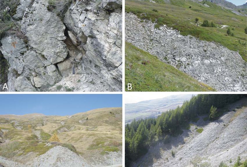
DGPV effects on Quaternary sediments                                                                                                   7

Fig. 5 - Glacial succession in the Gaboè Valley, SW Saint Nicolas (case study 3). A) The Gaboè Valley seen from the NW, characterized
by evident badlands, entrenched in a Dora Baltea glacial valley floor (green valley). B) Succession of subglacial (lodgement till) (sg, dark
grey) and cemented ice-marginal (im, yellow-grey) sediments; the regular morphology of a moraine is evident at the top of the sediments.
C) Succession of well-stratified glaciolacustrine (gl) and overlying massive to stratified subglacial sediments (sg). D) Subglacial sediments
formed by prevailing small subangular clasts mixed in a poor matrix. E) Details of the clast-rich subglacial sediments.

formed by calcschist and subordinate marble, repre-                         colour and the unweathered clasts also suggest a refe-
sentative of the local bedrock. Numerous clasts show                        rence to the last glaciation.
arrangement towards the E (Fig. 6D), defining inclined                           The uncommon features of the ice-marginal and
bedding according to a right lateral moraine. The poor                      supraglacial sediments in the investigated DSGSD a-
matrix (essentially ranging from 10% and 20%) is un-                        reas can be evidenced by comparing them with the
sorted and rich in millimetric rock fragments with a very                   same sediments outside DSGSD areas. These last are-
subordinate silty component (Fig. 6E). The sediments                        as typically have abundant large and giant boulders of
essentially have a matrix-supported texture and are                         various petrographic compositions (Dreimanis, 1988;
normally consolidated and weakly cemented. The grey                         Goldthwait & Matsch, 1988), although a remarkable
8                                                                                                                          Forno M.G. et al.

Fig. 6 - Outcrop of the ice-marginal sediments SSE of Bergeria Balma (case study 8). A) Panoramic view of the outcrop seen from the
west: the morphology of a moraine is evident at the top of the sediments (white arrows indicate the moraine ridge). B) The upper part of the
outcrop shows ice-marginal sediments (im) lying on the bedrock (bd), while these sediments are covered by colluvium in the lower band
(c). C) Angular shape and arrangement of most clasts towards the east (right). D) Details of the abundant clasts. E) Poor amount of matrix.

local fraction can occur. Such boulders are defined as                          Carbonate fluids circulating in the ice-marginal
“erratic” and are essentially different than the local bed-                sediments are recognized to promote their cementation
rock, possibly deriving from remote regions. Moreover,                     and even deposition of travertine. Such fluids are com-
these sediments are also characterized by a large                          mon in DSGSD areas characterized by the presence of
amount of sandy-silty matrix, often prevailing.                            deeply fractured carbonate bedrock. As an example, the
      In contrast, the ice-marginal and supraglacial sedi-                 Fallére southern slope (case study 3) is characterized by
ments in the DSGSD case studies show a scarcity of                         a great concentration of travertine (Polino et al., 2015;
large boulders (Fig. 6A) caused by the extreme fractur-                    Forno et al., 2016).
ing of the bedrock and a great abundance of millimetric-
centimetric clasts. The petrographic composition, which                    4.3. Influences of DSGSDs on torrential sediments
is mainly local, represents another difference with analo-                       The best outcrop of torrential sediments is on the
gous sediments outside DSGSD areas that can also                           northern slope of the Aosta Valley, along the Dora Bal-
contain many clasts of various lithotypes. The scarcity of                 tea fluvial incision into the wide La Salle fan (case study
matrix favours a carbonate cementation, which increas-                     2) (Fig. 7A). This outcrop, approximately 200 m wide
es the differences with the ice-marginal and supraglacial                  and 30 m high, is covered by colluvium in the lower
facies outside DSGSD areas.                                                band. The typical flat morphology of a large alluvial fan,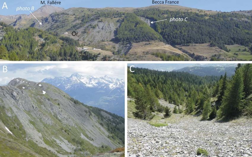
DGPV effects on Quaternary sediments                                                                                                     9

Fig. 7 - Outcrop of the torrential sediments S of La Salle village (case study 2). A) Morphology of the wide La Salle alluvial fan, supplied by
a small basin (a), view seen from the SW (outcrop indicated by the white arrow). The yellow dotted line marks the edge of the DSGSD
area. B) Subangular shape of most clasts forming torrential sediments mixed in an abundant matrix. C) Details of the not very evident
inverse graded bedding.

despite being supplied by the small d'Echarlod basin,                        comparing them with torrential sediments outside
develops at the top of sediments (Fig. 7A).                                  DSGSD areas, which usually have abundant rounded to
       The torrential sediments are essentially formed by                    subrounded pebbles and cobbles, centimetric to deci-
centimetric to decimetric clasts (the clast size varies                      metric in size, mixed in a poor sorted, sandy matrix de-
between 5 cm3 to some dm3) mixed to an abundant                              fining a clast-supported texture (Thorne et al., 1987).
matrix (Tab. 1) (Fig. 7B). The clasts have subangular                        Moreover, the torrential sediments show evident cross-
shapes with smooth edges (Fig. 7B) and a petrographic                        bedding with local imbricate clasts.
composition exclusively formed by gneiss, grey marble,                             In contrast, the torrential sediments in the DSGSD
micaschist, graphitic schist and quartzite, representative                   case studies show a scarcity of rounded pebbles and
of the catchment basin bedrock. The clasts define an                         cobbles (Fig. 7B). These sediments are characterized by
inverse graded bedding (Fig. 7C), despite not being                          relatively few sub-angular decimetric clasts, a great
evident, suggesting an environment also fed by debris-                       abundance of millimetric-centimetric angular clasts and
flow phenomena. The relatively abundant matrix, essen-                       sandy matrix, which also favour carbonate cementation.
tially ranging from 20% to 30%, is partly formed by milli-                   The scarcity of coarse-grained clasts determines the
metric rock clasts with a subordinate unsorted sandy                         lack of evident bedding and the texture between clast-
component. The dark grey colour of the matrix is essen-                      supported and matrix-supported.
tially due to the remarkable graphitic schist component
(Fig. 7C). These sediments essentially have a matrix-                        4.4. Influences of DSGSDs on debris (scree)
supported texture, appearing normally consolidated and                             The debris in the DSGSD investigated case studies
weakly cemented.                                                             shows some differences compared to the debris outside
       The peculiar features of the torrential sediments in                  DSGSD areas. An approximately 300 m wide and 100 m
the investigated DSGSD areas can be highlighted by                           high outcrop of these sediments (Fig. 8A) is located on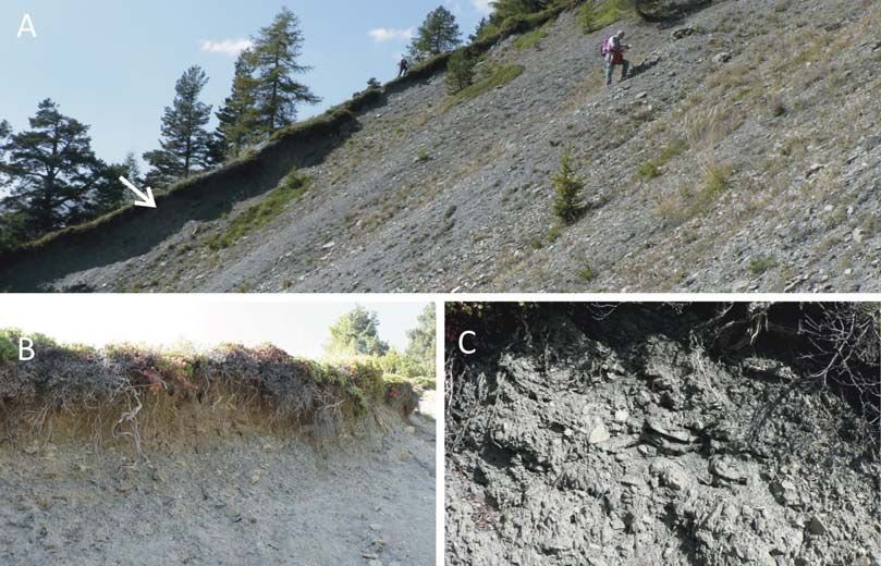
10
                                                                                                                           Forno M.G. et al.

Fig. 8 - Outcrop of the debris NW of Verrogne village (case study 3). A) Panoramic view of the slope seen from the south. B) Morphology
of the slope at the top of the sediments, consisting of a debris talus, seen from the west. C) Angular tabular shape of centimetric clasts
forming the debris.

the northern slope of the Aosta Valley along the T. Ver-                  tributary (Gaboè R.) (case study 3) (a in Fig. 4). This
rogne tributary, 2 km NW of Verrogne village (case                        outcrop is exposed in the deep incision due to the cur-
study 3) (c in Fig. 4). The topographic surface at the top                rent hydrographic network (Dora Riparia and Gaboè
of the outcrop shows a regular SW-sloping morphology,                     rivers), with a depth of approximately 45 m (Fig. 9B).
according to a talus slope (Fig. 8B).                                     The top of the outcrop shows S-sloping flat morphology
      The outcropping debris is formed by centimetric                     entrenched in the Gaboè R. incision, suggesting a tor-
clasts, with rare decimetric elements (Tab. 1) (Fig. 8C).                 rential fan of this watercourse (Fig. 9A).
The clasts and millimetric fragments are angular and                             This outcrop, approximately 40 m high and 200 m
essentially display an irregular tabular shape and have a                 long, allows the observation of a succession of three
monotonous petrographic composition, formed by pre-                       overlapping sedimentary bodies, a glaciolacustrine body
vailing calcschist with rare quartzite, strictly depending                (27 m of visible thickness), a lacustrine body (5 m thick)
on the composition of the upper slope. The debris is                      and an alluvial body (6 m thick) (Fig. 9B). The lower and
characterized by an open texture and structures ranging                   the upper bodies contain clasts of various petrographic
from a massive to an inclined bedding and appears                         compositions (comprising the Monte Bianco granite)
unconsolidated and locally cemented. The large calc-                      referred to the Dora Baltea Valley (interpreted as directly
schist component determines the grey colour of the                        supplied by the Dora Baltea Valley for the lower body
sediments.                                                                and as reworked glacial Dora Baltea sediments for the
      The increasing of potential debris and small rock-                  upper body) and therefore are essentially not connected
falls also highlighted in the Cenischia Valley, especially                with DSGSD areas. The intermediate body is, on the
in the uppermost sectors of the catchments, was con-                      contrary, rich in local clasts, suggesting an exclusively
nected to the presence of well-developed DSGSD re-                        local supply by the Gaboè basin, developed into the P.
sulted in producing debris and torrential deposits up to                  Leysser DSGSD. Therefore, it can be used as an exam-
dozens of meter thick (Coviello et al., 2015).                            ple of lacustrine sediments supplied by a DSGSD area.
      The debris in the investigated DSGSD areas is                              The lacustrine body has a basal surface consisting
usually formed by centimetric clasts, whereas outside                     of a weakly N-dipping concave erosional surface, with a
DSGSD areas, debris is usually decimetric in size (Tab.                   counter-slope trend (Fig. 9D). These sediments are
1).                                                                       formed by centimetric to decimetric clasts (the size es-
                                                                          sentially varies between a few cm3 to a few dm3) mixed
4.5. Influences of DSGSDs on lacustrine sediments                         in an abundant unsorted matrix, mainly comprising milli-
      A significant outcrop of lacustrine sediments in the                metric angular tabular rock fragments and a poor sandy-
DSGSD areas is located on the northern slope of the                       silty component (Tab. 1) (Fig. 9C). The clasts essentially
Aosta Valley, 150 m SE of Avise village, at the conflu-                   are subangular to subrounded (Fig. 9E) and have a mo-
ence between the Dora Baltea incision and its northern                    notonous petrographic composition, formed by prevail-
11
DGPV effects on Quaternary sediments
Fig. 9 - Outcrop of the lacustrine sediments 150 m SE of Avise village (case study 3). A) The top of succession, seen from the west, shows
an alluvial fan typical morphology (arrow indicates the outcrop). B) A succession, seen from the south, of Dora Baltea glaciolacustrine
(Dgl), Gaboè R. lacustrine (Gl) and alluvial (Ga) bodies. C) Details of the sedimentary succession. D) Basal surface of lacustrine sedi-
ments (Gl). E) Relatively coarse-grained facies of the Gaboè lacustrine sediments formed by angular clasts mixed in a sandy matrix of dark
grey colour.
ing calcschist with rare prasinite and quartzite, repre- frequently have a sandy-silty texture, as well as a more
sentative of the local bedrock of the Gaboè Basin. varied petrographic composition and high roundness of
These sediments have matrix-supported texture and clasts.
bedding weakly inclined towards the south, according to In contrast, the lacustrine sediments in the DSGSD
a foreset body deposited in a lacustrine environment, case studies are essentially gravel with a great abun-
defined by alternating clast-rich and matrix-rich levels. dance of millimetric angular tabular rock fragments and
The sediments also appear normally consolidated and various amounts of sandy-silty matrix.
have a dark grey colour, resulting from the large calc-
schist component (Fig. 9E). 4.6. Influences of DSGSDs on colluvial sediments
The uncommon features of the lacustrine sedi- A valuable outcrop of colluvial sediments, approxi-
ments in the investigated DSGSD areas can be evi- mately 50 m wide and 3 m high (along an erosional
denced by comparing them with the same sediments scarp), is located on the northern slope of the Aosta
outside DSGSD areas that are usually fine-grained and Valley along the T. Verrogne tributary, 2 km NW of Ver-12 Forno M.G. et al.
Fig. 10 - Outcrop of the colluvial sediments NW of the Verrogne village (case study 3). A) View of the outcrop (arrow) seen from the east
and morphology of the slope at the top of the sediments. B) Facies of the grey investigated colluvial sediments and of the brown colluvial
sediments deriving from reworking of glacial sediments. C) Details of angular tabular centimetric clasts mixed in a subordinate matrix.
rogne village (case study 3) (e in Fig. 4). The top of the 4.7. Influences of DSGSDs on avalanche sediments
outcrop, which is characterized by a brown cover of A well-exposed outcrop of avalanche sediments
other colluvial sediments, likely reworked glacial sedi- (Fig 11A) is located on the northern slope of the Aosta
ments, shows a regular S-sloping morphology (Fig. Valley, 3 km NNW of the Sarre village, along the up-
10A). stream scarp of a mountain pasture road in the tributary
The outcropping colluvial sediments, at least 2-3 m Clusellaz Valley (case study 3) (d in Fig. 4). The topo-
thick (Fig. 10B), are formed by small clasts mixed in a graphic surface at the top of the outcrop shows a regular
matrix rich in millimetric rock fragments (Tab. 1) (Fig. SW-sloping morphology, according to a T. Clusellaz
10C). The clasts, essentially centimetric in size with rare avalanche fan (Fig. 11A). This outcrop, which is approxi-
decimetric elements, and millimetric fragments of the mately 12 m high and 60 m long, allows the observation
matrix are angular and have an irregular tabular shape. of a succession of two sedimentary bodies, a low sub-
The clasts and fragments have a monotonous petro- glacial (5 m of visible thickness) and an upper avalanche
graphic composition, with prevailing calcschist and rare body (7 m thick) (Fig. 11B).
quartzite, strictly depending on the lithology of the upper In detail, the lower body contains clasts of a vari-
slope. The colluvial sediments are characterized by a ous petrographic compositions referred to the Dora Bal-
clast- to matrix-supported texture and structures ranging tea Valley and is therefore essentially not connected
from massive to inclined bedding according to the slope. with DSGSD areas. The upper body is, on the contrary,
The sediments appear unconsolidated, locally cemented rich in local clasts, suggesting an exclusive supply by
and of grey colour connected to their petrographic com- the Clusellaz basin developed into the P. Leysser
position. DSGSD, and it can be used as an example of avalanche
The colluvial sediments in the investigated DSGSD sediments supplied by a DSGSD area.
areas have partly uncommon features with respect to The avalanche body has a basal surface consisting
the same sediments outside DSGSD areas, which usu- of a convex surface in the cross-section, visible along
ally consist of sand, slightly gravelly and silty, with rare the road scarp, connected with a previous ridge shaped
clasts and evident matrix-supported textures. In con- in the subglacial sediments (Fig. 11B). The avalanche
trast, the colluvial sediments in the DSGSD case studies sediments are formed by centimetric to decimetric clasts
are silty sandy gravel formed by prevailing centimetric (the clast size essentially varies between some cm3 to
angular clasts of local petrography. The poor unsorted some dm3) mixed in a poor unsorted matrix, essentially
matrix (mainly formed by angular tabular millimetric formed by millimetric angular tabular rock fragments and
fragments) is responsible for the various textures, i.e., a scarce sandy-silty component (Tab. 1) (Fig. 11B). The
matrix or clast-supported. clasts essentially have angular to subangular shapesDGPV effects on Quaternary sediments 13
ding, according to the fan surface and defining a body
deposited in an avalanche environment. The sediments,
which have a grey colour, also appear normally consoli-
dated and weakly cemented.
The partly uncommon features of the avalanche
sediments in the investigated DSGSD areas can be
evaluated by comparing them with the avalanche sedi-
ments outside DSGSD areas, which are usually matrix-
rich with subordinate clasts, defining a matrix-supported
texture. In contrast, the avalanche sediments in the
DSGSD case studies consist of centimetric up to deci-
metric angular clasts of local lithotypes with a poor ma-
trix containing millimetric angular tabular rock fragments,
forming a clast-supported texture (Jomelli & Francou,
2000; Luckman et al., 1977; Matthews et al., 2011).
5. DISCUSSION
The various facies observed in the investigated
DSGSD cases show sedimentological features that are
partly very different and partly common to those outside
DSGSD areas regarding the grain size, clast shape and
roundness, clast abundance and petrographic composi-
tion and the amount and texture of the matrix (Tab. 1).
Regarding the anomalous features in the investi-
gated case studies, the subglacial facies is characte-
rized by the great abundance of small subangular to
angular clasts mixed in a matrix mainly formed by milli-
metric rock fragments, resulting in a coarse-grained
texture. This lithofacies is very different compared to that
of traditional subglacial sediments (outside DSGSD are-
as), which are characterized by an essentially fine tex-
ture, with a prevailing fine sandy-silty matrix, and sub-
rounded, smoothed, polished and striated pebbles.
Additionally, the ice-marginal sediments have a
peculiar texture in the investigated case studies with an
abundance of millimetric to metric fragments, scarcity of
fine sand and silt in the matrix and absence or rareness
of large boulders (larger than metric in size). These
characteristics are unusual compared to those of tradi-
tional ice-marginal sediments outside DSGSD areas,
which generally have many large boulders and an abun-
dant fine matrix.
The occurrence of many small angular rocky frag-
ments of local lithotypes also characterizes the colluvial,
avalanche, lacustrine and debris sediments outcropping
in the investigated DSGSD areas, which are partly
coarser than traditional sediments (colluvial, avalanche,
lacustrine) or finer (debris) than traditional sediments.
Finally, the prevalence of small angular rock frag-
ments is observed in DSGSD examples both in the ca-
ses in which the traditional sediments are usually fine
Fig. 11 - Wide outcrop 3 km NNW of Sarre village (case study (subglacial and lacustrine sediments) and in the cases in
3). A) Succession of subglacial (sg) and avalanche (av) sedi-
which the sediments usually contain very large boulders
ments. This last body forms an extended avalanche fan. B)
Basal surface of avalanche sediments (arrows) that cover a (ice-marginal sediments).
glacial ridge. C) Detail of coarse grained facies of the avalanche This look can be the consequence of high bedrock
body visible above the subglacial sediments. fracturing despite the fractures not being homogenously
distributed throughout the whole rock volume, which has
(Fig. 11C) and a monotonous petrographic composition both highly fractured and completely loosened sectors
(prevailing calcschist and prasinite with rare quartzite (Fig. 12). This conclusion applies only for DSGSDs that
and cellular dolomite) representative of the local bed- evolved before or at the same time as the deposition of
rock outcropping on the upper slope. These sediments Quaternary successions, which are therefore fed by
have a clast-supported texture and 20° SW dipping bed- fractured bedrock, while gravitational phenomena that14 Forno M.G. et al.
Fig. 12 - Various fracturing of the bedrock in DSGSD areas. Fractured (A, Moncellier, case study 6) or completely loosened bedrock (B, Or
village on the Fallére southern slope, case study 3). The fractured bedrock can simulate ice-marginal sediments forming a moraine (C) or
debris (D) (western side of the Becca France ridge, on the Fallére southern slope, Dora Baltea Valley, case study 3).
evolved subsequently do not affect the sedimentary studied DSGSD areas is the monotonous petrographic
features but only dislocate and deform the geological composition of most of the clasts caused by a prevailing
bodies, influencing their distribution and conservation local supply. This composition differs especially for gla-
degree. cial sediments with respect to that of traditional facies
Fracturing and slackening cause a downgrading of (outside DSGSD areas), which are usually rich in vari-
the geo-mechanical properties of the bedrock, favouring ous lithotypes representative of the entire glacial basin,
the high production of angular rock fragments of local although the local component can sometimes be signifi-
lithotypes. The fragments usually have flattened shapes cant for ice-marginal sediments or near the bottom for
in loosened schistose rocks, which are the prevalent subglacial sediments. However, if the glacier or the wa-
lithotypes in the study area. It should be emphasized tercourse has a basin upstream of the DSGSD areas,
that a fractured bedrock is not exclusive to DSGSDs some subordinate allochthonous clasts can be present.
and can also derive from a strong tectonization linked to The abundance of rock fragments in the DSGSD
a brittle deformation zone. examples can also promote high permeability in the
Furthermore, the production of small rock frag- sediments and consequent carbonate cementation due
ments can be favoured by the occurrence of many grav- to the various contents of CaCO3 in water, depending on
itational morpho-structures, which are mainly represen- bedrock composition. In contrast, in traditional sedi-
ted by steep rock walls along minor scarps and elonga- ments outside DSGSD areas, carbonate cementation
ted depressions corresponding to trenches. These slope can be hindered by normal abundance of silty matrix.
irregularities favour their strong erosion by various exo- The high fracturing of bedrock in DSGSDs produ-
genous agents. The removal of bedrock fragments is ces large sectors with juxtaposed centimetric angular
essentially due to glaciers, during glacial phases, and to fragments that can be confused with Quaternary sedi-
watercourses, running water, snow avalanches and ments (Fig. 12C). For example, the loosened bedrock
gravity during the post-glacial period. Moreover, the can be, at first glance, totally mistaken as debris, despite
morphological renewal of these walls, linked to the pro- the absence of a source upstream (Fig. 12D). More ac-
gressive reactivation of morpho-structures, further in- curate observations indicate that the foliation inside indi-
creases the availability of centimetric rock fragments. vidual fragments appears prevalently aligned with the
Another significant feature of the sediments in the regional schistosity and that all fragments have theDGPV effects on Quaternary sediments 15 Tab. 1 - Sedimentological features of the different facies of Quaternary sediments in the mountain areas.
16                                                                                                         Forno M.G. et al.

same attitude of schistosity. Consequently, these frac-         paper.
tured patches are directly shaped in the bedrock and
can be considered “in situ” (Fig. 12C).                         REFERENCES
      This research started to solve well-known difficul-
ties in the survey and mapping of Quaternary succes-            Agliardi F., Crosta G.B., Zanchi A. (2001) - Structural
sions in DSGSD areas of the Western Alps since the                    constraints on deep-seated slope deformation
uncommon facies of some sediments in these areas can                  kinematics. Eng. Geol., 59(1-2), 83-102.
hinder their identification. In detail, recognizing the sedi-         Doi: 10.1016/S0013-7952(00)00066-1
ments as such is often hard in this context because the         Agliardi F., Crosta G.B., Zanchi A., Ravazzi C. (2009) -
sediments can sometimes be confused with loosened                     Onset and timing of deep-seated gravitational
bedrock and it is difficult to distinguish between the dif-           slope deformations in the eastern Alps, Italy. Geo-
ferent types of sediments. For example, subrounded                    morphol., 103, 113-12.
faceted pebbles formed by allochthon lithotypes, which                Doi: 10.1016/j.geomorph.2007.09.015
normally characterize subglacial sediments, do not oc-          Agliardi F., Crosta G.B., Frattini P. (2012) - Slow rock-
cur, and consequently, these sediments cannot be rec-                 slope deformation. In: Clague J.J., Stead D. (eds.)
ognized and mapped. Loosened bedrock or soils or                      Landslides Types, Mechanisms and Modeling.
colluvia connected to bedrock weathering/reworking are                Cambridge Univers. Press, 207-221.
alternatively reported (for example Carraro et al., 2002;             Doi: 10.1017/CBO9780511740367.019
Polino et al., 2002). Consequently, some DSGSD areas            Agliardi F., Crosta G.B., Frattini P., Malusà M.G. (2013)
seem strangely poor in Quaternary sediments, while the                - Giant non-catastrophic landslides and the long-
extreme fracturing of bedrock should have favoured the                term exhumation of the European Alps. Earth
deposition of surficial sediments (Forno et al., 2016).               Planet. Sci. Lett., 365, 263-274.
                                                                      Doi: 10.1016/j.epsl.2013.01.030
6. CONCLUSIONS                                                  Alberto W., Giardino M., Martinotti G., Tiranti D. (2008) -
                                                                      Geomorphological hazards related to deep disso-
      This research derives from extensive field expe-                lution phenomena in the Western Italian Alps: di-
rience in the survey of Quaternary continental succes-                stribution, assessment and interaction with human
sions in the Western Alps. Some case studies suggest                  activities. Eng. Geol., 99 (3-4), 147-159.
that the Quaternary sediments located in DSGSD areas                  Doi: 10.1016/j.enggeo.2007.11.016
are often unusual and partly different from their ana-          Ambrosi C., Crosta G.B. (2006) - Large sackung along
logues in successions outside DSGSD areas. The sedi-                  major tectonic features in the Central Italian Alps.
ments in the reported examples proved to be strongly                  Engin. Geol., 83, 183-200.
enriched in centimetric angular rock fragments, their                 Doi: 10.1016/j.enggeo.2005.06.031
presence being promoted by the high degree of rock              Baggio P., Bellino L., Carraro F., Fioraso G., Gianotti F.,
fracturing and the numerous gravitational scarps typical              Giardino M. (1997) - Schede per il rilevamento
of DSGSD areas.                                                       geologico delle formazioni superficiali. Il Quater-
      The differences between the sedimentological                    nario, It. Journ. Quatern. Sci., 10(2), 655-680.
features observed in the investigated case studies and          Bollati I.M., Masseroli A., Mortara G., Pelfini M., Trom-
those outside DSGSD areas vary according to the depo-                 bino L. (2019) - Alpine gullies system evolution:
sitional environment. Debris, avalanche and torrential                erosion drivers and control factors. Two examples
sediments, which are typically made of angular clasts,                from the western Italian Alps. Geomorphology,
show almost equal facies both inside and outside                      327, 248-263.
DSGSD areas. In contrast, sediments that are normally                 Doi: 10.1016/j.geomorph.2018.10.025
fine (i.e., subglacial, colluvial and lacustrine deposits) or   Binet S., Spadini L., Bertrand C., Guglielmi Y., Mudry J.,
very coarse (i.e., glacial deposits) show low textural                Scavia C. (2009) - Variability of the groundwater
variability inside the DSGSD area, giving rise to a sort of           sulfate concentration in fractured rock slopes: a
“facies convergence”.                                                 tool to identify active unstable areas. Hydrol. Earth
      This research is based on case studies from the                 Sys. Sci. Discuss., 13(12), 2315-2327.
western sector of the Alps, where the geological con-                 Doi: 10.5194/hess-13-2315-2009
text, climate and morphology are relatively homogene-           Carraro F., Dramis F., Pieruccini U. (1979) - Large-scale
ous. Although the presented considerations need to be                 landslides connected with neotectonic activity in
confirmed in different settings, before extending them to             the Alpine and Apennine ranges. Proceedings of
other sectors of the Alps or to other mountain ranges,                the 15th Meeting “Geomorphological Survey Map-
geologists working on Quaternary successions in Alpine                ping” Modena, Italy, 213-230.
areas should be aware that the facies of deposits locat-        Carraro F., Forno M.G. (1981) - Segnalazione di una
ed in DSGSD areas can differ from those normally                      "paleofrana" in Val Chisone presso Fenestrelle
found. This paper can be a useful tool to avoid misinter-             (Prov. di Torino). Geogr. Fis. Dinam. Quatern., 4,
pretations of these deposits using only sedimentological              48-54.
features, regardless of their morphological expression.         Carraro F., Cadoppi P., Baggio P., Bellino L., Castelletto
                                                                      M., Giraud V., Mensio L. (2002) - Foglio 154,
ACKNOWLEDGMENTS                                                       “Susa”. Carta Geologica d'Italia alla scala
     We are very grateful to the Editor Paolo Mozzi for               1:50.000. Serv. Geol. It. ISPRA.
the useful suggestions for title, text and figures of the       Catuneanu O., Abreu V., Bhattacharya J.P., Blum M.D.,
DGPV effects on Quaternary sediments 17
Dalrymple R.W., Eriksson P.G., Fielding C.R., tectonics. Engin. Geol., 38, 231-243.
Fisher W.L., Galloway W.E., Gibling M.R., Giles Dreimanis A. (1988) - Tills, their genetic terminology and
K.A., Holbrook J.M., Jordan R., Kendall C.G.St.C., classification. In: Goldthwait R.P., Matsch C.L.
Macurda B., Martinsen O.J., Miall A.D., Neal J.E., (eds.) Genetic Classification of Glacigenic Depo-
Nummedal D., Pomar L., Posamentier H.W., Pratt sits. Balkema, Rotterdam, pp. 17-83.
B.R., Sarg J.F., Shanley K.W., Steel R.J., Strasser Elter G. (1987) - Carte géologique de la Vallée d’Aoste,
A., Tucker M.E., Winker C. (2009) - Towards the échelle 1:100.000. C.N.R. Centro Studi sui
standardization of sequence stratigraphy. Earth- Problemi dell’Orogeno delle Alpi Occidentali.
Sci. Rev., 92 (1-2), 1-33. Edizioni S.E.L.C.A., Firenze, Italy.
Doi: 10.1016/j.earscirev.2008.10.003 Fioraso G., Baggio P. (2013) - Geological map of the
Comina C., Forno M.G., Gattiglio M., Gianotti F., Raiteri Mount Ciantiplagna rock avalanche (Chisone Val-
L., Sambuelli L. (2015) - ERT geophysical surveys ley, Italian Western Alps). J. Maps, 9(3), 336-342.
contributing to the reconstruction of the geological Doi: 10.1080/17445647.2013.781967
landscape in high mountain prehistorical archaeo- Forcella F., Orombelli G. (1984) - Holocene slope defor-
logical sites (Plan di Modzon, Aosta Valley, Italy). mations in Valfurva, Central Alps, Italy. Geogr. Fis.
It. J. Geosc., 134(1), 95-103. Dinam. Quat., 7(2), 41-48.
Doi: 10.3301/IJG.2014.31 Forno M.G., Lingua A., Lo Russo S., Taddia G. (2011) -
Coquin J., Mercier D., Bourgeois O., Cossart E., De- Improving digital tools for Quaternary field survey:
caulne A. (2015) - Gravitational spreading of a case study of the Rodoretto Valley (NW Italy).
mountain ridges coeval with Late Weichselian Envir. Earth Sci., 64, 1487-1495.
deglaciation: impact on glacial landscapes in Doi: 10.1007/s12665-011-0971-6
Tröllaskagi, Northern Iceland. Quat. Sci. Rev., Forno M.G., Gattiglio M., Gianotti F. (2012a) - Geologi-
107, 197-213. cal context of the Becca France historical landslide
Doi: 10.1016/j.quascirev.2014.10.023 (Aosta Valley, NW Italy). Alp. Mediterr. Quatern.,
Coviello V., Arattano M., Turconi L. (2015) - Detecting 25(2), 125-139.
torrential processes from a distance with a seismic Doi: 10.1007/s12665-011-0971-6
monitoring network. Nat Hazards, 78, 2055-2080. Forno M.G., Lingua A., Lo Russo S., Taddia G. (2012b)
Doi: 10.1007/s11069-015-1819-2 - Morphological features of Rodoretto Valley deep-
Crosta G.B. (1996) - Landslide, spreading, deep seated seated gravitational slope deformations. Am. J.
gravitational deformation: analysis, examples, Envir. Sci., 8(6), 648-660.
problems and proposals. Geogr. Fis. Dinam. Qua- Doi: 10.3844/ajessp.2012.648.660
tern., 19(2), 297-313. Forno M.G., Gattiglio M., Gianotti F., Guerreschi A.,
Doi: 10.1016/j.tecto.2013.04.028 Raiteri L. (2013a) - Deep-seated gravitational
Crosta G.B., Frattini P., Agliardi F. (2013) - Deep seated slope deformations as possible suitable locations
gravitational slope deformations in the European for prehistoric human settlements: an example
Alps. Tectonophys, 605, 13-33. from the Italian Western Alps. Quatern. Intern.,
Doi: 10.1016/j.tecto.2013.04.028 303, 180-190.
De Luca D., Cerino E., Forno M.G., Gattiglio M., Gianotti Doi: 10.1016/j.quaint.2013.03.033
F., Lasagna, M. (2019) - The Montellina Spring as Forno M.G., Lingua A., Lo Russo S., Taddia G., Piras M.
example of water circulation in Alpine DSGSD (2013b) - GSTOP: a new tool for in field recording
context (NW Italy). Water, 11(4), 700. of 3D geological data. Europ. Journ. Rem. Sens.,
Doi: 10.3390/w11040700 46, 234-249.
De Luca D.A., Destefanis E., Forno M.G., Fratianni S., Forno M.G., Comina C., Gattiglio M., Gianotti F., Lo
Gattiglio M., Masciocco L., Menegon A. (2009) - Russo S., Sambuelli L., Raiteri L., Taddia G.
Studio interdisciplinare per il monitoraggio e la (2016) - Preservation of Quaternary sediments in
valorizzazione delle sorgenti della Valle di Susa in DSGSD environment: the Mont Fallére case study
previsione di opere a forte impatto ambientale. (Aosta Valley, NW Italy). Alp. Mediterr. Quatern.,
Convegno Nazionale AIGeo: Ambiente geomor- 29(2), 181-191.
fologico e attività dell’uomo: risorse, rischi, impatti. Goldthwait R.P., Matsch C. (1988) - Genetic classifica-
Torino 28-30 marzo 2007. Mem. Soc. Geogr. It., tion of glacigenic deposits. Balkema, Rotterdam,
87(I-II), 189-199. pp. 294.
De Luca D.A., Masciocco L., Caviglia C., Destefanis E., Jaboyedoff M., Penna I., Pedrazzini A., Baro I., Crosta
Forno M.G., Fratianni S., Gattiglio M., Lasagna M., G.B. (2013) - An introductory review on gravitation-
Gianotti F., Latagliata V., Massazza G. (2015) - al-deformation induced structures, fabrics and
Distribution, discharge, geological and physical- modelling. Tectonophysics, 605, 1-12.
chemical features of the springs in the Turin Prov- Doi: 10.1016/j.tecto.2013.06.027
ince (Piedmont, NW Italy). In: Lollino G., Arattano Jomelli V., Francou B. (2000) - Comparing the charac-
M., Rinaldi M., Giustolisi O., Marechal J.C., Grant teristics of rockfall talus and snow avalanche land-
G.E. (eds.) Engineering Geology for Society and forms in an alpine environment using a new me-
Territory, Switzerland, 3, 253-256. thodological approach: Massif des Ecrins, French
Doi: 10.1007/978-3-319-09054-2_52 Alps. Geomorphology, 35 (3-4), 181-192.
Dramis F., Sorriso-Valvo M. (1994) - Deep-seated gravi- Doi: 10.1016/S0169-555X(00)00035-0
tational slope deformations, related landslides and Kojan E., Hutchinson J.N. (1978) - Mayunmarca rock-You can also read